
Convective storm detection
Encyclopedia
Convective storm detection is the meteorological
observation of deep, moist convection (DMC) and consists of detection, monitoring, and short-term prediction. This term includes the minority of storms
which do not produce lightning
and thunder
. Convective storms can produce tornado
es as well as large hail
, strong wind
s, and heavy rain
leading to flash flood
ing. The detection of convective storms relies on direct eyewitness observations, for example from storm spotter
s; and on remote sensing
, especially weather radar
. Some in situ
measurements are used for direct detection as well, notably, wind speed
reports from surface observation
stations. It is part of the integrated warning system, consisting of prediction, detection, and dissemination of information on severe weather
to users such as emergency management, storm spotters and chasers, the media, and the general public.
 Rigorous attempts to warn of tornadoes began in the United States in the mid-20th century. Before the 1950s, the only method of detecting a tornado was by someone seeing it on the ground. Often, news of a tornado would reach a local weather office after the storm.
But, with the advent of weather radar, areas near a local office could get advance warning of severe weather. The first public tornado warning
s were issued in 1950 and the first tornado watch
es and convective outlooks in 1952. In 1953 it was confirmed that hook echo
es are associated with tornadoes. By recognizing these radar signatures, meteorologists could detect thunderstorms likely producing tornadoes from dozens of miles away.
(NWS) increased its efforts to train storm spotter
s to identify and report key features of storms which indicate severe hail, damaging winds, and tornadoes, as well as damage itself and flash flood
ing. The program was called Skywarn
, and the spotters were local sheriff's deputies
, state troopers
, firefighter
s, ambulance drivers, amateur radio operator
s, civil defense
(now emergency management
) spotters, storm chaser
s, and ordinary citizens. When severe weather is anticipated, local weather service offices request that these spotters look out for severe weather, and report any tornadoes immediately, so that the office can issue a timely warning.
Usually spotters are trained by the NWS on behalf of their respective organizations, and report to them. The organizations activate public warning systems such as sirens
and the Emergency Alert System
, and forward the reports to the NWS, which does directly disseminate information and warnings
through its NOAA Weather Radio All Hazards
network.
There are more than 230,000 trained Skywarn weather spotters across the United States.
In Canada
, a similar network of volunteer weather watchers, called Canwarn
, helps spot severe weather, with more than 1,000 volunteers.
In Europe, several nations are organizing spotter networks under the auspices of Skywarn Europe
and the Tornado and Storm Research Organisation (TORRO) has maintained a network of spotters in the United Kingdom
since the 1970s.
Storm spotters are needed because radar systems such as NEXRAD
, and satellite images, do not detect tornadoes or hail, only indications that the storm has the potential. Radar and satellite data interpretation will usually give a warning before there is any visual evidence of such events, but ground truth
from an observer can either verify the threat or determine it is not imminent. The spotter's ability to see what these remote sensing devices cannot is especially important as distance from a radar site increases, because the radar beam becomes progressively higher in altitude further away from the radar, due to curvature of Earth and the spread of the beam with distance. Therefore, when far from a radar, only precipitations and velocities high in the storm are observed. The important areas might not then be sampled or the resolution of the data might be poor. Also, some meteorological situations leading to tornadogenesis are not readily detectable by radar and on occasion tornado development may occur more quickly than radar can complete a scan and send the batch of data.
 Storm spotters are trained to discern whether a storm seen from a distance is a supercell
. They typically look to its rear, the main region of updraft and inflow
. Under the updraft is a rain-free base, and the next step of tornadogenesis
is the formation of a rotating wall cloud
. The vast majority of intense tornadoes occur with a wall cloud on the backside of a supercell.
Evidence of a supercell comes from the storm's shape and structure, and cloud tower
features such as a hard and vigorous updraft tower, a persistent and/or large overshooting top
, a hard anvil (especially when backsheared against strong upper level wind
s), and a corkscrew look or striations. Under the storm and closer to where most tornadoes are found, evidence of a supercell and likelihood of a tornado includes inflow bands (particularly when curved) such as a "beaver tail", and other clues such as strength of inflow, warmth and moistness of inflow air, how outflow- or inflow-dominant a storm appears, and how far is the front flank precipitation core from the wall cloud. Tornadogenesis is most likely at the interface of the updraft and front flank downdraft, and requires a balance between the outflow and inflow.
Only wall clouds that rotate spawn tornadoes, and usually precede the tornado by five to thirty minutes. Rotating wall clouds are the visual manifestation of a mesocyclone
. Barring a low-level boundary, tornadogenesis is highly unlikely unless a rear flank downdraft
occurs, which is usually visibly evidenced by evaporation of cloud
adjacent to a corner of a wall cloud. A tornado often occurs as this happens or shortly after; first, a funnel cloud
dips and in nearly all cases by the time it reaches halfway down, a surface swirl has already developed, signifying a tornado is on the ground before condensation connects the surface circulation to the storm. Tornadoes may also occur without wall clouds, under flanking lines, and on the leading edge. Spotters monitor all areas of a storm and their surroundings.
s, which remains the main method of detecting signatures likely associated with tornadoes and other severe phenomenons as hail
and downburst
s. Radar is always available, in places and times where spotters are not, and can also see features that spotters cannot, in the darkness of night and processes hidden within the cloud as well as invisible processes outside the cloud.
 In short-term prediction and detection of tornadoes, meteorologists integrate radar data with reports from the field and knowledge of the meteorological environment. Radar analysis is augmented by automated detection systems called algorithm
s. Meteorologists first look at the atmospheric environment as well as changes thereof, and once storms develop, storm motion and interaction with the environment.
An early step in a storm organizing into a tornado producer is the formation of a weak echo region (WER) with a tilted updraft
. This is an area within the thunderstorm where precipitation should be occurring but is "pulled" aloft by a very strong updraft. The weak echo region is characterized by weak reflectivity with a sharp gradient to strong reflectivity above it and partially surrounding the sides. The region of the precipitation
lofted above the WER is the echo overhang consisting of precipitation particles diverging from the storm's summit that descend as they are carried downwind. Within this area, a bounded weak echo region (BWER) may then form above and enclosing the WER. A BWER is found near the top of the updraft and nearly or completely surrounded by strong reflectivity, and is indicative of a supercell capable of cyclic tornadogenesis. A mesocyclone may descend or a tornado may form in the lower level of the storm simultaneously as the mesocyclone forms.
In reflectivity
(precipitation intensity) data, a tight echo gradient (particularly on the inflow area) and a fan shape generally indicate a supercell
. A V-notch or "flying eagle echo" tend to be most pronounced with intense classic supercells, the type of supercell that produces most of the strongest, largest, and longest lived tornadoes. This is not to be confused with an inflow notch; which is a lower level indentation in the precipitation where there is little to no reflectivity, indicative of strong, organized inflow and a severe storm that is most likely a supercell. The rear inflow notch (or weak echo channel) occurs to the east or north of a mesocyclone and hook echo. Forward inflow notches also occur, particularly on high-precipitation supercells (HP) and quasi-linear convective systems (QLCS).
In the United States and a few other countries, Doppler capable weather radar stations are used. These devices are capable of measuring the radial velocity
, including radial direction
(towards or away from the radar) of the winds in a storm, and so can spot evidence of rotation in storms from more than a hundred miles (160 km) away. A supercell is characterized by a mesocyclone, which is usually first observed in velocity data as a tight, cyclonic structure in the middle levels of the thunderstorm. If it meets certain requirements of strength, duration, and vorticity, it may trip the mesocyclone detection algorithm (MDA). Tornadic signatures are indicated by a cyclonic inbound-outbound velocity couplet, where strong winds flowing in one direction and strong winds flowing in the opposite direction are occurring in very close proximity. The algorithm for this is the tornadic vortex signature (TVS
). TVS often also forms first in the middle levels of the thunderstorm and may descend and tighten into a tornado. The TVS is smaller and found at lower level than the MDA, and usually is the tornado cyclone not the actual tornadic circulation. The TVS is, however, indicative of a likely tornado or an incipient tornado. The couplet and TVS typically precede tornado formation by 10–30 minutes but may occur at nearly the same time or precede the tornado by 45 minutes or more. The hook echo
feature is formed as the RFD
occludes precipitation around the mesocyclone and is also indicative of a probable tornado (tornadogenesis usually ensues shortly after the RFD reaches the surface).
After the implementation of the WSR-88D
network in the U.S., the probability of detection of tornadoes increased substantially, the average lead time rose from four minutes to thirteen minutes, and a 2005 NOAA report estimates that as a result of improved warnings that there are 45 percent fewer fatalities and 40 percent fewer injuries annually. Dual-polarization
radar, being implemented to the US NEXRAD
network, may provide enhanced warning of tornadoes and severe winds and hail associated with the hook echo due to distinct precipitation drop characteristics. Polarimetric radar boosts precipitation observation and prediction, especially rainfall rates, hail detection, and distinguishing precipitation types. Proposed radar technologies, such as phased array
and CASA, would further improve observations and forecasts by increasing the temporal and spatial resolution of scans in the former as well as providing low-level radar data over a wide area in the latter.
 Hail forms in a very intense updraft in a supercell or a multicellular thunderstorm. As for tornadoes, BWER detection and a tilted updraft are indicative of that updraft but does not lead to predict hail. The presence of a hail spike
in the reflectivity pattern is an important clue. It is an area of weak reflectivity extending away from the radar immediately behind a thunderstorm with hail. It is caused by radiation from the radar bouncing from hailstone to hailstone or the ground before being reflected back to the radar. The time delay between the backscattered radiation from the storm and the one with multiple paths causes the reflectivity from the hail to appear to come from a farther range than the actual storm. However, this artefact is visible mostly for extremely large hail.
What is needed is a knowledge of the water content in the thunderstorm, the freezing level and the height of the summit of the precipitation. One way of calculating the water content is to transform the reflectivities in rain rate at all levels in the clouds and to sum it up. This is done by an algorithm called Vertically integrated liquid
, or VIL. This value represent the total amount of liquid water in the cloud that is available. If the cloud would rain out completely, it would be the amount of rain falling on the ground and one can estimate with VIL the potential for flash flood
.
However, the reflectivities are greatly enhanced by hail and VIL is greatly overestimating the rain potential in presence of hail. On the other hand, National Weather Service
meteorologists have found that the VIL density, that is to say VIL divided by the maximum height of the 18 dBZ
in the cloud, is a good indicator of the presence of hail when it reach 3.5. This is a crude yes/no index and other algorithms have been developed involving VIL and the freezing level height. More recently, dual polarization of weather radar have shown promising direct detection of hail.
VIL can be used to estimate the potential for downburst
, too. A convective downdraft is linked to three forces in the vertical, namely perturbation pressure gradient force, buoyancy force and precipitation loading. The pressure gradient force was neglected as it has significant effect only on the updraft in supercells. With this assumption and other simplifications (e.g. requiring the environment of the air parcel to be static on the time scale of the downdraft). The resulting momentum equation is integrated over height to yield the kinetic energy
of the parcel on descending to the surface and is found to be the negative CAPE
of a dry air parcel injected into the storm, plus de motion of the convective cell. S. R. Stewart, from NWS, has published in 1991 an equation relating VIL and the echo tops that give the potential for surface gust using this concept. This is a predictive result that gives a certain lead time. With the Doppler velocity data, the meteorologist can see the downdraft and gust fronts happening, but since this a small scale feature, detection algorithms have been developed to point convergence and divergence areas under a thunderstorm on the radar display.
 Most populated areas of the earth are now well covered by weather satellite
s, which aid in the nowcasting of severe convective and tornadic storms. These images are available in the visible
and infrared
domains. The infrared (IR: 10-13 µm
) images permit estimation of the top height of the clouds, according to the air mass
soundings of the day, and the visible (VIS: 0.5-1.1 µm) ones will show the shape of the storms by its brightness and shadow produced. Meteorologists can extract information about the development stage and subsequent traits of thunderstorms by recognizing specific signatures in both domains. Visible imagery permits the most detailed imagery whereas infrared imagery has the advantage of availability at night. Sensors on satellites can also detect emissions from water vapor (WV: 6-7 µm), but mostly in the middle to upper levels of the troposphere
, so thunderstorms are only seen after being well developed. It is, however, useful in convective storm prediction, as it illustrates the placement and movement of air masses and of moisture, as well as shortwaves
and areas of vorticity and lift.
Severe storms have a very strong updraft. The rising air parcels in that column accelerate and will overshoot the equilibrium level
before being pulled back by negative buoyancy. This mean the cloud tops will reach higher levels than the surrounding cloud in the updraft region. This overshooting top
will be noticeable by a colder temperature region in the thunderstorm on infrared images. Another signature associated with this situation is the Enhanced-V feature where the cold cloud top
s forming at the overshooting top fan out in a V shape as cloud matter is blown downwind at that level. Both features can be seen on visible satellite imagery, during daytime, by the shadows they cast on surrounding clouds.
In multicellular
storms and squall line
s, the mid-level jet stream
is often intersecting the line and its dry air introduced into the cloud is negatively unstable. This results in a drying of the cloudy air in the region where the jet plunge groundward. On the back edge of the line, this shows as clear notches where one can find stronger downdrafts at the surface. These kind of lines will have a very characteristic undulating pattern caused by the interference of the gusts fronts coming from different parts of the line.
Finally, in any type of thunderstorms, the surface cold pool of air associated the downdraft will stabilize the air and form a cloud free area which will end along the gust front
. This mesoscale front, when moving into a warm and unstable air mass, will lift it and cumulus cloud
s appear on satellite pictures. This line is likely the point of further convection and storms. One can notice it at the leading edge of a squall line, in the southeastern quadrant of a typical supercell (in the northern hemisphere), or different regions around other thunderstorms. They may also be visible as an outflow boundary
hours or days after convection and can pinpoint areas of favored thunderstorm development, possible direction of movement, and even likelihood for tornadoes. The speed of forward movement of the outflow boundary or gust front to some degree modulates the likelihood of tornadoes and helps determine whether a storm will be enhanced by its presence or the inflow be choked off thus weakening and possibly killing the storm. Thunderstorms may move along slow moving or stationary outflow boundaries and tornadoes are more likely; whereas fast moving gust fronts in many cases weaken thunderstorms after impact and are less likely to produce tornadoes --although brief tornadoes may occur at the time of impact. Fast moving gust fronts may eventually decelerate and become slow moving or stationary outflow boundaries with the characteristic "agitated area" of cumulus fields previously mentioned.
hazard). Currently, most lightning data provided in real-time is from terrestrial sources, specifically, networks of ground-based sensors, although airborne sensors are also in operation. Most of these only provide latitude & longitude, time, and polarity of cloud-to-ground strikes within a limited range. Increasing in sophistication and availability, and affording data for a very wide area, are satellite-based lightning detectors which initially included optical sensors indicating flash rates and horizontal location but now radio frequency
receivers that can identify intra-cloud flashes with the addition of altitude, as well.
Lightning data is useful in suggesting intensity and organization of convective cells as well trends in thunderstorm activity (particularly growth, and to a lesser degree, decay). It is also useful in the early stages of thunderstorm development. This was especially true when visible and infrared satellite data was delayed, but continues to be useful in detecting thunderstorms in stages of development before there is a substantial radar signature or for areas where radar data is lacking. Coming advances in research and observations should improve forecasts of severe weather and increase warning time.
Personal lightning detection systems are also available, which may provide strike time, azimuth, and distance. In addition, lightning prediction system
s are available and used mostly by parks and other outdoor recreational facilities, or meteorologists contracted to provide weather information for them.
Meteorology
Meteorology is the interdisciplinary scientific study of the atmosphere. Studies in the field stretch back millennia, though significant progress in meteorology did not occur until the 18th century. The 19th century saw breakthroughs occur after observing networks developed across several countries...
observation of deep, moist convection (DMC) and consists of detection, monitoring, and short-term prediction. This term includes the minority of storms
Thunderstorm
A thunderstorm, also known as an electrical storm, a lightning storm, thundershower or simply a storm is a form of weather characterized by the presence of lightning and its acoustic effect on the Earth's atmosphere known as thunder. The meteorologically assigned cloud type associated with the...
which do not produce lightning
Lightning
Lightning is an atmospheric electrostatic discharge accompanied by thunder, which typically occurs during thunderstorms, and sometimes during volcanic eruptions or dust storms...
and thunder
Thunder
Thunder is the sound made by lightning. Depending on the nature of the lightning and distance of the listener, thunder can range from a sharp, loud crack to a long, low rumble . The sudden increase in pressure and temperature from lightning produces rapid expansion of the air surrounding and within...
. Convective storms can produce tornado
Tornado
A tornado is a violent, dangerous, rotating column of air that is in contact with both the surface of the earth and a cumulonimbus cloud or, in rare cases, the base of a cumulus cloud. They are often referred to as a twister or a cyclone, although the word cyclone is used in meteorology in a wider...
es as well as large hail
Hail
Hail is a form of solid precipitation. It consists of balls or irregular lumps of ice, each of which is referred to as a hail stone. Hail stones on Earth consist mostly of water ice and measure between and in diameter, with the larger stones coming from severe thunderstorms...
, strong wind
Wind
Wind is the flow of gases on a large scale. On Earth, wind consists of the bulk movement of air. In outer space, solar wind is the movement of gases or charged particles from the sun through space, while planetary wind is the outgassing of light chemical elements from a planet's atmosphere into space...
s, and heavy rain
Rain
Rain is liquid precipitation, as opposed to non-liquid kinds of precipitation such as snow, hail and sleet. Rain requires the presence of a thick layer of the atmosphere to have temperatures above the melting point of water near and above the Earth's surface...
leading to flash flood
Flash flood
A flash flood is a rapid flooding of geomorphic low-lying areas—washes, rivers, dry lakes and basins. It may be caused by heavy rain associated with a storm, hurricane, or tropical storm or meltwater from ice or snow flowing over ice sheets or snowfields...
ing. The detection of convective storms relies on direct eyewitness observations, for example from storm spotter
Storm spotter
A storm spotter is a specific type of weather spotter who actively maintains a visual watch of the development and progression of specific weather events while actively relaying important information to the local weather agency in a timely manner.- History :...
s; and on remote sensing
Remote sensing
Remote sensing is the acquisition of information about an object or phenomenon, without making physical contact with the object. In modern usage, the term generally refers to the use of aerial sensor technologies to detect and classify objects on Earth by means of propagated signals Remote sensing...
, especially weather radar
Weather radar
Weather radar, also called weather surveillance radar and Doppler weather radar, is a type of radar used to locate precipitation, calculate its motion, estimate its type . Modern weather radars are mostly pulse-Doppler radars, capable of detecting the motion of rain droplets in addition to the...
. Some in situ
In situ
In situ is a Latin phrase which translated literally as 'In position'. It is used in many different contexts.-Aerospace:In the aerospace industry, equipment on board aircraft must be tested in situ, or in place, to confirm everything functions properly as a system. Individually, each piece may...
measurements are used for direct detection as well, notably, wind speed
Wind speed
Wind speed, or wind velocity, is a fundamental atmospheric rate.Wind speed affects weather forecasting, aircraft and maritime operations, construction projects, growth and metabolism rate of many plant species, and countless other implications....
reports from surface observation
Surface weather observation
Surface weather observations are the fundamental data used for safety as well as climatological reasons to forecast weather and issue warnings worldwide. They can be taken manually, by a weather observer, by computer through the use of automated weather stations, or in a hybrid scheme using...
stations. It is part of the integrated warning system, consisting of prediction, detection, and dissemination of information on severe weather
Severe weather
Severe weather phenomena are weather conditions that are hazardous to human life and property.- Examples Include :Severe weather can occur under a variety of situations, but three characteristics are generally needed: a temperature or moisture boundary, moisture, and , instability in the...
to users such as emergency management, storm spotters and chasers, the media, and the general public.
History
But, with the advent of weather radar, areas near a local office could get advance warning of severe weather. The first public tornado warning
Tornado warning
A tornado warning is an alert issued by government weather services to warn that severe thunderstorms with tornadoes may be imminent. It can be issued after a tornado or funnel cloud has been spotted by eye, or more commonly if there are radar indications of tornado formation...
s were issued in 1950 and the first tornado watch
Tornado watch
A tornado watch is issued when conditions are right for a tornado to form. Since any thunderstorm capable of producing a tornado is defined as severe, a tornado watch is also automatically a severe thunderstorm watch...
es and convective outlooks in 1952. In 1953 it was confirmed that hook echo
Hook echo
The hook echo is one of the classical hallmarks of tornado-producing supercell thunderstorms as seen on a weather radar. The echo is produced by rain, hail, or even debris being wrapped around the supercell...
es are associated with tornadoes. By recognizing these radar signatures, meteorologists could detect thunderstorms likely producing tornadoes from dozens of miles away.
Storm spotting
In the mid 1970s, the US National Weather ServiceNational Weather Service
The National Weather Service , once known as the Weather Bureau, is one of the six scientific agencies that make up the National Oceanic and Atmospheric Administration of the United States government...
(NWS) increased its efforts to train storm spotter
Storm spotter
A storm spotter is a specific type of weather spotter who actively maintains a visual watch of the development and progression of specific weather events while actively relaying important information to the local weather agency in a timely manner.- History :...
s to identify and report key features of storms which indicate severe hail, damaging winds, and tornadoes, as well as damage itself and flash flood
Flash flood
A flash flood is a rapid flooding of geomorphic low-lying areas—washes, rivers, dry lakes and basins. It may be caused by heavy rain associated with a storm, hurricane, or tropical storm or meltwater from ice or snow flowing over ice sheets or snowfields...
ing. The program was called Skywarn
Skywarn
SKYWARN is a program of the United States' National Weather Service . Its mission is to collect reports of localized severe weather. These reports are used to aid forecasters in issuing and verifying severe weather watches and warnings and to improve the forecasting and warning processes and the...
, and the spotters were local sheriff's deputies
Sheriff
A sheriff is in principle a legal official with responsibility for a county. In practice, the specific combination of legal, political, and ceremonial duties of a sheriff varies greatly from country to country....
, state troopers
State police
State police are a type of sub-national territorial police force, particularly in Australia and the United States. Some other countries have analogous police forces, such as the provincial police in some Canadian provinces, while in other places, the same responsibilities are held by national...
, firefighter
Firefighter
Firefighters are rescuers extensively trained primarily to put out hazardous fires that threaten civilian populations and property, to rescue people from car incidents, collapsed and burning buildings and other such situations...
s, ambulance drivers, amateur radio operator
Amateur radio operator
An amateur radio operator is an individual who typically uses equipment at an amateur radio station to engage in two-way personal communications with other similar individuals on radio frequencies assigned to the amateur radio service. Amateur radio operators have been granted an amateur radio...
s, civil defense
Civil defense
Civil defense, civil defence or civil protection is an effort to protect the citizens of a state from military attack. It uses the principles of emergency operations: prevention, mitigation, preparation, response, or emergency evacuation, and recovery...
(now emergency management
Emergency management
Emergency management is the generic name of an interdisciplinary field dealing with the strategic organizational management processes used to protect critical assets of an organization from hazard risks that can cause events like disasters or catastrophes and to ensure the continuance of the...
) spotters, storm chaser
Storm chaser
Storm chaser can refer to:*Storm chasing, the pursuit of any severe weather condition*Storm Chaser, registered US Service Mark for Warren Faidley confirmed by the US Trademark Office as the first, full-time, professional storm chasing journalist...
s, and ordinary citizens. When severe weather is anticipated, local weather service offices request that these spotters look out for severe weather, and report any tornadoes immediately, so that the office can issue a timely warning.
Usually spotters are trained by the NWS on behalf of their respective organizations, and report to them. The organizations activate public warning systems such as sirens
Civil defense siren
A civil defense siren is a mechanical or electronic device for generating sound to...
and the Emergency Alert System
Emergency Alert System
The Emergency Alert System is a national warning system in the United States put into place on January 1, 1997, when it superseded the Emergency Broadcast System , which itself had superseded the CONELRAD System...
, and forward the reports to the NWS, which does directly disseminate information and warnings
Severe weather terminology
Severe weather terminology is different around the world, varying between regions and countries. These are articles which explain terminology in various parts of the world.*Severe weather terminology *Severe weather terminology...
through its NOAA Weather Radio All Hazards
NOAA Weather Radio All Hazards
NOAA Weather Radio All Hazards is a network of radio stations broadcasting continuous weather information directly from a nearby National Weather Service office. It is operated by the NWS, an agency of the National Oceanic and Atmospheric Administration within the United States Department of...
network.
There are more than 230,000 trained Skywarn weather spotters across the United States.
In Canada
Canada
Canada is a North American country consisting of ten provinces and three territories. Located in the northern part of the continent, it extends from the Atlantic Ocean in the east to the Pacific Ocean in the west, and northward into the Arctic Ocean...
, a similar network of volunteer weather watchers, called Canwarn
Canwarn
CANWARN is an acronym for CANadian Weather Amateur Radio NetworkThe CANWARN program is an organized severe weather spotting and reporting program organized and run by the Meteorological Services Division of Environment Canada...
, helps spot severe weather, with more than 1,000 volunteers.
In Europe, several nations are organizing spotter networks under the auspices of Skywarn Europe
Skywarn Europe
Skywarn Europe is a network of volunteer storm spotters throughout Europe based on the U.S. Skywarn program.Its members attend severe weather training courses and deliver real-time assessments of current weather conditions that may be used to warn the public...
and the Tornado and Storm Research Organisation (TORRO) has maintained a network of spotters in the United Kingdom
United Kingdom
The United Kingdom of Great Britain and Northern IrelandIn the United Kingdom and Dependencies, other languages have been officially recognised as legitimate autochthonous languages under the European Charter for Regional or Minority Languages...
since the 1970s.
Storm spotters are needed because radar systems such as NEXRAD
NEXRAD
NEXRAD or Nexrad is a network of 159 high-resolution Doppler weather radars operated by the National Weather Service, an agency of the National Oceanic and Atmospheric Administration within the United States Department of Commerce...
, and satellite images, do not detect tornadoes or hail, only indications that the storm has the potential. Radar and satellite data interpretation will usually give a warning before there is any visual evidence of such events, but ground truth
Ground truth
Ground truth is a term used in cartography, meteorology, analysis of aerial photographs, satellite imagery and a range of other remote sensing techniques in which data are gathered at a distance. Ground truth refers to information that is collected "on location." In remote sensing, this is...
from an observer can either verify the threat or determine it is not imminent. The spotter's ability to see what these remote sensing devices cannot is especially important as distance from a radar site increases, because the radar beam becomes progressively higher in altitude further away from the radar, due to curvature of Earth and the spread of the beam with distance. Therefore, when far from a radar, only precipitations and velocities high in the storm are observed. The important areas might not then be sampled or the resolution of the data might be poor. Also, some meteorological situations leading to tornadogenesis are not readily detectable by radar and on occasion tornado development may occur more quickly than radar can complete a scan and send the batch of data.
Visual evidence
Supercell
A supercell is a thunderstorm that is characterized by the presence of a mesocyclone: a deep, continuously-rotating updraft. For this reason, these storms are sometimes referred to as rotating thunderstorms...
. They typically look to its rear, the main region of updraft and inflow
Inflow
Inflow may refer to:*Inflow - In hydrology, the source of the water in a body of water*Infiltration/Inflow, inappropriate connection of surface runoff drains into sanitary sewers*Inflow , air that flows inwards to a thunderstorm...
. Under the updraft is a rain-free base, and the next step of tornadogenesis
Tornadogenesis
Tornadogenesis is the process by which a tornado forms. There are many types of tornadoes, and each type of tornado can have several different methods of formation. Scientific study is ongoing, as some aspects of tornado formation remain a mystery....
is the formation of a rotating wall cloud
Wall cloud
A wall cloud is a large, lowering, and rotating base of a cumulonimbus cloud that potentially forms tornadoes. It is typically beneath the rain-free base portion of a deep cumulus cloud , and indicates the area of primary and strongest updraft which condenses into cloud at altitudes lower than...
. The vast majority of intense tornadoes occur with a wall cloud on the backside of a supercell.
Evidence of a supercell comes from the storm's shape and structure, and cloud tower
Cumulonimbus cloud
Cumulonimbus is a towering vertical cloud that is very tall, dense, and involved in thunderstorms and other inclement weather. Cumulonimbus originates from Latin: Cumulus "Heap" and nimbus "rain". It is a result of atmospheric instability. These clouds can form alone, in clusters, or along a cold...
features such as a hard and vigorous updraft tower, a persistent and/or large overshooting top
Overshooting top
An overshooting top is a dome-like protrusion that shoots out of the top of the anvil of a thunderstorm. When an overshooting top is present for 10 minutes or longer, it is a strong indication that the thunderstorm may be severe....
, a hard anvil (especially when backsheared against strong upper level wind
Wind
Wind is the flow of gases on a large scale. On Earth, wind consists of the bulk movement of air. In outer space, solar wind is the movement of gases or charged particles from the sun through space, while planetary wind is the outgassing of light chemical elements from a planet's atmosphere into space...
s), and a corkscrew look or striations. Under the storm and closer to where most tornadoes are found, evidence of a supercell and likelihood of a tornado includes inflow bands (particularly when curved) such as a "beaver tail", and other clues such as strength of inflow, warmth and moistness of inflow air, how outflow- or inflow-dominant a storm appears, and how far is the front flank precipitation core from the wall cloud. Tornadogenesis is most likely at the interface of the updraft and front flank downdraft, and requires a balance between the outflow and inflow.
Only wall clouds that rotate spawn tornadoes, and usually precede the tornado by five to thirty minutes. Rotating wall clouds are the visual manifestation of a mesocyclone
Mesocyclone
A mesocyclone is a vortex of air, approximately 2 to 10 miles in diameter , within a convective storm....
. Barring a low-level boundary, tornadogenesis is highly unlikely unless a rear flank downdraft
Rear flank downdraft
The rear flank downdraft or RFD is a region of dry air wrapping around the back of a mesocyclone in a supercell thunderstorm. These areas of descending air are thought to be essential in the production of many supercellular tornadoes...
occurs, which is usually visibly evidenced by evaporation of cloud
Cloud
A cloud is a visible mass of liquid droplets or frozen crystals made of water and/or various chemicals suspended in the atmosphere above the surface of a planetary body. They are also known as aerosols. Clouds in Earth's atmosphere are studied in the cloud physics branch of meteorology...
adjacent to a corner of a wall cloud. A tornado often occurs as this happens or shortly after; first, a funnel cloud
Funnel cloud
A funnel cloud is a funnel-shaped cloud of condensed water droplets, associated with a rotating column of wind and extending from the base of a cloud but not reaching the ground or a water surface. A funnel cloud is usually visible as a cone-shaped or needle like protuberance from the main cloud...
dips and in nearly all cases by the time it reaches halfway down, a surface swirl has already developed, signifying a tornado is on the ground before condensation connects the surface circulation to the storm. Tornadoes may also occur without wall clouds, under flanking lines, and on the leading edge. Spotters monitor all areas of a storm and their surroundings.
Radar
Today, most developed countries have a network of weather radarWeather radar
Weather radar, also called weather surveillance radar and Doppler weather radar, is a type of radar used to locate precipitation, calculate its motion, estimate its type . Modern weather radars are mostly pulse-Doppler radars, capable of detecting the motion of rain droplets in addition to the...
s, which remains the main method of detecting signatures likely associated with tornadoes and other severe phenomenons as hail
Hail
Hail is a form of solid precipitation. It consists of balls or irregular lumps of ice, each of which is referred to as a hail stone. Hail stones on Earth consist mostly of water ice and measure between and in diameter, with the larger stones coming from severe thunderstorms...
and downburst
Downburst
A downburst is created by an area of significantly rain-cooled air that, after reaching ground level, spreads out in all directions producing strong winds. Unlike winds in a tornado, winds in a downburst are directed outwards from the point where it hits land or water...
s. Radar is always available, in places and times where spotters are not, and can also see features that spotters cannot, in the darkness of night and processes hidden within the cloud as well as invisible processes outside the cloud.
Tornadoes
Algorithm
In mathematics and computer science, an algorithm is an effective method expressed as a finite list of well-defined instructions for calculating a function. Algorithms are used for calculation, data processing, and automated reasoning...
s. Meteorologists first look at the atmospheric environment as well as changes thereof, and once storms develop, storm motion and interaction with the environment.
An early step in a storm organizing into a tornado producer is the formation of a weak echo region (WER) with a tilted updraft
Tilted updraft
A tilted updraft is a thunderstorm which is not vertically erect. This happens as a result of unidirectional wind shear, or a change in wind speed with height. In such an environment, the top of the updraft is pushed further downstream than the lower parts as a result of stronger winds pushing...
. This is an area within the thunderstorm where precipitation should be occurring but is "pulled" aloft by a very strong updraft. The weak echo region is characterized by weak reflectivity with a sharp gradient to strong reflectivity above it and partially surrounding the sides. The region of the precipitation
Precipitation (meteorology)
In meteorology, precipitation In meteorology, precipitation In meteorology, precipitation (also known as one of the classes of hydrometeors, which are atmospheric water phenomena is any product of the condensation of atmospheric water vapor that falls under gravity. The main forms of precipitation...
lofted above the WER is the echo overhang consisting of precipitation particles diverging from the storm's summit that descend as they are carried downwind. Within this area, a bounded weak echo region (BWER) may then form above and enclosing the WER. A BWER is found near the top of the updraft and nearly or completely surrounded by strong reflectivity, and is indicative of a supercell capable of cyclic tornadogenesis. A mesocyclone may descend or a tornado may form in the lower level of the storm simultaneously as the mesocyclone forms.
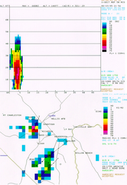
In reflectivity
Reflectivity
In optics and photometry, reflectivity is the fraction of incident radiation reflected by a surface. In general it must be treated as a directional property that is a function of the reflected direction, the incident direction, and the incident wavelength...
(precipitation intensity) data, a tight echo gradient (particularly on the inflow area) and a fan shape generally indicate a supercell
Supercell
A supercell is a thunderstorm that is characterized by the presence of a mesocyclone: a deep, continuously-rotating updraft. For this reason, these storms are sometimes referred to as rotating thunderstorms...
. A V-notch or "flying eagle echo" tend to be most pronounced with intense classic supercells, the type of supercell that produces most of the strongest, largest, and longest lived tornadoes. This is not to be confused with an inflow notch; which is a lower level indentation in the precipitation where there is little to no reflectivity, indicative of strong, organized inflow and a severe storm that is most likely a supercell. The rear inflow notch (or weak echo channel) occurs to the east or north of a mesocyclone and hook echo. Forward inflow notches also occur, particularly on high-precipitation supercells (HP) and quasi-linear convective systems (QLCS).
In the United States and a few other countries, Doppler capable weather radar stations are used. These devices are capable of measuring the radial velocity
Velocity
In physics, velocity is speed in a given direction. Speed describes only how fast an object is moving, whereas velocity gives both the speed and direction of the object's motion. To have a constant velocity, an object must have a constant speed and motion in a constant direction. Constant ...
, including radial direction
Direction (geometry, geography)
Direction is the information contained in the relative position of one point with respect to another point without the distance information. Directions may be either relative to some indicated reference , or absolute according to some previously agreed upon frame of reference Direction is the...
(towards or away from the radar) of the winds in a storm, and so can spot evidence of rotation in storms from more than a hundred miles (160 km) away. A supercell is characterized by a mesocyclone, which is usually first observed in velocity data as a tight, cyclonic structure in the middle levels of the thunderstorm. If it meets certain requirements of strength, duration, and vorticity, it may trip the mesocyclone detection algorithm (MDA). Tornadic signatures are indicated by a cyclonic inbound-outbound velocity couplet, where strong winds flowing in one direction and strong winds flowing in the opposite direction are occurring in very close proximity. The algorithm for this is the tornadic vortex signature (TVS
Tornado vortex signature
A tornado vortex signature or tornadic vortex signature, abbreviated TVS, is a Doppler weather radar detected rotation algorithm that indicates the likely presence of a strong mesocyclone that is in some stage of tornadogenesis...
). TVS often also forms first in the middle levels of the thunderstorm and may descend and tighten into a tornado. The TVS is smaller and found at lower level than the MDA, and usually is the tornado cyclone not the actual tornadic circulation. The TVS is, however, indicative of a likely tornado or an incipient tornado. The couplet and TVS typically precede tornado formation by 10–30 minutes but may occur at nearly the same time or precede the tornado by 45 minutes or more. The hook echo
Hook echo
The hook echo is one of the classical hallmarks of tornado-producing supercell thunderstorms as seen on a weather radar. The echo is produced by rain, hail, or even debris being wrapped around the supercell...
feature is formed as the RFD
Rear flank downdraft
The rear flank downdraft or RFD is a region of dry air wrapping around the back of a mesocyclone in a supercell thunderstorm. These areas of descending air are thought to be essential in the production of many supercellular tornadoes...
occludes precipitation around the mesocyclone and is also indicative of a probable tornado (tornadogenesis usually ensues shortly after the RFD reaches the surface).
After the implementation of the WSR-88D
NEXRAD
NEXRAD or Nexrad is a network of 159 high-resolution Doppler weather radars operated by the National Weather Service, an agency of the National Oceanic and Atmospheric Administration within the United States Department of Commerce...
network in the U.S., the probability of detection of tornadoes increased substantially, the average lead time rose from four minutes to thirteen minutes, and a 2005 NOAA report estimates that as a result of improved warnings that there are 45 percent fewer fatalities and 40 percent fewer injuries annually. Dual-polarization
Polarimetry
Polarimetry is the measurement and interpretation of the polarization of transverse waves, most notably electromagnetic waves, such as radio or light waves...
radar, being implemented to the US NEXRAD
NEXRAD
NEXRAD or Nexrad is a network of 159 high-resolution Doppler weather radars operated by the National Weather Service, an agency of the National Oceanic and Atmospheric Administration within the United States Department of Commerce...
network, may provide enhanced warning of tornadoes and severe winds and hail associated with the hook echo due to distinct precipitation drop characteristics. Polarimetric radar boosts precipitation observation and prediction, especially rainfall rates, hail detection, and distinguishing precipitation types. Proposed radar technologies, such as phased array
Phased array
In wave theory, a phased array is an array of antennas in which the relative phases of the respective signals feeding the antennas are varied in such a way that the effective radiation pattern of the array is reinforced in a desired direction and suppressed in undesired directions.An antenna array...
and CASA, would further improve observations and forecasts by increasing the temporal and spatial resolution of scans in the former as well as providing low-level radar data over a wide area in the latter.
Hail, downburst and downpour
Three body scatter spike
A hail spike or three body scatter spike is an artifact on a weather radar display indicative of large hail. They are identified by a spike of weak reflectivity echoes that extend out from a thunderstorm, and away from the radar site.- Cause :...
in the reflectivity pattern is an important clue. It is an area of weak reflectivity extending away from the radar immediately behind a thunderstorm with hail. It is caused by radiation from the radar bouncing from hailstone to hailstone or the ground before being reflected back to the radar. The time delay between the backscattered radiation from the storm and the one with multiple paths causes the reflectivity from the hail to appear to come from a farther range than the actual storm. However, this artefact is visible mostly for extremely large hail.
What is needed is a knowledge of the water content in the thunderstorm, the freezing level and the height of the summit of the precipitation. One way of calculating the water content is to transform the reflectivities in rain rate at all levels in the clouds and to sum it up. This is done by an algorithm called Vertically integrated liquid
Vertically integrated liquid
Vertically integrated liquid is an estimate of the total mass of precipitation in the clouds. The measurement is obtained by observing the reflectivity of the air which is obtained with weather radar...
, or VIL. This value represent the total amount of liquid water in the cloud that is available. If the cloud would rain out completely, it would be the amount of rain falling on the ground and one can estimate with VIL the potential for flash flood
Flash flood
A flash flood is a rapid flooding of geomorphic low-lying areas—washes, rivers, dry lakes and basins. It may be caused by heavy rain associated with a storm, hurricane, or tropical storm or meltwater from ice or snow flowing over ice sheets or snowfields...
.
However, the reflectivities are greatly enhanced by hail and VIL is greatly overestimating the rain potential in presence of hail. On the other hand, National Weather Service
National Weather Service
The National Weather Service , once known as the Weather Bureau, is one of the six scientific agencies that make up the National Oceanic and Atmospheric Administration of the United States government...
meteorologists have found that the VIL density, that is to say VIL divided by the maximum height of the 18 dBZ
DBZ (meteorology)
dBZ stands for decibels of Z. It is a meteorological measure of equivalent reflectivity of a radar signal reflected off a remote object. The reference level for Z is 1 mm6 m−3, which is equal to 1 μm3...
in the cloud, is a good indicator of the presence of hail when it reach 3.5. This is a crude yes/no index and other algorithms have been developed involving VIL and the freezing level height. More recently, dual polarization of weather radar have shown promising direct detection of hail.
VIL can be used to estimate the potential for downburst
Downburst
A downburst is created by an area of significantly rain-cooled air that, after reaching ground level, spreads out in all directions producing strong winds. Unlike winds in a tornado, winds in a downburst are directed outwards from the point where it hits land or water...
, too. A convective downdraft is linked to three forces in the vertical, namely perturbation pressure gradient force, buoyancy force and precipitation loading. The pressure gradient force was neglected as it has significant effect only on the updraft in supercells. With this assumption and other simplifications (e.g. requiring the environment of the air parcel to be static on the time scale of the downdraft). The resulting momentum equation is integrated over height to yield the kinetic energy
Kinetic energy
The kinetic energy of an object is the energy which it possesses due to its motion.It is defined as the work needed to accelerate a body of a given mass from rest to its stated velocity. Having gained this energy during its acceleration, the body maintains this kinetic energy unless its speed changes...
of the parcel on descending to the surface and is found to be the negative CAPE
Convective available potential energy
In meteorology, convective available potential energy , sometimes, simply, available potential energy , is the amount of energy a parcel of air would have if lifted a certain distance vertically through the atmosphere...
of a dry air parcel injected into the storm, plus de motion of the convective cell. S. R. Stewart, from NWS, has published in 1991 an equation relating VIL and the echo tops that give the potential for surface gust using this concept. This is a predictive result that gives a certain lead time. With the Doppler velocity data, the meteorologist can see the downdraft and gust fronts happening, but since this a small scale feature, detection algorithms have been developed to point convergence and divergence areas under a thunderstorm on the radar display.
Satellite imagery
Weather satellite
The weather satellite is a type of satellite that is primarily used to monitor the weather and climate of the Earth. Satellites can be either polar orbiting, seeing the same swath of the Earth every 12 hours, or geostationary, hovering over the same spot on Earth by orbiting over the equator while...
s, which aid in the nowcasting of severe convective and tornadic storms. These images are available in the visible
Visible spectrum
The visible spectrum is the portion of the electromagnetic spectrum that is visible to the human eye. Electromagnetic radiation in this range of wavelengths is called visible light or simply light. A typical human eye will respond to wavelengths from about 390 to 750 nm. In terms of...
and infrared
Infrared
Infrared light is electromagnetic radiation with a wavelength longer than that of visible light, measured from the nominal edge of visible red light at 0.74 micrometres , and extending conventionally to 300 µm...
domains. The infrared (IR: 10-13 µm
Micrometre
A micrometer , is by definition 1×10⁻⁶ of a meter .In plain English, it means one-millionth of a meter . Its unit symbol in the International System of Units is μm...
) images permit estimation of the top height of the clouds, according to the air mass
Air mass
In meteorology, an air mass is a volume of air defined by its temperature and water vapor content. Air masses cover many hundreds or thousands of square miles, and adopt the characteristics of the surface below them. They are classified according to latitude and their continental or maritime...
soundings of the day, and the visible (VIS: 0.5-1.1 µm) ones will show the shape of the storms by its brightness and shadow produced. Meteorologists can extract information about the development stage and subsequent traits of thunderstorms by recognizing specific signatures in both domains. Visible imagery permits the most detailed imagery whereas infrared imagery has the advantage of availability at night. Sensors on satellites can also detect emissions from water vapor (WV: 6-7 µm), but mostly in the middle to upper levels of the troposphere
Troposphere
The troposphere is the lowest portion of Earth's atmosphere. It contains approximately 80% of the atmosphere's mass and 99% of its water vapor and aerosols....
, so thunderstorms are only seen after being well developed. It is, however, useful in convective storm prediction, as it illustrates the placement and movement of air masses and of moisture, as well as shortwaves
Shortwave (meteorology)
A shortwave or shortwave trough is an embedded kink in the trough / ridge pattern. This is the opposite of longwaves, which are responsible for synoptic scale systems, although shortwaves may be contained within or found ahead of longwaves and range from the mesocale to the synoptic scale...
and areas of vorticity and lift.
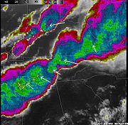
Severe storms have a very strong updraft. The rising air parcels in that column accelerate and will overshoot the equilibrium level
Equilibrium level
In meteorology, the equilibrium level , or level of neutral buoyancy , or limit of convection , is the height at which a rising parcel of air is at a temperature of equal warmth to it....
before being pulled back by negative buoyancy. This mean the cloud tops will reach higher levels than the surrounding cloud in the updraft region. This overshooting top
Overshooting top
An overshooting top is a dome-like protrusion that shoots out of the top of the anvil of a thunderstorm. When an overshooting top is present for 10 minutes or longer, it is a strong indication that the thunderstorm may be severe....
will be noticeable by a colder temperature region in the thunderstorm on infrared images. Another signature associated with this situation is the Enhanced-V feature where the cold cloud top
Cloud top
The cloud top is the highest altitude of the visible portion of the cloud. It is traditionally expressed either in metres above the Earth surface, or as the corresponding pressure level in hectopascal .-Measurement:The cloud top is where the snow, rain and sleet come from.Cloud top...
s forming at the overshooting top fan out in a V shape as cloud matter is blown downwind at that level. Both features can be seen on visible satellite imagery, during daytime, by the shadows they cast on surrounding clouds.
In multicellular
Multicellular thunderstorm
A multicellular thunderstorm cluster is a thunderstorm that is composed of multiple cells, each being at a different stage in the life cycle of a thunderstorm. It looks like several anvils clustered together. A cell is an updraft/downdraft couplet...
storms and squall line
Squall line
A squall line is a line of severe thunderstorms that can form along or ahead of a cold front. In the early 20th century, the term was used as a synonym for cold front. It contains heavy precipitation, hail, frequent lightning, strong straight-line winds, and possibly tornadoes and waterspouts....
s, the mid-level jet stream
Jet stream
Jet streams are fast flowing, narrow air currents found in the atmospheres of some planets, including Earth. The main jet streams are located near the tropopause, the transition between the troposphere and the stratosphere . The major jet streams on Earth are westerly winds...
is often intersecting the line and its dry air introduced into the cloud is negatively unstable. This results in a drying of the cloudy air in the region where the jet plunge groundward. On the back edge of the line, this shows as clear notches where one can find stronger downdrafts at the surface. These kind of lines will have a very characteristic undulating pattern caused by the interference of the gusts fronts coming from different parts of the line.
Finally, in any type of thunderstorms, the surface cold pool of air associated the downdraft will stabilize the air and form a cloud free area which will end along the gust front
Outflow boundary
An outflow boundary, also known as a gust front, is a storm-scale or mesoscale boundary separating thunderstorm-cooled air from the surrounding air; similar in effect to a cold front, with passage marked by a wind shift and usually a drop in temperature and a related pressure jump...
. This mesoscale front, when moving into a warm and unstable air mass, will lift it and cumulus cloud
Cumulus cloud
Cumulus clouds are a type of cloud with noticeable vertical development and clearly defined edges. Cumulus means "heap" or "pile" in Latin. They are often described as "puffy" or "cotton-like" in appearance. Cumulus clouds may appear alone, in lines, or in clusters...
s appear on satellite pictures. This line is likely the point of further convection and storms. One can notice it at the leading edge of a squall line, in the southeastern quadrant of a typical supercell (in the northern hemisphere), or different regions around other thunderstorms. They may also be visible as an outflow boundary
Outflow boundary
An outflow boundary, also known as a gust front, is a storm-scale or mesoscale boundary separating thunderstorm-cooled air from the surrounding air; similar in effect to a cold front, with passage marked by a wind shift and usually a drop in temperature and a related pressure jump...
hours or days after convection and can pinpoint areas of favored thunderstorm development, possible direction of movement, and even likelihood for tornadoes. The speed of forward movement of the outflow boundary or gust front to some degree modulates the likelihood of tornadoes and helps determine whether a storm will be enhanced by its presence or the inflow be choked off thus weakening and possibly killing the storm. Thunderstorms may move along slow moving or stationary outflow boundaries and tornadoes are more likely; whereas fast moving gust fronts in many cases weaken thunderstorms after impact and are less likely to produce tornadoes --although brief tornadoes may occur at the time of impact. Fast moving gust fronts may eventually decelerate and become slow moving or stationary outflow boundaries with the characteristic "agitated area" of cumulus fields previously mentioned.
Lightning detection
Usually in conjunction with data sources such as weather radar and satellites, lightning detection systems are sometimes utilized to pinpoint where thunderstorms are occurring (and to identify lightningLightning
Lightning is an atmospheric electrostatic discharge accompanied by thunder, which typically occurs during thunderstorms, and sometimes during volcanic eruptions or dust storms...
hazard). Currently, most lightning data provided in real-time is from terrestrial sources, specifically, networks of ground-based sensors, although airborne sensors are also in operation. Most of these only provide latitude & longitude, time, and polarity of cloud-to-ground strikes within a limited range. Increasing in sophistication and availability, and affording data for a very wide area, are satellite-based lightning detectors which initially included optical sensors indicating flash rates and horizontal location but now radio frequency
Radio frequency
Radio frequency is a rate of oscillation in the range of about 3 kHz to 300 GHz, which corresponds to the frequency of radio waves, and the alternating currents which carry radio signals...
receivers that can identify intra-cloud flashes with the addition of altitude, as well.
Lightning data is useful in suggesting intensity and organization of convective cells as well trends in thunderstorm activity (particularly growth, and to a lesser degree, decay). It is also useful in the early stages of thunderstorm development. This was especially true when visible and infrared satellite data was delayed, but continues to be useful in detecting thunderstorms in stages of development before there is a substantial radar signature or for areas where radar data is lacking. Coming advances in research and observations should improve forecasts of severe weather and increase warning time.
Personal lightning detection systems are also available, which may provide strike time, azimuth, and distance. In addition, lightning prediction system
Lightning prediction system
A lightning prediction system detects atmospheric conditions likely to produce lightning strikes in a certain area and sounds an auditory alert, warning those nearby that lightning is imminent and giving them the chance to find safety before the storm actually impacts the area...
s are available and used mostly by parks and other outdoor recreational facilities, or meteorologists contracted to provide weather information for them.
See also
- National Severe Storms LaboratoryNational Severe Storms LaboratoryThe National Severe Storms Laboratory is a National Oceanic and Atmospheric Administration weather research laboratory located at the National Weather Center in Norman, Oklahoma....
- Storm Prediction CenterStorm Prediction CenterThe Storm Prediction Center , located in Norman, Oklahoma, is tasked with forecasting the risk of severe thunderstorms and tornadoes in the contiguous United States. The agency issues convective outlooks, mesoscale discussions, and watches as a part of this process...
- Warning Decision Training BranchWarning Decision Training BranchThe Warning Decision Training Branch is one of three training organizations in the NWS Training Division which also includes the Forecast Decision Training Branch and the NWS Training Center...
- Robert C. MillerRobert C. MillerCol. Robert C. Miller, USAF , was an American meteorologist, who pioneered severe convective storms forecasting and applied research, developing an empirical forecasting method, identifying many features associated with severe thunderstorms, a forecast checklist and manuals, and is known for the...
, a pioneer in the field of forecasting tornadoes
External links
- NSSL Severe Weather Primer
- NSSL Warning Research and Development
- NOAA Hazardous Weather Testbed
- Tornado Warning Guidance (NWS Warning Decision Training Branch)
- Supercell Structure and Dynamics (NWSNational Weather ServiceThe National Weather Service , once known as the Weather Bureau, is one of the six scientific agencies that make up the National Oceanic and Atmospheric Administration of the United States government...
) - Tornadogenesis cascade paradigm and schematic (San Francisco State UniversitySan Francisco State UniversitySan Francisco State University is a public university located in San Francisco, California. As part of the 23-campus California State University system, the university offers over 100 areas of study from nine academic colleges...
) - An Introduction to Storm Observation and Reporting (NWS)
- An Online Meteorology Guide: Severe Storms (University of Illinois)
- Weather Glossary for Storm Spotters (NOAA Technical Memorandum NWS SR-145)
- Thunderstorms (NWS JetStream Online Weather School)