
Sourland Mountain
Encyclopedia
Sourland Mountain is a 17 miles (27 km) long ridge
in central New Jersey
, extending from the Delaware River
at Lambertville
to the western end of Hillsborough Township
near the community of Neshanic
, through Montgomery Township
and into Hopewell Township
in Mercer County
. It comprises the largest contiguous forest in Central Jersey
, nearly 90 square miles (233 km²) in area. The highest point is only 568 feet (173.1 m) above sea level, but the way it rises steeply from the surrounding farmland has earned it the title of 'mountain'. The ridge itself sits within a larger area of rough terrain called The Sourlands
.
 The origin of the name Sourland is unclear and a few theories exist. It could be derived from the term “sorrel-land” which describes the sorrel (reddish-brown) colored soils encountered by the pioneering German farmers, or German immigrants from the Sauerland
region simply anglicized the name of their home region. Another possible source for the name is from 17th century Dutch settlers who referred to the region as "sauer landt" because the region was clearly not suitable for farming. To this day, the area remains relatively undeveloped - besides being unsuitable for farming, the hard igneous rock, nonporous clay soils, steep slopes and perched wetlands create groundwater conditions which make the area difficult for drilling wells and installing septic systems.
 Before the arrival of Europeans, Sourland Mountain was inhabited by Unami speaking Lenape
, in particular the Musconetcongs. However, settlements and farms along the mountain seem to have been restricted to river valleys due to the poor, rocky soils upslope. There is evidence indicating the Delaware River likely supported at least one such Lenape settlement at the southern foot of the mountain around present-day Lambertville, New Jersey
.
In the 18th and 19th century, the mountain’s many streams were heavily exploited as an energy source for various mills. At the same time, Sourland Mountain became a valuable source of lumber. However, by the time of the Civil War, most of forests that had previously covered the mountain had been depleted. In place of these forests, farms sprang up along the more easily managed parts of the mountain, and rural villages were formed. Rock quarries and a local pottery industry were also started around this time.
By the end of the 19th century, Sourland Mountain supported a thriving peach farming industry. But a blight just before the start of the new century, as wells as a statewide shift to an industrial economy, eventually crippled agriculture on the mountain. Rural villages soon disappeared, and new forests began to grow over abandoned farmland. The only pre-20th century industry that was able to survive into the modern era was rock quarrying –the mountain’s trap rock
was crushed and used to build railroad beds and roads throughout the region.
For the first half of the last century, Sourland Mountain remained a remote part of New Jersey, with few connections to nearby metropolitan areas. This changed in the 1940s when new road construction made the mountain more accessible, allowing suburbia to begin invading its valleys and slopes. Today the mountain acts as a watershed for surrounding communities, while at the same time providing recreational opportunities to Central New Jersey.
.
Partly adjacent to Sourland Mountain is a sizeable traprock ridge which extends eastward from Pennington Mountain for approximately nine miles, forming (from west to east) Mount Rose
, Rocky Hill
, and Ten Mile Run Mountain. West of the main ridge, near Flemington
, is Prospect Hill, a volcanic remnant lying along the western edge of the Amwell Valley
. The hill appears to be geologically linked to Sourland Mountain by a volcanic dike
running mostly beneath the surface.
 Sourland Mountain was formed 200 million years ago by a plutonic intrusion
of a hard igneous rock
, diabase
, into the Brunswick Shale
. The intrusion occurred as tectonic forces created the Newark Basin
, a prehistoric rift valley active near the rift which ultimately spread North America and Africa apart. The parallel ridges of the mountain were probably formed by magma seeping up through linear faults created during the rifting process
During the early Jurassic
the rift which formed the Newark Basin failed, and the intrusion which would eventually become Sourland Mountain ceased growing. Initially, the vast majority of volcanic material remained within the crust. However, the diabase and related hornfels
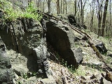
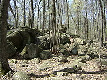
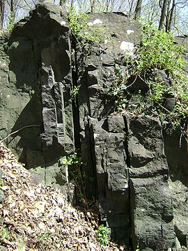
which form the backbone of the mountain are a type of highly erosion resistant stone known as trap rock
. Consequently, millions of years of erosion lowered the more easily worked shale surrounding the intrusion, turning it into the elevated ridges which currently comprise Sourland Mountain.
The Palisades Sill
, in northeastern New Jersey and southeastern New York, was not only formed under similar circumstances to Sourland Mountain, it is at least partly contiguous with it. The ridge forming Mount Rose, Rocky Hill, and Ten Mile Run Mountain, is a continuation of the Palisades which connects to Pennington Mountain. South of Pennington Mountain the Palisades sill and Sourland Mountain's eastern ridge are essentially the same feature.
Like the Palisades, Sourland Mountain exhibits volcanic dikes which extend away from the main ridge. One such dike extending northwest from Sourland Mountain has been determined to be responsible for the creation of Prospect Hill, an extrusive basalt peak near Flemington, New Jersey. Prospect Hill marks the only known location where Sourland Mountain’s magma actually erupted to the surface. In this respect, it is similar to Snake Hill
, which it most likely a volcanic plug linked to the Palisades.
One of the key differences between Sourland Mountain and the other volcanic mountains of the Newark Basin, including the Watchungs and the Palisades
, is that it has not been touched by glaciers. This has left the mountain with a mantle of Triassic argillite
, which covers much of the underlying trap rock and comprises the bulk of Pheasant Hill. The impermeability of argillite is primarily to blame for Sourland Mountain’s extremely poor aquifer.
ecoregion
It is an environmentally sensitive area and is home to several rare and threatened plants and animals, including: trout lilies
, wood anemones
, ginseng, spotted salamander
, pileated woodpecker
, bobcat
, wood turtle
, barred owl
, bobolink
, Cooper's hawk
, grasshopper sparrow
, savannah sparrow
, upland sandpiper
, and the scarlet tanager
.
The Sourlands serve as a stopover area for migratory birds that travel between South and Central America and the Arctic as well as forest birds migrating between Washington, D.C.
, and Boston. The area also supports a large population of deep-woods birds such as scarlet tanagers and barred owls.
Being the largest contiguous forest between the Pine Barrens
and the New Jersey Highlands, it is critical to the survival of neotropical migrant birds and other rare species of plants and animals. D&R Greenway Land Trust's partner in Mexico, Amigos de Calakmul, protects bird habitat at the southern end of the migratory flyway.
in Somerset County.
Nearby is the Sourland Mountain Nature Preserve, located in Hunterdon County.
and George Bernard Shaw
, aviator Charles Lindbergh
, patriot John Hart (signer of the Declaration of Independence), and the painter George Bellows
.
In March 1932, the Mountain was the scene of the notorious kidnapping and murder of the Lindbergh baby
. The Lindberghs had chosen the Mountain for their new home precisely because of its isolation and inaccessibility.
Ridge
A ridge is a geological feature consisting of a chain of mountains or hills that form a continuous elevated crest for some distance. Ridges are usually termed hills or mountains as well, depending on size. There are several main types of ridges:...
in central New Jersey
New Jersey
New Jersey is a state in the Northeastern and Middle Atlantic regions of the United States. , its population was 8,791,894. It is bordered on the north and east by the state of New York, on the southeast and south by the Atlantic Ocean, on the west by Pennsylvania and on the southwest by Delaware...
, extending from the Delaware River
Delaware River
The Delaware River is a major river on the Atlantic coast of the United States.A Dutch expedition led by Henry Hudson in 1609 first mapped the river. The river was christened the South River in the New Netherland colony that followed, in contrast to the North River, as the Hudson River was then...
at Lambertville
Lambertville, New Jersey
Lambertville is a city in Hunterdon County, New Jersey, United States. As of the 2010 United States Census, the city population was 3,906.Lambertville was originally incorporated as a town by an Act of the New Jersey Legislature on March 1, 1849, from portions of West Amwell Township...
to the western end of Hillsborough Township
Hillsborough Township, New Jersey
Hillsborough Township is a Township in Somerset County, New Jersey, United States. As of the 2010 United States Census, the township population was 38,303....
near the community of Neshanic
Neshanic, New Jersey
Neshanic is an unincorporated community within Hillsborough Township, New Jersey in Somerset County, New Jersey. Neshanic is located near the South Branch Raritan River.-History:...
, through Montgomery Township
Montgomery Township, New Jersey
Montgomery Township is a Township in Somerset County, New Jersey, United States. As of the United States 2010 Census, the township population was 22,254, which represents growth of 27% since 2000 and more than 130% since the 1990 Census population figure of 9,612.Montgomery Township was...
and into Hopewell Township
Hopewell Township, Mercer County, New Jersey
As of the 2010 United States Census, the township's population was 17,304. The racial makeup of the township was 86.7% White, 2.1% African American, 0.1% Native American, 8.9% Asian, 0.0% Pacific Islander, 0.5% from other races, and 1.7% from two or more races...
in Mercer County
Mercer County, New Jersey
As of the census of 2000, there were 350,761 people, 125,807 households, and 86,303 families residing in the county. The population density was 1,552 people per square mile . There were 133,280 housing units at an average density of 590 per square mile...
. It comprises the largest contiguous forest in Central Jersey
Central Jersey
Central Jersey is a common designation for a region of the state of New Jersey in the United States of America. Trenton is considered the boundary between designated "North Jersey" and "South Jersey"...
, nearly 90 square miles (233 km²) in area. The highest point is only 568 feet (173.1 m) above sea level, but the way it rises steeply from the surrounding farmland has earned it the title of 'mountain'. The ridge itself sits within a larger area of rough terrain called The Sourlands
The Sourlands
The Sourlands is a region in the U.S. state of New Jersey that includes portions of Hunterdon County, Mercer County and Somerset County. It is centered around Sourland Mountain and comprises parts of Lambertville, East Amwell, West Amwell, Hillsborough, Hopewell Boro, Hopewell Township, Montgomery...
.
Etymology
Sauerland
The Sauerland is a rural, hilly area spreading across most of the south-eastern part of North Rhine-Westphalia, in parts heavily forested and, apart from the major valleys, sparsely inhabited...
region simply anglicized the name of their home region. Another possible source for the name is from 17th century Dutch settlers who referred to the region as "sauer landt" because the region was clearly not suitable for farming. To this day, the area remains relatively undeveloped - besides being unsuitable for farming, the hard igneous rock, nonporous clay soils, steep slopes and perched wetlands create groundwater conditions which make the area difficult for drilling wells and installing septic systems.
History
Lenape
The Lenape are an Algonquian group of Native Americans of the Northeastern Woodlands. They are also called Delaware Indians. As a result of the American Revolutionary War and later Indian removals from the eastern United States, today the main groups live in Canada, where they are enrolled in the...
, in particular the Musconetcongs. However, settlements and farms along the mountain seem to have been restricted to river valleys due to the poor, rocky soils upslope. There is evidence indicating the Delaware River likely supported at least one such Lenape settlement at the southern foot of the mountain around present-day Lambertville, New Jersey
Lambertville, New Jersey
Lambertville is a city in Hunterdon County, New Jersey, United States. As of the 2010 United States Census, the city population was 3,906.Lambertville was originally incorporated as a town by an Act of the New Jersey Legislature on March 1, 1849, from portions of West Amwell Township...
.
In the 18th and 19th century, the mountain’s many streams were heavily exploited as an energy source for various mills. At the same time, Sourland Mountain became a valuable source of lumber. However, by the time of the Civil War, most of forests that had previously covered the mountain had been depleted. In place of these forests, farms sprang up along the more easily managed parts of the mountain, and rural villages were formed. Rock quarries and a local pottery industry were also started around this time.
By the end of the 19th century, Sourland Mountain supported a thriving peach farming industry. But a blight just before the start of the new century, as wells as a statewide shift to an industrial economy, eventually crippled agriculture on the mountain. Rural villages soon disappeared, and new forests began to grow over abandoned farmland. The only pre-20th century industry that was able to survive into the modern era was rock quarrying –the mountain’s trap rock
Trap rock
Trap rock is a form of igneous rock that tends to form polygonal vertical fractures, most typically hexagonal, but also four to eight sided. The fracture pattern forms when magma of suitable chemical composition intrudes as a sill or extrudes as a thick lava flow, and slowly cools.Because of the...
was crushed and used to build railroad beds and roads throughout the region.
For the first half of the last century, Sourland Mountain remained a remote part of New Jersey, with few connections to nearby metropolitan areas. This changed in the 1940s when new road construction made the mountain more accessible, allowing suburbia to begin invading its valleys and slopes. Today the mountain acts as a watershed for surrounding communities, while at the same time providing recreational opportunities to Central New Jersey.
Geography
As a range, Sourland Mountain includes the main ridge and smaller secondary ridges. Near the northern part of the range, Pheasant Hill forms a parallel rise on the east flank of the main ridge. South of Pheasant Hill, a somewhat detached ridge forms Pennington Mountain. This same ridge, which continues to run parallel to the main ridge, is broken in three more places south of Pennington Mountain, forming (from north to south) Mount Canoe, Baldpate Mountain, and Strawberry Hill. A knob in the shallow valley between Strawberry Hill and the southernmost stretch of the main ridge forms Belle Mountain. Goat Hill comprises the highest point of the main ridge before reaching the southernmost end of Sourland Mountain at the Delaware RiverDelaware River
The Delaware River is a major river on the Atlantic coast of the United States.A Dutch expedition led by Henry Hudson in 1609 first mapped the river. The river was christened the South River in the New Netherland colony that followed, in contrast to the North River, as the Hudson River was then...
.
Partly adjacent to Sourland Mountain is a sizeable traprock ridge which extends eastward from Pennington Mountain for approximately nine miles, forming (from west to east) Mount Rose
Mount Rose (New Jersey)
Mount Rose is a narrow section of the Rocky Hill Ridge in Hopewell Township, New Jersey which is 420 feet above sea level. The ridge's western end is at The Sourlands at Hopewell-Pennington Road and its eastern end is near Province Line Road. The ridge is a diabase intrusion and unlike many of...
, Rocky Hill
Rocky Hill Ridge
Rocky Hill Ridge, also known as the Mount Lucas-Rocky Hill Ridge, named after Lucas Voorhees, an 18th century landowner, is a diabase trap rock ridge running west to east in the U.S. State of New Jersey. Diabase intrusions form Baldpate Mountain and Pennington Mountain, the Mount Rose extension of...
, and Ten Mile Run Mountain. West of the main ridge, near Flemington
Flemington, New Jersey
Flemington is a borough in Hunterdon County, New Jersey, United States. As of the United States 2010 Census, the borough population was 4,581. It is the county seat of Hunterdon County....
, is Prospect Hill, a volcanic remnant lying along the western edge of the Amwell Valley
Amwell Valley
The Amwell Valley is a small valley in Hunterdon County, New Jersey, between the Hunterdon Plateau and the Sourlands. It comprises Stockton, parts of Delaware Township, West Amwell, East Amwell, Flemington and Raritan Township. The region borders the Delaware River to the west and the South...
. The hill appears to be geologically linked to Sourland Mountain by a volcanic dike
Dike (geology)
A dike or dyke in geology is a type of sheet intrusion referring to any geologic body that cuts discordantly across* planar wall rock structures, such as bedding or foliation...
running mostly beneath the surface.
Geology
Intrusion
An intrusion is liquid rock that forms under Earth's surface. Magma from under the surface is slowly pushed up from deep within the earth into any cracks or spaces it can find, sometimes pushing existing country rock out of the way, a process that can take millions of years. As the rock slowly...
of a hard igneous rock
Igneous rock
Igneous rock is one of the three main rock types, the others being sedimentary and metamorphic rock. Igneous rock is formed through the cooling and solidification of magma or lava...
, diabase
Diabase
Diabase or dolerite is a mafic, holocrystalline, subvolcanic rock equivalent to volcanic basalt or plutonic gabbro. In North American usage, the term diabase refers to the fresh rock, whilst elsewhere the term dolerite is used for the fresh rock and diabase refers to altered material...
, into the Brunswick Shale
Passaic Formation
The Passaic Formation is a mapped bedrock unit in Pennsylvania, New Jersey, and New York. It was previously known as the Brunswick Formation since it was first described in the vicinity of New Brunswick, New Jersey. It is now named for the city of Passaic, New Jersey, which is near where its type...
. The intrusion occurred as tectonic forces created the Newark Basin
Newark Basin
The Newark Basin is a sediment-filled rift basin located mainly in northern New Jersey but also stretching into south-eastern Pennsylvania and southern New York. It is part of the system of Eastern North America Rift Basins.-Geology:...
, a prehistoric rift valley active near the rift which ultimately spread North America and Africa apart. The parallel ridges of the mountain were probably formed by magma seeping up through linear faults created during the rifting process
During the early Jurassic
Jurassic
The Jurassic is a geologic period and system that extends from about Mya to Mya, that is, from the end of the Triassic to the beginning of the Cretaceous. The Jurassic constitutes the middle period of the Mesozoic era, also known as the age of reptiles. The start of the period is marked by...
the rift which formed the Newark Basin failed, and the intrusion which would eventually become Sourland Mountain ceased growing. Initially, the vast majority of volcanic material remained within the crust. However, the diabase and related hornfels
Hornfels
Hornfels is the group designation for a series of contact metamorphic rocks that have been baked and indurated by the heat of intrusive igneous masses and have been rendered...
which form the backbone of the mountain are a type of highly erosion resistant stone known as trap rock
Trap rock
Trap rock is a form of igneous rock that tends to form polygonal vertical fractures, most typically hexagonal, but also four to eight sided. The fracture pattern forms when magma of suitable chemical composition intrudes as a sill or extrudes as a thick lava flow, and slowly cools.Because of the...
. Consequently, millions of years of erosion lowered the more easily worked shale surrounding the intrusion, turning it into the elevated ridges which currently comprise Sourland Mountain.
The Palisades Sill
Palisades Sill
The Palisades Sill is a Triassic, 200 Ma diabase intrusion. It extends through portions of New York and New Jersey. It is most noteworthy for The Palisades, the cliffs that rise steeply above the western bank of the Hudson River...
, in northeastern New Jersey and southeastern New York, was not only formed under similar circumstances to Sourland Mountain, it is at least partly contiguous with it. The ridge forming Mount Rose, Rocky Hill, and Ten Mile Run Mountain, is a continuation of the Palisades which connects to Pennington Mountain. South of Pennington Mountain the Palisades sill and Sourland Mountain's eastern ridge are essentially the same feature.
Like the Palisades, Sourland Mountain exhibits volcanic dikes which extend away from the main ridge. One such dike extending northwest from Sourland Mountain has been determined to be responsible for the creation of Prospect Hill, an extrusive basalt peak near Flemington, New Jersey. Prospect Hill marks the only known location where Sourland Mountain’s magma actually erupted to the surface. In this respect, it is similar to Snake Hill
Snake Hill
Snake Hill is an igneous rock intrusion jutting some 150 feet up from the floor of the Meadowlands in Secaucus, New Jersey, USA. It was largely obliterated by quarrying in the 1960s that reduced its height by one-quarter and its base area by four fifths...
, which it most likely a volcanic plug linked to the Palisades.
One of the key differences between Sourland Mountain and the other volcanic mountains of the Newark Basin, including the Watchungs and the Palisades
Palisades Sill
The Palisades Sill is a Triassic, 200 Ma diabase intrusion. It extends through portions of New York and New Jersey. It is most noteworthy for The Palisades, the cliffs that rise steeply above the western bank of the Hudson River...
, is that it has not been touched by glaciers. This has left the mountain with a mantle of Triassic argillite
Argillite
An argillite is a fine-grained sedimentary rock composed predominantly of indurated clay particles. Argillaceous rocks are basically lithified muds and oozes. They contain variable amounts of silt-sized particles. The argillites grade into shale when the fissile layering typical of shale is...
, which covers much of the underlying trap rock and comprises the bulk of Pheasant Hill. The impermeability of argillite is primarily to blame for Sourland Mountain’s extremely poor aquifer.
Wildlife
Sourland Mountain is in the Northeastern coastal forestsNortheastern coastal forests
The Northeastern coastal forests are a temperate broadleaf and mixed forests ecoregion of the northeastern United States. The ecoregion covers an area of 34,630 sq miles encompassing the Piedmont and coastal plain of seven states, extending from northern Maryland and Delaware through southeast...
ecoregion
Ecoregion
An ecoregion , sometimes called a bioregion, is an ecologically and geographically defined area that is smaller than an ecozone and larger than an ecosystem. Ecoregions cover relatively large areas of land or water, and contain characteristic, geographically distinct assemblages of natural...
It is an environmentally sensitive area and is home to several rare and threatened plants and animals, including: trout lilies
Erythronium
Erythronium is a genus of 20-30 species of spring-flowering perennial plants with long, tooth-like bulbs and attractive pendant flowers, native to forest and meadow in temperate regions of the Northern Hemisphere.-Species:-Uses:The bulb is edible as a root vegetable, cooked or dried, and can be...
, wood anemones
Anemone quinquefolia
Anemone quinquefolia is an early-spring flowering plant in the genus Anemone, native to North America. It is commonly called Wood Anemone, like Anemone nemorosa, a closely related European species...
, ginseng, spotted salamander
Spotted Salamander
The Spotted Salamander or Yellow-spotted Salamander is a mole salamander common in the eastern United States and Canada. The Spotted Salamander is the State amphibian of South Carolina. It has recently been found that its embryos have algae living inside them in a mutualistic...
, pileated woodpecker
Pileated Woodpecker
The Pileated Woodpecker is a very large North American woodpecker, almost crow-sized, inhabiting deciduous forests in eastern North America, the Great Lakes, the boreal forests of Canada, and parts of the Pacific coast. It is also the largest woodpecker in America.Adults are long, and weigh...
, bobcat
Bobcat
The bobcat is a North American mammal of the cat family Felidae, appearing during the Irvingtonian stage of around 1.8 million years ago . With twelve recognized subspecies, it ranges from southern Canada to northern Mexico, including most of the continental United States...
, wood turtle
Wood Turtle
The wood turtle is a turtle endemic to North America. It is in the genus Glyptemys, a designation given to only one other turtle: the bog turtle. The wood turtle reaches a carapace length of , its defining characteristic being the pyramidal pattern on its upper shell...
, barred owl
Barred Owl
The Barred Owl is a large typical owl. It goes by many other names, including eight hooter, rain owl, wood owl, and striped owl, but is probably best known as the hoot owl.-Description:...
, bobolink
Bobolink
The Bobolink is a small New World blackbird and the only member of genus Dolichonyx.-Description:Adults are 16–18 cm long with short finch-like bills. They weigh about . Adult males are mostly black, although they do display creamy napes, and white scapulars, lower backs and rumps...
, Cooper's hawk
Cooper's Hawk
Cooper's Hawk is a medium-sized hawk native to the North American continent and found from Canada to Mexico. As in many birds of prey, the male is smaller than the female...
, grasshopper sparrow
Grasshopper Sparrow
The Grasshopper Sparrow, Ammodramus savannarum, is a small sparrow. The Ammodramus genus of 11 species inhabit grasslands and marshes....
, savannah sparrow
Savannah Sparrow
The Savannah Sparrow is a small American sparrow. It is the only widely accepted member of the genus Passerculus...
, upland sandpiper
Upland Sandpiper
The Upland Sandpiper is a large shorebird, closely related to the curlews . Older names are the Upland Plover and Bartram's Sandpiper. It is the only member of the genus Bartramia. The genus name and the old common name Bartram's Sandpiper commemorate the American naturalist William Bartram...
, and the scarlet tanager
Scarlet Tanager
The Scarlet Tanager is a medium-sized American songbird. Formerly placed in the tanager family , it and other members of its genus are now classified in the cardinal family . The species's plumage and vocalizations are similar to other members of the cardinal family.-Description:Adults have pale...
.
The Sourlands serve as a stopover area for migratory birds that travel between South and Central America and the Arctic as well as forest birds migrating between Washington, D.C.
Washington, D.C.
Washington, D.C., formally the District of Columbia and commonly referred to as Washington, "the District", or simply D.C., is the capital of the United States. On July 16, 1790, the United States Congress approved the creation of a permanent national capital as permitted by the U.S. Constitution....
, and Boston. The area also supports a large population of deep-woods birds such as scarlet tanagers and barred owls.
Being the largest contiguous forest between the Pine Barrens
Pine Barrens (New Jersey)
The Pine Barrens, also known as the Pinelands, is a heavily forested area of coastal plain stretching across southern New Jersey. The name "pine barrens" refers to the area's sandy, acidic, nutrient-poor soil, to which the crops originally imported by European settlers didn't take well...
and the New Jersey Highlands, it is critical to the survival of neotropical migrant birds and other rare species of plants and animals. D&R Greenway Land Trust's partner in Mexico, Amigos de Calakmul, protects bird habitat at the southern end of the migratory flyway.
Recreation
Small parks and access points make the mountain popular for hiking, mountain biking, hunting, and bird watching. Rock climbing is permitted in certain parks such as Sourland Mountain Preserve in Somerset County, but not in others such as Sourland Mountain Nature Preserve in Hunterdon County. The largest park is the Sourland Mountain PreserveSourland Mountain Preserve
The Sourland Mountain Preserve is located in Hillsborough and Montgomery townships, Somerset County, New Jersey.The main feature of the preserve is the Ridge Trail [white squares], suitable for hiking and off-road biking...
in Somerset County.
Nearby is the Sourland Mountain Nature Preserve, located in Hunterdon County.
Notable inhabitants
Notable residents of the Mountain include: playwrights Eugene O'NeillEugene O'Neill
Eugene Gladstone O'Neill was an American playwright and Nobel laureate in Literature. His poetically titled plays were among the first to introduce into American drama techniques of realism earlier associated with Russian playwright Anton Chekhov, Norwegian playwright Henrik Ibsen, and Swedish...
and George Bernard Shaw
George Bernard Shaw
George Bernard Shaw was an Irish playwright and a co-founder of the London School of Economics. Although his first profitable writing was music and literary criticism, in which capacity he wrote many highly articulate pieces of journalism, his main talent was for drama, and he wrote more than 60...
, aviator Charles Lindbergh
Charles Lindbergh
Charles Augustus Lindbergh was an American aviator, author, inventor, explorer, and social activist.Lindbergh, a 25-year-old U.S...
, patriot John Hart (signer of the Declaration of Independence), and the painter George Bellows
George Bellows
George Wesley Bellows was an American realist painter, known for his bold depictions of urban life in New York City, becoming, according to the Columbus Museum of Art, "the most acclaimed American artist of his generation".-Youth:Bellows was born and raised in Columbus, Ohio...
.
In March 1932, the Mountain was the scene of the notorious kidnapping and murder of the Lindbergh baby
Lindbergh kidnapping
The kidnapping of Charles Augustus Lindbergh, Jr., was the abduction of the son of aviator Charles Lindbergh and Anne Morrow Lindbergh. The toddler, 18 months old at the time, was abducted from his family home in East Amwell, New Jersey, near the town of Hopewell, New Jersey, on the evening of...
. The Lindberghs had chosen the Mountain for their new home precisely because of its isolation and inaccessibility.