

Sheffield Inner Ring Road
Encyclopedia
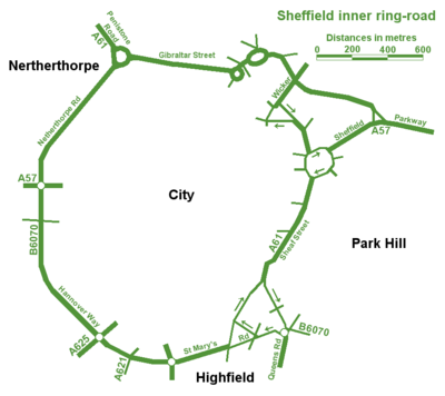
Sheffield Inner Ring Road is a dual-carriageway circling central Sheffield
Sheffield City Centre
Sheffield City Centre—often just referred to as town—is a district of the City of Sheffield, and part of the Sheffield Central ward. It includes the area that is within a radius of roughly of Sheffield Cathedral, and is encircled by the Inner Ring Road—a circular route started in the late 1960s...
, South Yorkshire
South Yorkshire
South Yorkshire is a metropolitan county in the Yorkshire and the Humber region of England. It has a population of 1.29 million. It consists of four metropolitan boroughs: Barnsley, Doncaster, Rotherham, and City of Sheffield...
, England
England
England is a country that is part of the United Kingdom. It shares land borders with Scotland to the north and Wales to the west; the Irish Sea is to the north west, the Celtic Sea to the south west, with the North Sea to the east and the English Channel to the south separating it from continental...
. Built from the 1960s onwards the Ring Road connects to the Sheffield Parkway
Sheffield Parkway
The Sheffield Parkway is a major dual carriageway which runs between the City of Sheffield and junction 33 of the M1 in South Yorkshire, England. The 5.5 mile road was opened in 1974, and runs to the east of the City, connecting Park Square in the City centre with the inner ring road, outer ring...
, which itself connects with the M1 motorway
M1 motorway
The M1 is a north–south motorway in England primarily connecting London to Leeds, where it joins the A1 near Aberford. While the M1 is considered to be the first inter-urban motorway to be completed in the United Kingdom, the first road to be built to motorway standard in the country was the...
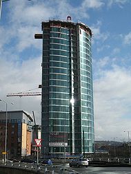
. Many of Sheffield's current and under construction major office premises and luxury apartments are located on the Ring Road.
Route
A61 road
The A61 is a major trunk road in England. It runs from Derby to Thirsk in North Yorkshire. From Derby, it heads north via Alfreton, Clay Cross, Chesterfield, Sheffield, Barnsley, Wakefield, Leeds, Harrogate and Ripon...
, coming in from Chesterfield
Chesterfield
Chesterfield is a market town and a borough of Derbyshire, England. It lies north of Derby, on a confluence of the rivers Rother and Hipper. Its population is 70,260 , making it Derbyshire's largest town...
as the Unstone-Dronfield Bypass, Chesterfield Road South, Meadowhead, Chesterfield Road
Chesterfield Road (Sheffield)
Chesterfield Road is a shopping street in Sheffield, England. It leads south from the suburb of Meersbrook to Woodseats, before becoming Meadowhead at the Abbey Lane junction, next to the Abbey pub. The road starts at Toll Bar bridge on the Meers Brook, the former boundary between Yorkshire and...
, London Road
London Road (Sheffield)
London Road is a shopping street in Sheffield, England. It leads south from the city centre near Moorfoot, parallel to Bramall Lane, through Sharrow, Highfield, Lowfield and Heeley, before becoming Chesterfield Road in Meersbrook next to The Crown Inn. Near Heeley Bridge was Heeley railway...
and Queens Road, joining the ring road itself at Suffolk Road. The A57
A57 road
The A57 is a major road in England. It runs east from Liverpool to Lincoln, via Warrington, Cadishead, Irlam, Patricroft, Eccles, Salford and Manchester, then through the Pennines over the Snake Pass , around the Ladybower Reservoir, through Sheffield and past Worksop...
(as The Parkway
Sheffield Parkway
The Sheffield Parkway is a major dual carriageway which runs between the City of Sheffield and junction 33 of the M1 in South Yorkshire, England. The 5.5 mile road was opened in 1974, and runs to the east of the City, connecting Park Square in the City centre with the inner ring road, outer ring...
) approaches Sheffield from the east (M1
M1 motorway
The M1 is a north–south motorway in England primarily connecting London to Leeds, where it joins the A1 near Aberford. While the M1 is considered to be the first inter-urban motorway to be completed in the United Kingdom, the first road to be built to motorway standard in the country was the...
jct 33) and arrives at Park Square
Park Square, Sheffield
Park Square is a major roundabout in Sheffield, England. The Sheffield Parkway, a major road from M1 Junction 33, terminates here. It is located next to Ponds Forge, a swimming pool and a venue for the games...
Roundabout, the start of the ring road. Travelling clockwise, the ring road consists of Sheaf Street, Sheaf Square
Sheaf Square
Sheaf Square is a municipal square lying immediately east of the city centre of Sheffield, England. The sides of the square are lined with major buildings: Sheffield railway station, the Showroom Cinema, Sheffield Science Park, the early nineteenth century Howard Hotel, in addition to the site of...
, Suffolk Road (anticlockwise) and Shoreham Street (clockwise), St Mary's Road, St Mary's Gate, Hannover Way, Upper Hannover Street, Netherthorpe Road and Hoyle Street, terminating at Shalesmoor, where the A61 turns north-west the Sheffield's northern suburbs and onto Barnsley
Barnsley
Barnsley is a town in South Yorkshire, England. It lies on the River Dearne, north of the city of Sheffield, south of Leeds and west of Doncaster. Barnsley is surrounded by several smaller settlements which together form the Metropolitan Borough of Barnsley, of which Barnsley is the largest and...
. The South portion of the inner ring road follows most of the course of the B6070
B roads in Zone 6 of the Great Britain numbering scheme
B roads are numbered routes in Great Britain of lesser importance than A roads. See the article Great Britain road numbering scheme for the rationale behind the numbers allocated.-Zone 6 :-Zone 6 :...
before the dual-carriageway sections were built. The B6070 now only applies to Granville Road and Rutland Road at either ends of the southern portion of the ring road.
Northern Relief Road
The Sheffield Northern Relief Road is the scheme closing a hole in the Inner Ring Road. Work began work in 1999, with phase 1 finished in 2000 as Cutlers Gate and was subsequently renamed late in 2008 as Derek Dooley Way, in honour of the late Sheffielder who played football for before breaking his leg and going on to perform a number of backroom roles across the city at . Derek Dooley Way named section runs from the ParkwaySheffield Parkway
The Sheffield Parkway is a major dual carriageway which runs between the City of Sheffield and junction 33 of the M1 in South Yorkshire, England. The 5.5 mile road was opened in 1974, and runs to the east of the City, connecting Park Square in the City centre with the inner ring road, outer ring...
to the Wicker
Wicker Arches
The Wicker Arches form a long railway viaduct across the Don Valley in the City of Sheffield, England. They take their name from the thoroughfare The Wicker, which passes through the main arch of the viaduct and was, until the completion of the Sheffield Parkway, the main route eastwards from the...
. In 2005 work started on the remainder, closing the gap from there to Shalesmoor and ended at the end of 2007. This section goes from Shalesmoor, down Moorfields, turning north at the junction with Gibraltar Street via a newly built road, meeting Corporation Street. It then crosses a new bridge before making its way to the Wicker through what was disused factories. There, at Junction 9, Bridgehouses, the road diverges, with part linking up to the Cutlers Gate section as described to join the Parkway where motorists may then turn right to continue on the ring road to Park Square and part heads underneath the viaduct and links to Spital Hill, Savile Street and Burngreave Road for connections to Attercliffe
Attercliffe
Attercliffe is an industrial suburb of northeast Sheffield, England on the south bank of the River Don.-History:The name Attercliffe can be traced back as far as an entry in the Domesday book -Ateclive- meaning at the cliffe, a small escarpment that lay alongside the River Don...
, Carbrook
Carbrook, South Yorkshire
Carbrook is an industrial area of Sheffield, South Yorkshire, England to the north-east of Brightside. The suburb is named for the Carr Brook, which ran through the area until the late eighteenth century....
and the northeast of Sheffield at Meadowhall
Meadowhall
Meadowhall is an indoor shopping centre in Sheffield, South Yorkshire, England. It lies three miles north east of Sheffield city centre and four miles from Rotherham town centre....
/Tinsley
Tinsley, South Yorkshire
Tinsley is a suburb of northeastern part of Sheffield, South Yorkshire. Its name derives from the Old English Tingas-Leah, which means 'Field of Council'...
. Nursery Street, the Wicker and Exchange Place
Riverside Exchange
Riverside Exchange is one of Sheffield's 11 designated City Centre Quarters, situated by the River Don. Its borders are West Bar, Coulston Street, Bridge Street, Castlegate, Exchange Place and the Parkway to its south, the Wicker Viaduct, Johnson Street, Spitalfields and Nursery Street to the...
were downgraded as part of the project.
Junctions
| Sheffield Inner Ring Road | ||
| left and right assume clockwise Clockwise Circular motion can occur in two possible directions. A clockwise motion is one that proceeds in the same direction as a clock's hands: from the top to the right, then down and then to the left, and back to the top... direction of travel roads which only allow access to, and not exit from the IRR have not been included, for example Milton Street (53.374861°N 1.479936°W |
||
| Left exits | Junction | Right exits |
| Parkway Sheffield Parkway The Sheffield Parkway is a major dual carriageway which runs between the City of Sheffield and junction 33 of the M1 in South Yorkshire, England. The 5.5 mile road was opened in 1974, and runs to the east of the City, connecting Park Square in the City centre with the inner ring road, outer ring... (for Darnall Darnall Darnall ward—which includes the districts of Attercliffe, Carbrook, Darnall, Tinsley, and parts of Handsworth—is one of the 28 electoral wards in City of Sheffield, South Yorkshire, England. It is located in the eastern part of the city and covers an area of 17.4 km2. The... , Handsworth Handsworth, South Yorkshire Handsworth is a suburb of south eastern Sheffield, in South Yorkshire, England. Handsworth has a population of approximately 15,000. It covers an overall area of approximately... and Woodhouse Woodhouse, South Yorkshire Woodhouse ward—which includes the district of Woodhouse and most of Handsworth—is one of the 28 electoral wards in City of Sheffield, England. It is located in the southeastern part of the city and covers an area of 7 km2. The population of this ward in 2001 was 17,900 people in... suburbs, Sheffield City Airport Sheffield City Airport Sheffield City Airport was a small airport located in Sheffield that is now closed. It was located in the Tinsley Park area of the city, near the M1 motorway and Sheffield Parkway, and opened in 1997... , Sheffield Business Park, Advanced Manufacturing Park Advanced Manufacturing Park The Advanced Manufacturing Park is a manufacturing technology park on the Rotherham/Sheffield border in Rotherham, South Yorkshire, facing the Sheffield Business Park across the Parkway... Outer Ring Road Sheffield Outer Ring Road Sheffield Outer Ring Road is one of two main routes circumventing Sheffield, a partial ring around Sheffield City Centre and its suburbs.It begins in Bradway as the B6054 Bradway Road, progressing anticlockwise as Greenhill Parkway, crossing the A61 Meadowhead/Chesterfield Road South into the A6102... and M1 M1 motorway The M1 is a north–south motorway in England primarily connecting London to Leeds, where it joins the A1 near Aberford. While the M1 is considered to be the first inter-urban motorway to be completed in the United Kingdom, the first road to be built to motorway standard in the country was the... ) |
1 (Cutlers Gate) |
No exit |
| Broad Street (for Cricket Inn Road, Wybourn Estate) Duke Street (for Manor Top and Manor Manor, South Yorkshire Manor Castle ward—which includes the districts of Claywood, Manor, Manor Park, Park Hill, and Wybourn—is one of the 28 electoral wards in City of Sheffield, England. It is located in the eastern part of the city and covers an area of 5.4 km2. The population of this ward in 2001 was... Estate) |
2 (Park Square Park Square, Sheffield Park Square is a major roundabout in Sheffield, England. The Sheffield Parkway, a major road from M1 Junction 33, terminates here. It is located next to Ponds Forge, a swimming pool and a venue for the games... ) |
Commercial Street (for City Centre Sheffield City Centre Sheffield City Centre—often just referred to as town—is a district of the City of Sheffield, and part of the Sheffield Central ward. It includes the area that is within a radius of roughly of Sheffield Cathedral, and is encircled by the Inner Ring Road—a circular route started in the late 1960s... , Ponds Forge Ponds Forge Ponds Forge International Sports Centre is a leisure complex in the City of Sheffield, England that contains an Olympic-sized swimming pool with seating for 2,600 spectators, family and kids pools, water slides and other sports facilities.-Brief history:... and Bus Station) Broad Street (for The Square) Exchange Place (for Castlegate Quarter Castlegate Quarter Castlegate is one of eleven Quarters in Sheffield's City Centre. It is now bound by Commercial Street and part of the High Street to the south , Exchange Place to the east, the road named Castlegate to the north, Angel Street and Snigg Hill to the west... , Furnival Road, Victoria Holiday Inn Sheffield Victoria Station Sheffield Victoria was the main railway station in Sheffield, South Yorkshire, England on the Great Central Railway, between Chesterfield and Penistone.-Early history:... and The Wicker Wicker Arches The Wicker Arches form a long railway viaduct across the Don Valley in the City of Sheffield, England. They take their name from the thoroughfare The Wicker, which passes through the main arch of the viaduct and was, until the completion of the Sheffield Parkway, the main route eastwards from the... south end) |
| Sheffield Midland Station Sheffield Midland station Sheffield station, formerly Pond Street and later Sheffield Midland, is a railway station in Sheffield, England and is the busiest station in South Yorkshire... and Sheaf Valley Quarter Sheaf Valley Quarter Sheaf Valley quarter is one of Sheffield's 11 designated City Centre Quarters, situated around the station and River Sheaf. Its borders are Commercial Street and a bowstring bridge to the north, the railway line to the east, Granville Road to the south Sheaf Valley quarter is one of Sheffield's 11... |
- | ' |
| Shrewsbury Road (for Manor Top) Granville Road Granville Road Granville Road, , is a road in Tsim Sha Tsui of Hong Kong. Located between Chatham Road and Nathan Road. The Road runs parallel to Kimberley Road, Cameron Road and Kimberley Street.- The name :... (for The Sheffield College Sheffield College Sheffield College is a further education college in Sheffield, England. It was formed by the merger of six FE colleges in 1993. The main centres are Sheffield City College , Hillsborough College and Norton College... ) Queens Road for routes south Derbyshire Derbyshire is a county in the East Midlands of England. A substantial portion of the Peak District National Park lies within Derbyshire. The northern part of Derbyshire overlaps with the Pennines, a famous chain of hills and mountains. The county contains within its boundary of approx... to Chesterfield Chesterfield Chesterfield is a market town and a borough of Derbyshire, England. It lies north of Derby, on a confluence of the rivers Rother and Hipper. Its population is 70,260 , making it Derbyshire's largest town... Shoreham Street (for Bramall Lane football ground Bramall Lane -Cricket at the Lane:Bramall Lane opened as a cricket ground in 1855, having been leased by Michael Ellison from the Duke of Norfolk at an annual rent of £70. The site was then away from the town's industrial area, and relatively free from smoke. It was built to host the matches of local cricket... and routes south to Chesterfield) |
3 (Granville Square Granville Square Granville Square is a prominent tower located at 200 Granville Street in Downtown Vancouver's Financial District. Completed in 1973, it stands at 142 m or 30 storeys high, making it one of the tallest buildings in the city... ) |
Shoreham Street (for BBC Yorkshire BBC Yorkshire BBC Yorkshire is one of the English regions of the BBC. It was formed from the division of the former BBC North region into BBC Yorkshire and BBC Yorkshire and Lincolnshire, based in Hull.-Television:... 's Radio Sheffield BBC Radio Sheffield BBC Radio Sheffield is the BBC Local Radio service for English metropolitan county of South Yorkshire and North Derbyshire. This includes the city of Sheffield, plus Doncaster, Barnsley, Rotherham, Chesterfield and surrounding areas. It was the BBC local radio station, beginning on 15 November 1967... HQ Headquarters Headquarters denotes the location where most, if not all, of the important functions of an organization are coordinated. In the United States, the corporate headquarters represents the entity at the center or the top of a corporation taking full responsibility managing all business activities... the Leadmill Leadmill The Leadmill is a live music venue and nightclub on Leadmill Road, Sheffield, England lying on the south-east edge of the city centre. It opened in 1980, in what despite its name was a former flour mill... and CIQ Cultural Industries Quarter The Cultural Industries Quarter is a district in the city centre of Sheffield, England, and one of the eleven Quarters designated in the 1994 City Centre Strategy... ) |
| Mary Streetac (for CIQ Cultural Industries Quarter The Cultural Industries Quarter is a district in the city centre of Sheffield, England, and one of the eleven Quarters designated in the 1994 City Centre Strategy... ) |
- | no exit |
| Eyre Street (for CIQ, the Moor The Moor The Moor is a primary pedestrianised thoroughfare and one of the main shopping streets of Sheffield, England. Along its length lie some of the most popular department stores and it is seen as one of the primary retail cores of the city centre... parking, Heart of the City Parking, The Moor Quarter The Moor Quarter The Moor Quarter is one of Sheffield's eleven designated quarters and based around and named for the The Moor. It is bound by Furnival gate in the north-east, Eyre Street in the south-east, St. Mary's gate to the south and Moore Street and Charter Row to the north-west.It is primarily a retail... , and Town Hall Sheffield Town Hall Sheffield Town Hall is a building in the City of Sheffield, England. The building is used by Sheffield City Council, and also contains a publicly displayed collection of silverware. The current building, Sheffield's fourth town hall, is located on Pinstone Street. It was designed by the... ) |
4 (Bramall Lane Bramall Lane -Cricket at the Lane:Bramall Lane opened as a cricket ground in 1855, having been leased by Michael Ellison from the Duke of Norfolk at an annual rent of £70. The site was then away from the town's industrial area, and relatively free from smoke. It was built to host the matches of local cricket... ) |
Bramall Lane (for Bramall Lane Football ground Bramall Lane -Cricket at the Lane:Bramall Lane opened as a cricket ground in 1855, having been leased by Michael Ellison from the Duke of Norfolk at an annual rent of £70. The site was then away from the town's industrial area, and relatively free from smoke. It was built to host the matches of local cricket... , Heeley Mosque, Gleadless Valley Gleadless Valley Gleadless Valley ward—which includes the districts of Gleadless Valley , Heeley, Lowfield, and Meersbrook—is one of the 28 electoral wards in City of Sheffield, England. It is located in the southern part of the city and covers an area of 4.5 km2... and routes south to Chesterfield) |
| London Road London Road (Sheffield) London Road is a shopping street in Sheffield, England. It leads south from the city centre near Moorfoot, parallel to Bramall Lane, through Sharrow, Highfield, Lowfield and Heeley, before becoming Chesterfield Road in Meersbrook next to The Crown Inn. Near Heeley Bridge was Heeley railway... c (for London Road Shops and restaurants and unofficial Chinatown Chinatown A Chinatown is an ethnic enclave of overseas Chinese people, although it is often generalized to include various Southeast Asian people. Chinatowns exist throughout the world, including East Asia, Southeast Asia, the Americas, Australasia, and Europe. Binondo's Chinatown located in Manila,... , Abbeydale Road Abbeydale Road Abbeydale Road and Abbeydale Road South is a road in Sheffield. It leads south-west from the suburb of Highfield to the railway bridge over the Dore and Chinley railway, before becoming Baslow Road. The road begins at a junction with London Road near the former Royal Hotel public house.The road... restaurants and Meersbrook Park Meersbrook Park Meersbrook Park is set on a steep hillside in Meersbrook, Sheffield, United Kingdom, and offers a stunning panoramic view over central Sheffield to the north. Within the park are two historic buildings: Bishops' House is one of the oldest buildings in Sheffield and is open as a museum, and... ) |
- | South Lane (for the Moor and DWP Department for Work and Pensions The Department for Work and Pensions is the largest government department in the United Kingdom, created on June 8, 2001 from the merger of the employment part of the Department for Education and Employment and the Department of Social Security and headed by the Secretary of State for Work and... , DfES and Home Office Home Office The Home Office is the United Kingdom government department responsible for immigration control, security, and order. As such it is responsible for the police, UK Border Agency, and the Security Service . It is also in charge of government policy on security-related issues such as drugs,... in the Moorfoot Building Moorfoot Building The Moorfoot Building is a large office building in Sheffield, South Yorkshire, England, in the form of a step pyramid. It is located at the foot of The Moor , close to the Sheffield Inner Ring Road. Before its construction, The Moor continued across St Mary's Gate onto London Road... ) |
| Ecclesall Road Ecclesall Road |thumb|200px|right|Ecclesall Road South, which runs through a large part of the Hallam Constituency, the second wealthiest in the UK.Ecclesall Road is a road in Sheffield that runs for about 3.5 miles south-west from Sheffield's city centre under the number A625... (for shopping, boutiques, restaurants and Hunter's Bar Hunter's Bar Hunter's Bar is a roundabout and former toll bar on Ecclesall Road in south-west Sheffield and was active until the late 19th century. The name also attaches to the area surrounding Hunter's Bar roundabout at the intersection of Ecclesall Road, Brocco Bank, Sharrow Vale Road and Junction Road. The... , plus routes to the south-western suburbs of Dore Dore Dore is a village in South Yorkshire, England. The village lies on a hill above the River Sheaf, and until 1934 was part of Derbyshire, but it is now a suburb of Sheffield. It is served by Dore and Totley railway station on the Hope Valley Line... , Totley Totley Totley is a suburb on the extreme southwest of the City of Sheffield, in South Yorkshire, England. Lying in the historic county boundaries of Derbyshire, Totley was amalgamated into the city of Sheffield in 1935, and is today part of the Dore and Totley electoral ward in the city, though it remains... and Ecclesall Ecclesall Ecclesall Ward—which includes the neighbourhoods of Bents Green, Ecclesall, Greystones, Millhouses, and Ringinglow—is one of the 28 electoral wards in City of Sheffield, England. It is located in the southwestern part of the city and covers an area of 9.4 km2. The population of... and the Peak District Peak District The Peak District is an upland area in central and northern England, lying mainly in northern Derbyshire, but also covering parts of Cheshire, Greater Manchester, Staffordshire, and South and West Yorkshire.... ) |
5 (Moore Street) |
Moore Street (for The Moor Quarter, Devonshire Quarter Devonshire Quarter The Devonshire Quarter is an area in the centre of Sheffield, England. It is based around the Division Street and Devonshire Street shopping areas, known for their small independent shops and variety of pubs and bars... , Heart of the City, BT BT Group BT Group plc is a global telecommunications services company headquartered in London, United Kingdom. It is one of the largest telecommunications services companies in the world and has operations in more than 170 countries. Through its BT Global Services division it is a major supplier of... tower, Grosvenor Hotel, pubs and bars) |
| Broomhall Streetc (for Broomhall and the Groves The Groves The Groves is an area of York, England, covering the area just outside the city centre between Huntington Road and Haxby Road. It consists largely of close-knit terraces, the majority of which date from before World War I.... suburbs) |
- | no exit |
| Broomspring Lanec (for Broomhall) | - | Gell Streetac (for West End West End, Sheffield The West End is a loosely-defined area of Sheffield, consisting of part of the City Centre, in addition to some of the western suburbs. The term has been in use for at least 150 years.- Modern Usage :... parking, Devonshire Quarter |
| no exit | - | Leavygreave Road (for University St. George's Campus) |
| Western Bank (for University University of Sheffield The University of Sheffield is a research university based in the city of Sheffield in South Yorkshire, England. It is one of the original 'red brick' universities and is a member of the Russell Group of leading research intensive universities... West Campus, Children's Hospital Sheffield Children's Hospital The Sheffield Children's Hospital is part of and the headquarters of the Sheffield Children's NHS Foundation Trust in Broomhill, Sheffield, South Yorkshire, England... +A&E Emergency department An emergency department , also known as accident & emergency , emergency room , emergency ward , or casualty department is a medical treatment facility specialising in acute care of patients who present without prior appointment, either by their own means or by ambulance... , Central Sheffield University Hospitals, Weston Park Weston Park Weston Park is a country house in Weston-under-Lizard, Staffordshire, England, set in more than of park landscaped by Capability Brown. The park is located north-west of Wolverhampton, and north-east of Telford, close to the border with Shropshire... and its Museum) Bolsover Street (for Crookesmoor and Walkley Walkley Walkley is an electoral ward in Sheffield, South Yorkshire, England.Walkley ward—which includes the districts of Netherthorpe, Upperthorpe, Walkley and parts of Neepsend—is one of the 28 electoral wards in City of Sheffield, England. It is located in the northwestern part of the city... suburbs) and Crookes Valley Park Crookes Valley Park Crookes Valley Park is an area of public parkland in the Crookesmoor area of the City of Sheffield in South Yorkshire, England. The park lies just under two kilometres west of the City centre at... |
6 (University Square) |
Broad Lane (for St. George's Quarter, University University of Sheffield The University of Sheffield is a research university based in the city of Sheffield in South Yorkshire, England. It is one of the original 'red brick' universities and is a member of the Russell Group of leading research intensive universities... St. George's Campus and Cathedral Quarter) |
| Morpeth Street | - | no exit |
| Meadow Street (for Upperthorpe and Infirmary Road shops) | - | Meadow Street (for St. Vincent's Quarter St. Vincent's Quarter St Vincent's Quarter is one of Sheffield's eleven designated quarters and based around and named after St Vincent's Church. Primarily an office and industrial location, its regeneration has increased rapidly over the past few years, with the new Metier residential block and Velocity Village office... ) |
| no exit | - | Doncaster Street (for St. Vincent's Quarter) |
| Penistone Road (for Hillsborough Hillsborough, South Yorkshire Hillsborough is an electoral ward which includes the districts of Malin Bridge, Owlerton, Wadsley and Wisewood. It is one of the 28 electoral wards in City of Sheffield, England. It is located in the northwestern part of the city and covers an area of 4.6 km2... , Grenoside Grenoside Grenoside is a suburb of Sheffield, South Yorkshire, England.-History:The name Grenoside is derived from the language of the Anglo-Saxons. The name Grenoside, which was first recorded in the thirteenth century as Gravenhou, is made up of the different elements. Gren from the Old English graefan... , Ecclesfield Ecclesfield Ecclesfield is a suburb and civil parish in the City of Sheffield in South Yorkshire, England, about north of Sheffield City Centre. At the 2001 census the civil parish— which also includes the Sheffield suburbs of Chapeltown, Grenoside, High Green, and formerly Thorpe Hesley —had a population... and Chapeltown Chapeltown, South Yorkshire Chapeltown is in northern Sheffield, in South Yorkshire, England. It forms part of the Ecclesfield civil parish. There is a wide variety of shops, pubs and restaurants as well as a supermarket... suburbs, Hillsborough Hillsborough, South Yorkshire Hillsborough is an electoral ward which includes the districts of Malin Bridge, Owlerton, Wadsley and Wisewood. It is one of the 28 electoral wards in City of Sheffield, England. It is located in the northwestern part of the city and covers an area of 4.6 km2... shops, Hillsborough - Sheffield Wednesday FC Hillsborough Stadium Hillsborough Stadium is the home of Sheffield Wednesday football club, Sheffield, England. Football has been played at the ground since it was opened on 2 September 1899, when Wednesday moved from their original ground at Olive Grove. Today it is a 39,812 capacity all-seater stadium, making it the... and Owlerton Owlerton Stadium Owlerton Stadium, sometimes referred to as Sheffield Sports Stadium, is a greyhound racing track in Owlerton near Hillsborough in Sheffield, South Yorkshire, England. The stadium is also home to the Sheffield Tigers Speedway team and hosts BriSCA Formula One stock car racing events. It is operated... stadia, Northern General Hospital Northern General Hospital The Northern General Hospital is a large teaching hospital in Sheffield, England. It hosts most major departments, including a busy Accident and Emergency for adults... and routes north to Barnsley Barnsley Barnsley is a town in South Yorkshire, England. It lies on the River Dearne, north of the city of Sheffield, south of Leeds and west of Doncaster. Barnsley is surrounded by several smaller settlements which together form the Metropolitan Borough of Barnsley, of which Barnsley is the largest and... |
7 (Shalesmoor) |
no exit |
| Ebenezer Streetac (for Neepsend Neepsend Neepsend is a suburb of the city of Sheffield, it stands just north east of the city centre. The main area of Neepsend covers the flood plain of the River Don from Lady's Bridge at the Wicker up to Hillfoot Bridge... and Kelham Island Kelham Island Quarter Kelham Island is one of Sheffield's eleven designated Quarters. Formerly an industrial area, the island itself was created by the building of a goit, or mill race, fed from the River Don to serve the water wheels powering the workshops of the areas' industrial heyday... ) |
- | Shepherd Streetc (for Kelham Island and St. Vincent's Quarter residential areas) |
| Russell Streetac | - | Gibraltar Streetc |
| Cotton Mill Row (for Alma Street, Fat Cat Pub and Kelham Island Industrial Museum Kelham Island Museum The Kelham Island Museum is an industrial museum on Alma Street, alongside the River Don, in the centre of Sheffield, England. It was opened in 1982.-The site:... ) |
8 (Corporation Street) |
Plum Lane (for Riverside Quarter, River Don and Castlemore) Corporation Street (for West Bar, Law Courts and Paradise Square Paradise Square Paradise Square is a Georgian square in the City of Sheffield, England. Located to the northwest of Sheffield Cathedral, the square is set on a slope and was formerly used for public meetings.-History:... ) |
| Alma Street (for Fat Cat Pub and Kelham Island Goit) Mowbray Street (for Neepsend) Chatham Street (for Residential areas Neepsend and Burngreave Burngreave Burngreave ward—which includes the districts of Burngreave, Fir Vale, Grimesthorpe, Pitsmoor, and Shirecliffe—is one of the 28 electoral wards in City of Sheffield, England. It is located in the northern part of the city and covers an area of 7.3 km2. The population of this ward in... ) |
9 (Bridgehouses) |
Bridge Street (for Castlegate) Nursery Street (for Spitalfield and riverside) |
| Spital Hill (for Burngreave) Saville Street (for Lower Don Valley Lower Don Valley The Lower Don Valley, or historically the East End of Sheffield, is the mainly industrial north-east quarter of Sheffield, England. Based around the River Don it encompasses the areas of Attercliffe, Brightside, Darnall, Tinsley and Wincobank.... inc Valley Centertainment Valley Centertainment Valley Centertainment is a leisure and entertainment complex in the Don Valley in Sheffield, South Yorkshire, England. It was built on land previously occupied by steel mills near what is now Meadowhall and the Sheffield Arena... , Sheffield Arena) |
10 (Spital Hill) |
no exit |
| c - clockwise travel only. ac - anticlockwise travel only | ||
For an explanation of the Quarters, see Sheffield City Centre's Quarters