
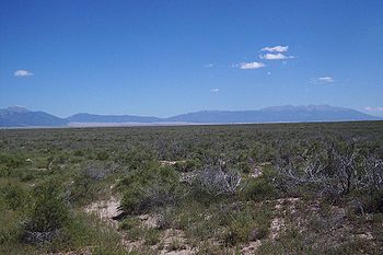
San Luis Valley
Encyclopedia

U.S. state
A U.S. state is any one of the 50 federated states of the United States of America that share sovereignty with the federal government. Because of this shared sovereignty, an American is a citizen both of the federal entity and of his or her state of domicile. Four states use the official title of...
s of Colorado
Colorado
Colorado is a U.S. state that encompasses much of the Rocky Mountains as well as the northeastern portion of the Colorado Plateau and the western edge of the Great Plains...
and New Mexico
New Mexico
New Mexico is a state located in the southwest and western regions of the United States. New Mexico is also usually considered one of the Mountain States. With a population density of 16 per square mile, New Mexico is the sixth-most sparsely inhabited U.S...
covering approximately 8000 square miles (20,719.9 km²) and sitting at an average elevation of 7500 feet (2,286 m) above sea level. The valley sits atop the Rio Grande Rift
Rio Grande Rift
The Rio Grande Rift is a north-trending continental rift zone. It separates the Colorado Plateau in the west from the interior of the North American craton on the east. The rift extends from central Colorado in the north to the state of Chihuahua, Mexico in the south. The rift zone consists of four...
and is drained to the south by the Rio Grande River, which rises in the San Juan Mountains
San Juan Mountains
The San Juan Mountains are a high and rugged mountain range in the Rocky Mountains in southwestern Colorado. The area is highly mineralized and figured in the gold and silver mining industry of early Colorado. Major towns, all old mining camps, include Creede, Lake City, Silverton, Ouray, and...
to the west of the valley and flows south into New Mexico. The valley is approximately 122 miles (196 km) long and 74 miles (119 km) wide, extending from the Continental Divide
Continental Divide
The Continental Divide of the Americas, or merely the Continental Gulf of Division or Great Divide, is the name given to the principal, and largely mountainous, hydrological divide of the Americas that separates the watersheds that drain into the Pacific Ocean from those river systems that drain...
on the northwest rim into New Mexico on the south. The San Luis Valley receives little precipitation
Precipitation (meteorology)
In meteorology, precipitation In meteorology, precipitation In meteorology, precipitation (also known as one of the classes of hydrometeors, which are atmospheric water phenomena is any product of the condensation of atmospheric water vapor that falls under gravity. The main forms of precipitation...
and is made up of desert
Desert
A desert is a landscape or region that receives an extremely low amount of precipitation, less than enough to support growth of most plants. Most deserts have an average annual precipitation of less than...
lands, but the temperatures can be very comfortable in the summer and very cold on winter nights.
Geography
The San Luis Valley is the broad, generally flat, valley at the headwaters of the Rio Grande in north central New Mexico and south central Colorado. There is no clear southern boundary but the term is generally used to include the San Luis Hills of southern Colorado and the Taos Plateau of northern New Mexico. About 50 miles from east to west and about 150 miles from north to south, the valley is bounded on the east by the Sangre de Cristo MountainsSangre de Cristo Mountains
The Sangre de Cristo Mountains are the southernmost subrange of the Rocky Mountains. They are located in southern Colorado and northern New Mexico in the United States...
and on the west by the San Juan Mountains
San Juan Mountains
The San Juan Mountains are a high and rugged mountain range in the Rocky Mountains in southwestern Colorado. The area is highly mineralized and figured in the gold and silver mining industry of early Colorado. Major towns, all old mining camps, include Creede, Lake City, Silverton, Ouray, and...
.
Within Colorado the San Luis Valley is generally considered to comprise six Colorado counties: Saguache
Saguache County, Colorado
Saguache County is the seventh most extensive of the 64 counties of the state of Colorado of the United States. The county name comes from a Ute language word meaning “blue earth” or “water at blue earth”. The county population was 5,917 at U.S. Census 2000...
, Alamosa
Alamosa County, Colorado
Alamosa County is one of the 64 counties of the state of Colorado of the United States. The county name is the Spanish language word for a "grove of cottonwood trees." The county population was 14,966 at U.S. Census 2000...
, Rio Grande
Rio Grande County, Colorado
Rio Grande County is one of the 64 counties of the State of Colorado of the United States. The county is named for the Rio Grande , which flows through the county. The county population was 12,413 at U.S. Census 2000...
, Conejos
Conejos County, Colorado
Conejos County is one of the 64 counties of the State of Colorado in the United States. The county population was 8,400 at U.S. Census 2000. The county seat is the unincorporated town of Conejos.-History:...
, Costilla
Costilla County, Colorado
Costilla County is the ninth least populous of the 64 counties in the state of Colorado of the United States. The county population was 3,663 at U.S. Census 2000. The county seat is San Luis, the oldest town in Colorado.- History :...
and Mineral
Mineral County, Colorado
Mineral County is the second least populous of the 64 counties of the State of Colorado of the United States. The county was named for the many valuable minerals found in the mountains and streams of the area. The county population was 831 at U.S. Census 2000...
. The principal towns are: Alamosa
Alamosa, Colorado
The city of Alamosa is a Home Rule Municipality that is the county seat and the most populous city of Alamosa County, Colorado, United States. The United States Census Bureau estimates that the city population was 8,682 in 2005...
, Monte Vista
Monte Vista, Colorado
The City of Monte Vista is a Home Rule Municipality that is the most populous city in Rio Grande County, Colorado, United States. The population was 4,529 at the 2000 census.-Geography:...
, Del Norte
Del Norte, Colorado
The Town of Del Norte is a Statutory Town in and the county seat of Rio Grande County, Colorado, United States. The town population was 1,705 at the 2000 census.-Geography:Del Norte is located at ....
, South Fork
South Fork, Colorado
South Fork is a Statutory Town in Rio Grande County, Colorado, United States. The population was 604 at the 2000 census.-Geography:South Fork is located at .According to the United States Census Bureau, the town has a total area of , all of it land....
, Creede
Creede, Colorado
The historic town of Creede is a Statutory Town that is the county seat of, and the only incorporated municipality in, Mineral County, Colorado, United States. The town population was 377 at the U.S. Census 2000.-History:...
, Saguache
Saguache, Colorado
The historic town of Saguache is a Statutory Town that is the county seat and most populous town of Saguache County, Colorado, United States. The population was 578 at the U.S. Census 2000.-Name:...
, Center
Center, Colorado
The town of Center is a Statutory Town in Rio Grande and Saguache Counties in the U.S. state of Colorado. The population was 2,392 at the 2000 census.Leach Airport is located 4 miles east and 3 miles north of town, at County Road 53 and County Road C...
, Fort Garland
Fort Garland, Colorado
Fort Garland is a census-designated place in Costilla County, Colorado, United States. The population was 433 at the 2010 census. The Fort Garland Post Office has the ZIP Code 81133.-General Information:...
, San Luis
San Luis, Colorado
The Town of San Luis is a statutory town that is the county seat and the most populous town of Costilla County, Colorado, United States. The population was 739 at the 2000 census.-History:...
, Antonito
Antonito, Colorado
The Town of Antonito is a statutory town located in Conejos County, Colorado, United States. As of the 2000 census, the town's population was 873.-Geography:...
, La Jara
La Jara, Colorado
La Jara is a Statutory Town in Conejos County, Colorado, United States. The population was 877 at the 2000 census.-Geography:La Jara is located at ....
, Capulin
Capulin, Colorado
Capulin is a census-designated place and U.S. Post Office in Conejos County, Colorado, United States. The ZIP Code of the Capulin Post Office is 81124. The population as of the 2010 Census was 200.-History:...
, Manassa
Manassa, Colorado
The Town of Manassa is a Statutory Town that is the most populous town in Conejos County, Colorado, United States. With a population of 1,042 at the 2000 census, Manassa is the largest community in Conejos County....
, Sanford
Sanford, Colorado
Sanford is a Statutory Town in Conejos County, Colorado, United States. The population was 817 at the 2000 census.-Geography:Sanford is located at ....
, Crestone
Crestone, Colorado
Crestone is a statutory town in Saguache County in Southwestern Colorado, United States. The population was 73 at the 2000 census. It is a small village at the foot of the western slope of the Sangre de Cristo Range, in the northern part of the San Luis Valley. Crestone was a small mining town, but...
, Villa Grove
Villa Grove, Colorado
Villa Grove is an unincorporated town and a U.S. Post Office located in Saguache County, Colorado, United States. The Villa Grove Post Office has the ZIP Code 81155.- History :...
, Hooper
Hooper, Colorado
Hooper is a Statutory Town located in the San Luis Valley in Alamosa County, Colorado, United States. The population was 123 at the 2000 census.Nearby points of interest include the Great Sand Dunes National Park, and Crestone, Colorado.-Geography:...
, Mosca
Mosca, Colorado
Mosca is an unincorporated town and a U.S. Post Office in Alamosa County, Colorado, United States. It was named for the nearby Mosca Pass, which was named for the Spanish explorer, Luis de Moscoso de Alvarado...
, San Acacio
San Acacio, Colorado
San Acacio is a census-designated place in Costilla County, Colorado, United States. The U.S. Post Office at Sanford now serves San Acacio postal addresses.-History:*Old San AcacioThe original San Acacio was founded in 1853...
and a number of smaller locations. A few other counties of Colorado have some land in the Rio Grande Basin including Archuleta County, Hinsdale County and San Juan County
San Juan County, Colorado
San Juan County is the least populous of the 64 counties of the state of Colorado in the United States. The county name is the Spanish language name for “Saint John”, the name Spanish explorers gave to a river and the mountain range in the area. The county population was 558 at U.S. Census 2000...
.
Blanca Peak
Blanca Peak is the highest peak of the Sierra Blanca Massif at the southern tip of the Sangre de Cristo Mountains in the U.S. State of Colorado. It is the fourth highest peak of the Rocky Mountains, and the eighth highest peak in the contiguous United States....
is prominent in the Sierra Blanca at the southern end of the northernmost section of the mountains, which is known as the Sangre de Cristo Range
Sangre de Cristo Range
The Sangre de Cristo Range, called the East Range locally in the San Luis Valley, is a narrow mountain range of the Rocky Mountains running north and south along the east side of the Rio Grande Rift in southern Colorado in the United States...
. There are several passes, with elevations between 9000 and 10000 ft (2,743.2 and 3,048 ), giving access to the valley. North La Veta Pass
North La Veta Pass
North La Veta Pass is a elevation mountain pass in the Sangre de Cristo Mountains in south central Colorado in the United States....
, through the Sangre de Cristo Mountains, is used by US Highway 160
U.S. Route 160
U.S. Route 160 is a 1,465 mile long east–west United States highway in the Midwestern United States. The western terminus of the route is at U.S. Route 89 five miles west of Tuba City, Arizona. The eastern terminus is at U.S...
and by the San Luis and Rio Grande Railroad
San Luis and Rio Grande Railroad
The San Luis and Rio Grande Railroad is a class III railroad operating in Colorado.The SLRG began operations in 2003 using 154 miles of former Denver and Rio Grande Western Railroad tracks on three lines radiating from Alamosa, Colorado. The SLRG operates an eclectic variety of equipment from the...
(formerly a branch of the Denver & Rio Grande Western) tracks. Other passes used historically were Medano, Mosca and Sangre de Cristo Passes.
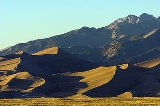
The Great Sand Dunes
Great Sand Dunes National Park and Preserve
-Other features:The park also contains alpine lakes and tundra, six peaks over 13,000 feet in elevation, ancient spruce and pine forests, large stands of aspen and cottonwood, grasslands, and wetlands — all habitat for diverse wildlife and plant species.One of the most unusual features of...
is a famous feature of the valley. It lies directly to the west of the Sangre de Cristo Mountains. The dunes can reach 750 feet (228.6 m) high. The Great Sands Dunes National Park and Preserve is now in place to protect both the dunes and the numerous archeological sites found in the area. The natural valley aquifer is close to the surface in this part of the valley, and helps with maintenance of water levels in the San Luis Lakes, just to the west of the sand dunes.
Elevation rises as you go north in the valley to Poncha Pass
Poncha Pass
Poncha Pass is a mountain pass in South-Central Colorado . It lies between the San Luis Valley to the south and the valley of the Arkansas River to the north, and is one of the lowest mountain passes in the state . It is in the saddle between the Sangre de Cristo Range, lying to the southeast, and...
, used now by US Highway 285
U.S. Route 285
U.S. Route 285 is a north–south United States highway, running 845 miles through the states of Texas, New Mexico and Colorado. The highway's northern terminus is in Denver, Colorado, at exit 201 on Interstate 25. Its southern terminus is in Sanderson, Texas at an intersection with U.S....
and historically by the narrow gauge tracks of the Denver and Rio Grande Railroad. Otto Mears
Otto Mears
Otto Mears was a famous Colorado railroad builder and entrepreneur who played a major role in the early development of southwestern Colorado....
, then of Saguache, built and operated an historic toll road
Toll road
A toll road is a privately or publicly built road for which a driver pays a toll for use. Structures for which tolls are charged include toll bridges and toll tunnels. Non-toll roads are financed using other sources of revenue, most typically fuel tax or general tax funds...
over Poncha Pass
Poncha Pass
Poncha Pass is a mountain pass in South-Central Colorado . It lies between the San Luis Valley to the south and the valley of the Arkansas River to the north, and is one of the lowest mountain passes in the state . It is in the saddle between the Sangre de Cristo Range, lying to the southeast, and...
at the north end of the valley into the San Luis Valley during Colorado's 19th century mining era when the valley was the gateway to the San Juan and Gunnison country and the Ute agency was in the mountains west of Saguache.
Cumbres Pass
Cumbres Pass
Cumbres Pass, elevation , is a mountain pass in the San Juan Mountains of Colorado. The pass is traversed by State Highway 17 and the Cumbres and Toltec Scenic Railroad. The highway has a moderate 5.8% approach on the north side and a gentler, 4% approach on the south side...
is a 10,015 ft. pass between Antonito, Colorado
Antonito, Colorado
The Town of Antonito is a statutory town located in Conejos County, Colorado, United States. As of the 2000 census, the town's population was 873.-Geography:...
and Chama, New Mexico
Chama, New Mexico
Chama is a village in Rio Arriba County, New Mexico, United States. The population was 1,199 at the 2000 census. It is a small village, but tourism is starting to help the town's economy .-Geography:...
. The pass is traversed by State Highway 17 and the Cumbres and Toltec Scenic Railroad
Cumbres and Toltec Scenic Railroad
The Cumbres & Toltec Scenic Railroad is a narrow gauge heritage railroad running between Chama, New Mexico and Antonito, Colorado. It runs over the Cumbres Pass, the highest point on a US passenger railway....
. From the headwaters of the Rio Grande Wolf Creek Pass
Wolf Creek Pass
Wolf Creek Pass is a high mountain pass on the Continental Divide, in the San Juan Mountains of Colorado. It is the route through which U.S. Highway 160 passes from the San Luis Valley into southwest Colorado on its way to New Mexico and Arizona. The pass is notable as inspiration of a C. W....
is the route of U.S. Highway 160 between Del Norte, Colorado
Del Norte, Colorado
The Town of Del Norte is a Statutory Town in and the county seat of Rio Grande County, Colorado, United States. The town population was 1,705 at the 2000 census.-Geography:Del Norte is located at ....
and Pagosa Springs, Colorado
Pagosa Springs, Colorado
Pagosa Springs is a Home Rule Municipality that is the county seat of, and the only incorporated municipality in, Archuleta County, Colorado, United States. The population was 1,591 at the 2000 census...
, while Slumgullion Pass
Slumgullion Pass
Slumgullion Pass, elevation , is a mountain pass in Colorado traversed by State Highway 149 east of Lake City. The north side has the steepest grade of any continuously paved road in Colorado , but the pass does not close often in winter because snowplows clear the route regularly during this season...
is the route of State Highway 149 between U.S. Highway 160 and Lake City, Colorado
Lake City, Colorado
The Town of Lake City is a Statutory Town that is the county seat of, and the only incorporated municipality in, Hinsdale County, Colorado, United States. The town population was 375 at the U.S. Census 2000...
. Stony Pass, sometimes spelled Stoney Pass, an historic wagon road to the mining camps of the San Juans
San Juan Mountains
The San Juan Mountains are a high and rugged mountain range in the Rocky Mountains in southwestern Colorado. The area is highly mineralized and figured in the gold and silver mining industry of early Colorado. Major towns, all old mining camps, include Creede, Lake City, Silverton, Ouray, and...
, is now a jeep trail
Jeep trail
Roads that are only suitable for off-road vehicles are often called jeep trails.The most famous is the Rubicon Trail located near Lake Tahoe in California. The so-called "Jeep Trail Capital of the World," however, is Ouray, Colorado...
. At the north end of the valley, North Pass
North Pass
North Pass is a mountain pass over the Continental Divide in Colorado traversed by state route 114 between Saguache, Colorado and Gunnison, Colorado. It is an all-weather paved road, but, as of 2011, there are no snow plows operating between 7 PM and 7 AM....
is the route of State Highway 114 between Saguache, Colorado
Saguache, Colorado
The historic town of Saguache is a Statutory Town that is the county seat and most populous town of Saguache County, Colorado, United States. The population was 578 at the U.S. Census 2000.-Name:...
and Gunnison, Colorado
Gunnison, Colorado
The historic City of Gunnison, a Home Rule Municipality, is the county seat and the most populous city of Gunnison County, Colorado, United States. As of the 2010 census, the city had a population of 5,854. It was named in honor of John W...
, bypassing the original route over Cochetopa Pass
Cochetopa Pass
Cochetopa Pass is a mountain pass in Colorado. It lies between the city of Gunnison and the town of Saguache. It lies on the Continental Divide, which separates the Gunnison and Rio Grande National Forests...
, now a county road.
The Rio Grande follows a course through the southern valley from Del Norte southeastward via Alamosa to New Mexico. South of Alamosa it is joined by several streams from the west including the Alamosa River
Alamosa River
The Alamosa River is a river in the southern part of the U.S. state of Colorado. It is about long, flowing roughly east through the San Luis Valley. Its watershed comprises about .The river's name means "shaded with cottonwoods" in Spanish....
and the Conejos River
Conejos River
The Conejos River is a tributary of the Rio Grande, approximately long, in south-central Colorado in the United States. It drains a scenic area of the eastern San Juan Mountains west of the San Luis Valley.-Description:...
and Culebra Creek from the east. Most of the northern valley is a endorheic basin called the Closed Basin. Generally, within the Closed Basin the major streams such as Saguache Creek
Saguache Creek
Saguache Creek is a stream in Saguache County, Colorado. The creek flows from the confluence of its North and Middle forks before joining San Luis Creek. Saguache Creek is in the San Luis Closed Basin, the largest endorheic basin in Colorado....
, San Luis Creek
San Luis Creek (Colorado)
San Luis Creek is a stream that flows from a source near Poncha Pass in Saguache County, Colorado to San Luis Lake adjacent to Great Sand Dunes National Park. San Luis Lake is the sink of the San Luis Closed Basin, the largest endorheic basin in Colorado....
, and the streams from the west face of the Sangre de Cristos flow only a short distance onto the valley floor as surface streams. Only in very wet years, perhaps every 20 years, does the stream system in the basin flow as a connected unit into San Luis Lake at the low point of the Closed Basis southeast of the Great Sand Dunes.
Geology
The San Luis Valley, contains an alluvial basinAlluvium
Alluvium is loose, unconsolidated soil or sediments, eroded, deposited, and reshaped by water in some form in a non-marine setting. Alluvium is typically made up of a variety of materials, including fine particles of silt and clay and larger particles of sand and gravel...
, the Alamosa Basin, which lies at the north end of the Rio Grande rift
Rio Grande Rift
The Rio Grande Rift is a north-trending continental rift zone. It separates the Colorado Plateau in the west from the interior of the North American craton on the east. The rift extends from central Colorado in the north to the state of Chihuahua, Mexico in the south. The rift zone consists of four...
. Deeper alluvial strata, overlying Precambrian
Precambrian
The Precambrian is the name which describes the large span of time in Earth's history before the current Phanerozoic Eon, and is a Supereon divided into several eons of the geologic time scale...
basement rock, Eocene
Eocene
The Eocene Epoch, lasting from about 56 to 34 million years ago , is a major division of the geologic timescale and the second epoch of the Paleogene Period in the Cenozoic Era. The Eocene spans the time from the end of the Palaeocene Epoch to the beginning of the Oligocene Epoch. The start of the...
alluvial deposits from a shallow Laramide
Laramide orogeny
The Laramide orogeny was a period of mountain building in western North America, which started in the Late Cretaceous, 70 to 80 million years ago, and ended 35 to 55 million years ago. The exact duration and ages of beginning and end of the orogeny are in dispute, as is the cause. The Laramide...
depression, the Blanco Basin Formation; and Oligocene
Oligocene
The Oligocene is a geologic epoch of the Paleogene Period and extends from about 34 million to 23 million years before the present . As with other older geologic periods, the rock beds that define the period are well identified but the exact dates of the start and end of the period are slightly...
ash and lava flows associated with the Conejos Formation, is the Santa Fe formation, mixed alluvium and lava outflows from the San Juan volcanic field
San Juan volcanic field
The San Juan volcanic field, located in southwestern Colorado, contains two distinct phases of volcanism. The earlier volcanism is Oligocene in age, and consists of largely intermediate composition lavas and breccias. A few ash flow tuffs also constitute this phase of volcanism. Later volcanism is...
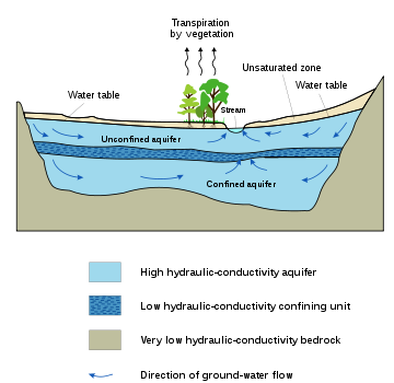
to the west; later strata comprise the Alamosa formation, alternating layers of sand, gravel, and clay. The relatively impermeable clay layers trap ground water in the "confined aquifer
Aquifer
An aquifer is a wet underground layer of water-bearing permeable rock or unconsolidated materials from which groundwater can be usefully extracted using a water well. The study of water flow in aquifers and the characterization of aquifers is called hydrogeology...
" which, if tapped, supplies artesian wells. Surface waters, including the Rio Grande and other streams, are hydrologically connected to the "unconfined aquifer" a shallow ground water formation which underlies much of the valley. The deeper confined aquifer also has sufficient hydrological connection with the surface waters of the valley that they are not considered for the purposes of Colorado water law "nontributary" waters which could legally be mined. Streams which flow into the valley, particularly the Rio Grande, have deposited alluvial fan
Alluvial fan
An alluvial fan is a fan-shaped deposit formed where a fast flowing stream flattens, slows, and spreads typically at the exit of a canyon onto a flatter plain. A convergence of neighboring alluvial fans into a single apron of deposits against a slope is called a bajada, or compound alluvial...
s where they emerge from higher terrain onto the valley floor.
The Ancestral Rockies, the Central Colorado Trough, and the San Luis-Uncompahgre Highlands
The gap between PrecambrianPrecambrian
The Precambrian is the name which describes the large span of time in Earth's history before the current Phanerozoic Eon, and is a Supereon divided into several eons of the geologic time scale...
basement rock and Eocene
Eocene
The Eocene Epoch, lasting from about 56 to 34 million years ago , is a major division of the geologic timescale and the second epoch of the Paleogene Period in the Cenozoic Era. The Eocene spans the time from the end of the Palaeocene Epoch to the beginning of the Oligocene Epoch. The start of the...
alluvial deposits is considered evidence that southern Colorado, including the San Luis Valley, were highlands during that period. There were lowlands to the north in central Colorado, the Colorado sag
Sag (geology)
In geology a sag, or trough, is a depressed, persistent, low area; the opposite of an arch, or ridge, a raised, persistent, high area. The terms sag and arch were used historically to describe very large features, for example, characterizing North America as two arches with a sag between them.Also,...
, an east-west basin. It is from those highlands, in Paleozoic
Paleozoic
The Paleozoic era is the earliest of three geologic eras of the Phanerozoic eon, spanning from roughly...
, Pennsylvanian
Pennsylvanian
The Pennsylvanian is, in the ICS geologic timescale, the younger of two subperiods of the Carboniferous Period. It lasted from roughly . As with most other geochronologic units, the rock beds that define the Pennsylvanian are well identified, but the exact date of the start and end are uncertain...
, and Permian
Permian
The PermianThe term "Permian" was introduced into geology in 1841 by Sir Sir R. I. Murchison, president of the Geological Society of London, who identified typical strata in extensive Russian explorations undertaken with Edouard de Verneuil; Murchison asserted in 1841 that he named his "Permian...
times that the coarse alluvial deposits of the Sangre de Cristo Formation such as the Crestone Conglomerate originated. The Minturn Formation, a limestone formation exemplified at Marble Mountain on the crest of the Sangre de Cristos, is evidence of a sea in the Central Colorado Trough during the era of the Ancestral Rockies.
Western Interior Seaway
In the middle and late CretaceousCretaceous
The Cretaceous , derived from the Latin "creta" , usually abbreviated K for its German translation Kreide , is a geologic period and system from circa to million years ago. In the geologic timescale, the Cretaceous follows the Jurassic period and is followed by the Paleogene period of the...
Period, about 100 million years ago, the San Luis Valley lay on the shore of or beneath the Western Interior Seaway
Western Interior Seaway
The Western Interior Seaway, also called the Cretaceous Seaway, the Niobraran Sea, and the North American Inland Sea, was a huge inland sea that split the continent of North America into two halves, Laramidia and Appalachia, during most of the mid- and late-Cretaceous Period...
a shallow sea which divided North America into two parts. As the sea deepened and expanded sand and gravel eroded from mountains in the west was deposited in the Dakota Formation
Dakota Formation
The Dakota Formation is a geologic formation composed of sedimentary rocks deposited on the western side of the Late Cretaceous Western Interior Seaway. F.B. Meek and F.V. Hayden named it for exposures along the Missouri River near Dakota City, Nebraska...
; later, when the sea was deeper mud and sand were deposited in the Mancos Shale
Mancos Shale
The Mancos Shale or Mancos Group is an Upper Cretaceous geologic formation of the Western United States dominated by mudrock that accumulated in offshore and marine environments of the Cretaceous North American Inland Sea. The Mancos was deposited during the Cenomanian through Campanian ages,...
. The Lexam oil play
Petroleum play
In geology, a petroleum play, or simply a play, is a group of petroleum fields or prospects in the same region that are controlled by the same set of geological circumstances.The normal steps in the play cycle are:...
near Crestone is based on the hypothesis that there is oil trapped in Dakota Formation sandstones lying beneath Mancos Shale to the west of the Sangre de Criso fault at the western base of the Sangre de Cristo Range southwest of Crestone. Drilling at the base of the range during gold exploration in the vicinity showed small amounts of oil and evidence of the existence of those formations as well as the underlying Morrison Formation
Morrison Formation
The Morrison Formation is a distinctive sequence of Late Jurassic sedimentary rock that is found in the western United States, which has been the most fertile source of dinosaur fossils in North America. It is composed of mudstone, sandstone, siltstone and limestone and is light grey, greenish...
. Prior to this discovery it was assumed that these formations had eroded away during the Laramide orogeny
Laramide orogeny
The Laramide orogeny was a period of mountain building in western North America, which started in the Late Cretaceous, 70 to 80 million years ago, and ended 35 to 55 million years ago. The exact duration and ages of beginning and end of the orogeny are in dispute, as is the cause. The Laramide...
.
Laramide orogeny
Building of the Rocky MountainsRocky Mountains
The Rocky Mountains are a major mountain range in western North America. The Rocky Mountains stretch more than from the northernmost part of British Columbia, in western Canada, to New Mexico, in the southwestern United States...
by folding during the Laramide orogeny
Laramide orogeny
The Laramide orogeny was a period of mountain building in western North America, which started in the Late Cretaceous, 70 to 80 million years ago, and ended 35 to 55 million years ago. The exact duration and ages of beginning and end of the orogeny are in dispute, as is the cause. The Laramide...
80 to 55 million years ago created a highland, the San Luis-Brazos uplift, in the area of the San Luis Valley. This process over 30 million years resulted in an elevated and highly eroded peneplain
Peneplain
A peneplain is a low-relief plain representing the final stage of fluvial erosion during times of extended tectonic stability. The existence of peneplains, and peneplanation as a geomorphological process, is not without controversy, due to a lack of contemporary examples and uncertainty in...
where the San Luis Valley is today. There was a basin in its western portion which may have drained west through the course historically followed
Sag (geology)
In geology a sag, or trough, is a depressed, persistent, low area; the opposite of an arch, or ridge, a raised, persistent, high area. The terms sag and arch were used historically to describe very large features, for example, characterizing North America as two arches with a sag between them.Also,...
by the San Juan River. Sedimentary deposits formed in that basin during Eocene
Eocene
The Eocene Epoch, lasting from about 56 to 34 million years ago , is a major division of the geologic timescale and the second epoch of the Paleogene Period in the Cenozoic Era. The Eocene spans the time from the end of the Palaeocene Epoch to the beginning of the Oligocene Epoch. The start of the...
times remain in place beneath the western portion of the San Luis Valley.
External links and further reading
Utes
Prior to 1868 the Capote (Kapota) band of UteUte Tribe
The Ute are an American Indian people now living primarily in Utah and Colorado. There are three Ute tribal reservations: Uintah-Ouray in northeastern Utah ; Southern Ute in Colorado ; and Ute Mountain which primarily lies in Colorado, but extends to Utah and New Mexico . The name of the state of...
Indians lived in the valley. The Utes made a treaty of peace with the United States in 1849 shortly after the Mexican War. Shortly thereafter settlers from New Mexico established several small settlements in what is now Colorado and in 1868 the Utes were removed to a reservation in western Colorado. They continued to play a role in Saguache in the northwestern corner of the valley from the Los Pinos Agency to the west of Saguache until they lost their expansive reservation as the result of the Meeker massacre in 1879.
Spanish and Mexican administration
The area was administered as part of the Spanish, later Mexican, province of Nuevo MexicoNuevo México
-In Mexico:*Nuevo México, Chiapas*Nuevo México, Jalisco*Santa Fe de Nuevo México ; the province or kingdom of which Santa Fe was the capital....
until the area was ceded to the United States in 1848 after the Mexican-American war in the Treaty of Guadalupe Hidalgo
Treaty of Guadalupe Hidalgo
The Treaty of Guadalupe Hidalgo is the peace treaty, largely dictated by the United States to the interim government of a militarily occupied Mexico City, that ended the Mexican-American War on February 2, 1848...
.
United States administration
Extensive settlement began in the Valley, again primarily by Hispanic farmers and ranchers from New Mexico in the 1850s after the construction of Fort Massachusetts by the U.S. Army for protection against the Utes, who previously barred settlers. The history of the post-war U.S. military presence in the Valley is preserved at Fort GarlandFort Garland
Fort Garland , Colorado, USA, was designed to house two companies of soldiers to protect settlers in the San Luis Valley, which was the Territory of New Mexico...
and other sites in the Valley, which became part of the Territory of Colorado in 1861. The lands in the valley were surveyed by the United States using the New Mexico Meridian and Baseline
New Mexico Meridian
The New Mexico Meridian, is longitude 106° 53' 40" west from Greenwich. It extends throughout New Mexico and into Colorado, and together with the baseline, at latitude 34° 15' 25" north, governs township and range surveys in New Mexico, except those in the northwest corner of the state which refer...
, unlike the rest of Colorado. The valley was one of eight candidate sites to detonate the first atomic bomb when White Sands Proving Ground was selected for the Trinity (nuclear test). Today, the Valley has the largest native Hispanic population in Colorado; many families are directly descended from the original New Mexican settlers. The original Ute population was confined to the Southern Ute
Southern Ute Indian Reservation
The Southern Ute Indian Reservation lies in southwestern Colorado, USA, along the northern border of New Mexico. Its territory consists of land from three counties; in descending order of surface area they are La Plata, Archuleta, and Montezuma Counties. The reservation has a land area of 1,058.785...
and Ute Mountain
Ute Mountain Ute Tribe
The Ute Mountain Ute Tribe is one of three federally recognized tribes of the Ute Nation, and are mostly descendants of the historic Weeminuche Band who moved to the Southern Ute reservation in 1897...
Indian reservations in the late 19th century.
Land ownership and management
About 50% of the 2000000 acres (809,372 ha) in the San Luis Valley is privately owned. Much of the land in the south part of the Valley, in Conejos and Costilla counties, was originally part of large Mexican land grants and is private land.500000 acres (202,343 ha) on the borders of the valley (generally adjacent to National Forest Lands) are managed by the Bureau of Land Management
Bureau of Land Management
The Bureau of Land Management is an agency within the United States Department of the Interior which administers America's public lands, totaling approximately , or one-eighth of the landmass of the country. The BLM also manages of subsurface mineral estate underlying federal, state and private...
, BLM, a division of the United States Department of the Interior
United States Department of the Interior
The United States Department of the Interior is the United States federal executive department of the U.S. government responsible for the management and conservation of most federal land and natural resources, and the administration of programs relating to Native Americans, Alaska Natives, Native...
. This land is usually leased to neighboring ranches for grazing for a nominal fee. Part of the value of a ranch is its continuing lease of BLM or National Forest lands.
Public lands in the mountains surrounding the San Luis Valley are generally part of the Rio Grande National Forest
United States National Forest
National Forest is a classification of federal lands in the United States.National Forests are largely forest and woodland areas owned by the federal government and managed by the United States Forest Service, part of the United States Department of Agriculture. Land management of these areas...
and are managed by the United States Forest Service
United States Forest Service
The United States Forest Service is an agency of the United States Department of Agriculture that administers the nation's 155 national forests and 20 national grasslands, which encompass...
.
Large areas of private lands have either been subdivided into subdivisions of small "ranch" lots or have been sold or donated to the Federal government and make up portions of the Great Sand Dunes National Park and Preserve
Great Sand Dunes National Park and Preserve
-Other features:The park also contains alpine lakes and tundra, six peaks over 13,000 feet in elevation, ancient spruce and pine forests, large stands of aspen and cottonwood, grasslands, and wetlands — all habitat for diverse wildlife and plant species.One of the most unusual features of...
, other wildlife preserves, and various state wildlife sites.
Agriculture and wildlife
Agriculture in the San Luis Valley is generally concentrated around the Colorado towns of Alamosa, Monte Vista and Center. Principal crops include potatoPotato
The potato is a starchy, tuberous crop from the perennial Solanum tuberosum of the Solanaceae family . The word potato may refer to the plant itself as well as the edible tuber. In the region of the Andes, there are some other closely related cultivated potato species...
es, head lettuce
Lettuce
Lettuce is a temperate annual or biennial plant of the daisy family Asteraceae. It is most often grown as a leaf vegetable. It is eaten either raw, notably in salads, sandwiches, hamburgers, tacos, and many other dishes, or cooked, as in Chinese cuisine in which the stem becomes just as important...
and barley
Barley
Barley is a major cereal grain, a member of the grass family. It serves as a major animal fodder, as a base malt for beer and certain distilled beverages, and as a component of various health foods...
. The barley grown here is the main supplier for Coors beer company. In 1982, quinoa
Quinoa
Quinoa , a species of goosefoot , is a grain-like crop grown primarily for its edible seeds. It is a pseudocereal rather than a true cereal, or grain, as it is not a member of the grass family...
was successfully grown for the first time outside of South America in the San Luis Valley of Colorado, and commercial growth has occurred since 1987. Less favored areas with a shorter growing season and less access to water rights tend to be devoted to alfalfa
Alfalfa
Alfalfa is a flowering plant in the pea family Fabaceae cultivated as an important forage crop in the US, Canada, Argentina, France, Australia, the Middle East, South Africa, and many other countries. It is known as lucerne in the UK, France, Australia, South Africa and New Zealand, and known as...
and grazing
Grazing
Grazing generally describes a type of feeding, in which a herbivore feeds on plants , and also on other multicellular autotrophs...
. Broad areas, especially in Saguache County, Colorado
Saguache County, Colorado
Saguache County is the seventh most extensive of the 64 counties of the state of Colorado of the United States. The county name comes from a Ute language word meaning “blue earth” or “water at blue earth”. The county population was 5,917 at U.S. Census 2000...
have a high water table
Water table
The water table is the level at which the submarine pressure is far from atmospheric pressure. It may be conveniently visualized as the 'surface' of the subsurface materials that are saturated with groundwater in a given vicinity. However, saturated conditions may extend above the water table as...
or are even flooded part of the year. Uncultivated land is often covered with "chico", low brush such as rabbitbrush
Chrysothamnus
Chrysothamnus is a member of the plant family Asteraceae. It is a semi-deciduous shrub, sometimes also called sagebrush. The native distribution is in the arid western United States and northern Mexico...
, greasewood
Greasewood
Greasewood, Sarcobatus, is a genus of one or two species of flowering plants. Traditionally it has been treated in the family Chenopodiaceae, but the APG II system, of 2003, places it in the family Sarcobataceae....
and other woody species. Cropland is typically irrigated with large (1/4-mile radius) center-pivot irrigation systems, and a common feature of the Rio Grande Delta area where the Rio Grande enters the valley are large piles of potato-sized rocks screened from the soil.
The area supports a wide variety of wildlife. Sandhill crane
Sandhill Crane
The Sandhill Crane is a large crane of North America and extreme northeastern Siberia. The common name of this bird references habitat like that at the Platte River, on the edge of Nebraska's Sandhills in the American Midwest...
s migrate through the valley every spring and fall. The Monte Vista Crane Festival takes place in March, centering on the wildlife refuge
Wildlife refuge
A wildlife refuge, also called a wildlife sanctuary, may be a naturally occurring sanctuary, such as an island, that provides protection for species from hunting, predation or competition, or it may refer to a protected area, a geographic territory within which wildlife is protected...
located six miles (10 km) south of town. Occasionally, a whooping crane
Whooping Crane
The whooping crane , the tallest North American bird, is an endangered crane species named for its whooping sound. Along with the Sandhill Crane, it is one of only two crane species found in North America. The whooping crane's lifespan is estimated to be 22 to 24 years in the wild...
can be spotted among the thousands of grey sandhills. The valley is a flyway for many migrating birds including avocets, bald eagle
Bald Eagle
The Bald Eagle is a bird of prey found in North America. It is the national bird and symbol of the United States of America. This sea eagle has two known sub-species and forms a species pair with the White-tailed Eagle...
s, goldfinch
Goldfinch
Goldfinch may refer to any of the following species of bird from the genus Carduelis:* American Goldfinch, Carduelis tristis* European Goldfinch, Carduelis carduelis* Lawrence's Goldfinch, Carduelis lawrencei...
es, and a plethora of hawk
Hawk
The term hawk can be used in several ways:* In strict usage in Australia and Africa, to mean any of the species in the subfamily Accipitrinae, which comprises the genera Accipiter, Micronisus, Melierax, Urotriorchis and Megatriorchis. The large and widespread Accipiter genus includes goshawks,...
varieties.
Artistic community
There are over 500 known artists living in the San Luis Valley as evidenced by an onging directory maintained by Monte Vista artists' group, The Art Thing, The Art Thing's membership boasts several nationally recognized artists working in various media. Monte Vista is also home to the Monte Arts Council as well as several festivals and an art tour that attracts artists from as far away as California and North Carolina.The San Luis Valley is home to four active live theaters, two at Adams State College, The Creede Repertory Theater and Rocky Mountain Stage in Monte Vista. In August there are two major Music Festivals, the Crestone Music Festival and Spanish Trails Music Festival and Mexican Rodeo. Music in the valley has two well known sponsors in the South Fork Music Association and the Alamosa Live Music Association.
San Luis Valley is also known as the "Mysterious Valley" (see book by Christopher O'Brien). Over the years there have been numerous unexplained UFO sightings in the San Luis Valley of Colorado. See also UFO Watchtower
UFO Watchtower
The UFO Watchtower is an observation platform, campground, and gift shop north of Hooper, Colorado. The watchtower, which has a 360-degree view of the San Luis Valley, was created by Judy Messoline in May 2000 to capitalize on the existing use of the property by UFO observers.There have been TV...
Demography
A significant portion of the residents of the San Luis Valley are Hispanic with historic populations in Costilla and Conejos counties which were settled by early migrants from New Mexico. There are small AmishAmish
The Amish , sometimes referred to as Amish Mennonites, are a group of Christian church fellowships that form a subgroup of the Mennonite churches...
communities which were recently established.
Economy
Predominantly agricultural in nature, the area is also one of the poorest rural areas of Colorado. Tourism has become a more important part of the economy in recent years, coupled with attempts to establish the area as a retirement community. Adams State CollegeAdams State College
Adams State College is a small state-supported liberal arts college in Alamosa, Colorado, U.S., in the San Luis Valley.-History:Adams State was founded in 1921 as a teacher's college but now offers a variety of programs including masters degrees in many fields...
, a four-year state college at Alamosa, with approximately 2,500 resident students, is the major educational institution in the Valley. It is supplemented by a campus of Trinidad State Junior College
Trinidad State Junior College
Founded in 1925, Trinidad State Junior College is a two year college located in Trinidad, Colorado, United States, with a secondary satellite campus located in Alamosa, Colorado...
in Alamosa. San Luis Valley Regional Medical Center
San Luis Valley Regional Medical Center
San Luis Valley Regional Medical Center is an acute care hospital located in the San Luis Valley in Alamosa, Colorado. It serves residents and visitors in southern Colorado and northern New Mexico....
, a full service Acute-Care hospital and specialty physician clinic is the largest employer in the Valley with over 600 employees. The arts are becoming an increasing force in developing the economy of the San Luis Valley.
Solar energy
The San Luis Valley is an alpine desert environment which is conducive to solar energy production. It has the highest per capita concentration of home-based solar energy systems in the United States. There are a number of proposed industrial-scale solar-electric generating facilities which have been built or are under consideration. Colorado law requires that 30% of the power used in the state be generated from renewable sources by 2020. It also requires that 3% of the power generated be used at or near where it is generated, distributed generationDistributed generation
Distributed generation, also called on-site generation, dispersed generation, embedded generation, decentralized generation, decentralized energy or distributed energy, generates electricity from many small energy sources....
. There is an active market in selling or leasing land to be used for solar facilities. In 2007 when SunEdison
SunEdison
Sun Edison LLC owns and operates power plants in North America and provides solar-generated energy to commercial, government, and utility customers. The company provides solar energy services, which include renewable power, monitoring, marketing, renewable portfolio standards, and solar tariff...
, a 8.2 megawatt solar photovoltaic plant near the town of Mosca, Colorado
Mosca, Colorado
Mosca is an unincorporated town and a U.S. Post Office in Alamosa County, Colorado, United States. It was named for the nearby Mosca Pass, which was named for the Spanish explorer, Luis de Moscoso de Alvarado...
, was built it was the largest solar electric facility in the United States. On December 11, 2009, more than 125 people gathered to respond by a proposal by Tessera Solar (affiliated with Stirling Energy Systems
Stirling Energy Systems
Stirling Energy Systems is a Scottsdale, Arizona-based company which develops equipment for utility-scale renewable energy power plants and distributed electrical generating systems....
to install 8,000 40-foot parabolic mirrors on 1500 acres (6.1 km²) near Saguache, Colorado
Saguache, Colorado
The historic town of Saguache is a Statutory Town that is the county seat and most populous town of Saguache County, Colorado, United States. The population was 578 at the U.S. Census 2000.-Name:...
. At issue was the noise expected to be generated by the numerous stirling engine
Stirling engine
A Stirling engine is a heat engine operating by cyclic compression and expansion of air or other gas, the working fluid, at different temperature levels such that there is a net conversion of heat energy to mechanical work....
s to be used to position the collectors and the wisdom of industrial solar facilities. The application for a permit was withdrawn on July 11, 2011. There has also been controversy regarding proposed transmission lines over both Poncha and La Veta passes, which would open the door to much more industrial solar development. Opposition to a proposed transmission line has resulted in possible delay in development of solar facilities by Xcel Energy
Xcel Energy
Xcel Energy, Inc. is a public utility company based in Minneapolis, Minnesota, serving customers in Colorado, Michigan, Minnesota, New Mexico, North Dakota, South Dakota, Texas, and Wisconsin. Primary services are electricity and natural gas...
which together with Tri-State Generation and Transmission Association serves the valley.
External links
- sanluisvalley.us San Luis Valley Information Center
- Documents generated by the Tessera industrial solar energy application in Saguache County Land use office, Saguache County