
San Jacinto Peak
Encyclopedia
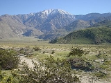
San Jacinto Peak, 10,834 feet (3,302 m), is the highest peak of the San Jacinto Mountains
, and of Riverside County, California
. It lies within Mount San Jacinto State Park
. Naturalist John Muir
wrote of San Jacinto Peak, "The view from San Jacinto is the most sublime spectacle to be found anywhere on this earth!"
San Jacinto Peak is one of the most topographically prominent
peaks in the United States
. It is ranked 6th among peaks in the 48 contiguous states
.
; to the west, it borders the mountain community of Idyllwild
. The peak is also frequently called Mount San Jacinto. The steep escarpment
of its north face, above Snow Creek, climbs over 10000 feet (3,048 m) in 7 miles (11.3 km). This is one of the largest gains in elevation over such a small horizontal distance in the contiguous United States
.
From the peak, San Gorgonio Mountain
can be seen across the San Gorgonio Pass
. Also easily visible below is the Coachella Valley
and the Salton Sea
. In addition, much of the Inland Empire
, including Ontario
to the west, can be viewed on a clear day.
Mount San Jacinto is one of the "Three Saints," a name occasionally used to describe the high points of the three tallest mountain ranges in Southern California: San Jacinto Peak, Mount San Gorgonio (high point of the San Bernardino Mountains
), and Mount San Antonio
(high point of the San Gabriel Mountains
).
Indians, the peak was known as I a kitch (or Aya Kaich), meaning "smooth cliffs." It was the home of Dakush, the meteor and legendary founder of the Cahuilla.
In 1878, a Wheeler Survey
topographical party led by rancher Charles Thomas of Garner Valley climbed the peak. The Wheeler Survey gave the mountain the name "San Jacinto Peak" (rather than "Mt. San Jacinto" or "San Jacinto Mountain.")
The earliest recorded ascent of the peak was made in September, 1874 by "F. of Riverside," according to a description of his ascent in the San Diego Union
. The first successful ascent of the difficult northeast escarpment was made in 1931 by Floyd Vernoy and Stewart White of Riverside
.
The peak is flanked by Jean Peak 10670 feet (3,252.2 m) and Marion Mountain (10,362 feet, 3158 meters). These peaks were named in 1897 by USGS
topographer Edmund Taylor Perkins, Jr. Perkins named Jean Peak for his sweetheart and future bride, Jean Waters of Plumas County, whom he married in 1903. He named Marion Mountain after Marion Kelly, his girlfriend, a teacher for the Indian Bureau
at the Morongo Valley Reservation
. According to a local legend, Perkins spent the summer of 1897 deciding which woman to marry while he conducted his topographical
survey of San Jacinto Peak and its environs.
Nearby Cornell Peak is named for Cornell University
, the alma mater of geologist Robert T. Hill
. Perkins and Hill were camping in Round Valley when Hill remarked that the peak looked like the campanile tower at Cornell. Perkins later named the peak Cornell Peak.
In 1931 and 1932, the San Jacinto Mountain Chamber of Commerce sponsored a Labor Day footrace from Idyllwild to San Jacinto Peak and back, a distance of 18 miles and 5,300 feet. The 1931 race was won by Tom Humphreys, a Hopi
, in 3:36:30. Humphreys won the race again in 1932 with a time of 3:12. Near the summit of San Jacinto peak is a stone hut that was built in 1935 by the Civilian Conservation Corps
.
from Valley Station at 2643 feet (805.6 m) near Palm Springs up to Mountain Station at 8516 feet (2,595.7 m). From there, one can easily climb the mountain face via trails.
Another route is to hike the Marion Mountain Trail from near the mountain town of Idyllwild.
The Cactus to Clouds trail involves an arduous climb of over 10000 feet (3,048 m) from the Palm Springs Art Museum to the summit at 10800 feet (3,291.8 m).
The mountain is quite rugged in places, with several outdoor hazards
that hikers may be unprepared for, including high altitude, severe weather, steep rock faces, and wild animals. Hikers and climbers die or are harmed every year.
Mountaineers can tackle the mountain's steep north face from the town of Snow Creek. This route is a challenging mountaineering route that gains nearly 10,000 feet in less than 7 miles and involves hiking over rough terrain, climbing or scrambling on steep rock and long, sustained snow climbing with crampons and an ice axe. Climbers have been seriously injured or died while attempting this challenging route to the summit.
San Jacinto Mountains
The San Jacinto Mountains are a mountain range east of Los Angeles in southern California in the United States. The mountains are named for Saint Hyacinth . The Pacific Crest Trail runs along the spine of the range.The range extends for approximately from the San Bernardino Mountains southeast to...
, and of Riverside County, California
Riverside County, California
Riverside County is a county in the U.S. state of California. One of 58 California counties, it covers in the southern part of the state, and stretches from Orange County to the Colorado River, which forms the state border with Arizona. The county derives its name from the city of Riverside,...
. It lies within Mount San Jacinto State Park
Mount San Jacinto State Park
Mount San Jacinto State Park is in the San Jacinto Mountains, of the Peninsular Ranges system, in Riverside County, California. The park is near the Greater Los Angeles and the San Diego metropolitan area.-Geography:...
. Naturalist John Muir
John Muir
John Muir was a Scottish-born American naturalist, author, and early advocate of preservation of wilderness in the United States. His letters, essays, and books telling of his adventures in nature, especially in the Sierra Nevada mountains of California, have been read by millions...
wrote of San Jacinto Peak, "The view from San Jacinto is the most sublime spectacle to be found anywhere on this earth!"
San Jacinto Peak is one of the most topographically prominent
Topographic prominence
In topography, prominence, also known as autonomous height, relative height, shoulder drop , or prime factor , categorizes the height of the mountain's or hill's summit by the elevation between it and the lowest contour line encircling it and no higher summit...
peaks in the United States
United States
The United States of America is a federal constitutional republic comprising fifty states and a federal district...
. It is ranked 6th among peaks in the 48 contiguous states
Contiguous United States
The contiguous United States are the 48 U.S. states on the continent of North America that are south of Canada and north of Mexico, plus the District of Columbia....
.
Geography
To the east, the peak towers over the city of Palm SpringsPalm Springs, California
Palm Springs is a desert city in Riverside County, California, within the Coachella Valley. It is located approximately 37 miles east of San Bernardino, 111 miles east of Los Angeles and 136 miles northeast of San Diego...
; to the west, it borders the mountain community of Idyllwild
Idyllwild-Pine Cove, California
Idyllwild, Pine Cove, and Fern Valley are three adjacent communities, of which Idyllwild is the largest, located in the San Jacinto Mountains in Riverside County, California, United States. "Mile-high Idyllwild" is a popular southern California mountain resort about one mile in altitude...
. The peak is also frequently called Mount San Jacinto. The steep escarpment
Escarpment
An escarpment is a steep slope or long cliff that occurs from erosion or faulting and separates two relatively level areas of differing elevations.-Description and variants:...
of its north face, above Snow Creek, climbs over 10000 feet (3,048 m) in 7 miles (11.3 km). This is one of the largest gains in elevation over such a small horizontal distance in the contiguous United States
Contiguous United States
The contiguous United States are the 48 U.S. states on the continent of North America that are south of Canada and north of Mexico, plus the District of Columbia....
.
From the peak, San Gorgonio Mountain
San Gorgonio Mountain
San Gorgonio Mountain, also known locally as Mount San Gorgonio, or Old Greyback, is the highest peak in Southern California at . It is in the San Bernardino Mountains, east of the city of San Bernardino and north-northeast of San Gorgonio Pass. It lies within the San Gorgonio Wilderness, part of...
can be seen across the San Gorgonio Pass
San Gorgonio Pass
The San Gorgonio Pass el. cuts between the San Bernardino Mountains on the north and the San Jacinto Mountains to the south. Like the Cajon Pass to the northwest, it was also created by the San Andreas Fault...
. Also easily visible below is the Coachella Valley
Coachella Valley
Coachella Valley is a large valley landform in Southern California. The valley extends for approximately 45 miles in Riverside County southeast from the San Bernardino Mountains to the saltwater Salton Sea, the largest lake in California...
and the Salton Sea
Salton Sea
The Salton Sea is a shallow, saline, endorheic rift lake located directly on the San Andreas Fault, predominantly in California's Imperial Valley. The lake occupies the lowest elevations of the Salton Sink in the Colorado Desert of Imperial and Riverside counties in Southern California. Like Death...
. In addition, much of the Inland Empire
Inland Empire (California)
The Inland Empire is a region in Southern California. The region sits directly east of the Los Angeles metropolitan area. The Inland Empire most commonly is used in reference to the U.S. Census Bureau's federally-defined Riverside-San Bernardino-Ontario metropolitan area, which covers more than...
, including Ontario
Ontario, California
Ontario is a city located in San Bernardino County, California, United States, 35 miles east of downtown Los Angeles. Located in the western part of the Inland Empire region, it lies just east of the Los Angeles county line and is part of the Greater Los Angeles Area...
to the west, can be viewed on a clear day.
Mount San Jacinto is one of the "Three Saints," a name occasionally used to describe the high points of the three tallest mountain ranges in Southern California: San Jacinto Peak, Mount San Gorgonio (high point of the San Bernardino Mountains
San Bernardino Mountains
The San Bernardino Mountains are a short transverse mountain range north and east of San Bernardino in Southern California in the United States. The mountains run for approximately 60 miles east-west on the southern edge of the Mojave Desert in southwestern San Bernardino County, north of the...
), and Mount San Antonio
Mount San Antonio
Mount San Antonio, commonly known as Old Baldy or Mt Baldy, at , is the highest peak in the San Gabriel Mountains, and the highest point in Los Angeles County...
(high point of the San Gabriel Mountains
San Gabriel Mountains
The San Gabriel Mountains Range is located in northern Los Angeles County and western San Bernardino County, California, United States. The mountain range lies between the Los Angeles Basin and the Mojave Desert, with Interstate 5 to the west and Interstate 15 to the east...
).
History
To the CahuillaCahuilla
The Cahuilla, Iviatim in their own language, are Indians with a common culture whose ancestors inhabited inland areas of southern California 2,000 years ago. Their original territory included an area of about . The traditional Cahuilla territory was near the geographic center of Southern California...
Indians, the peak was known as I a kitch (or Aya Kaich), meaning "smooth cliffs." It was the home of Dakush, the meteor and legendary founder of the Cahuilla.
In 1878, a Wheeler Survey
Wheeler Survey
The Wheeler Survey was a survey of a portion of the United States lying west of the 100th meridian. It comprised multiple expeditions, and was supervised by First Lieutenant George Montague Wheeler....
topographical party led by rancher Charles Thomas of Garner Valley climbed the peak. The Wheeler Survey gave the mountain the name "San Jacinto Peak" (rather than "Mt. San Jacinto" or "San Jacinto Mountain.")
The earliest recorded ascent of the peak was made in September, 1874 by "F. of Riverside," according to a description of his ascent in the San Diego Union
The San Diego Union-Tribune
-Predecessors:The predecessor newspapers of the Union-Tribune were:* San Diego Sun, founded 1861 and merged with the Evening Tribune in 1939.* San Diego Union, founded October 10, 1868.* Evening Tribune, founded December 2, 1895.-Ownership:...
. The first successful ascent of the difficult northeast escarpment was made in 1931 by Floyd Vernoy and Stewart White of Riverside
Riverside, California
Riverside is a city in Riverside County, California, United States, and the county seat of the eponymous county. Named for its location beside the Santa Ana River, it is the largest city in the Riverside-San Bernardino-Ontario metropolitan area of Southern California, 4th largest inland California...
.
The peak is flanked by Jean Peak 10670 feet (3,252.2 m) and Marion Mountain (10,362 feet, 3158 meters). These peaks were named in 1897 by USGS
United States Geological Survey
The United States Geological Survey is a scientific agency of the United States government. The scientists of the USGS study the landscape of the United States, its natural resources, and the natural hazards that threaten it. The organization has four major science disciplines, concerning biology,...
topographer Edmund Taylor Perkins, Jr. Perkins named Jean Peak for his sweetheart and future bride, Jean Waters of Plumas County, whom he married in 1903. He named Marion Mountain after Marion Kelly, his girlfriend, a teacher for the Indian Bureau
Bureau of Indian Affairs
The Bureau of Indian Affairs is an agency of the federal government of the United States within the US Department of the Interior. It is responsible for the administration and management of of land held in trust by the United States for Native Americans in the United States, Native American...
at the Morongo Valley Reservation
Morongo Valley, California
Morongo Valley is a census-designated place in San Bernardino County, California, United States. The population was 3,552 at the 2010 census, up from 1,929 at the 2000 census.-Geography and climate:...
. According to a local legend, Perkins spent the summer of 1897 deciding which woman to marry while he conducted his topographical
Topography
Topography is the study of Earth's surface shape and features or those ofplanets, moons, and asteroids...
survey of San Jacinto Peak and its environs.
Nearby Cornell Peak is named for Cornell University
Cornell University
Cornell University is an Ivy League university located in Ithaca, New York, United States. It is a private land-grant university, receiving annual funding from the State of New York for certain educational missions...
, the alma mater of geologist Robert T. Hill
Robert T. Hill
Robert Thomas Hill was a significant figure in the development of American geology during the late nineteenth century and in the early part of the twentieth century...
. Perkins and Hill were camping in Round Valley when Hill remarked that the peak looked like the campanile tower at Cornell. Perkins later named the peak Cornell Peak.
In 1931 and 1932, the San Jacinto Mountain Chamber of Commerce sponsored a Labor Day footrace from Idyllwild to San Jacinto Peak and back, a distance of 18 miles and 5,300 feet. The 1931 race was won by Tom Humphreys, a Hopi
Hopi
The Hopi are a federally recognized tribe of indigenous Native American people, who primarily live on the Hopi Reservation in northeastern Arizona. The Hopi area according to the 2000 census has a population of 6,946 people. Their Hopi language is one of the 30 of the Uto-Aztecan language...
, in 3:36:30. Humphreys won the race again in 1932 with a time of 3:12. Near the summit of San Jacinto peak is a stone hut that was built in 1935 by the Civilian Conservation Corps
Civilian Conservation Corps
The Civilian Conservation Corps was a public work relief program that operated from 1933 to 1942 in the United States for unemployed, unmarried men from relief families, ages 18–25. A part of the New Deal of President Franklin D...
.
Hiking
San Jacinto Peak is easily accessible, as many trails penetrate the San Jacinto Wilderness. The most popular route starts with a ride on the Palm Springs Aerial TramwayPalm Springs Aerial Tramway
The Palm Springs Aerial Tramway in Palm Springs, California is the largest rotating aerial tramway in the world. It was opened in September 1963 as a way of getting from the floor of the Coachella Valley to near the top of San Jacinto Peak and was constructed in rugged Chino Canyon...
from Valley Station at 2643 feet (805.6 m) near Palm Springs up to Mountain Station at 8516 feet (2,595.7 m). From there, one can easily climb the mountain face via trails.
Another route is to hike the Marion Mountain Trail from near the mountain town of Idyllwild.
The Cactus to Clouds trail involves an arduous climb of over 10000 feet (3,048 m) from the Palm Springs Art Museum to the summit at 10800 feet (3,291.8 m).
The mountain is quite rugged in places, with several outdoor hazards
Hazards of outdoor activities
Any outdoor activity entails many risks, even if participants do not recklessly place themselves in harm's way. Even a simple accident may create a dangerous situation that requires survival skills. However, with the correct precautions, outdoor recreation can be enjoyable and safe.- General...
that hikers may be unprepared for, including high altitude, severe weather, steep rock faces, and wild animals. Hikers and climbers die or are harmed every year.
Mountaineers can tackle the mountain's steep north face from the town of Snow Creek. This route is a challenging mountaineering route that gains nearly 10,000 feet in less than 7 miles and involves hiking over rough terrain, climbing or scrambling on steep rock and long, sustained snow climbing with crampons and an ice axe. Climbers have been seriously injured or died while attempting this challenging route to the summit.
See also
- List of highest points in California by county
- Mountain peaks of CaliforniaMountain peaks of CaliforniaThis article comprises three sortable tables of major mountain peaks of the U.S. State of California.Topographic elevation is the vertical distance above the reference geoid, a precise mathematical model of the Earth's sea level as an equipotential gravitational surface...
- Mountain peaks of North AmericaMountain peaks of North AmericaThis article comprises three sortable tables of major mountain peaks of greater North America.This article defines greater North America as the portion of the continental landmass of the Americas extending northward from Panama plus the islands surrounding that landmass...
- Mountain peaks of the United StatesMountain peaks of the United StatesThis article comprises three sortable tables of the major mountain peaks of the United States of America.Topographic elevation is the vertical distance above the reference geoid, a precise mathematical model of the Earth's sea level as an equipotential gravitational surface...