
SE postcode area
Encyclopedia
The SE postcode area, also known as the London SE postcode area, is the part of the London
post town covering part of south east London
, England. It loosely corresponds to the London Borough of Southwark
, London Borough of Lewisham
and London Borough of Greenwich
, with eastern sections of the London Borough of Lambeth
and smaller parts of adjoining London boroughs, But the London postal area covers a small percentage with the London Borough of Bexley
and the London Borough of Bromley
.
. It was divided into numbered districts in 1917, by giving the district closest to London and the location of the head office the suffix "1" and then each district assigned a number alphabetically based on the location of the main office within the district. SE28 is a much later addition carved out of the existing districts SE2 and SE18 in order to accommodate the development of Thamesmead
. Unlike in the SW postcode area, where districts are also split into two alphabetical tranches, SE1 is the only head district, and although the numbering begins again at SE19 this is not a head district. The postcode area is part of the London
post town. There are no dependent localities used in the postcode area. SE1P is a non-geographic postcode district.
|-
! SE1
| LONDON
| South Eastern head district: Bankside
, South Bank
, Southwark
, Bermondsey
(part), Vauxhall
(part)
| Southwark
, Lambeth
|-
! SE1P
| LONDON
| Non-geographic postcode district (located in SE1)
|
|-
! SE2
| LONDON
| Abbey Wood district: Abbey Wood
, West Heath
, Bexleyheath
(small parts) Crossness
, Thamesmead
(part)
| Greenwich
, Bexley
|-
! SE3
| LONDON
| Blackheath district: Blackheath
, Kidbrooke
, Westcombe Park
| Greenwich, Lewisham
|-
! SE4
| LONDON
| Brockley district: Brockley
, Crofton Park
(part), Honor Oak
(part), Ladywell
(part)
| Lewisham
|-
! SE5
| LONDON
| Camberwell district: Camberwell
, Denmark Hill
, Peckham
| Lambeth, Southwark
|-
! SE6
| LONDON
| Catford district: Catford
, Bellingham
, Hither Green
(part)
| Lewisham
|-
! SE7
| LONDON
| Charlton district: Charlton
| Greenwich
|-
! SE8
| LONDON
| Deptford district: Deptford
, Evelyn
| Lewisham, Greenwich, Southwark
|-
! SE9
| LONDON
| Eltham district: Eltham
, Mottingham
, New Eltham
, Falconwood
(part), Chinbrook
(part), Longlands
(part) Kidbrooke
(part), Shooter's Hill
(part) Sidcup
(small parts for 2012)
| Greenwich, Lewisham, Bexley, Bromley
|-
! SE10
| LONDON
| Greenwich district: Greenwich
, Maze Hill
, Greenwich Peninsula
| Greenwich, Lewisham
|-
! SE11
| LONDON
| Kennington district: Kennington
, Vauxhall
(part)
| Lambeth, Southwark
|-
! SE12
| LONDON
| Lee district: Lee
, Grove Park, Chinbrook
, Hither Green
(part), Eltham
(part), Horn Park
, Blackheath
(part)
| Lewisham, Greenwich
|-
! SE13
| LONDON
| Lewisham district: Lewisham
, Hither Green
, Ladywell
| Lewisham, Greenwich
|-
! SE14
| LONDON
| New Cross district: New Cross
| Lewisham
|-
! SE15
| LONDON
| Peckham district: Peckham
, Nunhead
| Southwark, Lewisham
|-
! SE16
| LONDON
| Rotherhithe district: Rotherhithe
, Bermondsey
(part), Surrey Quays
| Southwark, Lewisham
|-
! SE17
| LONDON
| Walworth district: Walworth
, Newington
| Southwark
|-
! SE18
| LONDON
| Woolwich district: Woolwich
, Plumstead
, Shooter's Hill
| Greenwich, Bexley
|-
! SE19
| LONDON
| Upper Norwood district: Upper Norwood
, Crystal Palace
,
| Croydon
, Lambeth, Bromley, Southwark, Lewisham
|-
! SE20
| LONDON
| Anerley district: Anerley
, Crystal Palace (part), Penge
, Beckenham
(part)
| Bromley
|-
! SE21
| LONDON
| Dulwich district: Dulwich
, Dulwich Village
, West Dulwich
, Tulse Hill (part), Sydenham Hill
(part)
| Southwark, Lambeth
|-
! SE22
| LONDON
| East Dulwich district: East Dulwich
, Peckham Rye, Loughborough Junction
, Herne Hill
| Southwark
|-
! SE23
| LONDON
| Forest Hill district: Forest Hill
, Honor Oak
, Crofton Park
(part)
| Lewisham, Southwark
|-
! SE24
| LONDON
| Herne Hill district: Herne Hill
, Tulse Hill (part)
| Lambeth, Southwark
|-
! SE25
| LONDON
| South Norwood district: South Norwood
, Selhurst
| Croydon
|-
! SE26
| LONDON
| Sydenham district: Sydenham
, Crystal Palace (part)
| Bromley, Lewisham, Southwark
|-
! SE27
| LONDON
| West Norwood district: West Norwood
, Gipsy Hill
(part), Norwood (part)
| Lambeth
|-
! SE28
| LONDON
| Thamesmead district: Thamesmead
| Greenwich, Bexley
|-
! SE99
| LONDON
| Non-geographic postcode district (located in SE1–SE22)
|
|}
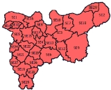
frontages and are central to London. SE2–SE18 are organised in the northern part of the postcode area, with SE2, SE7, SE8, SE10, SE16 and SE18 also fronting the river. Postcode districts SE19–SE27 form a group in the southwest and SE28 is located in the extreme northeast. The postcode area maps roughly to the combined area of the London Borough of Southwark
, London Borough of Lewisham
and London Borough of Greenwich
. Eastern sections of the London Borough of Lambeth
, the northern part of the London Borough of Croydon
(SE19, SE25) and northwestern portions of the London Borough of Bromley
(SE19, SE20, SE26) and London Borough of Bexley
(SE2, SE9, SE28) are within the postcode area.
area wished to have their postcodes changed from SE2 to the adjacent DA7 postcode district; citing higher insurance for their houses, belongings and cars as reasons to change. Royal Mail have said they will not consider changes to postcodes for these reasons.
London postal district
The London postal district is the area in England, currently of , to which mail addressed to the LONDON post town is delivered. The area was initially devised in 1856 and throughout its history has been subject to periodic reorganisation, contraction and division into increasingly smaller postal...
post town covering part of south east London
London
London is the capital city of :England and the :United Kingdom, the largest metropolitan area in the United Kingdom, and the largest urban zone in the European Union by most measures. Located on the River Thames, London has been a major settlement for two millennia, its history going back to its...
, England. It loosely corresponds to the London Borough of Southwark
London Borough of Southwark
The London Borough of Southwark is a London borough in south east London, England. It is directly south of the River Thames and the City of London, and forms part of Inner London.-History:...
, London Borough of Lewisham
London Borough of Lewisham
The London Borough of Lewisham is a London borough in south-east London, England and forms part of Inner London. The principal settlement of the borough is Lewisham...
and London Borough of Greenwich
London Borough of Greenwich
The London Borough of Greenwich is an Inner London borough in south-east London, England. Taking its name from the historic town of Greenwich, the present borough was formed in 1965 by the amalgamation of the former area of the Metropolitan Borough of Greenwich with part of the Metropolitan...
, with eastern sections of the London Borough of Lambeth
London Borough of Lambeth
The London Borough of Lambeth is a London borough in south London, England and forms part of Inner London. The local authority is Lambeth London Borough Council.-Origins:...
and smaller parts of adjoining London boroughs, But the London postal area covers a small percentage with the London Borough of Bexley
London Borough of Bexley
The London Borough of Bexley lies in south east Greater London, and is a borough referred to as part of Outer London. It has common borders with the London Borough of Bromley to the south, the London Borough of Greenwich to the west, across the River Thames to the north it borders the London...
and the London Borough of Bromley
London Borough of Bromley
The London Borough of Bromley is a London borough of south east London, England and forms part of Outer London. The principal town in the borough is Bromley.-Geography:...
.
Postal administration
The postcode area originated in 1857 as the SE district. In 1868 it gained some of the area of the abolished S district, with the rest going to SWSW postcode area
The SW postcode area, also known as the London SW postcode area, is a group of postcode districts covering part of southwest London, England. The area originates from the South Western and Battersea districts of the London post town.-Postal administration:The postcode area originated in 1857 as...
. It was divided into numbered districts in 1917, by giving the district closest to London and the location of the head office the suffix "1" and then each district assigned a number alphabetically based on the location of the main office within the district. SE28 is a much later addition carved out of the existing districts SE2 and SE18 in order to accommodate the development of Thamesmead
Thamesmead
Thamesmead is a district of south-east London, England, located in the London Boroughs of Greenwich and Bexley. It is situated east of Charing Cross....
. Unlike in the SW postcode area, where districts are also split into two alphabetical tranches, SE1 is the only head district, and although the numbering begins again at SE19 this is not a head district. The postcode area is part of the London
London postal district
The London postal district is the area in England, currently of , to which mail addressed to the LONDON post town is delivered. The area was initially devised in 1856 and throughout its history has been subject to periodic reorganisation, contraction and division into increasingly smaller postal...
post town. There are no dependent localities used in the postcode area. SE1P is a non-geographic postcode district.
List of postcode districts
The approximate coverage of the postcode districts, with the historic postal district names shown in italics:|-
! SE1
| LONDON
| South Eastern head district: Bankside
Bankside
Bankside is a district of London, England, and part of the London Borough of Southwark. Bankside is located on the southern bank of the River Thames, east of Charing Cross, running from a little west of Blackfriars Bridge to just a short distance before London Bridge at St Mary Overie Dock to...
, South Bank
South Bank
South Bank is an area of London, England located immediately adjacent to the south side of the River Thames. It forms a long and narrow section of riverside development that is within the London Borough of Lambeth to the border with the London Borough of Southwark and was formerly simply known as...
, Southwark
Southwark
Southwark is a district of south London, England, and the administrative headquarters of the London Borough of Southwark. Situated east of Charing Cross, it forms one of the oldest parts of London and fronts the River Thames to the north...
, Bermondsey
Bermondsey
Bermondsey is an area in London on the south bank of the river Thames, and is part of the London Borough of Southwark. To the west lies Southwark, to the east Rotherhithe, and to the south, Walworth and Peckham.-Toponomy:...
(part), Vauxhall
Vauxhall
-Demography:Many Vauxhall residents live in social housing. There are several gentrified areas, and areas of terraced townhouses on streets such as Fentiman Road and Heyford Avenue have higher property values in the private market, however by far the most common type of housing stock within...
(part)
| Southwark
London Borough of Southwark
The London Borough of Southwark is a London borough in south east London, England. It is directly south of the River Thames and the City of London, and forms part of Inner London.-History:...
, Lambeth
London Borough of Lambeth
The London Borough of Lambeth is a London borough in south London, England and forms part of Inner London. The local authority is Lambeth London Borough Council.-Origins:...
|-
! SE1P
| LONDON
| Non-geographic postcode district (located in SE1)
|
|-
! SE2
| LONDON
| Abbey Wood district: Abbey Wood
Abbey Wood
Abbey Wood is a district of South-East London, England, located mostly in the London Borough of Greenwich, and partly within the London Borough of Bexley. It is situated east of Charing Cross.-Development:...
, West Heath
West Heath, London
West Heath is a district located within the electoral wards of Lesnes Abbey in the London Borough of Bexley. It is located east of Charing Cross, and is on the A206 road, which is called Woolwich road in the area.-Education:-Nearest places:*Abbey Wood*Belvedere*Lessness Heath*Plumstead...
, Bexleyheath
Bexleyheath
Bexleyheath is a main suburban district of Southeast London, England, in the London Borough of Bexley with a small percentage of the district itself being in the London Borough of Greenwich. Bexleyheath is located on the border of Inner London and Outer London. It is east south-east of Charing Cross...
(small parts) Crossness
Crossness
Crossness is a place in south-east London. It is situated in the London Borough of Bexley, close to the southern bank of the River Thames, to the east of Thamesmead, west of Belvedere and north-west of Erith. The place takes its name from Cross Ness, a specific promontory on the southern bank of...
, Thamesmead
Thamesmead
Thamesmead is a district of south-east London, England, located in the London Boroughs of Greenwich and Bexley. It is situated east of Charing Cross....
(part)
| Greenwich
London Borough of Greenwich
The London Borough of Greenwich is an Inner London borough in south-east London, England. Taking its name from the historic town of Greenwich, the present borough was formed in 1965 by the amalgamation of the former area of the Metropolitan Borough of Greenwich with part of the Metropolitan...
, Bexley
London Borough of Bexley
The London Borough of Bexley lies in south east Greater London, and is a borough referred to as part of Outer London. It has common borders with the London Borough of Bromley to the south, the London Borough of Greenwich to the west, across the River Thames to the north it borders the London...
|-
! SE3
| LONDON
| Blackheath district: Blackheath
Blackheath, London
Blackheath is a district of South London, England. It is named from the large open public grassland which separates it from Greenwich to the north and Lewisham to the west...
, Kidbrooke
Kidbrooke
Kidbrooke is a district of South East London, England, located in the London Borough of Greenwich.The district takes its name from the Kyd Brook, a watercourse which runs from Orpington to Lewisham, by which point it is part of the River Quaggy...
, Westcombe Park
Westcombe Park
This article is about the London district. See Westcombe Park rugby club for details of the rugby club - now based in Orpington.Westcombe Park is a largely residential area in Blackheath in the London Borough of Greenwich, south-east London, England....
| Greenwich, Lewisham
London Borough of Lewisham
The London Borough of Lewisham is a London borough in south-east London, England and forms part of Inner London. The principal settlement of the borough is Lewisham...
|-
! SE4
| LONDON
| Brockley district: Brockley
Brockley
Brockley is a district of south London, England, located in the London Borough of Lewisham. It is situated south-east of Charing Cross.It is covered by the London postcode districts SE4 and SE14.-History:...
, Crofton Park
Crofton Park
Crofton Park is a vibrant, mainly residential suburb and electoral ward in the London Borough of Lewisham. It is the original site of the former agricultural hamlet of Brockley. It is located 5.3 miles south east of Charing Cross, and is south of Brockley and north of Honor Oak...
(part), Honor Oak
Honor Oak
Honor Oak is an inner suburban area principally of the London Borough of Lewisham, with part in The London Borough of Southwark. The name originates from Oak of Honor Hill, or One Tree Hill. The legend is that on 1 May 1602, Elizabeth I picnicked with Sir Richard Bulkeley of Beaumaris in the...
(part), Ladywell
Ladywell
Ladywell is a district of south London, England, located in the London Borough of Lewisham.-History:The name Ladywell was in use by the 15th century, and maps dating to this period show the site of the original Ladywell, in front of the area later to be occupied by the Freemason's Arms and...
(part)
| Lewisham
|-
! SE5
| LONDON
| Camberwell district: Camberwell
Camberwell
Camberwell is a district of south London, England, and forms part of the London Borough of Southwark. It is a built-up inner city district located southeast of Charing Cross. To the west it has a boundary with the London Borough of Lambeth.-Toponymy:...
, Denmark Hill
Denmark Hill
Denmark Hill is an area and road in the London Borough of Southwark. The road forms part of the A215; north of Camberwell Green it becomes Camberwell Road; south of Red Post Hill it becomes Herne Hill. Its postcode is SE5. Nearby streets whose names refer to different aspects of the same...
, Peckham
Peckham
Peckham is a district in south London, England, located in the London Borough of Southwark. It is situated south-east of Charing Cross. The area is identified in the London Plan as one of 35 major centres in Greater London...
| Lambeth, Southwark
|-
! SE6
| LONDON
| Catford district: Catford
Catford
Catford is a district in south London, England, located in the London Borough of Lewisham. It is situated south-east of Charing Cross. The area is identified in the London Plan as one of 35 major centres in Greater London.-Architecture:...
, Bellingham
Bellingham, London
Bellingham is a neighbourhood and electoral ward in the London Borough of Lewisham, and consists mainly of social/council housing built in the 1920s on what was then farm land. Many houses have been bought by the tenants under the Right to Buy Scheme. However, the majority are still rented out to...
, Hither Green
Hither Green
Hither Green is a district in south east London, England, located in the London Borough of Lewisham. It is situated 6.6 miles south east of Charing Cross, and on the Prime Meridian....
(part)
| Lewisham
|-
! SE7
| LONDON
| Charlton district: Charlton
Charlton, London
Charlton is a district of south London, England, and part of the London Borough of Greenwich. It is located east-southeast of Charing Cross. Charlton next Woolwich was an ancient parish in the county of Kent, which became part of the metropolitan area of London in 1855. It is home to Charlton...
| Greenwich
|-
! SE8
| LONDON
| Deptford district: Deptford
Deptford
Deptford is a district of south London, England, located on the south bank of the River Thames. It is named after a ford of the River Ravensbourne, and from the mid 16th century to the late 19th was home to Deptford Dockyard, the first of the Royal Navy Dockyards.Deptford and the docks are...
, Evelyn
| Lewisham, Greenwich, Southwark
|-
! SE9
| LONDON
| Eltham district: Eltham
Eltham, London
-Parks and open spaces:There is a large variety of open green space in Eltham, in the form of parkland, fields and woodland.*Avery Hill Park is large, open parkland, situated to the east of Eltham. It is most notable for its Winter Garden, a hothouse containing tropical trees and plants from around...
, Mottingham
Mottingham
Mottingham is a district of south London, England; located at the convergence of the London Borough of Bromley, the London Borough of Lewisham and the London Borough of Greenwich...
, New Eltham
New Eltham
New Eltham is a commuter suburb in the London Borough of Greenwich, England, although the Dulverton catchment area to the North side of Footscray Road falls within the London Borough of Bexley....
, Falconwood
Falconwood
-Southeastern Train Services:Nearest Train Stations* Falconwood railway station, Lingfield Crescent, Eltham, London, SE9 2RN.* Eltham railway station, Well Hall Road, Eltham, London, SE9 6SL....
(part), Chinbrook
Chinbrook
Chinbrook is a suburb in southeast London; it is located southeast of Charing Cross and is in the southeast corner of the London Borough of Lewisham on its boundary with the London Borough of Bromley...
(part), Longlands
Longlands
Longlands is a place and suburb in southeast London, England, that straddles the boundaries of three London Boroughs, Bromley, Greenwich, and Bexley. In the London Borough of Bexley, Longlands is the name of the electoral ward that covers the southwest corner of that borough. Longlands has three...
(part) Kidbrooke
Kidbrooke
Kidbrooke is a district of South East London, England, located in the London Borough of Greenwich.The district takes its name from the Kyd Brook, a watercourse which runs from Orpington to Lewisham, by which point it is part of the River Quaggy...
(part), Shooter's Hill
Shooter's Hill
Shooter's Hill is a district and electoral ward in south London, England, located in the London Borough of Greenwich. It lies east of Blackheath and west of Welling, south of Woolwich and north of Eltham...
(part) Sidcup
Sidcup
Sidcup is a district in South East London in the London Borough of Bexley and small parts of the district in the London Borough of Greenwich.Located south east of Charing Cross, Sidcup is bordered by the London Boroughs of Greenwich and Bromley and Kent County Council, and whilst now part of...
(small parts for 2012)
| Greenwich, Lewisham, Bexley, Bromley
London Borough of Bromley
The London Borough of Bromley is a London borough of south east London, England and forms part of Outer London. The principal town in the borough is Bromley.-Geography:...
|-
! SE10
| LONDON
| Greenwich district: Greenwich
Greenwich
Greenwich is a district of south London, England, located in the London Borough of Greenwich.Greenwich is best known for its maritime history and for giving its name to the Greenwich Meridian and Greenwich Mean Time...
, Maze Hill
Maze Hill
Maze Hill is an area in Greenwich and Blackheath, in south-east London, lying to the east of Greenwich Park, and west of the Westcombe Park area of Blackheath. It is part of the London Borough of Greenwich, and takes its name from the main thoroughfare, Maze Hill...
, Greenwich Peninsula
Greenwich Peninsula
Greenwich Peninsula is an area of South London, England, located in the London Borough of Greenwich.The peninsula is bounded on three sides by a loop of the Thames, between the Isle of Dogs and Silvertown. To the south is the rest of Greenwich, to the south-east is Charlton.The peninsula lies...
| Greenwich, Lewisham
|-
! SE11
| LONDON
| Kennington district: Kennington
Kennington
Kennington is a district of South London, England, mainly within the London Borough of Lambeth, although part of the area is within the London Borough of Southwark....
, Vauxhall
Vauxhall
-Demography:Many Vauxhall residents live in social housing. There are several gentrified areas, and areas of terraced townhouses on streets such as Fentiman Road and Heyford Avenue have higher property values in the private market, however by far the most common type of housing stock within...
(part)
| Lambeth, Southwark
|-
! SE12
| LONDON
| Lee district: Lee
Lee, London
Lee is a district of south London, England, located mostly in the London Borough of Lewisham and partly in the London Borough of Greenwich. The district lies to the east of Lewisham, one mile west of Eltham, and one mile south of Blackheath village...
, Grove Park, Chinbrook
Chinbrook
Chinbrook is a suburb in southeast London; it is located southeast of Charing Cross and is in the southeast corner of the London Borough of Lewisham on its boundary with the London Borough of Bromley...
, Hither Green
Hither Green
Hither Green is a district in south east London, England, located in the London Borough of Lewisham. It is situated 6.6 miles south east of Charing Cross, and on the Prime Meridian....
(part), Eltham
Eltham, London
-Parks and open spaces:There is a large variety of open green space in Eltham, in the form of parkland, fields and woodland.*Avery Hill Park is large, open parkland, situated to the east of Eltham. It is most notable for its Winter Garden, a hothouse containing tropical trees and plants from around...
(part), Horn Park
Horn Park
-History:Horn Park was one of three parks attached to Eltham Palace. The area was heavily wooded and was stocked with deer until the destruction of both during the English Civil War. The park became farmland until 1936 when the Metropolitan Borough of Woolwich began the construction of the Horn...
, Blackheath
Blackheath, London
Blackheath is a district of South London, England. It is named from the large open public grassland which separates it from Greenwich to the north and Lewisham to the west...
(part)
| Lewisham, Greenwich
|-
! SE13
| LONDON
| Lewisham district: Lewisham
Lewisham
Lewisham is a district in South London, England, located in the London Borough of Lewisham. It is situated south-east of Charing Cross. The area is identified in the London Plan as one of 35 major centres in Greater London.-History:...
, Hither Green
Hither Green
Hither Green is a district in south east London, England, located in the London Borough of Lewisham. It is situated 6.6 miles south east of Charing Cross, and on the Prime Meridian....
, Ladywell
Ladywell
Ladywell is a district of south London, England, located in the London Borough of Lewisham.-History:The name Ladywell was in use by the 15th century, and maps dating to this period show the site of the original Ladywell, in front of the area later to be occupied by the Freemason's Arms and...
| Lewisham, Greenwich
|-
! SE14
| LONDON
| New Cross district: New Cross
New Cross
New Cross is a district and ward of the London Borough of Lewisham, England. It is situated 4 miles south-east of Charing Cross. The ward covered by London post town and the SE 14 postcode district. New Cross is near St Johns, Telegraph Hill, Nunhead, Peckham, Brockley, Deptford and Greenwich...
| Lewisham
|-
! SE15
| LONDON
| Peckham district: Peckham
Peckham
Peckham is a district in south London, England, located in the London Borough of Southwark. It is situated south-east of Charing Cross. The area is identified in the London Plan as one of 35 major centres in Greater London...
, Nunhead
Nunhead
Nunhead is a place in the London Borough of Southwark in London, England. It is an inner-city suburb located southeast of Charing Cross. It is the location of the Nunhead Cemetery. Nunhead has traditionally been a working-class area and, with the adjacent neighbourhoods, is currently going...
| Southwark, Lewisham
|-
! SE16
| LONDON
| Rotherhithe district: Rotherhithe
Rotherhithe
Rotherhithe is a residential district in inner southeast London, England and part of the London Borough of Southwark. It is located on a peninsula on the south bank of the Thames, facing Wapping and the Isle of Dogs on the north bank, and is a part of the Docklands area...
, Bermondsey
Bermondsey
Bermondsey is an area in London on the south bank of the river Thames, and is part of the London Borough of Southwark. To the west lies Southwark, to the east Rotherhithe, and to the south, Walworth and Peckham.-Toponomy:...
(part), Surrey Quays
Surrey Quays
Surrey Quays is a name given to a largely residential area of Rotherhithe in south-east London, occupied until 1970 by the Surrey Commercial Docks...
| Southwark, Lewisham
|-
! SE17
| LONDON
| Walworth district: Walworth
Walworth, London
Walworth is an inner-city district in the London Borough of Southwark. Walworth probably derives its name from the Old English "Wealhworth" which meant Welsh farm. It is located south east of Charing Cross and near to Camberwell and Elephant and Castle.The major streets in Walworth are the Old...
, Newington
Newington, London
Newington is a district of London, England, and part of the London Borough of Southwark. It was an ancient parish and the site of the early administration of the county of Surrey...
| Southwark
|-
! SE18
| LONDON
| Woolwich district: Woolwich
Woolwich
Woolwich is a district in south London, England, located in the London Borough of Greenwich. The area is identified in the London Plan as one of 35 major centres in Greater London.Woolwich formed part of Kent until 1889 when the County of London was created...
, Plumstead
Plumstead
Plumstead is a district of south London, England, located in the London Borough of Greenwich. Plumstead is a multi cultural area with large Asian and Afro-Caribbean communities, in similarity to local areas such as Woolwich and Thamesmead...
, Shooter's Hill
Shooter's Hill
Shooter's Hill is a district and electoral ward in south London, England, located in the London Borough of Greenwich. It lies east of Blackheath and west of Welling, south of Woolwich and north of Eltham...
| Greenwich, Bexley
|-
! SE19
| LONDON
| Upper Norwood district: Upper Norwood
Upper Norwood
Upper Norwood is an elevated area in south London, England within the postcode SE19. It is a residential district largely in the London Borough of Croydon although some parts extend into the London Borough of Lambeth, London Borough of Southwark and the London Borough of Bromley. Upper Norwood...
, Crystal Palace
Crystal Palace, London
Crystal Palace is a residential area in south London, England named from the former local landmark, The Crystal Palace, which occupied the area from 1854 to 1936. The area is located approximately 8 miles south east of Charing Cross, and offers impressive views over the capital...
,
| Croydon
London Borough of Croydon
The London Borough of Croydon is a London borough in South London, England and is part of Outer London. It covers an area of and is the largest London borough by population. It is the southernmost borough of London. At its centre is the historic town of Croydon from which the borough takes its name...
, Lambeth, Bromley, Southwark, Lewisham
|-
! SE20
| LONDON
| Anerley district: Anerley
Anerley
Anerley is a district of South London, England, located in the London Borough of Bromley. It is situated south south-east of Charing Cross. Anerley is geographically an outer lying area of London, although it is considered to have characteristics of an Inner city suburb...
, Crystal Palace (part), Penge
Penge
Penge is a suburb of London in the London Borough of Bromley. It is located south east of Charing Cross.-History:Penge was once a small town, which was recorded under the name Penceat in a Saxon deed dating from 957...
, Beckenham
Beckenham
Beckenham is a town in the London Borough of Bromley, England. It is located 8.4 miles south east of Charing Cross and 1.75 miles west of Bromley town...
(part)
| Bromley
|-
! SE21
| LONDON
| Dulwich district: Dulwich
Dulwich
Dulwich is an area of South London, England. The settlement is mostly in the London Borough of Southwark with parts in the London Borough of Lambeth...
, Dulwich Village
Dulwich Village
Dulwich Village is an area of Dulwich in South London's SE21 postcode area in England. It is located in the London Borough of Southwark."Dulwich Village" is also the name of one of the High Streets in the area. Residents in Dulwich Village have to pay ground rent to the Dulwich Estate a landowning...
, West Dulwich
West Dulwich
West Dulwich is an area in southeast London, England, that straddles the London Borough of Lambeth and the London Borough of Southwark. Croxted Road and South Croxted Road mark the boundary between London Borough of Southwark on the east and London Borough of Lambeth to the west...
, Tulse Hill (part), Sydenham Hill
Sydenham Hill
For other uses of 'Sydenham', see Sydenham .Sydenham Hill is a hill or ridge and a locality in South-East London and the name of a road which runs along the northern eastern part of the ridge and forms the boundary between the London Borough of Southwark and the London Borough of Lewisham. The...
(part)
| Southwark, Lambeth
|-
! SE22
| LONDON
| East Dulwich district: East Dulwich
East Dulwich
East Dulwich is a district of South London, England in the London Borough of Southwark. It forms the eastern one third of Dulwich, with the Dulwich Wood area, Dulwich Village and West Dulwich to its South and West making up the remaining two thirds...
, Peckham Rye, Loughborough Junction
Loughborough Junction
Loughborough Junction is an area of South London, in the Borough of Lambeth, which lies on the borderline of Brixton and Camberwell. It is centred at a junction which consists of 6 railway bridges which can all be seen at once from the centre of the junction. Loughborough Junction can be found...
, Herne Hill
Herne Hill
Herne Hill is located in the London Borough of Lambeth and the London Borough of Southwark in Greater London. There is a road of the same name which continues the A215 north of Norwood Road and was called Herne Hill Road.-History:...
| Southwark
|-
! SE23
| LONDON
| Forest Hill district: Forest Hill
Forest Hill, London
Forest Hill is a district of south London, England, located in the London Borough of Lewisham. It situated between Dulwich and Sydenham. The area has enjoyed extensive investment since plans to extend the East London Line to Forest Hill were unveiled in 2004....
, Honor Oak
Honor Oak
Honor Oak is an inner suburban area principally of the London Borough of Lewisham, with part in The London Borough of Southwark. The name originates from Oak of Honor Hill, or One Tree Hill. The legend is that on 1 May 1602, Elizabeth I picnicked with Sir Richard Bulkeley of Beaumaris in the...
, Crofton Park
Crofton Park
Crofton Park is a vibrant, mainly residential suburb and electoral ward in the London Borough of Lewisham. It is the original site of the former agricultural hamlet of Brockley. It is located 5.3 miles south east of Charing Cross, and is south of Brockley and north of Honor Oak...
(part)
| Lewisham, Southwark
|-
! SE24
| LONDON
| Herne Hill district: Herne Hill
Herne Hill
Herne Hill is located in the London Borough of Lambeth and the London Borough of Southwark in Greater London. There is a road of the same name which continues the A215 north of Norwood Road and was called Herne Hill Road.-History:...
, Tulse Hill (part)
| Lambeth, Southwark
|-
! SE25
| LONDON
| South Norwood district: South Norwood
South Norwood
South Norwood is an urban town and in south London, England, in the London Borough of Croydon. It is a suburban development 7.8 miles south-east of Charing Cross. South Norwood is an electoral with a resident population in 2001 of just over 14,000...
, Selhurst
Selhurst
Selhurst is a suburban development in the London Borough of Croydon south-south-east of Charing Cross. A relatively small area, Selhurst is bounded by South Norwood, Croydon and Thornton Heath and, like nearby Broad Green, has lost its distinct identity from these larger neighbours in recent years...
| Croydon
|-
! SE26
| LONDON
| Sydenham district: Sydenham
Sydenham
Sydenham is an area and electoral ward in the London Borough of Lewisham; although some streets towards Crystal Palace Park, Forest Hill and Penge are outside the ward and in the London Borough of Bromley, and some streets off Sydenham Hill are in the London Borough of Southwark. Sydenham was in...
, Crystal Palace (part)
| Bromley, Lewisham, Southwark
|-
! SE27
| LONDON
| West Norwood district: West Norwood
West Norwood
West Norwood is a place in the London Borough of Lambeth.It is primarily a residential suburb of south London but with some light industry near Knights Hill in the south....
, Gipsy Hill
Gipsy Hill
Gipsy Hill is an area of South London near Upper Norwood, it is considered to be part of Crystal Palace. This area of Gipsy Hill also includes the Central Hill estate...
(part), Norwood (part)
| Lambeth
|-
! SE28
| LONDON
| Thamesmead district: Thamesmead
Thamesmead
Thamesmead is a district of south-east London, England, located in the London Boroughs of Greenwich and Bexley. It is situated east of Charing Cross....
| Greenwich, Bexley
|-
! SE99
| LONDON
| Non-geographic postcode district (located in SE1–SE22)
|
|}
Boundaries
Postcode districts SE1 and SE11 have extensive River ThamesRiver Thames
The River Thames flows through southern England. It is the longest river entirely in England and the second longest in the United Kingdom. While it is best known because its lower reaches flow through central London, the river flows alongside several other towns and cities, including Oxford,...
frontages and are central to London. SE2–SE18 are organised in the northern part of the postcode area, with SE2, SE7, SE8, SE10, SE16 and SE18 also fronting the river. Postcode districts SE19–SE27 form a group in the southwest and SE28 is located in the extreme northeast. The postcode area maps roughly to the combined area of the London Borough of Southwark
London Borough of Southwark
The London Borough of Southwark is a London borough in south east London, England. It is directly south of the River Thames and the City of London, and forms part of Inner London.-History:...
, London Borough of Lewisham
London Borough of Lewisham
The London Borough of Lewisham is a London borough in south-east London, England and forms part of Inner London. The principal settlement of the borough is Lewisham...
and London Borough of Greenwich
London Borough of Greenwich
The London Borough of Greenwich is an Inner London borough in south-east London, England. Taking its name from the historic town of Greenwich, the present borough was formed in 1965 by the amalgamation of the former area of the Metropolitan Borough of Greenwich with part of the Metropolitan...
. Eastern sections of the London Borough of Lambeth
London Borough of Lambeth
The London Borough of Lambeth is a London borough in south London, England and forms part of Inner London. The local authority is Lambeth London Borough Council.-Origins:...
, the northern part of the London Borough of Croydon
London Borough of Croydon
The London Borough of Croydon is a London borough in South London, England and is part of Outer London. It covers an area of and is the largest London borough by population. It is the southernmost borough of London. At its centre is the historic town of Croydon from which the borough takes its name...
(SE19, SE25) and northwestern portions of the London Borough of Bromley
London Borough of Bromley
The London Borough of Bromley is a London borough of south east London, England and forms part of Outer London. The principal town in the borough is Bromley.-Geography:...
(SE19, SE20, SE26) and London Borough of Bexley
London Borough of Bexley
The London Borough of Bexley lies in south east Greater London, and is a borough referred to as part of Outer London. It has common borders with the London Borough of Bromley to the south, the London Borough of Greenwich to the west, across the River Thames to the north it borders the London...
(SE2, SE9, SE28) are within the postcode area.
Adjacent areas
In 2002, a small group of residents in the West HeathWest Heath, London
West Heath is a district located within the electoral wards of Lesnes Abbey in the London Borough of Bexley. It is located east of Charing Cross, and is on the A206 road, which is called Woolwich road in the area.-Education:-Nearest places:*Abbey Wood*Belvedere*Lessness Heath*Plumstead...
area wished to have their postcodes changed from SE2 to the adjacent DA7 postcode district; citing higher insurance for their houses, belongings and cars as reasons to change. Royal Mail have said they will not consider changes to postcodes for these reasons.