
London postal district
Encyclopedia
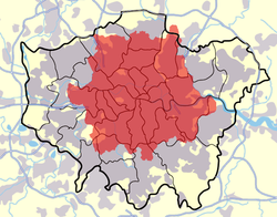
The London postal district is the area in England
, currently of 241 square miles (624.2 km²), to which mail addressed to the LONDON post town
is delivered. The area was initially devised in 1856 and throughout its history has been subject to periodic reorganisation, contraction and division into increasingly smaller postal units. It was integrated into the national postcode system of the United Kingdom during the early 1970s and now corresponds to the N, NW, SW, SE, W, WC, E and EC postcode areas. The postal district has also been known as the London postal area and as the inner area
of the London postal region.
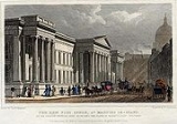
.jpg) By the 1850s, the rapid growth of the metropolitan area meant it became too large to efficiently operate as a single post town. A Post Office inquiry into the problem had been set up in 1837 and a House of Commons
By the 1850s, the rapid growth of the metropolitan area meant it became too large to efficiently operate as a single post town. A Post Office inquiry into the problem had been set up in 1837 and a House of Commons
committee was initiated in 1843. In 1854 Charles Canning
, the Postmaster General
, set up a committee at the Post Office in St. Martin's Le Grand to investigate how London could best be divided for the purposes of directing mail. In 1856, of the 470 million items of mail sent in the United Kingdom during the year, approximately one fifth (100 million) were for delivery in London and half of these (50 million items) also originated there.
The original London postal district was devised by Sir Rowland Hill
in 1856 as a circular area of 12 miles (19.3 km) radius from the central post office at St. Martin's Le Grand
, near St Paul's Cathedral
in central London. As originally devised, it extended from Waltham Cross
in the north, to Carshalton
in the south and from Romford
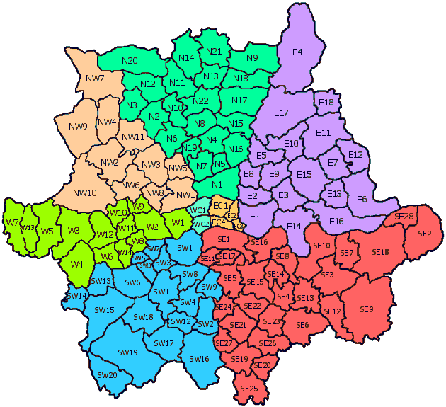
in the east to Southall
in the west. Within the district it was divided into ten large areas which operated much like separate towns. Each was constituted "London" with a suffix (EC, WC, N, NE, E, SE, S, SW, W, and NW) indicating the area it covered; each had a separate head office. The system was introduced during 1857 and was completed on 1 January 1858.
. In 1866 NE was merged into the E district, transferring places such as Walthamstow
, Wanstead
and Leytonstone
. Also at this time the outer boundary was retracted in the east, removing places such as Great Ilford
from the postal district altogether. In 1868 the S district was split between SE and SW. The NE and S codes have been re-used in the national postcode system and now refer to the NE postcode area
around Newcastle upon Tyne
and the S postcode area
around Sheffield
.
from existing districts because of the construction of the high density Thamesmead
development.
and SW1
.
 The initial system was designed at a time when the official London boundary was restricted to the square mile of the small ancient City of London
. The wider metropolitan postal area covered parts of the counties of Middlesex
, Surrey
, Kent
, Essex
and Hertfordshire
. In 1889 a County of London
was created which was somewhat smaller than the postal district. Around 40 of the sub-districts created in 1917 were outside its boundary with Leyton
in Essex, Ealing
in Middlesex, Totteridge
in Hertfordshire and Wimbledon
in Surrey served by the London postal area but outside the County of London.
In 1965 the creation of Greater London
caused London's boundary to expand to include these places for local government as well as postal purposes. However the new boundary went far beyond these postal districts. Royal Mail
were unable to follow this change and expand the postal district to match because of the prohibitive cost. Places in London's outer boroughs such as Harrow
, Barnet, Enfield
, Ilford
, Romford
, Bexleyheath
, Bromley
, Hounslow
, Richmond and Croydon
are therefore covered by parts of twelve adjoining postcode areas (EN, IG, RM, DA, BR, TN
, CR, SM, KT, TW, HA and UB), formerly in five postal counties. Royal Mail now has a policy of changing postcodes only if there is an operational advantage to them and has no plan to change the postcode system to correlate with the London boundary. In 2003 the then Mayor of London expressed support for revision of postal addresses in Greater London.
The London postal district currently includes all of the City of London
, Camden
, Hackney
, Hammersmith and Fulham
, Haringey
, Islington
, Kensington and Chelsea
, Southwark
, Tower Hamlets
, Wandsworth
and Westminster
. Almost entirely included are Greenwich
, Lambeth
, Lewisham
, Newham
and Waltham Forest
, except for a few streets. Barnet
, Bexley
, Brent
, Bromley
, Croydon
, Ealing
, Enfield
, Harrow
, Hounslow
, Kingston upon Thames
, Merton
, Redbridge
and Richmond upon Thames
are partly in the postal district. Barking and Dagenham
, Havering
, Hillingdon
and Sutton
are completely outside the postal district. Sewardstone
in the Epping Forest
district of Essex
is anomalously the only place to be outside the Greater London boundary but within the London postal district.
) or raise the prestige of their business (see IG1). This is generally futile as Royal Mail only changes postcodes in order to facilitate the delivery of post.
'LONDON' and full stops were commonly placed after each character, e.g. LONDON S.W.1.
Use of the full stops ended with the implementation of the national postcode system. In addition, integration of the London postal districts into postcodes means that the postal district should now appear on a separate line, in line with other postcodes in the national system.
Maps, photos, and other images
England
England is a country that is part of the United Kingdom. It shares land borders with Scotland to the north and Wales to the west; the Irish Sea is to the north west, the Celtic Sea to the south west, with the North Sea to the east and the English Channel to the south separating it from continental...
, currently of 241 square miles (624.2 km²), to which mail addressed to the LONDON post town
Post town
A post town is a required part of all postal addresses in the United Kingdom, and a basic unit of the postal delivery system. Including the correct post town in the address increases the chances of a letter or parcel being delivered on time. Post towns are usually based upon the location of...
is delivered. The area was initially devised in 1856 and throughout its history has been subject to periodic reorganisation, contraction and division into increasingly smaller postal units. It was integrated into the national postcode system of the United Kingdom during the early 1970s and now corresponds to the N, NW, SW, SE, W, WC, E and EC postcode areas. The postal district has also been known as the London postal area and as the inner area
Inner London
Inner London is the name for the group of London boroughs which form the interior part of Greater London and are surrounded by Outer London. The area was first officially defined in 1965 and for purposes such as statistics, the definition has changed over time. The terms Inner London and Central...
of the London postal region.
Origins
British House of Commons
The House of Commons is the lower house of the Parliament of the United Kingdom, which also comprises the Sovereign and the House of Lords . Both Commons and Lords meet in the Palace of Westminster. The Commons is a democratically elected body, consisting of 650 members , who are known as Members...
committee was initiated in 1843. In 1854 Charles Canning
Charles Canning, 1st Earl Canning
Charles John Canning, 1st Earl Canning KG, GCB, PC , known as The Viscount Canning from 1837 to 1859, was an English statesman and Governor-General of India during the Indian Rebellion of 1857.-Background and education:...
, the Postmaster General
United Kingdom Postmaster General
The Postmaster General of the United Kingdom is a defunct Cabinet-level ministerial position in HM Government. Aside from maintaining the postal system, the Telegraph Act of 1868 established the Postmaster General's right to exclusively maintain electric telegraphs...
, set up a committee at the Post Office in St. Martin's Le Grand to investigate how London could best be divided for the purposes of directing mail. In 1856, of the 470 million items of mail sent in the United Kingdom during the year, approximately one fifth (100 million) were for delivery in London and half of these (50 million items) also originated there.
The original London postal district was devised by Sir Rowland Hill
Rowland Hill (postal reformer)
Sir Rowland Hill KCB, FRS was an English teacher, inventor and social reformer. He campaigned for a comprehensive reform of the postal system, based on the concept of penny postage and his solution of prepayment, facilitating the safe, speedy and cheap transfer of letters...
in 1856 as a circular area of 12 miles (19.3 km) radius from the central post office at St. Martin's Le Grand
St. Martin's Le Grand
St Martin’s le Grand is a street and former liberty in the City of London between Newgate Street and Cheapside to the south and Aldersgate Street and London Wall to the north. To the east of the road once stood the collegiate church and monastic precinct of St Martin's, of ancient origin...
, near St Paul's Cathedral
St Paul's Cathedral
St Paul's Cathedral, London, is a Church of England cathedral and seat of the Bishop of London. Its dedication to Paul the Apostle dates back to the original church on this site, founded in AD 604. St Paul's sits at the top of Ludgate Hill, the highest point in the City of London, and is the mother...
in central London. As originally devised, it extended from Waltham Cross
Waltham Cross
Waltham Cross is the most southeasterly town in Hertfordshire, England. It is 12 miles from the City of London and immediately north of the M25 motorway, forming part of the Greater London Urban Area and London commuter belt. Part of Waltham Cross is located within Greater London.-Geography:It is...
in the north, to Carshalton
Carshalton
Carshalton is a suburban area of the London Borough of Sutton, England. It is located 10 miles south-southwest of Charing Cross, situated in the valley of the River Wandle, one of the sources of which is Carshalton Ponds in the centre of the village. The combined population of the five wards...
in the south and from Romford
Romford
Romford is a large suburban town in north east London, England and the administrative headquarters of the London Borough of Havering. It is located northeast of Charing Cross and is one of the major metropolitan centres identified in the London Plan...
in the east to Southall
Southall
Southall is a large suburban district of west London, England, and part of the London Borough of Ealing. It is situated west of Charing Cross. Neighbouring places include Yeading, Hayes, Hanwell, Heston, Hounslow, Greenford and Northolt...
in the west. Within the district it was divided into ten large areas which operated much like separate towns. Each was constituted "London" with a suffix (EC, WC, N, NE, E, SE, S, SW, W, and NW) indicating the area it covered; each had a separate head office. The system was introduced during 1857 and was completed on 1 January 1858.
Changes to NE and S
The NE and S divisions were abolished following a report by Anthony TrollopeAnthony Trollope
Anthony Trollope was one of the most successful, prolific and respected English novelists of the Victorian era. Some of his best-loved works, collectively known as the Chronicles of Barsetshire, revolve around the imaginary county of Barsetshire...
. In 1866 NE was merged into the E district, transferring places such as Walthamstow
Walthamstow
Walthamstow is a district of northeast London, England, located in the London Borough of Waltham Forest. It is situated north-east of Charing Cross...
, Wanstead
Wanstead
Wanstead is a suburban area in the London Borough of Redbridge, North-East London. The main road going through Wanstead is the A12. The name is from the Anglo-Saxon words wænn and stede, meaning "settlement on a small hill"....
and Leytonstone
Leytonstone
Leytonstone is an area of east London and part of the London Borough of Waltham Forest. It is a high density suburban area, located seven miles north east of Charing Cross in the ceremonial county of Greater London and the historic county of Essex...
. Also at this time the outer boundary was retracted in the east, removing places such as Great Ilford
Ilford
Ilford is a large cosmopolitan town in East London, England and the administrative headquarters of the London Borough of Redbridge. It is located northeast of Charing Cross and is one of the major metropolitan centres identified in the London Plan. It forms a significant commercial and retail...
from the postal district altogether. In 1868 the S district was split between SE and SW. The NE and S codes have been re-used in the national postcode system and now refer to the NE postcode area
NE postcode area
The NE postcode area, also known as the Newcastle upon Tyne postcode area, is a group of postcode districts around Alnwick, Ashington, Bamburgh, Bedlington, Belford, Blaydon-on-Tyne, Blyth, Boldon Colliery, Chathill, Choppington, Corbridge, Cramlington, East Boldon, Gateshead, Haltwhistle, Hebburn,...
around Newcastle upon Tyne
Newcastle upon Tyne
Newcastle upon Tyne is a city and metropolitan borough of Tyne and Wear, in North East England. Historically a part of Northumberland, it is situated on the north bank of the River Tyne...
and the S postcode area
S postcode area
The S postcode area, also known as the Sheffield postcode area, is a group of postcode districts around Barnsley, Chesterfield, Dronfield, Hope Valley, Mexborough, Rotherham, Sheffield and Worksop in England....
around Sheffield
Sheffield
Sheffield is a city and metropolitan borough of South Yorkshire, England. Its name derives from the River Sheaf, which runs through the city. Historically a part of the West Riding of Yorkshire, and with some of its southern suburbs annexed from Derbyshire, the city has grown from its largely...
.
Numbered divisions
In 1917, as a wartime measure to improve efficiency, the districts were further subdivided with a number applied to each sub-district. This was achieved by designating the area served directly by the head office in each district "1" and then allocating the rest alphabetically by the name of the location of each delivery office. Exceptionally, W2 and SW11 are also 'head districts'. The boundaries of each sub-district rarely correspond to any units of civil administration such as parishes or boroughs; despite this they have developed over time into a primary reference frame. The numbered sub-districts were later used as the outward code (first half) of the postcode system implemented during the 1970s. There have been a number of ad-hoc changes to the organisation of the districts, such as the creation of SE28SE postcode area
The SE postcode area, also known as the London SE postcode area, is the part of the London post town covering part of south east London, England...
from existing districts because of the construction of the high density Thamesmead
Thamesmead
Thamesmead is a district of south-east London, England, located in the London Boroughs of Greenwich and Bexley. It is situated east of Charing Cross....
development.
High density districts
Due to heavier demand, some high density postcode districts have been split to create new, smaller postcode districts. This is achieved by adding a letter after the original postcode district, for example W1P. Where districts are used for purposes other than the sorting of mail, such as use as a geographic reference and on street signs, the subdivisions continue to be classed as one 'district'. The districts that have been subdivided are E1, W1, EC1, EC2, EC3, EC4, WC1, WC2WC postcode area
The WC postcode area, also known as the London WC postcode area, is a group of postcode districts in central London, England. It includes parts of the London Borough of Camden, City of Westminster, London Borough of Islington and a very small part of the City of London. The area covered is of...
and SW1
SW postcode area
The SW postcode area, also known as the London SW postcode area, is a group of postcode districts covering part of southwest London, England. The area originates from the South Western and Battersea districts of the London post town.-Postal administration:The postcode area originated in 1857 as...
.
Relationship to London boundary
City of London
The City of London is a small area within Greater London, England. It is the historic core of London around which the modern conurbation grew and has held city status since time immemorial. The City’s boundaries have remained almost unchanged since the Middle Ages, and it is now only a tiny part of...
. The wider metropolitan postal area covered parts of the counties of Middlesex
Middlesex
Middlesex is one of the historic counties of England and the second smallest by area. The low-lying county contained the wealthy and politically independent City of London on its southern boundary and was dominated by it from a very early time...
, Surrey
Surrey
Surrey is a county in the South East of England and is one of the Home Counties. The county borders Greater London, Kent, East Sussex, West Sussex, Hampshire and Berkshire. The historic county town is Guildford. Surrey County Council sits at Kingston upon Thames, although this has been part of...
, Kent
Kent
Kent is a county in southeast England, and is one of the home counties. It borders East Sussex, Surrey and Greater London and has a defined boundary with Essex in the middle of the Thames Estuary. The ceremonial county boundaries of Kent include the shire county of Kent and the unitary borough of...
, Essex
Essex
Essex is a ceremonial and non-metropolitan county in the East region of England, and one of the home counties. It is located to the northeast of Greater London. It borders with Cambridgeshire and Suffolk to the north, Hertfordshire to the west, Kent to the South and London to the south west...
and Hertfordshire
Hertfordshire
Hertfordshire is a ceremonial and non-metropolitan county in the East region of England. The county town is Hertford.The county is one of the Home Counties and lies inland, bordered by Greater London , Buckinghamshire , Bedfordshire , Cambridgeshire and...
. In 1889 a County of London
County of London
The County of London was a county of England from 1889 to 1965, corresponding to the area known today as Inner London. It was created as part of the general introduction of elected county government in England, by way of the Local Government Act 1888. The Act created an administrative County of...
was created which was somewhat smaller than the postal district. Around 40 of the sub-districts created in 1917 were outside its boundary with Leyton
Leyton
Leyton is an area of north-east London and part of the London Borough of Waltham Forest, located north east of Charing Cross. It borders Walthamstow and Leytonstone; Stratford in Newham; and Homerton and Lower Clapton in the London Borough of Hackney....
in Essex, Ealing
Ealing
Ealing is a suburban area of west London, England and the administrative centre of the London Borough of Ealing. It is located west of Charing Cross and around from the City of London. It is one of the major metropolitan centres identified in the London Plan. It was historically a rural village...
in Middlesex, Totteridge
Totteridge
Totteridge is an area of the London Borough of Barnet in north London, England. It is a mixture of suburban development and open land situated 8.20 miles north north-west of Charing Cross....
in Hertfordshire and Wimbledon
Wimbledon, London
Wimbledon is a district in the south west area of London, England, located south of Wandsworth, and east of Kingston upon Thames. It is situated within Greater London. It is home to the Wimbledon Tennis Championships and New Wimbledon Theatre, and contains Wimbledon Common, one of the largest areas...
in Surrey served by the London postal area but outside the County of London.
In 1965 the creation of Greater London
Greater London
Greater London is the top-level administrative division of England covering London. It was created in 1965 and spans the City of London, including Middle Temple and Inner Temple, and the 32 London boroughs. This territory is coterminate with the London Government Office Region and the London...
caused London's boundary to expand to include these places for local government as well as postal purposes. However the new boundary went far beyond these postal districts. Royal Mail
Royal Mail
Royal Mail is the government-owned postal service in the United Kingdom. Royal Mail Holdings plc owns Royal Mail Group Limited, which in turn operates the brands Royal Mail and Parcelforce Worldwide...
were unable to follow this change and expand the postal district to match because of the prohibitive cost. Places in London's outer boroughs such as Harrow
Harrow, London
Harrow is an area in the London Borough of Harrow, northwest London, United Kingdom. It is a suburban area and is situated 12.2 miles northwest of Charing Cross...
, Barnet, Enfield
Enfield Town
Enfield Town is the historic town centre of Enfield, formerly in the county of Middlesex and now in the London Borough of Enfield. It is north north-east of Charing Cross...
, Ilford
Ilford
Ilford is a large cosmopolitan town in East London, England and the administrative headquarters of the London Borough of Redbridge. It is located northeast of Charing Cross and is one of the major metropolitan centres identified in the London Plan. It forms a significant commercial and retail...
, Romford
Romford
Romford is a large suburban town in north east London, England and the administrative headquarters of the London Borough of Havering. It is located northeast of Charing Cross and is one of the major metropolitan centres identified in the London Plan...
, Bexleyheath
Bexleyheath
Bexleyheath is a main suburban district of Southeast London, England, in the London Borough of Bexley with a small percentage of the district itself being in the London Borough of Greenwich. Bexleyheath is located on the border of Inner London and Outer London. It is east south-east of Charing Cross...
, Bromley
Bromley
Bromley is a large suburban town in south east London, England and the administrative headquarters of the London Borough of Bromley. It was historically a market town, and prior to 1963 was in the county of Kent and formed the administrative centre of the Municipal Borough of Bromley...
, Hounslow
Hounslow
Hounslow is the principal town in the London Borough of Hounslow. It is a suburban development situated 10.6 miles west south-west of Charing Cross. It forms a post town in the TW postcode area.-Etymology:...
, Richmond and Croydon
Croydon
Croydon is a town in South London, England, located within the London Borough of Croydon to which it gives its name. It is situated south of Charing Cross...
are therefore covered by parts of twelve adjoining postcode areas (EN, IG, RM, DA, BR, TN
TN postcode area
The TN postcode area, also known as the Tonbridge postcode area, is a group of postcode districts in England. The majority of the TN postcode districts cover places in Kent, with some covering places in East Sussex...
, CR, SM, KT, TW, HA and UB), formerly in five postal counties. Royal Mail now has a policy of changing postcodes only if there is an operational advantage to them and has no plan to change the postcode system to correlate with the London boundary. In 2003 the then Mayor of London expressed support for revision of postal addresses in Greater London.
The London postal district currently includes all of the City of London
City of London
The City of London is a small area within Greater London, England. It is the historic core of London around which the modern conurbation grew and has held city status since time immemorial. The City’s boundaries have remained almost unchanged since the Middle Ages, and it is now only a tiny part of...
, Camden
London Borough of Camden
In 1801, the civil parishes that form the modern borough were already developed and had a total population of 96,795. This continued to rise swiftly throughout the 19th century, as the district became built up; reaching 270,197 in the middle of the century...
, Hackney
London Borough of Hackney
The London Borough of Hackney is a London borough of North/North East London, and forms part of inner London. The local authority is Hackney London Borough Council....
, Hammersmith and Fulham
London Borough of Hammersmith and Fulham
The London Borough of Hammersmith and Fulham is a London borough in West London, and forms part of Inner London. Traversed by the east-west main roads of the A4 Great West Road and the A40 Westway, many international corporations have offices in the borough....
, Haringey
London Borough of Haringey
The London Borough of Haringey is a London borough, in North London, classified by some definitions as part of Inner London, and by others as part of Outer London. It was created in 1965 by the amalgamation of three former boroughs. It shares borders with six other London boroughs...
, Islington
London Borough of Islington
The London Borough of Islington is a London borough in Inner London. It was formed in 1965 by merging the former metropolitan boroughs of Islington and Finsbury. The borough contains two Westminster parliamentary constituencies, Islington North and Islington South & Finsbury...
, Kensington and Chelsea
Royal Borough of Kensington and Chelsea
The Royal Borough of Kensington and Chelsea is a central London borough of Royal borough status. After the City of Westminster, it is the wealthiest borough in England....
, Southwark
London Borough of Southwark
The London Borough of Southwark is a London borough in south east London, England. It is directly south of the River Thames and the City of London, and forms part of Inner London.-History:...
, Tower Hamlets
London Borough of Tower Hamlets
The London Borough of Tower Hamlets is a London borough to the east of the City of London and north of the River Thames. It is in the eastern part of London and covers much of the traditional East End. It also includes much of the redeveloped Docklands region of London, including West India Docks...
, Wandsworth
London Borough of Wandsworth
The London Borough of Wandsworth is a London borough in southwest London, England, and forms part of Inner London.-History:The borough was formed in 1965 from the former area of the Metropolitan Borough of Battersea and much of the former area of the Metropolitan Borough of Wandsworth, but...
and Westminster
City of Westminster
The City of Westminster is a London borough occupying much of the central area of London, England, including most of the West End. It is located to the west of and adjoining the ancient City of London, directly to the east of the Royal Borough of Kensington and Chelsea, and its southern boundary...
. Almost entirely included are Greenwich
London Borough of Greenwich
The London Borough of Greenwich is an Inner London borough in south-east London, England. Taking its name from the historic town of Greenwich, the present borough was formed in 1965 by the amalgamation of the former area of the Metropolitan Borough of Greenwich with part of the Metropolitan...
, Lambeth
London Borough of Lambeth
The London Borough of Lambeth is a London borough in south London, England and forms part of Inner London. The local authority is Lambeth London Borough Council.-Origins:...
, Lewisham
London Borough of Lewisham
The London Borough of Lewisham is a London borough in south-east London, England and forms part of Inner London. The principal settlement of the borough is Lewisham...
, Newham
London Borough of Newham
The London Borough of Newham is a London borough formed from the towns of West Ham and East Ham, within East London.It is situated east of the City of London, and is north of the River Thames. According to 2006 estimates, Newham has one of the highest ethnic minority populations of all the...
and Waltham Forest
London Borough of Waltham Forest
The London Borough of Waltham Forest is in northeast London, England. Officially, it forms part of Outer London as it borders Essex. However, it can be seen that the NE London boundary does not extend far compared to elsewhere in the city...
, except for a few streets. Barnet
London Borough of Barnet
The London Borough of Barnet is a London borough in North London and forms part of Outer London. It has a population of 331,500 and covers . It borders Hertfordshire to the north and five other London boroughs: Harrow and Brent to the west, Camden and Haringey to the south-east and Enfield to the...
, Bexley
London Borough of Bexley
The London Borough of Bexley lies in south east Greater London, and is a borough referred to as part of Outer London. It has common borders with the London Borough of Bromley to the south, the London Borough of Greenwich to the west, across the River Thames to the north it borders the London...
, Brent
London Borough of Brent
In 1801, the civil parishes that form the modern borough had a total population of 2,022. This rose slowly throughout the 19th century, as the district became built up; reaching 5,646 in the middle of the century. When the railways arrived the rate of population growth increased...
, Bromley
London Borough of Bromley
The London Borough of Bromley is a London borough of south east London, England and forms part of Outer London. The principal town in the borough is Bromley.-Geography:...
, Croydon
London Borough of Croydon
The London Borough of Croydon is a London borough in South London, England and is part of Outer London. It covers an area of and is the largest London borough by population. It is the southernmost borough of London. At its centre is the historic town of Croydon from which the borough takes its name...
, Ealing
London Borough of Ealing
The London Borough of Ealing is a borough in west London.-Location:The London Borough of Ealing borders the London Borough of Hillingdon to the west, the London Borough of Harrow and the London Borough of Brent to the north, the London Borough of Hammersmith and Fulham to the east and the London...
, Enfield
London Borough of Enfield
The London Borough of Enfield is the most northerly London borough and forms part of Outer London. It borders the London Boroughs of Barnet, Haringey and Waltham Forest...
, Harrow
London Borough of Harrow
The London Borough of Harrow is a London borough of north-west London. It borders Hertfordshire to the north and other London boroughs: Hillingdon to the west, Ealing to the south, Brent to the south-east and Barnet to the east.-History:...
, Hounslow
London Borough of Hounslow
-Political composition:Since the borough was formed it has been controlled by the Labour Party on all but two occasions. In 1968 the Conservatives formed a majority for the first and last time to date until they lost control to Labour in 1971. Labour subsequently lost control of the council in the...
, Kingston upon Thames
Royal Borough of Kingston upon Thames
The Royal Borough of Kingston upon Thames is a borough in southwest London, England. The main town is Kingston upon Thames and it includes Surbiton, Chessington, New Malden and Tolworth. It is the oldest of the three Royal Boroughs in England, the others are Kensington and Chelsea, also in London,...
, Merton
London Borough of Merton
The London Borough of Merton is a borough in southwest London, England.The borough was formed under the London Government Act in 1965 by the merger of the Municipal Borough of Mitcham, the Municipal Borough of Wimbledon and the Merton and Morden Urban District, all formerly within Surrey...
, Redbridge
London Borough of Redbridge
The London Borough of Redbridge is a London borough in outer north-east London. Its administrative headquarters is at Redbridge Town Hall in Ilford. The local authority is Redbridge London Borough Council.-Etymology:...
and Richmond upon Thames
London Borough of Richmond upon Thames
The London Borough of Richmond upon Thames is a London borough in South West London, UK, which forms part of Outer London. It is unique because it is the only London borough situated both north and south of the River Thames.-Settlement:...
are partly in the postal district. Barking and Dagenham
London Borough of Barking and Dagenham
In 1801, the civil parishes that form the modern borough had a total population of 1,937; and the area was characterised by farming, woodland and the fishing fleet at Barking. This last industry employed 1,370 men and boys by 1850, but by the end of the century had ceased to exist; replaced by...
, Havering
London Borough of Havering
The London Borough of Havering is a London borough in North East London, England and forms part of Outer London. The principal town in Havering is Romford and the other main communities are Hornchurch, Upminster and Rainham. The borough is mainly characterised by suburban development with large...
, Hillingdon
London Borough of Hillingdon
The London Borough of Hillingdon is the westernmost borough in Greater London, England. The borough's population was recorded as 243,006 in the 2001 Census. The borough incorporates the former districts of Ruislip-Northwood, Uxbridge, Hayes and Harlington and Yiewsley and West Drayton in the...
and Sutton
London Borough of Sutton
The London Borough of Sutton is a London borough in South London, England and forms part of Outer London. It covers an area of and is the 80th largest local authority in England by population. It is one of the southernmost boroughs of London...
are completely outside the postal district. Sewardstone
Sewardstone
Sewardstone is a place in the Epping Forest district of Essex, England.It is located 11.6 miles north north-east of Charing Cross and is the only area outside Greater London to be covered by a London postcode district . The area consists of scattered development with large sections of open land...
in the Epping Forest
Epping Forest
Epping Forest is an area of ancient woodland in south-east England, straddling the border between north-east Greater London and Essex. It is a former royal forest, and is managed by the City of London Corporation....
district of Essex
Essex
Essex is a ceremonial and non-metropolitan county in the East region of England, and one of the home counties. It is located to the northeast of Greater London. It borders with Cambridgeshire and Suffolk to the north, Hertfordshire to the west, Kent to the South and London to the south west...
is anomalously the only place to be outside the Greater London boundary but within the London postal district.
Significance
It is common to use postal districts as placenames in London, particularly in the property market: a property may be described as being "in N11", especially where a postal district is synonymous with a desirable location but also covers other less prestigious places. They are a convenient shorthand for social status, such that a 'desirable' postcode may add significantly to the value of property, and property developers have pressed for the boundaries of postal districts to be altered so that new developments will sound as though they are in a richer area. Some groups on the fringes of the London postal district lobby to be excluded or included in an attempt to decrease their insurance premiums (see SE2SE postcode area
The SE postcode area, also known as the London SE postcode area, is the part of the London post town covering part of south east London, England...
) or raise the prestige of their business (see IG1). This is generally futile as Royal Mail only changes postcodes in order to facilitate the delivery of post.
Presentation
All London postal districts were traditionally prefixed with the post townPost town
A post town is a required part of all postal addresses in the United Kingdom, and a basic unit of the postal delivery system. Including the correct post town in the address increases the chances of a letter or parcel being delivered on time. Post towns are usually based upon the location of...
'LONDON' and full stops were commonly placed after each character, e.g. LONDON S.W.1.
Use of the full stops ended with the implementation of the national postcode system. In addition, integration of the London postal districts into postcodes means that the postal district should now appear on a separate line, in line with other postcodes in the national system.
List of London postal districts
- The postcode district names refer to the original delivery office. Some postcode districts have been further subdivided. The postcode area articles give the full coverage of each district.
|
|
|
London postal region
The BR, CR, DA, EN, HA, IG, KT, RM, SM, TW, UB and WD postcode areas, together with the London postal district, comprise the full London postal region. These neighbouring postcode areas cover the rest of Greater London as follows:
|
|
External links
Additional information- Establishment of London postal districts -- mailing list discussion
- British Postal Museum Information sheet on postcode history
Maps, photos, and other images
- Museum of LondonMuseum of LondonThe Museum of London documents the history of London from the Prehistoric to the present day. The museum is located close to the Barbican Centre, as part of the striking Barbican complex of buildings created in the 1960s and 70s as an innovative approach to re-development within a bomb damaged...
has a clickable map. - Map of London in 1859 with NE and S districts shown
- Map of districts in 1900