

London Borough of Bromley
Encyclopedia
The London Borough of Bromley is a London borough
of south east London
, England and forms part of Outer London
. The principal town in the borough is Bromley
.
land. It is also perhaps the most rural.
Most of the settlement is in the north and west of the borough, with an outlier at Biggin Hill
in the far south. The borough shares borders with Lewisham
, Greenwich
and Bexley
to the north, Southwark
and Lambeth
to the north west, Croydon
to the west; and the counties of Surrey
to the south and Kent
to the south and east.
Westerham Heights, the highest point in London at an altitude of 245 metres, is located on the southern boundary. The Prime Meridian
passes through Bromley.
. It comprised the former area of the Municipal Borough of Bromley
, the Municipal Borough of Beckenham
, Penge Urban District
, Orpington Urban District
and the Chislehurst
part of Chislehurst and Sidcup Urban District
, which was transferred from Kent
to Greater London
.
In 1969, after a local campaign, the village of Knockholt
was transferred back to Kent to become part of the Sevenoaks Rural District
and later Sevenoaks District
. Before 1965 it had been part of the Orpington Urban District.
The principal parts of the northern section, from west to east, are Beckenham
, which includes Eden Park and Elmers End
; Bromley
with Bickley
, Bromley Park and Bromley Common
, Park Langley, Plaistow, Shortlands
, and Southborough; Chislehurst
, with Elmstead
and Sundridge. The built-up area around Orpington
not only encompasses its direct outskirts of Chelsfield
, Crofton, Derry Downs, Goddington
, Kevingtown, and Petts Wood
; it also includes the erstwhile separate settlements of Farnborough
, Green Street Green
, Pratts Bottom, St Mary Cray
and St Paul's Cray
. Other smaller suburban areas include Anerley
and nearby Crystal Palace
; and Penge
. In addition, parts of Mottingham
, Ruxley
and Swanley
lie within the borough boundaries.
There are two main areas in the southern part of the borough: Hayes
and West Wickham
. Biggin Hill
, Downe
and Keston
with Leaves Green
and Nash are separate, smaller, rural settlements.
Local attractions include Down House
(the home of Charles Darwin
), Chislehurst Caves
, Holwood House
(the home of William Pitt the Younger
), Crofton Roman Villa
, and the site of The Crystal Palace
.
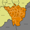 Bromley consists of 22 wards
made up of 60 council seats. These are currently represented by:
Since the Borough’s creation, Bromley had always been under Conservative control until the local elections of 7 May 1998 when a Liberal Democrat/Labour coalition assumed power. Following a number of by-election
s and a defection
, the Conservatives regained control on 5 July 2001.
The 22 wards are shown on the accompanying map. Ward names often straddle the named settlements and suburban areas above: their boundaries are fixed, whereas the latter are not.
increased. The population peaked in the 1970s, when industry began to relocate from London.
In the 2001 Census
, the borough had a population of 295,532 – of whom 141,785 were male, and 153,747 female. All major religions are represented, but of those stating a choice, 72.03% described themselves as Christian
, and 16.34% as having no religion
. Of the population, 43.47% were in full-time employment and 11.06% in part-time employment – compared to a London average of 42.64% and 8.62%, respectively. Residents were predominantly owner-occupiers, with 32.53% owning their house outright, and a further 42.73% owning with a mortgage. Only 1.42% were in local authority housing
, with a further 12.74% renting from a housing association
, or other registered social landlord.
previously had an office in Bromley
, London Borough of Bromley. In 2007 the company announced that it was moving the office to London Gatwick Airport
in Crawley
, West Sussex
.
station within its boundaries. However, the borough is home to many railway stations and, since May 2010, stations have been opened on the London Overground
network. The borough also has several stops on the London Tramlink
network.
National Rail stations:
Tramlink stops:
Crime Rates in Bromley (per 1000 population)>
Offence
Locally
Nationally
Robbery
3.01
1.85
Theft of a motor vehicle
5.20
4.04
Theft from a motor vehicle
10.99
9.59
Sexual offences
0.98
1.17
Violence against a person
18.38
19.97
Burglary
7.06
5.67
In 2006/2007 just under four thousand incidents were attended to in the borough. Noticeably, compared to 2005/2006 there was an 11% decrease in special service calls (road traffic collisions, chemical incidents, flooding etc.).
London Fire Brigade - Bromley Profile
London borough
The administrative area of Greater London contains thirty-two London boroughs. Inner London comprises twelve of these boroughs plus the City of London. Outer London comprises the twenty remaining boroughs of Greater London.-Functions:...
of south east London
London
London is the capital city of :England and the :United Kingdom, the largest metropolitan area in the United Kingdom, and the largest urban zone in the European Union by most measures. Located on the River Thames, London has been a major settlement for two millennia, its history going back to its...
, England and forms part of Outer London
Outer London
Outer London is the name for the group of London Boroughs that form a ring around Inner London.These were areas that were not part of the County of London and became formally part of Greater London in 1965...
. The principal town in the borough is Bromley
Bromley
Bromley is a large suburban town in south east London, England and the administrative headquarters of the London Borough of Bromley. It was historically a market town, and prior to 1963 was in the county of Kent and formed the administrative centre of the Municipal Borough of Bromley...
.
Geography
The borough is the largest in London by area and occupies 59 square miles (152.8 km²), of which the majority is Metropolitan Green BeltMetropolitan Green Belt
The Metropolitan Green Belt is a statutory green belt around London, England. It includes designated parts of Greater London and the surrounding counties of Bedfordshire, Berkshire, Buckinghamshire, Essex, Hertfordshire, Kent and Surrey in the South East and East of England regions.-History:The...
land. It is also perhaps the most rural.
Most of the settlement is in the north and west of the borough, with an outlier at Biggin Hill
Biggin Hill
Biggin Hill is an area and electoral ward in the outskirts of the London Borough of Bromley in southeast London, United Kingdom.-History:Historically the settlement was known as Aperfield and formed part of the parish of Cudham...
in the far south. The borough shares borders with Lewisham
London Borough of Lewisham
The London Borough of Lewisham is a London borough in south-east London, England and forms part of Inner London. The principal settlement of the borough is Lewisham...
, Greenwich
London Borough of Greenwich
The London Borough of Greenwich is an Inner London borough in south-east London, England. Taking its name from the historic town of Greenwich, the present borough was formed in 1965 by the amalgamation of the former area of the Metropolitan Borough of Greenwich with part of the Metropolitan...
and Bexley
London Borough of Bexley
The London Borough of Bexley lies in south east Greater London, and is a borough referred to as part of Outer London. It has common borders with the London Borough of Bromley to the south, the London Borough of Greenwich to the west, across the River Thames to the north it borders the London...
to the north, Southwark
London Borough of Southwark
The London Borough of Southwark is a London borough in south east London, England. It is directly south of the River Thames and the City of London, and forms part of Inner London.-History:...
and Lambeth
London Borough of Lambeth
The London Borough of Lambeth is a London borough in south London, England and forms part of Inner London. The local authority is Lambeth London Borough Council.-Origins:...
to the north west, Croydon
London Borough of Croydon
The London Borough of Croydon is a London borough in South London, England and is part of Outer London. It covers an area of and is the largest London borough by population. It is the southernmost borough of London. At its centre is the historic town of Croydon from which the borough takes its name...
to the west; and the counties of Surrey
Surrey
Surrey is a county in the South East of England and is one of the Home Counties. The county borders Greater London, Kent, East Sussex, West Sussex, Hampshire and Berkshire. The historic county town is Guildford. Surrey County Council sits at Kingston upon Thames, although this has been part of...
to the south and Kent
Kent
Kent is a county in southeast England, and is one of the home counties. It borders East Sussex, Surrey and Greater London and has a defined boundary with Essex in the middle of the Thames Estuary. The ceremonial county boundaries of Kent include the shire county of Kent and the unitary borough of...
to the south and east.
Westerham Heights, the highest point in London at an altitude of 245 metres, is located on the southern boundary. The Prime Meridian
Prime Meridian
The Prime Meridian is the meridian at which the longitude is defined to be 0°.The Prime Meridian and its opposite the 180th meridian , which the International Date Line generally follows, form a great circle that divides the Earth into the Eastern and Western Hemispheres.An international...
passes through Bromley.
History
The borough was formed, as were all other London boroughs, on 1 April 1965 by the London Government Act 1963London Government Act 1963
The London Government Act 1963 is an Act of the Parliament of the United Kingdom, which recognised officially the conurbation known as Greater London and created a new local government structure for the capital. The Act significantly reduced the number of local government districts in the area,...
. It comprised the former area of the Municipal Borough of Bromley
Municipal Borough of Bromley
Bromley was a local government district in northwest Kent from 1867 to 1965 around the town of Bromley. The area was suburban to London, and formed part of the Metropolitan Police District and from 1933 was included in the area of the London Passenger Transport Board.-Local board and urban...
, the Municipal Borough of Beckenham
Municipal Borough of Beckenham
Beckenham was a local government district in north west Kent from 1878 to 1965 around the town of Beckenham. The area was suburban to London, formed part of the Metropolitan Police District and from 1933 was included in the area of the London Passenger Transport Board.-History:In 1878 the parish of...
, Penge Urban District
Penge Urban District
Penge was a civil parish and a local government district located to the southeast of London, England. It included the settlements of Penge, Anerley and part of Crystal Palace...
, Orpington Urban District
Orpington Urban District
Orpington was a local government district in north west Kent from 1934 to 1965 around the town of Orpington, England.It was created an urban district in 1934 from parts of the abolished districts of Bromley Rural District and Chislehurst Urban District, taking in the entirety of Chelsfield, Cudham,...
and the Chislehurst
Chislehurst
Chislehurst is a suburban district in south-east London, England, and an electoral ward of the London Borough of Bromley. It is south-east of Charing Cross.-Toponymy:...
part of Chislehurst and Sidcup Urban District
Chislehurst and Sidcup Urban District
Chislehurst and Sidcup Urban District was a local government district and civil parish in north west Kent, England from 1934 to 1965.It was formed in 1934 from the former area of Chislehurst Urban District, Sidcup Urban District and part of Bromley Rural District.In 1965 the parish and urban...
, which was transferred from Kent
Kent
Kent is a county in southeast England, and is one of the home counties. It borders East Sussex, Surrey and Greater London and has a defined boundary with Essex in the middle of the Thames Estuary. The ceremonial county boundaries of Kent include the shire county of Kent and the unitary borough of...
to Greater London
Greater London
Greater London is the top-level administrative division of England covering London. It was created in 1965 and spans the City of London, including Middle Temple and Inner Temple, and the 32 London boroughs. This territory is coterminate with the London Government Office Region and the London...
.
In 1969, after a local campaign, the village of Knockholt
Knockholt
Knockholt is a village and civil parish in Kent, England, lying approximately 5 miles south of Orpington and 3 miles northwest of Sevenoaks. It is part of the Sevenoaks district and according to the 2001 census it had a population of 1,166...
was transferred back to Kent to become part of the Sevenoaks Rural District
Sevenoaks Rural District
Sevenoaks Rural District was a rural district in the county of Kent, England, from 1894 to 1974. It did not include Sevenoaks Urban District, which covered the town of Sevenoaks.It included the following civil parishes:*Brasted*Chevening*Chiddingstone...
and later Sevenoaks District
Sevenoaks (district)
Sevenoaks is a local government district covering the western most part of Kent in England. Its council is based in the town of Sevenoaks. It was formed on 1 April 1974, under the Local Government Act 1972, by a merger of the Sevenoaks Urban District, Sevenoaks Rural District and part of Dartford...
. Before 1965 it had been part of the Orpington Urban District.
Districts
As one of the outer London Boroughs it can be shown to be in two parts: urban and rural, the former to the north and very much part of the built-up area which is suburban London.The principal parts of the northern section, from west to east, are Beckenham
Beckenham
Beckenham is a town in the London Borough of Bromley, England. It is located 8.4 miles south east of Charing Cross and 1.75 miles west of Bromley town...
, which includes Eden Park and Elmers End
Elmers End
Elmers End is a place in London Borough of Bromley, England. It has a large green space which is the centre of a gyratory. Very close to the combined railway station and Tramlink terminus bearing its name is the old sewage farm. The remains of this industrial site can still be seen...
; Bromley
Bromley
Bromley is a large suburban town in south east London, England and the administrative headquarters of the London Borough of Bromley. It was historically a market town, and prior to 1963 was in the county of Kent and formed the administrative centre of the Municipal Borough of Bromley...
with Bickley
Bickley
Bickley is an affluent residential area and electoral ward in the London Borough of Bromley, England. It is a suburban development situated 10.4 miles south east of Charing Cross...
, Bromley Park and Bromley Common
Bromley Common
Bromley Common is the area centered around the road of the same name, stretching between Masons Hill at the south end of Bromley and Hastings Road, Locksbottom. Part of the A21...
, Park Langley, Plaistow, Shortlands
Shortlands
Shortlands is a ward of the London Borough of Bromley, located less than a mile from Bromley town centre. Historically, Shortlands was known as Clay Hill. It became known as Shortlands around 1800, after the fields which, at this point of the Ravensbourne river, ran at right angles up the slopes...
, and Southborough; Chislehurst
Chislehurst
Chislehurst is a suburban district in south-east London, England, and an electoral ward of the London Borough of Bromley. It is south-east of Charing Cross.-Toponymy:...
, with Elmstead
Elmstead
Elmstead is a residential district in the London Borough of Bromley lying between Chislehurst, Mottingham, Bromley and Bickley.Elmstead Woods, an ancient woodland, has public access from Elmstead Lane...
and Sundridge. The built-up area around Orpington
Orpington
Orpington is a suburban town and electoral ward in the London Borough of Bromley. It forms the southeastern edge of London's urban sprawl and is identified in the London Plan as one of 35 major centres in Greater London.-History:...
not only encompasses its direct outskirts of Chelsfield
Chelsfield
Chelsfield is a place in the London Borough of Bromley in London, England.The name is recorded in the Domesday Book of 1086 as Cillesfelle, meaning land of a man called Cēol....
, Crofton, Derry Downs, Goddington
Goddington
Goddington is an area of Orpington in the London Borough of Bromley.Goddington Park, 64 hectares of grass and trees, has five football pitches, two cricket squares, and two rugby pitches. It includes an astro-turf football court and about 10 tennis courts...
, Kevingtown, and Petts Wood
Petts Wood
-History:The name appeared first in 1577 as "the wood of the Pett family", who were shipbuilders and leased the wood as a source of timbers. William Willett, a campaigner for daylight saving time, lived in nearby Chislehurst for most of his life, and is commemorated by a memorial sundial in the...
; it also includes the erstwhile separate settlements of Farnborough
Farnborough, London
Farnborough is a settlement in the London Borough of Bromley. It is a suburban development located 13.4 miles southeast of Charing Cross.-History:...
, Green Street Green
Green Street Green
Green Street Green is a locality in the London Borough of Bromley at . It forms part of the Orpington post town. The nearest railway station is Chelsfield railway station, to the north east. The name originates from La Grenestrete c.1290, meaning the green or grassy hamlet...
, Pratts Bottom, St Mary Cray
St Mary Cray
St Mary Cray lies on the River Cray and is part of the London Borough of Bromley. St Mary Cray, like St Paul's Cray, has been somewhat overshadowed by the growth of nearby Orpington, which now provides local communities with their main shopping and business facilities...
and St Paul's Cray
St Paul's Cray
St Paul's Cray lies on the River Cray and is part of the London Borough of Bromley. St Paul's Cray was once a separate village, but like its sister St Mary Cray has been incorporated in to Orpington...
. Other smaller suburban areas include Anerley
Anerley
Anerley is a district of South London, England, located in the London Borough of Bromley. It is situated south south-east of Charing Cross. Anerley is geographically an outer lying area of London, although it is considered to have characteristics of an Inner city suburb...
and nearby Crystal Palace
Crystal Palace, London
Crystal Palace is a residential area in south London, England named from the former local landmark, The Crystal Palace, which occupied the area from 1854 to 1936. The area is located approximately 8 miles south east of Charing Cross, and offers impressive views over the capital...
; and Penge
Penge
Penge is a suburb of London in the London Borough of Bromley. It is located south east of Charing Cross.-History:Penge was once a small town, which was recorded under the name Penceat in a Saxon deed dating from 957...
. In addition, parts of Mottingham
Mottingham
Mottingham is a district of south London, England; located at the convergence of the London Borough of Bromley, the London Borough of Lewisham and the London Borough of Greenwich...
, Ruxley
Ruxley
Ruxley is a small settlement mostly within the London Borough of Bromley and on the boundary with the London Borough of Bexley, in southeast London, England....
and Swanley
Swanley
Swanley is a town and civil parish in the Sevenoaks District of Kent, England. It is located on the south-eastern outskirts of London, north of Sevenoaks town. The town boundaries encompass the settlements of Swanley itself, Hextable and Swanley Village...
lie within the borough boundaries.
There are two main areas in the southern part of the borough: Hayes
Hayes, Bromley
Hayes is a place in the London Borough of Bromley, south-east London, England. It has two main areas of activity: the ancient village and suburban Hayes.-The ancient village of Nimrods :...
and West Wickham
West Wickham
West Wickham is a place in the London Borough of Bromley, England. It is 10.3 miles south east of Charing Cross. West Wickham history dates back to early settlements existing since 1068, although the name `Wickham` is an indication of an earlier Anglo-Saxon settlement...
. Biggin Hill
Biggin Hill
Biggin Hill is an area and electoral ward in the outskirts of the London Borough of Bromley in southeast London, United Kingdom.-History:Historically the settlement was known as Aperfield and formed part of the parish of Cudham...
, Downe
Downe
Downe is a village in the London Borough of Bromley in London, UK.Downe is south west of Orpington and south east of Charing Cross. Downe lies in a wooded valley, and much of the centre of the village is unchanged; the former village school now acts as the village hall.-Darwin:Charles Darwin...
and Keston
Keston
Keston is a part suburban, part rural area of the London Borough of Bromley, England. It lies on the edge of Hayes Common, to the northwest of Greater London's border with Kent.-History:...
with Leaves Green
Leaves Green
Leaves Green is a village in the London Borough of Bromley in London, UK.The village lies on the Bromley to Westerham road , adjacent to the north-western perimeter of Biggin Hill Airport. It is some south of Bromley and north of Biggin Hill....
and Nash are separate, smaller, rural settlements.
Local attractions include Down House
Down House
Down House is the former home of the English naturalist Charles Darwin and his family. It was in this house and garden that Darwin worked on his theories of evolution by natural selection which he had conceived in London before moving to Downe....
(the home of Charles Darwin
Charles Darwin
Charles Robert Darwin FRS was an English naturalist. He established that all species of life have descended over time from common ancestry, and proposed the scientific theory that this branching pattern of evolution resulted from a process that he called natural selection.He published his theory...
), Chislehurst Caves
Chislehurst Caves
Chislehurst Caves are a long series of tunnels in Chislehurst, in the south eastern suburbs of Greater London. Although called caves, they are chalk and flint mines and entirely man-made....
, Holwood House
Holwood House
Holwood House is a country house in Keston, near Hayes, in the London Borough of Bromley, England. The house was designed by Decimus Burton, built between 1823 and 1826 and is in the Greek Revival style. It was built for John Ward who later employed Burton to lay out his Calverley Park Estate in...
(the home of William Pitt the Younger
William Pitt the Younger
William Pitt the Younger was a British politician of the late 18th and early 19th centuries. He became the youngest Prime Minister in 1783 at the age of 24 . He left office in 1801, but was Prime Minister again from 1804 until his death in 1806...
), Crofton Roman Villa
Crofton Roman Villa
Crofton Roman Villa in Orpington, in the London Borough of Bromley, is a Roman villa which was inhabited between approximately 140 and 400 AD. It was the centre of a farming estate of about 500 acres , with farm buildings nearby, surrounded by fields, meadows and woods...
, and the site of The Crystal Palace
The Crystal Palace
The Crystal Palace was a cast-iron and glass building originally erected in Hyde Park, London, England, to house the Great Exhibition of 1851. More than 14,000 exhibitors from around the world gathered in the Palace's of exhibition space to display examples of the latest technology developed in...
.
Governance
Wards of the United Kingdom
A ward in the United Kingdom is an electoral district at sub-national level represented by one or more councillors. It is the primary unit of British administrative and electoral geography .-England:...
made up of 60 council seats. These are currently represented by:
- ConservativeConservative Party (UK)The Conservative Party, formally the Conservative and Unionist Party, is a centre-right political party in the United Kingdom that adheres to the philosophies of conservatism and British unionism. It is the largest political party in the UK, and is currently the largest single party in the House...
: 53 - Liberal DemocratLiberal DemocratsThe Liberal Democrats are a social liberal political party in the United Kingdom which supports constitutional and electoral reform, progressive taxation, wealth taxation, human rights laws, cultural liberalism, banking reform and civil liberties .The party was formed in 1988 by a merger of the...
: 4 - LabourLabour Party (UK)The Labour Party is a centre-left democratic socialist party in the United Kingdom. It surpassed the Liberal Party in general elections during the early 1920s, forming minority governments under Ramsay MacDonald in 1924 and 1929-1931. The party was in a wartime coalition from 1940 to 1945, after...
councillors: 3
Since the Borough’s creation, Bromley had always been under Conservative control until the local elections of 7 May 1998 when a Liberal Democrat/Labour coalition assumed power. Following a number of by-election
By-election
A by-election is an election held to fill a political office that has become vacant between regularly scheduled elections....
s and a defection
Defection
In politics, a defector is a person who gives up allegiance to one state or political entity in exchange for allegiance to another. More broadly, it involves abandoning a person, cause or doctrine to whom or to which one is bound by some tie, as of allegiance or duty.This term is also applied,...
, the Conservatives regained control on 5 July 2001.
The 22 wards are shown on the accompanying map. Ward names often straddle the named settlements and suburban areas above: their boundaries are fixed, whereas the latter are not.
Demographics
In 1801, the civil parishes that form the modern borough had a total population of 8,944. This rose slowly throughout the 19th century, as the district became built up; reaching 17,192 in the middle of the century. When the railways arrived the rate of population growthPopulation growth
Population growth is the change in a population over time, and can be quantified as the change in the number of individuals of any species in a population using "per unit time" for measurement....
increased. The population peaked in the 1970s, when industry began to relocate from London.
In the 2001 Census
United Kingdom Census 2001
A nationwide census, known as Census 2001, was conducted in the United Kingdom on Sunday, 29 April 2001. This was the 20th UK Census and recorded a resident population of 58,789,194....
, the borough had a population of 295,532 – of whom 141,785 were male, and 153,747 female. All major religions are represented, but of those stating a choice, 72.03% described themselves as Christian
Christian
A Christian is a person who adheres to Christianity, an Abrahamic, monotheistic religion based on the life and teachings of Jesus of Nazareth as recorded in the Canonical gospels and the letters of the New Testament...
, and 16.34% as having no religion
Irreligion
Irreligion is defined as an absence of religion or an indifference towards religion. Sometimes it may also be defined more narrowly as hostility towards religion. When characterized as hostility to religion, it includes antitheism, anticlericalism and antireligion. When characterized as...
. Of the population, 43.47% were in full-time employment and 11.06% in part-time employment – compared to a London average of 42.64% and 8.62%, respectively. Residents were predominantly owner-occupiers, with 32.53% owning their house outright, and a further 42.73% owning with a mortgage. Only 1.42% were in local authority housing
Public housing
Public housing is a form of housing tenure in which the property is owned by a government authority, which may be central or local. Social housing is an umbrella term referring to rental housing which may be owned and managed by the state, by non-profit organizations, or by a combination of the...
, with a further 12.74% renting from a housing association
Housing association
Housing associations in the United Kingdom are independent not-for-profit bodies that provide low-cost "social housing" for people in housing need. Any trading surplus is used to maintain existing homes and to help finance new ones...
, or other registered social landlord.
Economy
BDO InternationalBDO International
BDO International is a worldwide professional services network of public accountancy firms, serving national and international clients. Each BDO Member Firm is an independent legal entity in its own country. The network, originally formed in 1963 as Binder Seidman International Group, is...
previously had an office in Bromley
Bromley
Bromley is a large suburban town in south east London, England and the administrative headquarters of the London Borough of Bromley. It was historically a market town, and prior to 1963 was in the county of Kent and formed the administrative centre of the Municipal Borough of Bromley...
, London Borough of Bromley. In 2007 the company announced that it was moving the office to London Gatwick Airport
London Gatwick Airport
Gatwick Airport is located 3.1 miles north of the centre of Crawley, West Sussex, and south of Central London. Previously known as London Gatwick,In 2010, the name changed from London Gatwick Airport to Gatwick Airport...
in Crawley
Crawley
Crawley is a town and local government district with Borough status in West Sussex, England. It is south of Charing Cross, north of Brighton and Hove, and northeast of the county town of Chichester, covers an area of and had a population of 99,744 at the time of the 2001 Census.The area has...
, West Sussex
West Sussex
West Sussex is a county in the south of England, bordering onto East Sussex , Hampshire and Surrey. The county of Sussex has been divided into East and West since the 12th century, and obtained separate county councils in 1888, but it remained a single ceremonial county until 1974 and the coming...
.
Transport
Bromley is one of only six London Boroughs not to have at least one London UndergroundLondon Underground
The London Underground is a rapid transit system serving a large part of Greater London and some parts of Buckinghamshire, Hertfordshire and Essex in England...
station within its boundaries. However, the borough is home to many railway stations and, since May 2010, stations have been opened on the London Overground
London Overground
London Overground is a suburban rail network in London and Hertfordshire. It has been operated by London Overground Rail Operations since 2007 as part of the National Rail network, under the franchise control and branding of Transport for London...
network. The borough also has several stops on the London Tramlink
London Tramlink
London Tramlink is an arm of Transport for London, which manages the second generation of tram services within London, UK. Current and planned tram systems are:*Tramlink operates a three-route system in the area of South London around Croydon...
network.
National Rail stations:
- Crystal PalaceCrystal Palace railway stationCrystal Palace railway station is in the London Borough of Bromley in south London. It is located in the Anerley area between the town centres of Crystal Palace and Penge...
(Also on the London Overground) - BirkbeckBirkbeck stationBirkbeck station is a railway station and light rail stop in the London Borough of Bromley in the southern suburbs of London. It is located on Elmers End Road and alongside Beckenham Crematorium.- Network rail :...
- Beckenham Junction
- ShortlandsShortlands railway stationShortlands railway station is in Shortlands, in the London Borough of Bromley in south London. It serves the southwest part of Bromley, and is 10 miles from London Victoria....
- Bromley NorthBromley North railway stationBromley North railway station is in the London Borough of Bromley in south-east London, in Travelcard Zone 4. The station and all trains serving it are operated by Southeastern. It is the terminus of the short Bromley North Branch Line from Grove Park....
- Bromley SouthBromley South railway stationBromley South railway station is a major interchange and station in Bromley town centre within the London Borough of Bromley in southeast London. It is in Travelcard Zone 5, and the station and all trains are operated by Southeastern...
- St Mary CraySt Mary Cray railway stationSt Mary Cray railway station is in the London Borough of Bromley in south-east London, in Travelcard Zone 6. The station is operated by Southeastern, as are all trains serving it.The station is 14.7 miles from London Victoria...
- Sundridge ParkSundridge Park railway stationSundridge Park railway station is in the London Borough of Bromley in south-east London, in Travelcard Zone 4. The station, and all trains serving it, is operated by Southeastern.-Location:...
- RavensbourneRavensbourne railway stationRavensbourne railway station is in the London Borough of Bromley in south London. It is in Travelcard Zone 4, and the station and all trains are operated by Southeastern....
- BickleyBickley railway stationBickley railway station is in the London Borough of Bromley in south London. It lies between Bromley South and Swanley stations. The station and all trains are operated by Southeastern, and is in Travelcard Zone 5....
- Elmstead WoodsElmstead Woods railway stationElmstead Woods railway station is in Elmstead in the London Borough of Bromley in south east London. It is in Travelcard Zone 4, and the station and all trains are operated by Southeastern.- Services :The typical off-peak service is...
- ChislehurstChislehurst railway stationChislehurst railway station is in the London Borough of Bromley in south London. It is in Travelcard Zone 5, and the station and all trains are operated by Southeastern....
- Petts WoodPetts Wood railway stationPetts Wood railway station serves Petts Wood in the London Borough of Bromley, and is in Travelcard Zone 5. The station was built on the main line to the north of Orpington and opened on 9 July 1928, and the community now surrounding it developed from that date: now the railway divides Petts Wood...
- OrpingtonOrpington railway stationOrpington railway station serves the town of Orpington in the London Borough of Bromley, and is in Travelcard Zone 6. Located in Crofton Road, the station is a 500m west of the southern end of Orpington High Street....
- ChelsfieldChelsfield railway stationChelsfield railway station is in the London Borough of Bromley, and serves the southern parts of the built-up area of Orpington - Chelsfield itself, and Green Street Green. It is in Travelcard Zone 6....
- KnockholtKnockholt railway stationKnockholt railway station is a railway station in the south eastern corner of the London Borough of Bromley, in Travelcard Zone 6 and on the South Eastern Main Line. It is located next to the Greater London boundary with Kent district of Sevenoaks...
- Kent HouseKent House railway stationKent House railway station serves an area between Penge and Beckenham in the London Borough of Bromley in south London: it takes its name from Kent House farm nearby, historically the first house in Kent after crossing the Surrey border. It is in Travelcard Zone 4, and the station and all trains...
- Penge EastPenge East railway stationPenge East railway station is in the London Borough of Bromley in south London. It is in Travelcard Zone 4, and the station and nearly all trains are operated by Southeastern...
- Penge WestPenge West railway stationPenge West railway station is in the London Borough of Bromley in south London. The station is operated by London Overground, with London Overground and Southern trains serving the station. First Capital Connect and some Southern services pass through the station. It is located in Travelcard Zone...
(Also on the London Overground) - AnerleyAnerley railway stationAnerley railway station is in the London Borough of Bromley in south London. The station is operated by London Overground, with London Overground and Southern trains serving the station. It is located in Travelcard Zone 4....
(Also on the London Overground) - Lower SydenhamLower Sydenham railway stationLower Sydenham railway station is just to the north of the boundary between the London Borough of Lewisham and the London Borough of Bromley in south east London, in Travelcard Zone 4...
(Shared with LewishamLondon Borough of LewishamThe London Borough of Lewisham is a London borough in south-east London, England and forms part of Inner London. The principal settlement of the borough is Lewisham...
) - New BeckenhamNew Beckenham railway stationNew Beckenham railway station serves Beckenham in the London Borough of Bromley in south east London, in Travelcard Zone 4. The station and all trains serving it are operated by Southeastern.- Services :The typical off peak train service per hour is:...
- Clock HouseClock House railway stationClock House railway station is in the London Borough of Bromley in south east London, in Travelcard Zone 4 between Beckenham and Penge. The station and all trains serving it are operated by Southeastern on the Hayes line....
- Elmers EndElmers End stationElmers End station is a railway station and tram terminus in Elmers End, South London, England. It is in the London Borough of Bromley, and Travelcard Zone 4 south of London Charing Cross....
- Eden ParkEden Park railway stationEden Park railway station serves Eden Park in the London Borough of Bromley in south east London, in Travelcard Zone 5. The station and all trains serving it is operated by Southeastern on the Hayes line...
- West WickhamWest Wickham railway stationWest Wickham railway station serves West Wickham in the London Borough of Bromley. It is located in south east London and is in Travelcard Zone 5. The station is operated by Southeastern and is served by Southeastern Hayes line trains.- History :...
- HayesHayes railway stationHayes railway station is a railway station located in Hayes in the London Borough of Bromley, south east London, England.The station is served by Southeastern services from Charing Cross and Cannon Street. It forms the suburban terminus for trains on the Hayes line...
Tramlink stops:
- Beckenham Junction
- Beckenham RoadBeckenham Road tram stopBeckenham Road tram stop is a light rail stop in the London Borough of Bromley in the southern suburbs of London. The stop is located on an embankment above Beckenham Road which connects Beckenham with Crystal Palace and Penge on the site of the short-lived West End of London & Crystal Palace...
- Avenue RoadAvenue Road tram stopAvenue Road tram stop is a light rail stop in the London Borough of Bromley in the southern suburbs of London. It is located on Avenue Road in a mainly residential area between Penge and Beckenham....
- BirkbeckBirkbeck stationBirkbeck station is a railway station and light rail stop in the London Borough of Bromley in the southern suburbs of London. It is located on Elmers End Road and alongside Beckenham Crematorium.- Network rail :...
- Elmers EndElmers End stationElmers End station is a railway station and tram terminus in Elmers End, South London, England. It is in the London Borough of Bromley, and Travelcard Zone 4 south of London Charing Cross....
Crime
Crime rates in Bromley are generally higher than the National average, however it is considered one of the safest London boroughs.London Fire Brigade
London Fire Brigade has four fire stations within the London Borough of Bromley. The borough is the largest in the city; at approximately 150 kmsq. With just one pumping appliance, Orpington has one of the largest station grounds in London, measuring 46.7 kmsq. In 2006/2007, Orpington attended 1,308 incidents. There is also a high volume pump at the station. Beckenham, Bromley and Biggin Hill cover the rest of the borough with four pumping appliances and a hose layer.In 2006/2007 just under four thousand incidents were attended to in the borough. Noticeably, compared to 2005/2006 there was an 11% decrease in special service calls (road traffic collisions, chemical incidents, flooding etc.).
London Fire Brigade - Bromley Profile
External links
- Summary of formation of the Borough, including its constituent parts
- London Borough of Bromley council website
- London Borough of Bromley Museum
- Bromley mytime - local sports facilities
- Council for Voluntary Service for the London Borough of Bromley
- Directory of local community services
- Images of Bromley
- Bromley Neighbourhood Watch Association website (BromleyNWA.org.uk)