

Purissima, California
Encyclopedia
Purissima is a ghost town
in southwestern San Mateo County
, California
, United States
, near the junction of State Route 1
and Verde Road. Purisima means "purest" in Spanish, and is most commonly used in Spanish to refer to La Purísima Concepción (the Immaculate Conception
) of the Virgin Mary (note historical misspelling in English resulting in double "s").
 Located on José María Alviso
's Rancho Cañada de Verde y Arroyo de la Purisima
in a rural area four miles (6 km) south of Half Moon Bay
, the village was one of the earliest settlements on the San Mateo County coast, founded in an agricultural area in the early 1850s. The community was badly flooded by Purissima Creek in January 1862, the same month that much of northern California experienced its worst floods in history. Some fields and buildings were swept away.
Henry Dobbel (born in Holstein
, Germany
on July 1, 1829; died in Purissima on December 22, 1891) came to California via Cape Horn
in 1845. After working at odd jobs, and even running a San Francisco restaurant, Dobbel married fellow German Margaret Roverkamf-Schroeder (born near Hanover, Germany, in 1831; died in Purissima on September 3, 1885). She had come to California via the Isthmus of Panama
. They bought a farm in the East Bay. In the 1860s, they sold their farm and bought 1000 acres (4 km²) from John Purcell. They built a big, ornate house on the south bank of Purissima Creek. The house had two stories and 17 rooms; it boasted such innovations as gas lighting and running water. Dobbel employed 50 men who planted and harvested wheat, barley, and potatoes.
By the early 1870s, Purissima had a post office, several stores, a school, a one-story hotel known as Purissima House (owned by Richard Dougherty), and other buildings. The general store was built by Henry Husing. A lumber mill was constructed at the mouth of Purissima Canyon, to take advantage of the extensive redwood logging in the nearby Santa Cruz Mountains
.
Oil was discovered near the village in the 1880s on George Shout's land. However, hopes of an oil boom were dashed when only 20 barrels a day was produced. The U.S. Geological Survey has noted later efforts to drill for oil in the area, usually resulting in minor production.
Henry Dobbel bought the general store, only to encounter financial difficulties when he extended credit to many of his customers. Then there were a series of crop failures, which eventually impacted Dobbel and the entire community. Henry Dobbel went bankrupt and sold his estate in 1890 to Henry Cowell. He remained in the area, however, and both he and his wife are buried in the village cemetery.
The Ocean Shore Railroad
, which operated from San Francisco
to Tunitas Creek
from 1907 to 1920, included a stop at Purissima, as noted on a U.S. Geological Survey's Santa Cruz
quadrangle map.
The Purissima Post Office opened in 1868, only to be discontinued in 1869. Then, in 1872, it reopened and continued to serve the community until 1901.
Some buildings still remained as late as the 1930s, but the town was largely abandoned before World War II
. The 1940 U.S. Geological Survey map shows a few buildings and notes the "Purissima School." The 1943 map still shows the school. At that time, State Route 1
still passed directly through Purissima. Today, Highway 1 runs farther west of the original route. Verde Road runs north from Lobitos
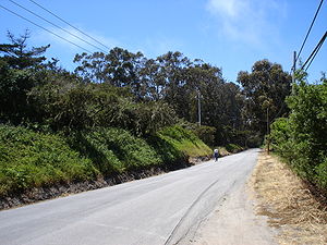
to Purissima Creek Road; this is actually the original alignment of Highway 1. According to the older maps, the school was located on the north side of what is now Verde Road, just east of Highway 1. The cemetery is in the woods bordered by Verde Road and Highway 1.
In 1939, the Federal Writers Project guidebook for California noted, "The village of Purisima, once a lively town on Jose Maria Alivso's Rancho Canada y Arroyo de la Purisima, is ghostly and deserted now. Its weathered gray buildings stand among mosshung cypresses and eucalytpus trees, their windows broken, their stairs falling in, their facades rudely stuck with gay circus posters."
No clear reasons have been found for the demise of the community; presumably its remote location led some residents to move to Half Moon Bay or other communities. All that remains of Purissima today is the cemetery (still noted on U.S. Geological Survey maps) and a part of the school. Several farms surround the site. There are numerous evergreen trees and heavy vegetation at the site. Dayna Chalif, who has explored the Purissima Cemetery and researched historic archives, wrote, "The town's prominent citizens died in the same amount of time...Purissima was supposed to be the big town on the coast, [but it] was harder to get to." The failure of the Ocean Shore Railroad, which was intended to provide better access to the San Mateo County coast, may have hurt Purissima, although the village was later included on the original routing of Highway 1.
Until the 1950s, however, much of the San Mateo County coastal area remained sparsely settled and the few surviving communities were relatively small. With the dramatic rise of housing costs along San Francisco Bay (with average prices over $1 million in 2008), there has been greater incentive to build along the Pacific Ocean, resulting in the steady growth of Montara
, Moss Beach
, El Granada
, Half Moon Bay
, and Pescadero
. This has done little for Purissima, which had long since vanished. Local newspaper articles have frequently mentioned that limited access to the area, primarily via Highways 1 and 92, has been a major factor in the slow growth. With the pending completion of the Devil's Slide tunnel on Highway 1 in 2012, access may improve in the near future.
to the east. There are some seasonal, sometimes spectacular falls along the creek. The creek was originally named "Arroyo de la Purissima" by Spanish explorers.
In the summer of 2005, Dayna Chalif transcribed the existing gravestones in the Purissima Cemetery, which is now largely overgrown with weeds, vines, and poison oak
. The cemetery is very difficult to access. Some of it can be seen from Verde Road. Today, many of the gravestones in this cemetery are missing, broken, or completely hidden by the overgrown plants.
Ghost town
A ghost town is an abandoned town or city. A town often becomes a ghost town because the economic activity that supported it has failed, or due to natural or human-caused disasters such as floods, government actions, uncontrolled lawlessness, war, or nuclear disasters...
in southwestern San Mateo County
San Mateo County, California
San Mateo County is a county located in the San Francisco Bay Area of the U.S. state of California. It covers most of the San Francisco Peninsula just south of San Francisco, and north of Santa Clara County. San Francisco International Airport is located at the northern end of the county, and...
, California
California
California is a state located on the West Coast of the United States. It is by far the most populous U.S. state, and the third-largest by land area...
, United States
United States
The United States of America is a federal constitutional republic comprising fifty states and a federal district...
, near the junction of State Route 1
California State Route 1
State Route 1 , more often called Highway 1, is a state highway that runs along much of the Pacific coast of the U.S. state of California. It is famous for running along some of the most beautiful coastlines in the world, leading to its designation as an All-American Road.Highway 1 does not run...
and Verde Road. Purisima means "purest" in Spanish, and is most commonly used in Spanish to refer to La Purísima Concepción (the Immaculate Conception
Immaculate Conception
The Immaculate Conception of Mary is a dogma of the Roman Catholic Church, according to which the Virgin Mary was conceived without any stain of original sin. It is one of the four dogmata in Roman Catholic Mariology...
) of the Virgin Mary (note historical misspelling in English resulting in double "s").
History
José María Alviso
José María de Jesus Alviso was an early settler of the Silicon Valley in California, alcalde of San José, and grantee of Rancho Milpitas. Alviso's house, the Jose Maria Alviso Adobe, is listed on National Register of Historic Places.-Biography:Alviso was born in 1798 and baptized at Mission Santa...
's Rancho Cañada de Verde y Arroyo de la Purisima
Rancho Cañada de Verde y Arroyo de la Purisima
Rancho Cañada de Verde y Arroyo de la Purisima was a Mexican land grant in present day San Mateo County, California given in 1838 by Governor Juan B. Alvarado to José María Alviso...
in a rural area four miles (6 km) south of Half Moon Bay
Half Moon Bay, California
Half Moon Bay is a coastal city in San Mateo County, California, USA. Its population was 11,324 as of the 2010 census. Immediately at the north of Half Moon Bay is the Pillar Point Harbor and the unincorporated community of Princeton-by-the-Sea....
, the village was one of the earliest settlements on the San Mateo County coast, founded in an agricultural area in the early 1850s. The community was badly flooded by Purissima Creek in January 1862, the same month that much of northern California experienced its worst floods in history. Some fields and buildings were swept away.
Henry Dobbel (born in Holstein
Holstein
Holstein is the region between the rivers Elbe and Eider. It is part of Schleswig-Holstein, the northernmost state of Germany....
, Germany
Germany
Germany , officially the Federal Republic of Germany , is a federal parliamentary republic in Europe. The country consists of 16 states while the capital and largest city is Berlin. Germany covers an area of 357,021 km2 and has a largely temperate seasonal climate...
on July 1, 1829; died in Purissima on December 22, 1891) came to California via Cape Horn
Cape Horn
Cape Horn is the southernmost headland of the Tierra del Fuego archipelago of southern Chile, and is located on the small Hornos Island...
in 1845. After working at odd jobs, and even running a San Francisco restaurant, Dobbel married fellow German Margaret Roverkamf-Schroeder (born near Hanover, Germany, in 1831; died in Purissima on September 3, 1885). She had come to California via the Isthmus of Panama
Isthmus of Panama
The Isthmus of Panama, also historically known as the Isthmus of Darien, is the narrow strip of land that lies between the Caribbean Sea and the Pacific Ocean, linking North and South America. It contains the country of Panama and the Panama Canal...
. They bought a farm in the East Bay. In the 1860s, they sold their farm and bought 1000 acres (4 km²) from John Purcell. They built a big, ornate house on the south bank of Purissima Creek. The house had two stories and 17 rooms; it boasted such innovations as gas lighting and running water. Dobbel employed 50 men who planted and harvested wheat, barley, and potatoes.
By the early 1870s, Purissima had a post office, several stores, a school, a one-story hotel known as Purissima House (owned by Richard Dougherty), and other buildings. The general store was built by Henry Husing. A lumber mill was constructed at the mouth of Purissima Canyon, to take advantage of the extensive redwood logging in the nearby Santa Cruz Mountains
Santa Cruz Mountains
The Santa Cruz Mountains, part of the Pacific Coast Ranges, are a mountain range in central California, United States. They form a ridge along the San Francisco Peninsula, south of San Francisco, separating the Pacific Ocean from San Francisco Bay and the Santa Clara Valley, and continuing south,...
.
Oil was discovered near the village in the 1880s on George Shout's land. However, hopes of an oil boom were dashed when only 20 barrels a day was produced. The U.S. Geological Survey has noted later efforts to drill for oil in the area, usually resulting in minor production.
Henry Dobbel bought the general store, only to encounter financial difficulties when he extended credit to many of his customers. Then there were a series of crop failures, which eventually impacted Dobbel and the entire community. Henry Dobbel went bankrupt and sold his estate in 1890 to Henry Cowell. He remained in the area, however, and both he and his wife are buried in the village cemetery.
The Ocean Shore Railroad
Ocean Shore Railroad
The Ocean Shore Railroad was intended to be built from San Francisco to Santa Cruz, California, via a route along the Pacific coastline.-History:...
, which operated from San Francisco
San Francisco, California
San Francisco , officially the City and County of San Francisco, is the financial, cultural, and transportation center of the San Francisco Bay Area, a region of 7.15 million people which includes San Jose and Oakland...
to Tunitas Creek
Tunitas Creek
Tunitas Creek is a stream in San Mateo County, California. Tunitas is Spanish for "Little Prickly Pears". Historically the creek was also known as Arroyo de Las Tunitas....
from 1907 to 1920, included a stop at Purissima, as noted on a U.S. Geological Survey's Santa Cruz
Santa Cruz, California
Santa Cruz is the county seat and largest city of Santa Cruz County, California in the US. As of the 2010 U.S. Census, Santa Cruz had a total population of 59,946...
quadrangle map.
The Purissima Post Office opened in 1868, only to be discontinued in 1869. Then, in 1872, it reopened and continued to serve the community until 1901.
Some buildings still remained as late as the 1930s, but the town was largely abandoned before World War II
World War II
World War II, or the Second World War , was a global conflict lasting from 1939 to 1945, involving most of the world's nations—including all of the great powers—eventually forming two opposing military alliances: the Allies and the Axis...
. The 1940 U.S. Geological Survey map shows a few buildings and notes the "Purissima School." The 1943 map still shows the school. At that time, State Route 1
California State Route 1
State Route 1 , more often called Highway 1, is a state highway that runs along much of the Pacific coast of the U.S. state of California. It is famous for running along some of the most beautiful coastlines in the world, leading to its designation as an All-American Road.Highway 1 does not run...
still passed directly through Purissima. Today, Highway 1 runs farther west of the original route. Verde Road runs north from Lobitos
Lobitos, California
Lobitos, California is a populated place in San Mateo County, just east of State Route 1 and south of Half Moon Bay and the ghost town of Purissima. Its location is latitude 372259N, longitude 1222357W; decimal degrees: latitude 37.38306, longitude -122.39917...
to Purissima Creek Road; this is actually the original alignment of Highway 1. According to the older maps, the school was located on the north side of what is now Verde Road, just east of Highway 1. The cemetery is in the woods bordered by Verde Road and Highway 1.
In 1939, the Federal Writers Project guidebook for California noted, "The village of Purisima, once a lively town on Jose Maria Alivso's Rancho Canada y Arroyo de la Purisima, is ghostly and deserted now. Its weathered gray buildings stand among mosshung cypresses and eucalytpus trees, their windows broken, their stairs falling in, their facades rudely stuck with gay circus posters."
No clear reasons have been found for the demise of the community; presumably its remote location led some residents to move to Half Moon Bay or other communities. All that remains of Purissima today is the cemetery (still noted on U.S. Geological Survey maps) and a part of the school. Several farms surround the site. There are numerous evergreen trees and heavy vegetation at the site. Dayna Chalif, who has explored the Purissima Cemetery and researched historic archives, wrote, "The town's prominent citizens died in the same amount of time...Purissima was supposed to be the big town on the coast, [but it] was harder to get to." The failure of the Ocean Shore Railroad, which was intended to provide better access to the San Mateo County coast, may have hurt Purissima, although the village was later included on the original routing of Highway 1.
Until the 1950s, however, much of the San Mateo County coastal area remained sparsely settled and the few surviving communities were relatively small. With the dramatic rise of housing costs along San Francisco Bay (with average prices over $1 million in 2008), there has been greater incentive to build along the Pacific Ocean, resulting in the steady growth of Montara
Montara, California
Montara is a census-designated place in San Mateo County, California, United States. The population was 2,909 at the 2010 census. Nearby communities include Moss Beach and Princeton-by-the-Sea.-Geography and environment:...
, Moss Beach
Moss Beach, California
Moss Beach is a coastal census-designated place in San Mateo County, California, with a year 2010 census population of 3,103. Located in Moss Beach are the Fitzgerald Marine Reserve, a marine sanctuary; the Half Moon Bay Airport, the historic Moss Beach Distillery and the Seal Cove Inn, a...
, El Granada
El Granada, California
El Granada is a census-designated place in the coastal area of northern San Mateo County, California, United States. The population was 5,467 at the 2010 census.-Geography:...
, Half Moon Bay
Half Moon Bay, California
Half Moon Bay is a coastal city in San Mateo County, California, USA. Its population was 11,324 as of the 2010 census. Immediately at the north of Half Moon Bay is the Pillar Point Harbor and the unincorporated community of Princeton-by-the-Sea....
, and Pescadero
Pescadero, California
Pescadero is a census-designated place in San Mateo County, California two miles east of State Route 1 and Pescadero State Beach. The center of town, on Pescadero Creek Road, is located at latitude 37.255 and longitude 122.38028. The town is south of Half Moon Bay. The ZIP Code is 94060 and...
. This has done little for Purissima, which had long since vanished. Local newspaper articles have frequently mentioned that limited access to the area, primarily via Highways 1 and 92, has been a major factor in the slow growth. With the pending completion of the Devil's Slide tunnel on Highway 1 in 2012, access may improve in the near future.
Purissima Creek
There is also the same named Purissima Creek, which passes near the town site. Purissima Creek Road follows the creek for some distance, toward the Santa Cruz MountainsSanta Cruz Mountains
The Santa Cruz Mountains, part of the Pacific Coast Ranges, are a mountain range in central California, United States. They form a ridge along the San Francisco Peninsula, south of San Francisco, separating the Pacific Ocean from San Francisco Bay and the Santa Clara Valley, and continuing south,...
to the east. There are some seasonal, sometimes spectacular falls along the creek. The creek was originally named "Arroyo de la Purissima" by Spanish explorers.
Cemetery
On September 15, 1868, John Purcell deeded some of his property to the citizens of Purissima for a burial ground. The Purissima Cemetery Association was created. Free burials were to be provided to Purissima residents. A Protestant church was to be built next to the cemetery.In the summer of 2005, Dayna Chalif transcribed the existing gravestones in the Purissima Cemetery, which is now largely overgrown with weeds, vines, and poison oak
Poison oak
Poison oak may refer to* Toxicodendron diversilobum, grows on West Coast of North America* Toxicodendron pubescens, grows in the Eastern United Statesdamnnnnn tissss is terribleee...
. The cemetery is very difficult to access. Some of it can be seen from Verde Road. Today, many of the gravestones in this cemetery are missing, broken, or completely hidden by the overgrown plants.