

Montara, California
Encyclopedia
Montara is a census-designated place
(CDP) in San Mateo County
, California
, United States
. The population was 2,909 at the 2010 census. Nearby communities include Moss Beach and Princeton-by-the-Sea.
and 50 miles (80.5 km) north of Santa Cruz, California
. Neighboring towns include Pacifica
to the north, Moss Beach
, El Granada
, and Half Moon Bay
to the south. According to the United States Census Bureau
, the CDP has a total area of 3.9 square miles (10.1 km²), all of it land.
The rare
and endangered species
Hickman's potentilla
occurs at the northern extremity of Montara on the slopes above Martini Creek
at elevations ranging from 32 to 410 feet (10 to 125 meters).
Nearby Montara Mountain
, part of the Santa Cruz Mountains
, rises to an elevation of 1,898 feet (578 m) above sea level. The mountain is accessible by a gravel fire road. On a few occasions light snowfall has fallen on the upper reaches of the mountain; this happened in February 2011 and was documented in videos and photographs on Youtube
and Google
.
The town is surrounded by open space (Rancho Corral del Tierra) and a popular recreation area includes Montara State Beach
. The nearly mile long stretch of sand drops steeply into the ocean making it hazardous for swimming. It is, however, a fairly popular surfing destination for experienced surfers. 10-15+ ft. waves can be common during winter storm swells.
, heavy fogs and low overcasts are common throughout the year, sometimes producing light drizzle. Stray showers sometimes occur during the summer months, which are mostly dry. January, the coldest month, normally has high temperatures in the upper fifties (~14°C) and low temperatures in the middle forties (~8°C). Freezing temperatures are extremely rare, especially near the ocean. September, the warmest month, normally has high temperatures in the upper sixties (~20°C) and lows in the lower fifties (~11°C). Temperatures rarely exceed 90°F (32°C) and whenever there are daytime temperatures above 80°F (27°C) it still cools to the fifties (~13°C) at night. During experimental observations by a U.S. Geological Survey volunteer (from 1985 to 1989), the highest temperature was an amazing 100°F (38°C) and the lowest was 31°F (-0.5°C). The nearest official National Weather Service
station is at Half Moon Bay
. Recently, an automated weather station was set up in Montara, providing regular observations on the National Weather Service's website, weather.gov.
was 750.1 people per square mile (289.6/km²). The racial makeup of Montara was 2,491 (85.6%) White, 16 (0.6%) African American, 21 (0.7%) Native American, 142 (4.9%) Asian, 1 (0.0%) Pacific Islander, 97 (3.3%) from other races
, and 141 (4.8%) from two or more races. Hispanic or Latino of any race were 324 persons (11.1%).
The Census reported that 2,909 people (100% of the population) lived in households, 0 (0%) lived in non-institutionalized group quarters, and 0 (0%) were institutionalized.
There were 1,109 households, out of which 351 (31.7%) had children under the age of 18 living in them, 666 (60.1%) were opposite-sex married couples
living together, 77 (6.9%) had a female householder with no husband present, 46 (4.1%) had a male householder with no wife present. There were 59 (5.3%) unmarried opposite-sex partnerships
, and 17 (1.5%) same-sex married couples or partnerships. 209 households (18.8%) were made up of individuals and 72 (6.5%) had someone living alone who was 65 years of age or older. The average household size was 2.62. There were 789 families
(71.1% of all households); the average family size was 3.02.
The population was spread out with 617 people (21.2%) under the age of 18, 169 people (5.8%) aged 18 to 24, 622 people (21.4%) aged 25 to 44, 1,145 people (39.4%) aged 45 to 64, and 356 people (12.2%) who were 65 years of age or older. The median age was 46.0 years. For every 100 females there were 92.5 males. For every 100 females age 18 and over, there were 90.0 males.
There were 1,167 housing units at an average density of 300.9 per square mile (116.2/km²), of which 898 (81.0%) were owner-occupied, and 211 (19.0%) were occupied by renters. The homeowner vacancy rate was 0.9%; the rental vacancy rate was 5.3%. 2,409 people (82.8% of the population) lived in owner-occupied housing units and 500 people (17.2%) lived in rental housing units.
of 2000, there were 2,950 people, 1,010 households, and 756 families residing in the CDP. The population density
was 751.0 people per square mile (289.8/km²). There were 1,034 housing units at an average density of 263.2 per square mile (101.6/km²). The racial makeup of the CDP in 2010 was 79.2% non-Hispanic White, 0.5% non-Hispanic African American, 0.3% Native American, 4.8% Asian, 0.2% from other races
, and 3.6% from two or more races. Hispanic or Latino of any race were 11.1% of the population.
There were 1,010 households out of which 40.9% had children under the age of 18 living with them, 63.4% were married couples
living together, 7.8% had a female householder with no husband present, and 25.1% were non-families. 15.7% of all households were made up of individuals and 2.7% had someone living alone who was 65 years of age or older. The average household size was 2.80 and the average family size was 3.10.
In the CDP the population was spread out with 25.4% under the age of 18, 4.7% from 18 to 24, 28.7% from 25 to 44, 32.5% from 45 to 64, and 8.6% who were 65 years of age or older. The median age was 41 years. For every 100 females there were 93.2 males. For every 100 females age 18 and over, there were 93.3 males.
The median income for a household in the CDP was $95,326, and the median income for a family was $100,881. Males had a median income of $67,708 versus $50,704 for females. The per capita income
for the CDP was $44,360. About 0.5% of families and 2.4% of the population were below the poverty line, including 0.5% of those under age 18 and none of those age 65 or over.
Montara is located in the 8th Senate
District, represented by Democrat
Leland Yee
, and in the 19th Assembly
District, represented by Democrat Jerry Hill
. Federally, Montara is located in California's 12th congressional district
, which has a Cook PVI
of D +22 and is currently represented by Jackie Speier
.
Montara is an unincorporated community. All planning and zoning is the responsibility of the San Mateo County
Board of Supervisors, which is elected at large by the voters of San Mateo County. The Midcoast Community Council is an elected advisory body to the Board of Supervisors, is chosen by residents of Montara, Moss Beach, and El Granada.
Montara is also part of the Cabrillo Unified School District, Coastside Fire Protection District, Montara Water and Sanitary District, and the Midpeninsula Regional Open Space District. Because it is in the coastal zone, Montara is under the jurisdiction of the California Coastal Commission
.
, then under construction. The railroad built a hotel next to the train station. The trains encouraged weekend visitors to the area, but development of the community was very slow. The railroad went bankrupt and ceased operations in 1920, but the hotel remained and, although greatly remodeled, is still standing today, between State Route 1 and Main Street.
The Montara Grammar School opened in 1915; the historic two-story building still stands, serving as a community center. The newer Farallone View Elementary School, a few blocks north of the original school, services the town's children today.
California's second paved highway, Pedro Mountain Road
, was completed in 1914, providing another connection between Montara and San Francisco. This highway was replaced in 1937 by State Route 1, which followed the old railroad route through the Devil's Slide; a tunnel is being built to replace this dangerous route, which has been closed periodically due to landslides.
Real growth in Montara began in the 1950s as more people moved away from San Francisco during the postwar boom. As Montara has continued to grow, the community has still maintained its generally rural image. Most of Montara's streets were dirt or gravel until the early 1990s; the rustic quality of the town has not been lost since the streets were oiled or paved (only some of the streets are actually paved).
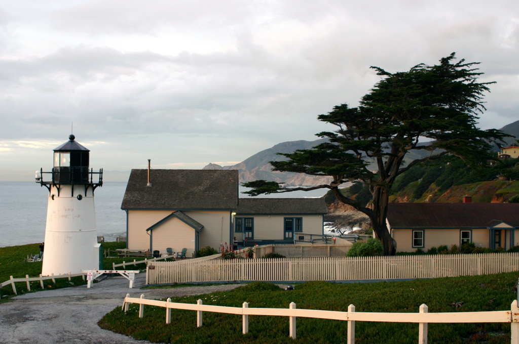
Point Montara Light
is a lighthouse in Montara, located just west of the Cabrillo Highway at Point Montara. Montara Light was originally established in 1875 as a fog signal station after several ships ran ashore in the late 1860s. The cast-iron lighthouse was brought from Wellfleet Harbor, Cape Cod
, Massachusetts
in 1925. It continues to operate as an aid-to-navigation maintained by the U.S. Coast Guard. The lighthouse demarks the northern point of the Fitzgerald Marine Reserve
, a holding of Special Biological Significance owned by the State of California.
Census-designated place
A census-designated place is a concentration of population identified by the United States Census Bureau for statistical purposes. CDPs are delineated for each decennial census as the statistical counterparts of incorporated places such as cities, towns and villages...
(CDP) in San Mateo County
San Mateo County, California
San Mateo County is a county located in the San Francisco Bay Area of the U.S. state of California. It covers most of the San Francisco Peninsula just south of San Francisco, and north of Santa Clara County. San Francisco International Airport is located at the northern end of the county, and...
, California
California
California is a state located on the West Coast of the United States. It is by far the most populous U.S. state, and the third-largest by land area...
, United States
United States
The United States of America is a federal constitutional republic comprising fifty states and a federal district...
. The population was 2,909 at the 2010 census. Nearby communities include Moss Beach and Princeton-by-the-Sea.
Geography and environment
Montara is located at 37°32′23"N 122°30′23"W (37.539639, -122.506426), approximately 20 miles (32.2 km) south of San FranciscoSan Francisco, California
San Francisco , officially the City and County of San Francisco, is the financial, cultural, and transportation center of the San Francisco Bay Area, a region of 7.15 million people which includes San Jose and Oakland...
and 50 miles (80.5 km) north of Santa Cruz, California
Santa Cruz, California
Santa Cruz is the county seat and largest city of Santa Cruz County, California in the US. As of the 2010 U.S. Census, Santa Cruz had a total population of 59,946...
. Neighboring towns include Pacifica
Pacifica, California
Pacifica is a city in San Mateo County, California, on the coast of the Pacific Ocean between San Francisco and Half Moon Bay.-Overview:The City of Pacifica is spread along a six mile stretch of the north central California coastal beach and hills, nestled in several small valleys spanning between...
to the north, Moss Beach
Moss Beach, California
Moss Beach is a coastal census-designated place in San Mateo County, California, with a year 2010 census population of 3,103. Located in Moss Beach are the Fitzgerald Marine Reserve, a marine sanctuary; the Half Moon Bay Airport, the historic Moss Beach Distillery and the Seal Cove Inn, a...
, El Granada
El Granada, California
El Granada is a census-designated place in the coastal area of northern San Mateo County, California, United States. The population was 5,467 at the 2010 census.-Geography:...
, and Half Moon Bay
Half Moon Bay, California
Half Moon Bay is a coastal city in San Mateo County, California, USA. Its population was 11,324 as of the 2010 census. Immediately at the north of Half Moon Bay is the Pillar Point Harbor and the unincorporated community of Princeton-by-the-Sea....
to the south. According to the United States Census Bureau
United States Census Bureau
The United States Census Bureau is the government agency that is responsible for the United States Census. It also gathers other national demographic and economic data...
, the CDP has a total area of 3.9 square miles (10.1 km²), all of it land.
The rare
Rare species
A rare species is a group of organisms that are very uncommon or scarce. This designation may be applied to either a plant or animal taxon, and may be distinct from the term "endangered" or "threatened species" but not "extinct"....
and endangered species
Endangered species
An endangered species is a population of organisms which is at risk of becoming extinct because it is either few in numbers, or threatened by changing environmental or predation parameters...
Hickman's potentilla
Hickman's potentilla
Potentilla hickmanii is an endangered perennial herb of the rose family. This rare plant species is found in a narrowly restricted range in two locations in coastal northern California, in Monterey County, and in very small colonies in San Mateo County...
occurs at the northern extremity of Montara on the slopes above Martini Creek
Martini Creek
Martini Creek is a coastal stream whose watershed lies entirely within San Mateo County, California, United States on the western exposures of the Montara mountain block, discharging to the Pacific Ocean. It flows about from its source on Montara Mountain to its mouth in Montara State Beach. This...
at elevations ranging from 32 to 410 feet (10 to 125 meters).
Nearby Montara Mountain
Montara Mountain
Montara Mountain, positioned between the unincorporated community of Montara, California to the southwest and the city of Pacifica, California to the north, forms the northern spur of the Santa Cruz Mountains, a narrow mountain range running the length of the San Francisco Peninsula that separates...
, part of the Santa Cruz Mountains
Santa Cruz Mountains
The Santa Cruz Mountains, part of the Pacific Coast Ranges, are a mountain range in central California, United States. They form a ridge along the San Francisco Peninsula, south of San Francisco, separating the Pacific Ocean from San Francisco Bay and the Santa Clara Valley, and continuing south,...
, rises to an elevation of 1,898 feet (578 m) above sea level. The mountain is accessible by a gravel fire road. On a few occasions light snowfall has fallen on the upper reaches of the mountain; this happened in February 2011 and was documented in videos and photographs on Youtube
YouTube
YouTube is a video-sharing website, created by three former PayPal employees in February 2005, on which users can upload, view and share videos....
and Google
Google
Google Inc. is an American multinational public corporation invested in Internet search, cloud computing, and advertising technologies. Google hosts and develops a number of Internet-based services and products, and generates profit primarily from advertising through its AdWords program...
.
The town is surrounded by open space (Rancho Corral del Tierra) and a popular recreation area includes Montara State Beach
Montara State Beach
Montara State Beach is a beach located eight miles north of Half Moon Bay on State Route 1, USA.Operated by California State Department of Parks and Recreation under the San Mateo Coast Sector Office...
. The nearly mile long stretch of sand drops steeply into the ocean making it hazardous for swimming. It is, however, a fairly popular surfing destination for experienced surfers. 10-15+ ft. waves can be common during winter storm swells.
Climate
Montara enjoys exceptionally mild weather throughout the year. Typical of central California, most of the rainfall falls from November through April, normally totaling more than 27 inches (69 cm). Due to its proximity to the Pacific OceanPacific Ocean
The Pacific Ocean is the largest of the Earth's oceanic divisions. It extends from the Arctic in the north to the Southern Ocean in the south, bounded by Asia and Australia in the west, and the Americas in the east.At 165.2 million square kilometres in area, this largest division of the World...
, heavy fogs and low overcasts are common throughout the year, sometimes producing light drizzle. Stray showers sometimes occur during the summer months, which are mostly dry. January, the coldest month, normally has high temperatures in the upper fifties (~14°C) and low temperatures in the middle forties (~8°C). Freezing temperatures are extremely rare, especially near the ocean. September, the warmest month, normally has high temperatures in the upper sixties (~20°C) and lows in the lower fifties (~11°C). Temperatures rarely exceed 90°F (32°C) and whenever there are daytime temperatures above 80°F (27°C) it still cools to the fifties (~13°C) at night. During experimental observations by a U.S. Geological Survey volunteer (from 1985 to 1989), the highest temperature was an amazing 100°F (38°C) and the lowest was 31°F (-0.5°C). The nearest official National Weather Service
National Weather Service
The National Weather Service , once known as the Weather Bureau, is one of the six scientific agencies that make up the National Oceanic and Atmospheric Administration of the United States government...
station is at Half Moon Bay
Half Moon Bay, California
Half Moon Bay is a coastal city in San Mateo County, California, USA. Its population was 11,324 as of the 2010 census. Immediately at the north of Half Moon Bay is the Pillar Point Harbor and the unincorporated community of Princeton-by-the-Sea....
. Recently, an automated weather station was set up in Montara, providing regular observations on the National Weather Service's website, weather.gov.
2010
The 2010 United States Census reported that Montara had a population of 2,909. The population densityPopulation density
Population density is a measurement of population per unit area or unit volume. It is frequently applied to living organisms, and particularly to humans...
was 750.1 people per square mile (289.6/km²). The racial makeup of Montara was 2,491 (85.6%) White, 16 (0.6%) African American, 21 (0.7%) Native American, 142 (4.9%) Asian, 1 (0.0%) Pacific Islander, 97 (3.3%) from other races
Race (United States Census)
Race and ethnicity in the United States Census, as defined by the Federal Office of Management and Budget and the United States Census Bureau, are self-identification data items in which residents choose the race or races with which they most closely identify, and indicate whether or not they are...
, and 141 (4.8%) from two or more races. Hispanic or Latino of any race were 324 persons (11.1%).
The Census reported that 2,909 people (100% of the population) lived in households, 0 (0%) lived in non-institutionalized group quarters, and 0 (0%) were institutionalized.
There were 1,109 households, out of which 351 (31.7%) had children under the age of 18 living in them, 666 (60.1%) were opposite-sex married couples
Marriage
Marriage is a social union or legal contract between people that creates kinship. It is an institution in which interpersonal relationships, usually intimate and sexual, are acknowledged in a variety of ways, depending on the culture or subculture in which it is found...
living together, 77 (6.9%) had a female householder with no husband present, 46 (4.1%) had a male householder with no wife present. There were 59 (5.3%) unmarried opposite-sex partnerships
POSSLQ
POSSLQ is an abbreviation for "Persons of Opposite Sex Sharing Living Quarters," a term coined in the late 1970s by the United States Census Bureau as part of an effort to more accurately gauge the prevalence of cohabitation in American households....
, and 17 (1.5%) same-sex married couples or partnerships. 209 households (18.8%) were made up of individuals and 72 (6.5%) had someone living alone who was 65 years of age or older. The average household size was 2.62. There were 789 families
Family (U.S. Census)
A family or family household is defined by the United States Census Bureau for statistical purposes as "a householder and one or more other people related to the householder by birth, marriage, or adoption. They do not include same-sex married couples even if the marriage was performed in a state...
(71.1% of all households); the average family size was 3.02.
The population was spread out with 617 people (21.2%) under the age of 18, 169 people (5.8%) aged 18 to 24, 622 people (21.4%) aged 25 to 44, 1,145 people (39.4%) aged 45 to 64, and 356 people (12.2%) who were 65 years of age or older. The median age was 46.0 years. For every 100 females there were 92.5 males. For every 100 females age 18 and over, there were 90.0 males.
There were 1,167 housing units at an average density of 300.9 per square mile (116.2/km²), of which 898 (81.0%) were owner-occupied, and 211 (19.0%) were occupied by renters. The homeowner vacancy rate was 0.9%; the rental vacancy rate was 5.3%. 2,409 people (82.8% of the population) lived in owner-occupied housing units and 500 people (17.2%) lived in rental housing units.
2000
As of the censusCensus
A census is the procedure of systematically acquiring and recording information about the members of a given population. It is a regularly occurring and official count of a particular population. The term is used mostly in connection with national population and housing censuses; other common...
of 2000, there were 2,950 people, 1,010 households, and 756 families residing in the CDP. The population density
Population density
Population density is a measurement of population per unit area or unit volume. It is frequently applied to living organisms, and particularly to humans...
was 751.0 people per square mile (289.8/km²). There were 1,034 housing units at an average density of 263.2 per square mile (101.6/km²). The racial makeup of the CDP in 2010 was 79.2% non-Hispanic White, 0.5% non-Hispanic African American, 0.3% Native American, 4.8% Asian, 0.2% from other races
Race (United States Census)
Race and ethnicity in the United States Census, as defined by the Federal Office of Management and Budget and the United States Census Bureau, are self-identification data items in which residents choose the race or races with which they most closely identify, and indicate whether or not they are...
, and 3.6% from two or more races. Hispanic or Latino of any race were 11.1% of the population.
There were 1,010 households out of which 40.9% had children under the age of 18 living with them, 63.4% were married couples
Marriage
Marriage is a social union or legal contract between people that creates kinship. It is an institution in which interpersonal relationships, usually intimate and sexual, are acknowledged in a variety of ways, depending on the culture or subculture in which it is found...
living together, 7.8% had a female householder with no husband present, and 25.1% were non-families. 15.7% of all households were made up of individuals and 2.7% had someone living alone who was 65 years of age or older. The average household size was 2.80 and the average family size was 3.10.
In the CDP the population was spread out with 25.4% under the age of 18, 4.7% from 18 to 24, 28.7% from 25 to 44, 32.5% from 45 to 64, and 8.6% who were 65 years of age or older. The median age was 41 years. For every 100 females there were 93.2 males. For every 100 females age 18 and over, there were 93.3 males.
The median income for a household in the CDP was $95,326, and the median income for a family was $100,881. Males had a median income of $67,708 versus $50,704 for females. The per capita income
Per capita income
Per capita income or income per person is a measure of mean income within an economic aggregate, such as a country or city. It is calculated by taking a measure of all sources of income in the aggregate and dividing it by the total population...
for the CDP was $44,360. About 0.5% of families and 2.4% of the population were below the poverty line, including 0.5% of those under age 18 and none of those age 65 or over.
Politics
In the state legislatureCalifornia State Legislature
The California State Legislature is the state legislature of the U.S. state of California. It is a bicameral body consisting of the lower house, the California State Assembly, with 80 members, and the upper house, the California State Senate, with 40 members...
Montara is located in the 8th Senate
California State Senate
The California State Senate is the upper house of the California State Legislature. There are 40 state senators. The state legislature meets in the California State Capitol in Sacramento. The Lieutenant Governor is the ex officio President of the Senate and may break a tied vote...
District, represented by Democrat
Democratic Party (United States)
The Democratic Party is one of two major contemporary political parties in the United States, along with the Republican Party. The party's socially liberal and progressive platform is largely considered center-left in the U.S. political spectrum. The party has the lengthiest record of continuous...
Leland Yee
Leland Yee
Leland Yee is a California State Senator in District 8 which represents the western half of San Francisco and most of San Mateo County. Prior to becoming state senator, Yee was a California State Assemblyman, Supervisor of San Francisco's Sunset District, and was a member and President of the San...
, and in the 19th Assembly
California State Assembly
The California State Assembly is the lower house of the California State Legislature. There are 80 members in the Assembly, representing an approximately equal number of constituents, with each district having a population of at least 420,000...
District, represented by Democrat Jerry Hill
Jerry Hill (Politician)
Jerry Hill is a Democratic state assemblyman representing California's 19th assembly district since December 2008. The district includes the cities of San Mateo, Burlingame, Brisbane, Daly City, Foster City, Millbrae, San Bruno, South San Francisco, Half Moon Bay, Pacifica, and Belmont.- Personal...
. Federally, Montara is located in California's 12th congressional district
California's 12th congressional district
California's 12th congressional district is a congressional district in the U.S. state of California that spans from the southwestern portions of San Francisco in the north down to San Mateo in the south, and from Moss Beach in the west to the edge of San Mateo in the east, where it borders...
, which has a Cook PVI
Cook Partisan Voting Index
The Cook Partisan Voting Index , sometimes referred to as simply the Partisan Voting Index , is a measurement of how strongly an American congressional district or state leans toward one political party compared to the nation as a whole...
of D +22 and is currently represented by Jackie Speier
Jackie Speier
Karen Lorraine Jacqueline "Jackie" Speier is the U.S. Representative for , serving since 2008. She is a member of the Democratic Party. The district includes the northern two-thirds of San Mateo County and the southwest quarter of San Francisco.She is also a former member of the California State...
.
Montara is an unincorporated community. All planning and zoning is the responsibility of the San Mateo County
San Mateo County, California
San Mateo County is a county located in the San Francisco Bay Area of the U.S. state of California. It covers most of the San Francisco Peninsula just south of San Francisco, and north of Santa Clara County. San Francisco International Airport is located at the northern end of the county, and...
Board of Supervisors, which is elected at large by the voters of San Mateo County. The Midcoast Community Council is an elected advisory body to the Board of Supervisors, is chosen by residents of Montara, Moss Beach, and El Granada.
Montara is also part of the Cabrillo Unified School District, Coastside Fire Protection District, Montara Water and Sanitary District, and the Midpeninsula Regional Open Space District. Because it is in the coastal zone, Montara is under the jurisdiction of the California Coastal Commission
California Coastal Commission
The California Coastal Commission is a state agency in the U.S. state of California with quasi-judicial regulatory oversight over land use and public access in the California coastal zone....
.
History
A lighthouse was established at Point Montara in 1875. The Montara area was first settled by farmers in the late nineteenth century. A commercial flower farm, still in operation, was established in 1900. In 1905, Montara became a stop on the new Ocean Shore RailroadOcean Shore Railroad
The Ocean Shore Railroad was intended to be built from San Francisco to Santa Cruz, California, via a route along the Pacific coastline.-History:...
, then under construction. The railroad built a hotel next to the train station. The trains encouraged weekend visitors to the area, but development of the community was very slow. The railroad went bankrupt and ceased operations in 1920, but the hotel remained and, although greatly remodeled, is still standing today, between State Route 1 and Main Street.
The Montara Grammar School opened in 1915; the historic two-story building still stands, serving as a community center. The newer Farallone View Elementary School, a few blocks north of the original school, services the town's children today.
California's second paved highway, Pedro Mountain Road
Pedro Mountain Road
Pedro Mountain Road describes a series of historical road crossings of Pedro Mountain, a promontory ridge located between Montara Mountain and the coastal cliffs of Devil's Slide in San Mateo County, California. This Pedro Mountain headland blocks the easy passage of coastal travelers between the...
, was completed in 1914, providing another connection between Montara and San Francisco. This highway was replaced in 1937 by State Route 1, which followed the old railroad route through the Devil's Slide; a tunnel is being built to replace this dangerous route, which has been closed periodically due to landslides.
Real growth in Montara began in the 1950s as more people moved away from San Francisco during the postwar boom. As Montara has continued to grow, the community has still maintained its generally rural image. Most of Montara's streets were dirt or gravel until the early 1990s; the rustic quality of the town has not been lost since the streets were oiled or paved (only some of the streets are actually paved).
Notable
In 2003, Montara Water and Sanitary District purchased its water system from the German industrial firm RWE. Montara and Moss Beach residents overwhelmingly supported a bond for the purchase and repair of the system. The high, spiraling rates and a decades-long water moratorium were key motivations behind the bond measure.Point Montara Light
Point Montara Light
The Point Montara Light is a lighthouse in Montara, California, United States, on the southern approach to the San Francisco Bay, California approximately 25 miles south of San Francisco.-History:...
is a lighthouse in Montara, located just west of the Cabrillo Highway at Point Montara. Montara Light was originally established in 1875 as a fog signal station after several ships ran ashore in the late 1860s. The cast-iron lighthouse was brought from Wellfleet Harbor, Cape Cod
Cape Cod
Cape Cod, often referred to locally as simply the Cape, is a cape in the easternmost portion of the state of Massachusetts, in the Northeastern United States...
, Massachusetts
Massachusetts
The Commonwealth of Massachusetts is a state in the New England region of the northeastern United States of America. It is bordered by Rhode Island and Connecticut to the south, New York to the west, and Vermont and New Hampshire to the north; at its east lies the Atlantic Ocean. As of the 2010...
in 1925. It continues to operate as an aid-to-navigation maintained by the U.S. Coast Guard. The lighthouse demarks the northern point of the Fitzgerald Marine Reserve
Fitzgerald Marine Reserve
Fitzgerald Marine Reserve is a marine reserve in California on the Pacific Ocean, located just north of Pillar Point Harbor and Mavericks in the San Mateo County community of Moss Beach. Moss Beach is located approximately south of San Francisco and north of Santa Cruz. The reserve is a holding...
, a holding of Special Biological Significance owned by the State of California.