
Watsons Bay, New South Wales
Encyclopedia
Watsons Bay is a harbourside, eastern
suburb
of Sydney
, in the state of New South Wales
, Australia
. Watsons Bay is located 11 km north-east of the Sydney central business district
, in the local government area of the Municipality of Woollahra
.
Watsons Bay sits on the end of the South Head
peninsula and takes its name from the sheltered bay
and anchor
age on its western side, in Port Jackson
(Sydney Harbour). It provides views across the harbour to the Sydney Harbour Bridge
. The Gap is an ocean cliff on the eastern side with views to Manly
at North Head
and the Pacific Ocean
. Vaucluse
is the only adjacent suburb, to the south.
people. The Cadigal referred to the area as Kutti. This indigenous group of people fished and collected shellfish in the waters and bays off South Head. They acquired their resources from Camp Cove and carved rock engravings
there, which have since eroded from the cliff faces and rock surfaces that line the coastline.
, when he had to beach his three vessels at Camp Cove for many years because of their being potentially sold by the Provost Marshal
. Watson was appointed harbour pilot and harbourmaster
of the port of Sydney in 1811 and the first superintendent of Macquarie Lighthouse
in 1816.
The first grant of 20 acres (80,937.2 m²) was made to Edward Laing in 1793 in the Camp Cove Area. Watsons Bay was an isolated fishing village until development began in the 1860s.
On the night of 20 August 1857, Dunbar
a sailing ship became shipwrecked against the cliffs below The Gap, with 121 lives lost. The Dunbar had mistaken the bay of The Gap for the harbour entrance. In 1910, at Jacob’s Ladder, the anchor from the ship was recovered along with other relics and were placed in a museum behind the old Town Hall in Military Road by Vaucluse Council. The anchor was transferred to the cliffs of Gap Park by Ald. Coombes and a memorial was unveiled in August 1930.
Today, The Gap is known as a notorious suicide spot, with about 50 deaths occurring there each year.
The line from the city commenced with a loop at the corner of Erskine and Day Sts near Wynyard Station
. It then proceeded south down Day St before turning left into King St passing through Queen's Square at St James Station. It then made a right hand turn into College St
, and headed south before turning left into Boomerang St. The line then continued left into William St
, through King's Cross
and then along Bayswater Rd
and into New South Head Rd
at Rushcutters Bay
. The line then followed the course of New and Old South Head Road
before turning right into Gap Park. After turning right into Gap Park a single track passed through narrow rock cuttings, low cliffs and rugged back-drops, turning its way down to the terminus at Watsons Bay.
The line had its own depot and city terminus and operated independently, although it was connected to the main Sydney tram network. In 1949, the line from Rose Bay to Watsons Bay closed, but reopened in 1950 due to public protest. In 1950, the line down King St to Erskine St closed and a new terminus constructed at Queens Square. The remainder of the line closed in 1960, the tracks were removed and in 1964 the Council re-vegetated the area around the former tramway cutting in gap park with the object of restoring the area.
When walking up the steps to The Gap at Watsons Bay, there is flat ground in between two sets of steps. This continues for a fair way in both directions, and is the old tram right of way.
The present-day route of buses 324 and L24 follow the route of the former tram line as far as the point where the tramway turned off Old South Head Road into Gap Park. The bus and tram routes meet again near the terminus in Military Rd.
 In 1942 during the Second World War the Sydney Harbour anti-submarine boom net was constructed on Georges Head and was designed to prevent enemy submarines from entering into Sydney Harbour. The boom net spanned the entire width of Port Jackson and a boom net winch house was located on Liangs Point, Watsons Bay. On the night of 31 May 1942, three Japan
ese midget submarine
s attempted to enter Sydney Harbour in what became known as the Attack on Sydney Harbour. One of the Japanese midget submarines became entangled in the boom net and after unsuccessful attempts to free the submarine, the crew detonated charges within the sub, killing themselves and destroying their sub in the process.
During this period Nielsen Park was used as an anti-aircraft base. The base had its own interim wooden barracks, searchlight
s and anti-aircraft guns.
In Gap Park, a gun emplacement for a small calibre gun, which was never installed was also intended for use during World War II.
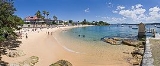
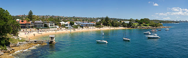 Watsons Bay is a mostly residential area with some recreational areas and beaches, including Camp Cove and a legal nude beach located at Lady Bay. Some restaurants, cafes and a hotel are located here. The coastal walk with ocean views of the Gap along South Head make Watsons Bay a popular tourist attraction in Sydney
. The Sydney Harbour Pilot Boat Station was located on the bay, and the naval training base HMAS Watson
is located nearby at South Head.
 Watsons Bay has a large number of heritage buildings, with the following buildings listed on the Register of the National Estate
:
Eastern Suburbs (Sydney)
The Eastern Suburbs is a general term used to describe the metropolitan area directly to the east and south-east of the Sydney central business district in Sydney, New South Wales, Australia. Eastern Suburbs can refer to the suburbs within the local government areas of Woollahra, Waverley, Dover...
suburb
Suburb
The word suburb mostly refers to a residential area, either existing as part of a city or as a separate residential community within commuting distance of a city . Some suburbs have a degree of administrative autonomy, and most have lower population density than inner city neighborhoods...
of Sydney
Sydney
Sydney is the most populous city in Australia and the state capital of New South Wales. Sydney is located on Australia's south-east coast of the Tasman Sea. As of June 2010, the greater metropolitan area had an approximate population of 4.6 million people...
, in the state of New South Wales
New South Wales
New South Wales is a state of :Australia, located in the east of the country. It is bordered by Queensland, Victoria and South Australia to the north, south and west respectively. To the east, the state is bordered by the Tasman Sea, which forms part of the Pacific Ocean. New South Wales...
, Australia
Australia
Australia , officially the Commonwealth of Australia, is a country in the Southern Hemisphere comprising the mainland of the Australian continent, the island of Tasmania, and numerous smaller islands in the Indian and Pacific Oceans. It is the world's sixth-largest country by total area...
. Watsons Bay is located 11 km north-east of the Sydney central business district
Sydney central business district
The Sydney central business district is the main commercial centre of Sydney, New South Wales, Australia. It extends southwards for about 3 kilometres from Sydney Cove, the point of first European settlement. Its north–south axis runs from Circular Quay in the north to Central railway station in...
, in the local government area of the Municipality of Woollahra
Municipality of Woollahra
The Municipality of Woollahra is a Local Government Area in the Eastern Suburbs of Sydney, in the state of New South Wales, Australia. The administrative centre of the Municipality of Woollahra is located on New South Head Road at Double Bay....
.
Watsons Bay sits on the end of the South Head
Sydney Heads
Sydney Heads , is the entrance to Port Jackson in Sydney, New South Wales, Australia.North Head and Quarantine Head are to the north, South Head and Dunbar Head are to the south. Middle Head, Georges Head and Chowder Head are to the west and within the bay...
peninsula and takes its name from the sheltered bay
Bay
A bay is an area of water mostly surrounded by land. Bays generally have calmer waters than the surrounding sea, due to the surrounding land blocking some waves and often reducing winds. Bays also exist as an inlet in a lake or pond. A large bay may be called a gulf, a sea, a sound, or a bight...
and anchor
Anchor
An anchor is a device, normally made of metal, that is used to connect a vessel to the bed of a body of water to prevent the vessel from drifting due to wind or current. The word derives from Latin ancora, which itself comes from the Greek ἄγκυρα .Anchors can either be temporary or permanent...
age on its western side, in Port Jackson
Port Jackson
Port Jackson, containing Sydney Harbour, is the natural harbour of Sydney, Australia. It is known for its beauty, and in particular, as the location of the Sydney Opera House and Sydney Harbour Bridge...
(Sydney Harbour). It provides views across the harbour to the Sydney Harbour Bridge
Sydney Harbour Bridge
The Sydney Harbour Bridge is a steel through arch bridge across Sydney Harbour that carries rail, vehicular, bicycle and pedestrian traffic between the Sydney central business district and the North Shore. The dramatic view of the bridge, the harbour, and the nearby Sydney Opera House is an iconic...
. The Gap is an ocean cliff on the eastern side with views to Manly
Manly, New South Wales
Manly is a suburb of northern Sydney, in the state of New South Wales, Australia. Manly is located 17 kilometres north-east of the Sydney central business district and is the administrative centre of the local government area of Manly Council, in the Northern Beaches region.-History:Manly was named...
at North Head
Sydney Heads
Sydney Heads , is the entrance to Port Jackson in Sydney, New South Wales, Australia.North Head and Quarantine Head are to the north, South Head and Dunbar Head are to the south. Middle Head, Georges Head and Chowder Head are to the west and within the bay...
and the Pacific Ocean
Pacific Ocean
The Pacific Ocean is the largest of the Earth's oceanic divisions. It extends from the Arctic in the north to the Southern Ocean in the south, bounded by Asia and Australia in the west, and the Americas in the east.At 165.2 million square kilometres in area, this largest division of the World...
. Vaucluse
Vaucluse, New South Wales
Vaucluse is an eastern suburb of Sydney, in the state of New South Wales, Australia. Vaucluse is located north-east of the Sydney central business district, in the local government areas of Waverley Council and the Municipality of Woollahra....
is the only adjacent suburb, to the south.
Aboriginal history
The original inhabitants of the area that is now known as Watsons Bay, were the CadigalCadigal
The Cadigal, also spelled as Gadigal, are a group of Aboriginal Australians who originally inhabited the area that they called 'Cadi', part of which later became known as the Marrickville Local Government Area of Sydney. Cadigal territory lies south of Port Jackson and stretches from South Head to...
people. The Cadigal referred to the area as Kutti. This indigenous group of people fished and collected shellfish in the waters and bays off South Head. They acquired their resources from Camp Cove and carved rock engravings
Sydney rock engravings
Sydney rock engravings are a form of Australian Aboriginal Rock Art consisting of carefully drawn images of people, animals, or symbols, in the sandstone around Sydney, New South Wales, Australia...
there, which have since eroded from the cliff faces and rock surfaces that line the coastline.
European settlement
Watsons Bay was named after Robert Watson (1756–1819), formerly of HMS SiriusHMS Sirius (1786)
HMS Sirius was the flagship of the First Fleet, which set out from Portsmouth, England, in 1787 to establish the first European colony in New South Wales, Australia. Sirius was wrecked off the coast of Norfolk Island in the Pacific Ocean in 1790....
, when he had to beach his three vessels at Camp Cove for many years because of their being potentially sold by the Provost Marshal
Provost Marshal
The Provost Marshal is the officer in the armed forces who is in charge of the military police .There may be a Provost Marshal serving at many levels of the hierarchy and he may also be the public safety officer of a military installation, responsible for the provision of fire, gate security, and...
. Watson was appointed harbour pilot and harbourmaster
Harbourmaster
A harbourmaster is an official responsible for enforcing the regulations of a particular harbour or port, in order to ensure the safety of navigation, the security of the harbour and the correct operation of the port facilities.-Responsibilities:Harbourmasters are normally responsible for issuing...
of the port of Sydney in 1811 and the first superintendent of Macquarie Lighthouse
Macquarie Lighthouse
The Macquarie Lighthouse, also known as South Head Upper Light, was the first, and is the longest serving, lighthouse site in Australia. It is located on Dunbar Head, Vaucluse near the entrance to Sydney Harbour. There has been a navigational aid in this vicinity since 1791 and a lighthouse near...
in 1816.
The first grant of 20 acres (80,937.2 m²) was made to Edward Laing in 1793 in the Camp Cove Area. Watsons Bay was an isolated fishing village until development began in the 1860s.
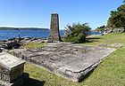
On the night of 20 August 1857, Dunbar
Dunbar (shipwreck)
The Dunbar was a full-rigged ship that was wrecked near the entrance to Sydney Harbour, Australia in 1857 with the loss of 121 lives.The Dunbar was launched on 30 November 1853 for London shipowner Duncan Dunbar and entered the passenger and cargo trade between London and Sydney early the following...
a sailing ship became shipwrecked against the cliffs below The Gap, with 121 lives lost. The Dunbar had mistaken the bay of The Gap for the harbour entrance. In 1910, at Jacob’s Ladder, the anchor from the ship was recovered along with other relics and were placed in a museum behind the old Town Hall in Military Road by Vaucluse Council. The anchor was transferred to the cliffs of Gap Park by Ald. Coombes and a memorial was unveiled in August 1930.
Today, The Gap is known as a notorious suicide spot, with about 50 deaths occurring there each year.
Trams
The City to Watsons bay tram line was extended from Edgecliffe to Signal Hill Station, Watsons Bay in 1903 with further extensions to Gap Park in 1909. The latter extension included a new tram terminus adjacent to The Gap and a tram cutting cut into the rock face in Gap Park that ran above and parallel to Gap Road that gradually descended to street level before terminating.The line from the city commenced with a loop at the corner of Erskine and Day Sts near Wynyard Station
Wynyard railway station, Sydney
Wynyard is a major underground CityRail station in the central business district of Sydney, Australia, 2.05 km from Central. Wynyard averages 108000 passenger movements per day Monday to Friday.-History:The station opened on 28 February 1932...
. It then proceeded south down Day St before turning left into King St passing through Queen's Square at St James Station. It then made a right hand turn into College St
College Street, Sydney
College Street in Sydney, New South Wales, Australia is a major street in the centre of the Central Business District. It runs from Queens Square near St James station to Whitlam Square at Liverpool St...
, and headed south before turning left into Boomerang St. The line then continued left into William St
William Street, Sydney
William Street is a major thoroughfare in Sydney, Australia. It runs from Kings Cross to Hyde Park where it turns into Park Street. The street forms the border between the two suburbs of Woolloomooloo and Darlinghurst. Today the newly completed Cross City Tunnel follows much of the route of William...
, through King's Cross
Kings Cross, New South Wales
Kings Cross is an inner-city locality of Sydney, New South Wales, Australia. It is located approximately 2 kilometres east of the Sydney central business district, in the local government area of the City of Sydney...
and then along Bayswater Rd
Bayswater Road, Sydney
Bayswater Road is a major street in the Kings Cross district of Sydney, New South Wales, Australia.The street is lined with nightspots, eateries, adult venues, dance clubs hotels, and is a popular destination for both Sydneysiders and tourists...
and into New South Head Rd
New South Head Road, Sydney
New South Head Road, is a major road in the Eastern Suburbs of Sydney, Australia. The road runs north-east from Rushcutters Bay through Edgecliff, Double Bay, Point Piper, Rose Bay and Vaucluse where it finally merges into Old South Head Road.-Maroo Track:...
at Rushcutters Bay
Rushcutters Bay, New South Wales
Rushcutters Bay is a harbourside eastern suburb of Sydney, in the state of New South Wales, Australia. Rushcutters Bay is located 3 kilometres east of the Sydney central business district, in the local government area of the City of Sydney....
. The line then followed the course of New and Old South Head Road
Old South Head Road, Sydney
Old South Head Road is a road in Sydney which goes from the suburb of Bondi Junction to Watsons Bay. It also passes through Bondi, Bondi Beach, North Bondi, Rose Bay and Vaucluse. It is historically significant because its earliest origins can be traced back to the early days of the colony...
before turning right into Gap Park. After turning right into Gap Park a single track passed through narrow rock cuttings, low cliffs and rugged back-drops, turning its way down to the terminus at Watsons Bay.
The line had its own depot and city terminus and operated independently, although it was connected to the main Sydney tram network. In 1949, the line from Rose Bay to Watsons Bay closed, but reopened in 1950 due to public protest. In 1950, the line down King St to Erskine St closed and a new terminus constructed at Queens Square. The remainder of the line closed in 1960, the tracks were removed and in 1964 the Council re-vegetated the area around the former tramway cutting in gap park with the object of restoring the area.
When walking up the steps to The Gap at Watsons Bay, there is flat ground in between two sets of steps. This continues for a fair way in both directions, and is the old tram right of way.
The present-day route of buses 324 and L24 follow the route of the former tram line as far as the point where the tramway turned off Old South Head Road into Gap Park. The bus and tram routes meet again near the terminus in Military Rd.
Sydney Harbour defences WWII
Japan
Japan is an island nation in East Asia. Located in the Pacific Ocean, it lies to the east of the Sea of Japan, China, North Korea, South Korea and Russia, stretching from the Sea of Okhotsk in the north to the East China Sea and Taiwan in the south...
ese midget submarine
Midget submarine
A midget submarine is any submarine under 150 tons, typically operated by a crew of one or two but sometimes up to 6 or 8, with little or no on-board living accommodation...
s attempted to enter Sydney Harbour in what became known as the Attack on Sydney Harbour. One of the Japanese midget submarines became entangled in the boom net and after unsuccessful attempts to free the submarine, the crew detonated charges within the sub, killing themselves and destroying their sub in the process.
During this period Nielsen Park was used as an anti-aircraft base. The base had its own interim wooden barracks, searchlight
Searchlight
A searchlight is an apparatus that combines a bright light source with some form of curved reflector or other optics to project a powerful beam of light of approximately parallel rays in a particular direction, usually constructed so that it can be swiveled about.-Military use:The Royal Navy used...
s and anti-aircraft guns.
In Gap Park, a gun emplacement for a small calibre gun, which was never installed was also intended for use during World War II.
Landmarks
Tourism in Sydney
Tourism in Sydney, Australia forms an important part of the city's economy. The city received 7 million domestic visitors and 2.7 million international visitors in year ending Dec 2010. The most well known attractions include the Sydney Opera House, and the Sydney Harbour Bridge. Other attractions...
. The Sydney Harbour Pilot Boat Station was located on the bay, and the naval training base HMAS Watson
HMAS Watson
HMAS Watson is a Royal Australian Navy base located on Sydney Harbour at South Head, near Watsons Bay, New South Wales. Commissioned in 1945 , the base served as the RAN's radar training school...
is located nearby at South Head.
Heritage
Register of the National Estate
The Register of the National Estate is a listing of natural and cultural heritage places in Australia. The listing was initially compiled between 1976 and 2003 by the Australian Heritage Commission. The register is now maintained by the Australian Heritage Council...
:
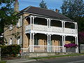
- Buildings 28-31, HMAS Watson
- Hornby Light House and two cottages, South Head
- St Peter's Church, Old South Head Road, designed by Edmund BlacketEdmund BlacketEdmund Thomas Blacket was an Australian architect, best known for his designs for the University of Sydney, St. Andrew's Cathedral, Sydney and St...
(1864) - Our Lady Star of the Sea Church, Old South Head Road (1909-1910)
- Scout hall, 335 Old South Head Road, former school designed by George Mansfield (1876)
- A former school residence designed by George Mansfield, Old South Head Road, (1876)
- Former marine station, Pacific Street and Laings Point, built and used by Nicholas Miklouho-Maclay (1885)
- Sandstone obelisk, Robertson Park, commemorating the construction of Old South Head Road (1811)