
Pennsylvania Route 54
Encyclopedia
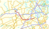
Pennsylvania Route 54 is a state highway
which runs for 70 miles (112.7 km) in eastern Pennsylvania
. It runs from U.S. Route 209 in Nesquehoning
, Carbon County
in the east to U.S. Route 15, which is three miles (5 km) west of Montgomery
, Lycoming County
in the west. PA 54 meets up with Pennsylvania Route 61
in Ashland
, running concurrent
for a short distance through the community before splitting just outside of Ashland. PA 54 continues west towards Pennsylvania Route 901
at Merrian while PA 61 heads north towards Centralia
. Prior to the current route, highways 54 and 61 were concurrent and went on the current route of 61 through Centralia and Mount Carmel
. Now it goes due west from Ashland and meets and concurs with route 901 westbound. After a several mile concurrency, route 901 bears left towards Excelsior outside of Shamokin
, while route 54 continues straight ahead. 54 and 61 intersect again in the village of Strong. The road then goes up Second Mountain through the village of Natalie. After going down and up another smaller hill, the road intersects with Pennsylvania Route 487
in Elysburg. The highway then crosses the north branch of the Susquehanna River
and into the borough of Danville
on Factory Street and Continental Boulevard (separated by Mahoning Street). Shortly after, it turns into an at-grade intersection four-lane highway crossing Pennsylvania Route 642
just before its interchange with Interstate 80
. Right before Washingtonville
it crosses Pennsylvania Route 254. Next it joins Pennsylvania Route 44
coming from the southeast and has a brief concurrency until the roads split off in Turbotville. Route 54 continues straight ahead, while Route 44 turns left. The road crosses the Susquehanna Trail
and immediately arrives at its Interstate 180
interchange. It then meets Pennsylvania Route 405
in Montgomery
and finally ends near Allenwood at the intersection with U.S. Route 15
.
, the original branch of Routes 54 and 61, which went from Centralia to Ashland, has been permanently closed because the road has severely opened up and buckled extensively. This branch was repaired in 1983 for $500,000; then in 1992 it was deemed too expensive to repair again. In 1994, the branch was permanently closed.
PA 54 used to run concurrent
with PA 61 through Centralia but was rerouted along Pennsylvania Route 901
and three quadrant routes in 1999, completely bypassing Centralia. Nowadays, only PA 61 goes through Centralia while PA 54 now goes directly from Ashland to Mount Carmel Township
along the aforementioned alignment via PA 901. The road signs for PA 54 were removed from Centralia several years ago.
Routes 54 and 61 meet up again at an intersection just outside of Mount Carmel
.
State highway
State highway, state road or state route can refer to one of three related concepts, two of them related to a state or provincial government in a country that is divided into states or provinces :#A...
which runs for 70 miles (112.7 km) in eastern Pennsylvania
Pennsylvania
The Commonwealth of Pennsylvania is a U.S. state that is located in the Northeastern and Mid-Atlantic regions of the United States. The state borders Delaware and Maryland to the south, West Virginia to the southwest, Ohio to the west, New York and Ontario, Canada, to the north, and New Jersey to...
. It runs from U.S. Route 209 in Nesquehoning
Nesquehoning, Pennsylvania
Nesquehoning is a borough in Carbon County, Pennsylvania, United States. The population was 3,288 at the 2000 census. The name is of Native American origin, commonly believed to signify "narrow valley;" however native language scholars translate the name as "at the black lick" or "at the dirty...
, Carbon County
Carbon County, Pennsylvania
As of the census of 2000, there were 58,802 people, 23,701 households, and 16,424 families residing in the county. The population density was 154 people per square mile . There were 30,492 housing units at an average density of 80 per square mile...
in the east to U.S. Route 15, which is three miles (5 km) west of Montgomery
Montgomery, Pennsylvania
Montgomery is a borough in Lycoming County, Pennsylvania, in the United States. The population was 1,695 at the 2000 census. It is part of the Williamsport, Pennsylvania Metropolitan Statistical Area.-History:...
, Lycoming County
Lycoming County, Pennsylvania
-Appalachian Mountains and Allegheny Plateau:Lycoming County is divided between the Appalachian Mountains in the south, the dissected Allegheny Plateau in the north and east, and the valley of the West Branch Susquehanna River between these.-West Branch Susquehanna River:The West Branch of the...
in the west. PA 54 meets up with Pennsylvania Route 61
Pennsylvania Route 61
Pennsylvania Route 61 is an -long state highway in the U.S. state of Pennsylvania. The route is signed on a north–south direction, from U.S. Route 222 Business in Reading to U.S. Route 11 and U.S. Route 15 in Shamokin Dam. PA 61 meets up with Pennsylvania Route 54 in Ashland and these...
in Ashland
Ashland, Pennsylvania
Ashland is a borough in Schuylkill county in the U.S. state of Pennsylvania, 12 miles northwest of Pottsville. The Borough lies in the anthracite coal region of eastern Pennsylvania. Settled in 1850, Ashland was incorporated in 1857, and was named for Henry Clay's estate near Lexington, Kentucky....
, running concurrent
Concurrency (road)
A concurrency, overlap, or coincidence in a road network is an instance of one physical road bearing two or more different highway, motorway, or other route numbers...
for a short distance through the community before splitting just outside of Ashland. PA 54 continues west towards Pennsylvania Route 901
Pennsylvania Route 901
Pennsylvania Route 901 is a long state route located in eastern Pennsylvania. The western terminus of the route is at Pennsylvania Route 61 in the Coal Township hamlet of Ranshaw. Its eastern terminus is at Pennsylvania Route 183 in Cressona....
at Merrian while PA 61 heads north towards Centralia
Centralia, Pennsylvania
Centralia is a borough and ghost town in Columbia County, Pennsylvania, United States. Its population has dwindled from over 1,000 residents in 1981 to 12 in 2005, 9 in 2007, and 10 in 2010, as a result of a mine fire burning beneath the borough since 1962...
. Prior to the current route, highways 54 and 61 were concurrent and went on the current route of 61 through Centralia and Mount Carmel
Mount Carmel, Pennsylvania
Mount Carmel is the name of a borough in Northumberland County, Pennsylvania, United States. The population was 6390 at the 2000 census. It is located 88 miles northwest of Philadelphia and 71 miles northeast of Harrisburg, in the Anthracite Coal Region...
. Now it goes due west from Ashland and meets and concurs with route 901 westbound. After a several mile concurrency, route 901 bears left towards Excelsior outside of Shamokin
Shamokin, Pennsylvania
Shamokin is a city in Northumberland County, Pennsylvania, at the western edge of the Anthracite Coal Region. At the 2000 census the population was 8,009 residents...
, while route 54 continues straight ahead. 54 and 61 intersect again in the village of Strong. The road then goes up Second Mountain through the village of Natalie. After going down and up another smaller hill, the road intersects with Pennsylvania Route 487
Pennsylvania Route 487
Pennsylvania Route 487 is a long, north–south state highway running from PA 61 in Shamokin Township, Northumberland County to PA 87 in Dushore, Sullivan County. In Bloomsburg, PA 487 and US 11 share a brief wrong-way concurrency...
in Elysburg. The highway then crosses the north branch of the Susquehanna River
Susquehanna River
The Susquehanna River is a river located in the northeastern United States. At long, it is the longest river on the American east coast that drains into the Atlantic Ocean, and with its watershed it is the 16th largest river in the United States, and the longest river in the continental United...
and into the borough of Danville
Danville, Pennsylvania
Danville is a borough in Montour County, Pennsylvania, USA, of which it is the county seat, on the North Branch of the Susquehanna River. Danville was home to 8,042 people in 1900, 7,517 people in 1910, and 7,122 people in 1940. The population was 4,897 at the 2000 census...
on Factory Street and Continental Boulevard (separated by Mahoning Street). Shortly after, it turns into an at-grade intersection four-lane highway crossing Pennsylvania Route 642
Pennsylvania Route 642
Pennsylvania Route 642 is an long state highway located in Union, Northumberland, Montour, and Columbia counties in Pennsylvania. The western terminus is at US 15 in Kelly Township. The eastern terminus is at PA 254 in Madison Township....
just before its interchange with Interstate 80
Interstate 80 in Pennsylvania
The transcontinental Interstate 80 is designated across northern Pennsylvania as the Keystone Shortway, officially the Z.H. Confair Memorial Highway. This route was built mainly along a completely new alignment, not paralleling any earlier U.S. Routes, as a shortcut to the tolled Pennsylvania...
. Right before Washingtonville
Washingtonville, Pennsylvania
Washingtonville is a borough in Montour County, Pennsylvania, United States. The population was 201 at the 2000 census. It is part of the Bloomsburg–Berwick Micropolitan Statistical Area.-History:...
it crosses Pennsylvania Route 254. Next it joins Pennsylvania Route 44
Pennsylvania Route 44
Pennsylvania Route 44 is a -long state highway in the U.S. state of Pennsylvania. The route is designated from Interstate 80 and Pennsylvania Route 42 in Buckhorn to the New York state line near New York State Route 417 in Ceres Township....
coming from the southeast and has a brief concurrency until the roads split off in Turbotville. Route 54 continues straight ahead, while Route 44 turns left. The road crosses the Susquehanna Trail
Susquehanna Trail
The Susquehanna Trail was an auto trail in the United States linking Washington, D.C. with Niagara Falls, New York. It passed through Baltimore, Maryland; Harrisburg, Pennsylvania; Williamsport, Pennsylvania; and Buffalo, New York....
and immediately arrives at its Interstate 180
Interstate 180 (Pennsylvania)
Interstate 180 is a spur highway that connects Williamsport, Pennsylvania to Interstate 80 near Milton, Pennsylvania. The length of the highway is . It was also the designation of present-day Interstate 176 between Morgantown, Pennsylvania and Reading, when the Pennsylvania Turnpike carried the...
interchange. It then meets Pennsylvania Route 405
Pennsylvania Route 405
Pennsylvania Route 405 is a state highway that runs for in north central Pennsylvania, United States. The southern terminus of Pennsylvania Route 147 in West Chillisquaque Township...
in Montgomery
Montgomery, Pennsylvania
Montgomery is a borough in Lycoming County, Pennsylvania, in the United States. The population was 1,695 at the 2000 census. It is part of the Williamsport, Pennsylvania Metropolitan Statistical Area.-History:...
and finally ends near Allenwood at the intersection with U.S. Route 15
U.S. Route 15 in Pennsylvania
U.S. Route 15 is a north-south U.S. Highway in Pennsylvania.-Route description:US 15 enters Pennsylvania south of Gettysburg, Adams County. The route heads to the north toward Harrisburg. It joins with U.S. 11 going along the west shore of the Susquehanna River until they split across the river...
.
Major intersections
Centralia branch of PA 54/61
Because of the underground coal mine fire in CentraliaCentralia, Pennsylvania
Centralia is a borough and ghost town in Columbia County, Pennsylvania, United States. Its population has dwindled from over 1,000 residents in 1981 to 12 in 2005, 9 in 2007, and 10 in 2010, as a result of a mine fire burning beneath the borough since 1962...
, the original branch of Routes 54 and 61, which went from Centralia to Ashland, has been permanently closed because the road has severely opened up and buckled extensively. This branch was repaired in 1983 for $500,000; then in 1992 it was deemed too expensive to repair again. In 1994, the branch was permanently closed.
PA 54 used to run concurrent
Concurrency (road)
A concurrency, overlap, or coincidence in a road network is an instance of one physical road bearing two or more different highway, motorway, or other route numbers...
with PA 61 through Centralia but was rerouted along Pennsylvania Route 901
Pennsylvania Route 901
Pennsylvania Route 901 is a long state route located in eastern Pennsylvania. The western terminus of the route is at Pennsylvania Route 61 in the Coal Township hamlet of Ranshaw. Its eastern terminus is at Pennsylvania Route 183 in Cressona....
and three quadrant routes in 1999, completely bypassing Centralia. Nowadays, only PA 61 goes through Centralia while PA 54 now goes directly from Ashland to Mount Carmel Township
Mount Carmel Township, Pennsylvania
Mount Carmel Township is a township located in Northumberland County, Pennsylvania, in the United States. Erected in 1854, it was named after Mount Carmel in Israel and was formed from out of part of Coal Township...
along the aforementioned alignment via PA 901. The road signs for PA 54 were removed from Centralia several years ago.
Routes 54 and 61 meet up again at an intersection just outside of Mount Carmel
Mount Carmel, Pennsylvania
Mount Carmel is the name of a borough in Northumberland County, Pennsylvania, United States. The population was 6390 at the 2000 census. It is located 88 miles northwest of Philadelphia and 71 miles northeast of Harrisburg, in the Anthracite Coal Region...
.
FYI
- Although signed east-west, at least half of PA 54 goes north-south, which mirrors PA 61 (signed north-south, but going mainly east-west)
- There are two instances where PA 54 leaves and enters the same county. It enters Montour CountyMontour County, PennsylvaniaMontour County is located in the U.S. state of Pennsylvania. In 2010, the county's population was 18,267. Its county seat is Danville. It is named for Andrew Montour, a prominent métis interpreter who served with George Washington during the French and Indian War. The county is part of the...
very briefly after leaving ElysburgElysburg, PennsylvaniaElysburg is a census-designated place in Northumberland County, Pennsylvania, United States. The population was 2,067 at the 2000 census. The area's biggest attraction is Knoebels Amusement Park, which has two wooden roller coasters.-Demographics:...
then goes back into Northumberland CountyNorthumberland County, PennsylvaniaThere were 38,835 households out of which 27.30% had children under the age of 18 living with them, 52.40% were married couples living together, 9.60% had a female householder with no husband present, and 34.10% were non-families. 30.20% of all households were made up of individuals and 15.50% had...
. After crossing the Susquehanna RiverSusquehanna RiverThe Susquehanna River is a river located in the northeastern United States. At long, it is the longest river on the American east coast that drains into the Atlantic Ocean, and with its watershed it is the 16th largest river in the United States, and the longest river in the continental United...
, it re-enters Mountour county until it crosses a county-line road into Northumberland County again right before TurbotvilleTurbotville, PennsylvaniaTurbotville is a borough in Northumberland County, Pennsylvania, United States. The population was 691 at the 2000 census.-Geography:Turbotville is located at ....
. - PA 54 clips the southwest corner of Columbia CountyColumbia County, PennsylvaniaAs of the census of 2000, there were 64,151 people, 24,915 households, and 16,568 families residing in the county. The population density was 132 people per square mile . There were 27,733 housing units at an average density of 57 per square mile...
between AshlandAshland, PennsylvaniaAshland is a borough in Schuylkill county in the U.S. state of Pennsylvania, 12 miles northwest of Pottsville. The Borough lies in the anthracite coal region of eastern Pennsylvania. Settled in 1850, Ashland was incorporated in 1857, and was named for Henry Clay's estate near Lexington, Kentucky....
and Mount CarmelMount Carmel, PennsylvaniaMount Carmel is the name of a borough in Northumberland County, Pennsylvania, United States. The population was 6390 at the 2000 census. It is located 88 miles northwest of Philadelphia and 71 miles northeast of Harrisburg, in the Anthracite Coal Region... - PA routes 54 and 61 meet in two separate occasions
- Before the new bridge was built between RiversideRiverside, PennsylvaniaRiverside is a borough in Northumberland County, Pennsylvania, United States. The population was 1,861 at the 2000 census. The current mayor is Dale E...
and DanvilleDanville, PennsylvaniaDanville is a borough in Montour County, Pennsylvania, USA, of which it is the county seat, on the North Branch of the Susquehanna River. Danville was home to 8,042 people in 1900, 7,517 people in 1910, and 7,122 people in 1940. The population was 4,897 at the 2000 census...
Route 54 went on an old truss bridge just to the east of the current bridge. After that, it ran on Mill street, then briefly concurred with US 11 until it intersected with Continental Boulevard and then turned on right on there.