
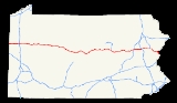
Interstate 80 in Pennsylvania
Encyclopedia
The transcontinental Interstate 80
is designated across northern Pennsylvania
as the Keystone Shortway, officially the Z.H. Confair Memorial Highway. This route was built mainly along a completely new alignment, not paralleling any earlier U.S. Routes, as a shortcut to the tolled
Pennsylvania Turnpike
and New York State Thruway
. It does not serve any major cities in Pennsylvania, and serves mainly as a cross-state route on the Ohio
-New York City
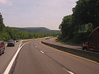
corridor. Most of I-80's path across the state goes through hilly and mountainous terrain, with relatively flat areas playing home to the freeway toward the western tier of the state.
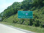
, 2,250 ft., although other interstate highways east of the Mississippi, including I-26
in North Carolina and Tennessee, reach higher elevations. This point is just east of Exit 111. A sign prominently displays this unusual fact about the Interstate.
Interstate 80 intersects cities such as DuBois
, Sharon
, Hazleton
, Stroudsburg
, and many other cities.
 The corridor now served by I-80 was originally to be a branch of the Pennsylvania Turnpike
from Sharon to Stroudsburg. Planning was shifted to the Pennsylvania Department of Highways in 1956 with the passage of the National Interstate and Defense Highways Act.
In early plans for the Interstate Highway System
, the connection across northern Pennsylvania would have paralleled U.S. Route 6N
and U.S. Route 6
from what became Interstate 90
near West Springfield, Pennsylvania east to Scranton. (From Scranton east to Hartford, Connecticut
, Interstate 84
was built parallel to US 6.) From Scranton a route went southeast along U.S. Route 611 to the Stroudsburg
area, and then east along U.S. Route 46
to near New York City. On May 22, 1957, a request by Pennsylvania to move the corridor south was approved by the Federal Highway Administration
. (The Scranton-Stroudsburg connection was kept, and the new alignment merged with it west of Stroudsburg.) However, when the initial numbers were assigned later that year, they were drawn on a 1947 map, and so the corridor across northern Pennsylvania became part of Interstate 84
, while the Scranton-New York route became Interstate 82. (I-80 ran along the Pennsylvania Turnpike
- later Interstate 80S - to Harrisburg, where it split into I-80S to Philadelphia and I-80N (later Interstate 78
) to New York.) This was corrected the next year, as the Keystone Shortway became part of I-80, and the southern route became I-80S (later I-76) and I-78. I-84 was truncated to Scranton, and the Scranton-Stroudsburg connection became Interstate 81E (later renumbered Interstate 380
).
The first section of present I-80 to open was the Delaware Water Gap Toll Bridge
, opened December 16, 1953. This had been built as part of U.S. Route 611 and connected back to its old alignment soon after crossing into Pennsylvania. Construction on the rest of I-80 began in 1959 and was completed in 1970.
In 1993, exit 43 (now exit 284) of I-80, which serves the Pocono Raceway
, was designated the Richard Petty
Interchange in honor of the NASCAR
legend that drove the #43 car.
On March 7, 2011, the supporting wall on the eastbound I-80 bridge over Sullivan Trail in Tannersville collapsed from snow and rain. As a result, eastbound I-80 was reduced to one lane and Sullivan Trail was closed.
proposed tolling Interstate 80 as a means of raising transportation revenue. It is seeking the permission to put tolls on the highway through a Federal Highway Administration
pilot program that allows three states to place tolls on interstates. Missouri's Interstate 70
and Virginia
had already taken two of the spots. Under the plan, the PTC would assume all maintenance and toll-taking operations on I-80. The plan calls for up to ten toll plazas along the length of I-80 in Pennsylvania with a toll rate of 8 cents per mile, which would be comparable to the rate on the Pennsylvania Turnpike following a projected toll increase. Originally, I-80 was part of the PTC's 1,000 Mile Turnpike system, but with the passage of the Interstate Highway Act in 1954, the PTC abandoned the 1000 miles (1,609.3 km) system and only maintained the original east–west Turnpike and its Northeastern Extension
. Currently the only toll on I-80 in Pennsylvania is at the Delaware Water Gap
bridge between Pennsylvania and New Jersey
. Tolling on I-80 would be completed by 2010. On October 15, 2007, the lease for the Pennsylvania Turnpike Commission to toll I-80 was signed.
This plan faced opposition from Northern Pennsylvania politicians who fear tolls will hurt the economy in the region and who do not want their tolls going toward funding mass transit. Congressmen John E. Peterson
and Phil English
have proposed a federal transportation bill that would ban the tolling of I-80. The chief executive officer of the Pennsylvania Turnpike Commission has promised that the tolls would be used on highway projects in Pennsylvania and not on mass transit. On December 12, 2007, the FHWA rejected the plan, and returned Pennsylvania's application for tolling I-80 with questions stating why the state should place tolls on the highway.
On September 11, 2008, the Federal Highway Administration rejected Pennsylvania's application to toll Interstate 80 for the second time.
On April 6, 2010, the Federal Highway Administration rejected this application for the third time.
|-
!rowspan=2|County
!rowspan=2|Location
!colspan=2|Exit
!rowspan=2|Destinations
!rowspan=2|Notes
|-
!Old
!New
|-
|rowspan=4|Mercer
|Shenango Township
|1
|4 A/B
|
|
|-
|East Lackawannock Township
|2
|15
|
|
|-
|Findley Township
|
|19 A/B
|
|
|-
|Worth Township
|3A
|24
|
|
|-
|rowspan=3|Venango
|Barkeyville
|3
|29
|
|
|-
|Clintonville
|4
|35
|
|
|-
|Scrubgrass Township
|5
|42
|
|
|-
|Butler
|colspan=5 align="center"|No interchanges
|-
|rowspan=6|Clarion
|Emlenton
|6
|45
|
|Eastbound ramps access PA-478; westbound ramps access PA-38/PA-208 concurrency and are in Venango County.
|-
|Beaver Township
|7
|53
|
|Connection to PA-338 via Canoe Ripple Road.
|-
|rowspan=4|Clarion Township
|8
|60
|
|PA-66 joins eastbound; leaves westbound.
|-
|9
|62
|
|
|-
|10
|64
|
|PA-66 leaves eastbound, joins westbound.
|-
|11
|70
|
|
|-
|rowspan=5|Jefferson
|Corsica
|12
|73
|
|
|-
|Brookville
|13
|78
|
|
|-
|Pine Creek Township
|14
|81
|
|
|-
|rowspan=2|Winslow Township
|15
|86
|Fuller Rd – Reynoldsville
|
|-
|
|90
| – DuBois Regional Airport
|
|-
|rowspan=6|Clearfield
|Sandy Township
|16
|97
|
|
|-
|Dubois
|17
|101
|
|
|-
|Pine Township
|18
|111
|
|
|-
|Plymptonville
|19
|120
|
|
|-
|Lawrence Township
|20
|123
|
|Alternative eastbound route to State College
and I-99 south.
|-
|Cooper Township
|21
|133
|
|
|-
|rowspan=3|Centre
|Snow Shoe
|22
|147
|
|
|-
|Boggs Township
|23
|158
|, Blanchard
|Alt US-220 joins eastbound; leaves westbound.
|-
|Spring Township
|24
|161
|
|Alt US-220 ends eastbound; begins westbound. US-220 joins eastbound; leaves westbound. Northern terminus (currently) of I-99.
|-
|rowspan=4|Clinton
|Porter Township
|25
|173
|
|
|-
|Lamar Township
|26
|178
|
|US-220 leaves eastbound, enters westbound.
|-
|rowspan=2|Greene Township
|27
|185
|
|
|-
|28
|192
|
|
|-
|rowspan=2|Union
|West Buffalo Township
|29
|199
|Mile Run Road
|Access to Bald Eagle State Forest
.
|-
|White Deer Township
|30
|210 A/B
|
|
|-
|rowspan=2|Northumberland
|Milton
|31
|212 B/A
|
|Northern terminus of PA 147; eastern terminus of I-180.
|-
|East Chillisquaque Township
|32
|215
|
|
|-
|Montour
|Valley Township
|33
|224
|
|
|-
|rowspan=4|Columbia
|Buckhorn
|34
|232
|
|
|-
|Bloomsburg
|35
|236
|
|
|-
|South Centre Township
|36
|241
|
|
|-
|Main Township
|37
|242
|
|
|-
|rowspan=4|Luzerne
|Sugarloaf Township
|38
|256
|
|
|-
|rowspan=2|Butler Township
|
|260 A/B
|
|
|-
|39
|262
|
|Access to Nescopeck State Park
.
|-
|White Haven
|40
|273
|
|
|-
|rowspan=2|Carbon
|rowspan=2|Kidder Township
|41
|274
| – Hickory Run State Park
|
|-
|42
|277
|
|Pocono Exit of PA Turnpike Northeast Extension
|-
|rowspan=14|Monroe
|Tunkhannock Township
|43
|284
|
|
|-
|Jackson Township
|
|293
|
|Southern terminus of I-380.
|-
|rowspan=2|Pocono Township
|44
|298
|
|Eastbound entrance and westbound exit.
|-
|45
|299
|
|Westbound entrance via Sullivan Trail.
|-
|Hamilton Township
|46
|302 A/B
|
|No westbound exit for PA-33/US-209 S (see exit 304), therefore not an AB exit westbound.
|-
|rowspan=2|Arlington Heights
|47
|303
|
|Eastbound exit and westbound entrance
|-
|47A
|304
|
|Eastbound entrance and westbound exit; US-209 joins eastbound, leaves westbound.
|-
|rowspan=3|Stroudsburg
|48
|305
|
|
|-
|49
|306
|Dreher Avenue – Stroudsburg
|Westbound exit and eastbound entrance
|-
|50
|307
|
|Eastbound exit to/from PA-611; westbound exit to/from PA-191
|-
|rowspan=2|East Stroudsburg
|51
|308
|Prospect Street – East Stroudsburg
|
|-
|52
|309
|
|US-209 leaves eastbound, joins westbound; southern terminus of PA-447.
|-
|rowspan=2|Delaware Water Gap
|53
|310
|
|Welcome Center (westbound); potential commuter rail park & ride to New York City and Scranton via the Lackawanna Cutoff.
|-
|colspan=4 align="center"|Delaware Water Gap Toll Bridge
over the Delaware River
; Toll westbound.
Interstate 80
Interstate 80 is the second-longest Interstate Highway in the United States, following Interstate 90. It is a transcontinental artery running from downtown San Francisco, California to Teaneck, New Jersey in the New York City Metropolitan Area...
is designated across northern Pennsylvania
Pennsylvania
The Commonwealth of Pennsylvania is a U.S. state that is located in the Northeastern and Mid-Atlantic regions of the United States. The state borders Delaware and Maryland to the south, West Virginia to the southwest, Ohio to the west, New York and Ontario, Canada, to the north, and New Jersey to...
as the Keystone Shortway, officially the Z.H. Confair Memorial Highway. This route was built mainly along a completely new alignment, not paralleling any earlier U.S. Routes, as a shortcut to the tolled
Toll road
A toll road is a privately or publicly built road for which a driver pays a toll for use. Structures for which tolls are charged include toll bridges and toll tunnels. Non-toll roads are financed using other sources of revenue, most typically fuel tax or general tax funds...
Pennsylvania Turnpike
Pennsylvania Turnpike
The Pennsylvania Turnpike is a toll highway system operated by the Pennsylvania Turnpike Commission in the Commonwealth of Pennsylvania, United States. The three sections of the turnpike system total . The main section extends from Ohio to New Jersey and is long...
and New York State Thruway
New York State Thruway
The New York State Thruway is a system of limited-access highways located within the state of New York in the United States. The system, known officially as the Governor Thomas E. Dewey Thruway for former New York Governor Thomas E. Dewey, is operated by the New York State Thruway Authority and...
. It does not serve any major cities in Pennsylvania, and serves mainly as a cross-state route on the Ohio
Ohio
Ohio is a Midwestern state in the United States. The 34th largest state by area in the U.S.,it is the 7th‑most populous with over 11.5 million residents, containing several major American cities and seven metropolitan areas with populations of 500,000 or more.The state's capital is Columbus...
-New York City
New York City
New York is the most populous city in the United States and the center of the New York Metropolitan Area, one of the most populous metropolitan areas in the world. New York exerts a significant impact upon global commerce, finance, media, art, fashion, research, technology, education, and...
corridor. Most of I-80's path across the state goes through hilly and mountainous terrain, with relatively flat areas playing home to the freeway toward the western tier of the state.
Route description
In Clearfield County, Interstate 80 reaches its highest elevation east of the Mississippi RiverMississippi River
The Mississippi River is the largest river system in North America. Flowing entirely in the United States, this river rises in western Minnesota and meanders slowly southwards for to the Mississippi River Delta at the Gulf of Mexico. With its many tributaries, the Mississippi's watershed drains...
, 2,250 ft., although other interstate highways east of the Mississippi, including I-26
Interstate 26
Interstate 26 is a nominally east–west main route of the Interstate Highway System in the Southeastern United States. I-26 runs from the junction of U.S. Route 11W and U.S. Route 23 in Kingsport, Tennessee, generally southeastward to U.S. Route 17 in Charleston, South Carolina...
in North Carolina and Tennessee, reach higher elevations. This point is just east of Exit 111. A sign prominently displays this unusual fact about the Interstate.
Interstate 80 intersects cities such as DuBois
DuBois, Pennsylvania
DuBois is a city in Clearfield County, Pennsylvania, northeast of Pittsburgh. It is the principal city in the DuBois, Pa Micropolitan Statistical Area.-History:...
, Sharon
Sharon, Pennsylvania
Sharon is a city in Mercer County, Pennsylvania, in the United States, northwest of Pittsburgh. It is part of the Youngstown–Warren–Boardman, OH-PA Metropolitan Statistical Area.- History :...
, Hazleton
Hazleton, Pennsylvania
Hazleton is a city in Luzerne County, Pennsylvania, United States. The population was 25,340 at the 2010 census, an increase of 8.6% from the 2000 census count .-Greater Hazleton:...
, Stroudsburg
Stroudsburg, Pennsylvania
Stroudsburg is a borough in Monroe County, Pennsylvania, United States. It is located in the Poconos region of the state, approximately five miles from the Delaware Water Gap, at the confluence of the Brodhead and Pocono Creeks. It is the county seat of Monroe County. Stroudsburg is part of the...
, and many other cities.
History
Pennsylvania Turnpike
The Pennsylvania Turnpike is a toll highway system operated by the Pennsylvania Turnpike Commission in the Commonwealth of Pennsylvania, United States. The three sections of the turnpike system total . The main section extends from Ohio to New Jersey and is long...
from Sharon to Stroudsburg. Planning was shifted to the Pennsylvania Department of Highways in 1956 with the passage of the National Interstate and Defense Highways Act.
In early plans for the Interstate Highway System
Interstate Highway System
The Dwight D. Eisenhower National System of Interstate and Defense Highways, , is a network of limited-access roads including freeways, highways, and expressways forming part of the National Highway System of the United States of America...
, the connection across northern Pennsylvania would have paralleled U.S. Route 6N
U.S. Route 6N
U.S. Route 6N is a long auxiliary route of U.S. Route 6 located in Erie County, Pennsylvania. The western terminus is at U.S. Route 20 in West Springfield a half-mile north of Interstate 90 exit 3. Its eastern terminus is at U.S. Route 6 and U.S...
and U.S. Route 6
U.S. Route 6
U.S. Route 6 , also called the Grand Army of the Republic Highway, a name that honors an American Civil War veterans association, is a main route of the U.S. Highway system, running east-northeast from Bishop, California to Provincetown, Massachusetts. Until 1964, it continued south from Bishop to...
from what became Interstate 90
Interstate 90
Interstate 90 is the longest Interstate Highway in the United States at . It is the northernmost coast-to-coast interstate, and parallels US 20 for the most part. Its western terminus is in Seattle, at Edgar Martinez Drive S. near Safeco Field and CenturyLink Field, and its eastern terminus is in...
near West Springfield, Pennsylvania east to Scranton. (From Scranton east to Hartford, Connecticut
Hartford, Connecticut
Hartford is the capital of the U.S. state of Connecticut. The seat of Hartford County until Connecticut disbanded county government in 1960, it is the second most populous city on New England's largest river, the Connecticut River. As of the 2010 Census, Hartford's population was 124,775, making...
, Interstate 84
Interstate 84 (east)
Interstate 84 is an Interstate Highway extending from Dunmore, Pennsylvania at an interchange with Interstate 81 to Sturbridge, Massachusetts, at an interchange with the Massachusetts Turnpike . I-84 has mile-log junction numbering in Pennsylvania; otherwise, exit numbers are roughly sequential...
was built parallel to US 6.) From Scranton a route went southeast along U.S. Route 611 to the Stroudsburg
Stroudsburg, Pennsylvania
Stroudsburg is a borough in Monroe County, Pennsylvania, United States. It is located in the Poconos region of the state, approximately five miles from the Delaware Water Gap, at the confluence of the Brodhead and Pocono Creeks. It is the county seat of Monroe County. Stroudsburg is part of the...
area, and then east along U.S. Route 46
U.S. Route 46
U.S. Route 46 is an east–west U.S. Highway, running for , completely within the state of New Jersey. The west end is at an interchange with Interstate 80 and Route 94 in Columbia, Warren County on the Delaware River...
to near New York City. On May 22, 1957, a request by Pennsylvania to move the corridor south was approved by the Federal Highway Administration
Federal Highway Administration
The Federal Highway Administration is a division of the United States Department of Transportation that specializes in highway transportation. The agency's major activities are grouped into two "programs," the Federal-aid Highway Program and the Federal Lands Highway Program...
. (The Scranton-Stroudsburg connection was kept, and the new alignment merged with it west of Stroudsburg.) However, when the initial numbers were assigned later that year, they were drawn on a 1947 map, and so the corridor across northern Pennsylvania became part of Interstate 84
Interstate 84 (east)
Interstate 84 is an Interstate Highway extending from Dunmore, Pennsylvania at an interchange with Interstate 81 to Sturbridge, Massachusetts, at an interchange with the Massachusetts Turnpike . I-84 has mile-log junction numbering in Pennsylvania; otherwise, exit numbers are roughly sequential...
, while the Scranton-New York route became Interstate 82. (I-80 ran along the Pennsylvania Turnpike
Pennsylvania Turnpike
The Pennsylvania Turnpike is a toll highway system operated by the Pennsylvania Turnpike Commission in the Commonwealth of Pennsylvania, United States. The three sections of the turnpike system total . The main section extends from Ohio to New Jersey and is long...
- later Interstate 80S - to Harrisburg, where it split into I-80S to Philadelphia and I-80N (later Interstate 78
Interstate 78
Interstate 78 is an Interstate Highway in the Northeast United States, running 144 miles from Interstate 81 northeast of Harrisburg, Pennsylvania, through Allentown, Pennsylvania, and western and northern New Jersey to the Holland Tunnel and Lower Manhattan in New York City.I-78 is a major road...
) to New York.) This was corrected the next year, as the Keystone Shortway became part of I-80, and the southern route became I-80S (later I-76) and I-78. I-84 was truncated to Scranton, and the Scranton-Stroudsburg connection became Interstate 81E (later renumbered Interstate 380
Interstate 380 (Pennsylvania)
Interstate 380 is a spur highway in northeast Pennsylvania that connects Interstate 80 with Interstate 81 and Interstate 84. The northern terminus of I-380 is at Interstate 84 near Elmhurst, PA; the southern terminus is in Tunkhannock Township at the junction with Interstate 80. The entire length...
).
The first section of present I-80 to open was the Delaware Water Gap Toll Bridge
Delaware Water Gap Toll Bridge
The Delaware Water Gap Toll Bridge is a toll bridge that carries I-80 across the Delaware River at the Delaware Water Gap, connecting Hardwick Township, New Jersey and Delaware Water Gap, Pennsylvania. The bridge was built by the Delaware River Joint Toll Bridge Commission...
, opened December 16, 1953. This had been built as part of U.S. Route 611 and connected back to its old alignment soon after crossing into Pennsylvania. Construction on the rest of I-80 began in 1959 and was completed in 1970.
In 1993, exit 43 (now exit 284) of I-80, which serves the Pocono Raceway
Pocono Raceway
Pocono Raceway also known as the Tricky Triangle, is a superspeedway located in the Pocono Mountains of Pennsylvania at Long Pond...
, was designated the Richard Petty
Richard Petty
Richard Lee Petty is a former NASCAR driver who raced in the Strictly Stock/Grand National Era and the NASCAR Winston Cup Series...
Interchange in honor of the NASCAR
NASCAR
The National Association for Stock Car Auto Racing is a family-owned and -operated business venture that sanctions and governs multiple auto racing sports events. It was founded by Bill France Sr. in 1947–48. As of 2009, the CEO for the company is Brian France, grandson of the late Bill France Sr...
legend that drove the #43 car.
On March 7, 2011, the supporting wall on the eastbound I-80 bridge over Sullivan Trail in Tannersville collapsed from snow and rain. As a result, eastbound I-80 was reduced to one lane and Sullivan Trail was closed.
Toll proposal
In an effort to keep the Pennsylvania Turnpike system under public control, in June 2007, the Pennsylvania Turnpike CommissionPennsylvania Turnpike Commission
The Pennsylvania Turnpike Commission was created in 1937 to construct, finance, operate and maintain the Pennsylvania Turnpike. The commission consists of five members. Four members are appointed by the Governor of Pennsylvania. The fifth member is the Pennsylvania Secretary of Transportation.In...
proposed tolling Interstate 80 as a means of raising transportation revenue. It is seeking the permission to put tolls on the highway through a Federal Highway Administration
Federal Highway Administration
The Federal Highway Administration is a division of the United States Department of Transportation that specializes in highway transportation. The agency's major activities are grouped into two "programs," the Federal-aid Highway Program and the Federal Lands Highway Program...
pilot program that allows three states to place tolls on interstates. Missouri's Interstate 70
Interstate 70 in Missouri
In the U.S. state of Missouri, Interstate 70 is generally parallel to the Missouri River. This section of the transcontinental Interstate has its western terminus at the Kansas state line on the Lewis and Clark Viaduct, concurrent with U.S...
and Virginia
Virginia
The Commonwealth of Virginia , is a U.S. state on the Atlantic Coast of the Southern United States. Virginia is nicknamed the "Old Dominion" and sometimes the "Mother of Presidents" after the eight U.S. presidents born there...
had already taken two of the spots. Under the plan, the PTC would assume all maintenance and toll-taking operations on I-80. The plan calls for up to ten toll plazas along the length of I-80 in Pennsylvania with a toll rate of 8 cents per mile, which would be comparable to the rate on the Pennsylvania Turnpike following a projected toll increase. Originally, I-80 was part of the PTC's 1,000 Mile Turnpike system, but with the passage of the Interstate Highway Act in 1954, the PTC abandoned the 1000 miles (1,609.3 km) system and only maintained the original east–west Turnpike and its Northeastern Extension
Interstate 476
Interstate 476 is a auxiliary Interstate Highway in the U.S. state of Pennsylvania designated between Interstate 95 near Chester and Interstate 81 near Scranton, serving as the primary north–south Interstate corridor through eastern Pennsylvania....
. Currently the only toll on I-80 in Pennsylvania is at the Delaware Water Gap
Delaware Water Gap
The Delaware Water Gap is on the border of New Jersey and Pennsylvania where the Delaware River cuts through a large ridge of the Appalachian Mountains...
bridge between Pennsylvania and New Jersey
New Jersey
New Jersey is a state in the Northeastern and Middle Atlantic regions of the United States. , its population was 8,791,894. It is bordered on the north and east by the state of New York, on the southeast and south by the Atlantic Ocean, on the west by Pennsylvania and on the southwest by Delaware...
. Tolling on I-80 would be completed by 2010. On October 15, 2007, the lease for the Pennsylvania Turnpike Commission to toll I-80 was signed.
This plan faced opposition from Northern Pennsylvania politicians who fear tolls will hurt the economy in the region and who do not want their tolls going toward funding mass transit. Congressmen John E. Peterson
John E. Peterson
John E. Peterson is a Republican politician from the U.S. state of Pennsylvania. From 1997 - 2009, he represented the state's mainly rural and largely Republican 5th Congressional district in the U.S. House.-Biography:...
and Phil English
Phil English
Philip Sheridan "Phil" English served as a Republican member of the United States House of Representatives from 1995 - 2009 from the U.S. state of Pennsylvania, representing the state's 3rd Congressional district....
have proposed a federal transportation bill that would ban the tolling of I-80. The chief executive officer of the Pennsylvania Turnpike Commission has promised that the tolls would be used on highway projects in Pennsylvania and not on mass transit. On December 12, 2007, the FHWA rejected the plan, and returned Pennsylvania's application for tolling I-80 with questions stating why the state should place tolls on the highway.
On September 11, 2008, the Federal Highway Administration rejected Pennsylvania's application to toll Interstate 80 for the second time.
On April 6, 2010, the Federal Highway Administration rejected this application for the third time.
Exit list
{|class=wikitable|-
!rowspan=2|County
!rowspan=2|Location
!colspan=2|Exit
Exit number
An exit number is a number assigned to a road junction, usually an exit from a freeway. It is usually marked on the same sign as the destinations of the exit, as well as a sign in the gore....
!rowspan=2|Destinations
!rowspan=2|Notes
|-
!Old
!New
|-
|rowspan=4|Mercer
Mercer County, Pennsylvania
Mercer County is a county located in the U.S. state of Pennsylvania. As of 2010, the population was 116,638. Its county seat is Mercer; Sharon is its largest city....
|Shenango Township
Shenango Township, Pennsylvania
Shenango Township can refer to these places in the U.S. state of Pennsylvania:* Shenango Township, Lawrence County, Pennsylvania* Shenango Township, Mercer County, Pennsylvania- See also :* North Shenango Township, Crawford County, Pennsylvania...
|1
|4 A/B
|
|
|-
|East Lackawannock Township
East Lackawannock Township, Pennsylvania
East Lackawannock Township is a township in Mercer County, Pennsylvania, United States. The population was 1,701 at the 2000 census.-Geography:...
|2
|15
|
|
|-
|Findley Township
|
|19 A/B
|
|
|-
|Worth Township
Worth Township, Mercer County, Pennsylvania
Worth Township is a township in Mercer County, Pennsylvania, United States. As of the 2000 census, the township population was 830.-Geography:...
|3A
|24
|
|
|-
|rowspan=3|Venango
Venango County, Pennsylvania
Venango County is a county located in the U.S. state of Pennsylvania. As of the 2010 census, the population was 54,984. Its county seat is Franklin.-History:Venango County was created on March 12, 1800 from parts of Allegheny and Lycoming Counties...
|Barkeyville
Barkeyville, Pennsylvania
Barkeyville is a borough in Venango County, Pennsylvania, United States. The population was 237 at the 2000 census.-Geography:Barkeyville is located at ....
|3
|29
|
|
|-
|Clintonville
Clintonville, Pennsylvania
Clintonville is a borough in Venango County, Pennsylvania, United States. The population was 528 at the 2000 census.-Geography:Clintonville is located at ....
|4
|35
|
|
|-
|Scrubgrass Township
Scrubgrass Township, Pennsylvania
Scrubgrass Township is a township in Venango County, Pennsylvania, United States. The population was 799 at the 2000 census.-Geography:According to the United States Census Bureau, the township has a total area of 27.5 square miles , of which, 25.8 square miles of it is land and...
|5
|42
|
|
|-
|Butler
Butler County, Pennsylvania
-Demographics:As of the census of 2000, there were 174,083 people, 65,862 households, and 46,827 families residing in the county. The population density was 221 people per square mile . There were 69,868 housing units at an average density of 89 per square mile...
|colspan=5 align="center"|No interchanges
|-
|rowspan=6|Clarion
Clarion County, Pennsylvania
As of the census of 2000, there were 41,765 people, 16,052 households, and 10,738 families residing in the county. The population density was 69 people per square mile . There were 19,426 housing units at an average density of 32 per square mile...
|Emlenton
Emlenton, Pennsylvania
Emlenton is a borough located mostly in Venango County, in the southeastern corner of the county, with a small portion located in Clarion County in Pennsylvania. The population was 784 at the 2000 census...
|6
|45
|
|Eastbound ramps access PA-478; westbound ramps access PA-38/PA-208 concurrency and are in Venango County.
|-
|Beaver Township
Beaver Township, Clarion County, Pennsylvania
Beaver Township is a township in Clarion County, Pennsylvania, United States. The population was 1,753 at the 2000 census.-Geography:According to the United States Census Bureau, the township has a total area of , of which, of it is land and of it is water.-Demographics:As of the census of 2000,...
|7
|53
|
|Connection to PA-338 via Canoe Ripple Road.
|-
|rowspan=4|Clarion Township
Clarion Township, Pennsylvania
Clarion Township is a township in Clarion County, Pennsylvania, United States. The population was 3,273 at the 2000 census.-Geography:According to the United States Census Bureau, the township has a total area of , of which, of it is land and of it is water.-Demographics:As of the census of...
|8
|60
|
|PA-66 joins eastbound; leaves westbound.
|-
|9
|62
|
|
|-
|10
|64
|
|PA-66 leaves eastbound, joins westbound.
|-
|11
|70
|
|
|-
|rowspan=5|Jefferson
Jefferson County, Pennsylvania
Jefferson County is a county located in the U.S. state of Pennsylvania. In 2010, its population was 45,200. It was established on March 26, 1804, from part of Lycoming County and named for then-President Thomas Jefferson. Its county seat is Brookville...
|Corsica
Corsica, Pennsylvania
Corsica is a borough in Jefferson County, Pennsylvania, United States. The population was 354 at the 2000 census.-Geography:Corsica is located at ....
|12
|73
|
|
|-
|Brookville
Brookville, Pennsylvania
Brookville is a borough in Jefferson County in the U.S. state of Pennsylvania, 100 miles northeast of Pittsburgh. 2,472 people lived in Brookville in 1900, and 3,003 people lived there in 1910. The population was 4,230 at the 2000 census...
|13
|78
|
|
|-
|Pine Creek Township
Pine Creek Township, Jefferson County, Pennsylvania
Pine Creek Township is a township in Jefferson County, Pennsylvania, United States. The population was 1,369 at the 2000 census.-Geography:...
|14
|81
|
|
|-
|rowspan=2|Winslow Township
Winslow Township, Pennsylvania
Winslow Township is a township in Jefferson County, Pennsylvania, United States. The population was 2,591 at the 2000 census.-Geography:According to the United States Census Bureau, the township has a total area of 45.5 square miles , of which, 45.5 square miles of it is land and...
|15
|86
|Fuller Rd – Reynoldsville
Reynoldsville, Pennsylvania
Reynoldsville is a borough in Jefferson County, Pennsylvania, northeast of Pittsburgh, in a productive soft coal region. In the past, it had silk mills, brick and tile works, a tannery, a macaroni factory, and an asbestos plant to provide employment. In 1900, the population stood at 3,435 people;...
|
|-
|
|90
| – DuBois Regional Airport
|
|-
|rowspan=6|Clearfield
Clearfield County, Pennsylvania
Clearfield County is a county located in the U.S. state of Pennsylvania. As of 2010, the population was 81,642.Clearfield County was created on March 26, 1804, from parts of Huntingdon and Lycoming Counties but was administered as part of Centre County until 1812...
|Sandy Township
Sandy Township, Pennsylvania
Sandy Township is a township in Clearfield County, Pennsylvania, United States. The population was 11,556 at the 2000 census.-Geography:According to the United States Census Bureau, the township has a total area of 52.8 square miles , of which, 51.8 square miles of it is land and...
|16
|97
|
|
|-
|Dubois
DuBois, Pennsylvania
DuBois is a city in Clearfield County, Pennsylvania, northeast of Pittsburgh. It is the principal city in the DuBois, Pa Micropolitan Statistical Area.-History:...
|17
|101
|
|
|-
|Pine Township
Pine Township, Clearfield County, Pennsylvania
Pine Township is a township in Clearfield County, Pennsylvania, United States. The population was 77 at the 2000 census. S. B. Elliott State Park a Pennsylvania state park is in Pine Township...
|18
|111
|
|
|-
|Plymptonville
Plymptonville, Pennsylvania
Plymptonville is a census-designated place in Clearfield County, Pennsylvania, United States. The population was 1,040 at the 2000 census.-Geography:Plymptonville is located at ....
|19
|120
|
|
|-
|Lawrence Township
Lawrence Township, Clearfield County, Pennsylvania
Lawrence Township is a township in Clearfield County, Pennsylvania, United States. The population was 7,712 at the 2000 census.-Geography:According to the United States Census Bureau, the township has a total area of , of which, of it is land and of it is water.-Demographics:As of the census of...
|20
|123
|
|Alternative eastbound route to State College
State College, Pennsylvania
State College is the largest borough in Centre County in the U.S. state of Pennsylvania. It is the principal city of the State College, Pennsylvania Metropolitan Statistical Area which encompasses all of Centre County. As of the 2010 census, the borough population was 42,034, and roughly double...
and I-99 south.
|-
|Cooper Township
Cooper Township, Clearfield County, Pennsylvania
Cooper Township is a township in Clearfield County, Pennsylvania, United States. The population was 2,731 at the 2000 census.-Geography:According to the United States Census Bureau, the township has a total area of , of which, of it is land and of it is water.-Demographics:As of the census of...
|21
|133
|
|
|-
|rowspan=3|Centre
Centre County, Pennsylvania
Centre County is a county located in the U.S. state of Pennsylvania. It is part of the State College, Pennsylvania Metropolitan Statistical Area. As of 2010, the population was 153,990....
|Snow Shoe
Snow Shoe, Pennsylvania
Snow Shoe is a borough in Centre County, Pennsylvania, United States. It is part of the State College, Pennsylvania Metropolitan Statistical Area...
|22
|147
|
|
|-
|Boggs Township
Boggs Township, Centre County, Pennsylvania
Boggs Township is a township in Centre County, Pennsylvania, in the United States. It is part of the State College, Pennsylvania Metropolitan Statistical Area...
|23
|158
|, Blanchard
|Alt US-220 joins eastbound; leaves westbound.
|-
|Spring Township
Spring Township, Centre County, Pennsylvania
Spring Township is a township in Centre County, Pennsylvania, United States. It is part of the State College, Pennsylvania Metropolitan Statistical Area...
|24
|161
|
|Alt US-220 ends eastbound; begins westbound. US-220 joins eastbound; leaves westbound. Northern terminus (currently) of I-99.
|-
|rowspan=4|Clinton
Clinton County, Pennsylvania
As of the census of 2000, there were 37,914 people, 14,773 households, and 9,927 families residing in the county. The population density was 43 people per square mile . There were 18,166 housing units at an average density of 20 per square mile...
|Porter Township
Porter Township, Clinton County, Pennsylvania
Porter Township is a township in Clinton County, Pennsylvania, United States. The population was 1,419 at the 2000 census.-Geography:According to the United States Census Bureau, the township has a total area of 25.7 square miles , of which, 25.7 square miles of it is land and...
|25
|173
|
|
|-
|Lamar Township
Lamar Township, Pennsylvania
Lamar Township is a township in Clinton County, Pennsylvania, United States. The population was 2,450 at the 2000 census.-Geography:According to the United States Census Bureau, the township has a total area of , of which, of it is land and of it is water.-Demographics:As of the census of 2000,...
|26
|178
|
|US-220 leaves eastbound, enters westbound.
|-
|rowspan=2|Greene Township
Greene Township, Clinton County, Pennsylvania
Greene Township is a township in Clinton County, Pennsylvania, United States. The population was 1,464 at the 2000 census.-Geography:According to the United States Census Bureau, the township has a total area of , of which, of it is land and of it is water.-Demographics:As of the census of 2000,...
|27
|185
|
|
|-
|28
|192
|
|
|-
|rowspan=2|Union
Union County, Pennsylvania
-Demographics:As of the census of 2000, there were 41,624 people, 13,178 households, and 9,211 families residing in the county. The population density was 131 people per square mile . There were 14,684 housing units at an average density of 46 per square mile...
|West Buffalo Township
West Buffalo Township, Pennsylvania
West Buffalo Township is a township in Union County, Pennsylvania, United States. The population was 2,795 at the 2000 census.-Geography:According to the United States Census Bureau, the township has a total area of 38.0 square miles , of which, 38.0 square miles of it is land and...
|29
|199
|Mile Run Road
|Access to Bald Eagle State Forest
Bald Eagle State Forest
Bald Eagle State Forest is a Pennsylvania state forest in Pennsylvania Bureau of Forestry District #7. The main office is located in Laurelton in Union County, Pennsylvania, in the United States. The forest is found in Centre, Clinton, Mifflin, Snyder, and Union Counties...
.
|-
|White Deer Township
White Deer Township, Pennsylvania
White Deer Township is a township in Union County, Pennsylvania, United States. The population was 4,273 at the 2000 census.-Geography:According to the United States Census Bureau, the township has a total area of 46.6 square miles , of which, 46.5 square miles of it is land and...
|30
|210 A/B
|
|
|-
|rowspan=2|Northumberland
Northumberland County, Pennsylvania
There were 38,835 households out of which 27.30% had children under the age of 18 living with them, 52.40% were married couples living together, 9.60% had a female householder with no husband present, and 34.10% were non-families. 30.20% of all households were made up of individuals and 15.50% had...
|Milton
Milton, Pennsylvania
Milton is a borough in Northumberland County, Pennsylvania, on the Susquehanna River, north of Harrisburg. Settled in 1770, it was incorporated in 1817, and is governed by a charter that was revised in 1890...
|31
|212 B/A
|
|Northern terminus of PA 147; eastern terminus of I-180.
|-
|East Chillisquaque Township
East Chillisquaque Township, Pennsylvania
East Chillisquaque Township is a township in Northumberland County, Pennsylvania, United States. The population was 664 in the 2000 census.-Geography:According to the United States Census Bureau, the township has a total area of , all of it land....
|32
|215
|
|
|-
|Montour
Montour County, Pennsylvania
Montour County is located in the U.S. state of Pennsylvania. In 2010, the county's population was 18,267. Its county seat is Danville. It is named for Andrew Montour, a prominent métis interpreter who served with George Washington during the French and Indian War. The county is part of the...
|Valley Township
Valley Township, Montour County, Pennsylvania
Valley Township is a township in Montour County, Pennsylvania, United States. The population was 2,093 at the 2000 census.-Geography:According to the United States Census Bureau, the township has a total area of 16.2 square miles , all of it land.-Demographics:As of the census of 2000, there...
|33
|224
|
|
|-
|rowspan=4|Columbia
Columbia County, Pennsylvania
As of the census of 2000, there were 64,151 people, 24,915 households, and 16,568 families residing in the county. The population density was 132 people per square mile . There were 27,733 housing units at an average density of 57 per square mile...
|Buckhorn
|34
|232
|
|
|-
|Bloomsburg
Bloomsburg, Pennsylvania
Bloomsburg is a town in Columbia County, Pennsylvania, 40 miles southwest of Wilkes Barre along the Susquehanna River. In 1900, the population of Bloomsburg stood at 6,170; in 1910, 7,413; in 1940, 9,799, and in 1990, 12,439. The population was 14,855 at the 2010 census...
|35
|236
|
|
|-
|South Centre Township
South Centre Township, Pennsylvania
South Centre Township is a township in Columbia County, Pennsylvania, United States. The population was 1,972 at the 2000 census.-Geography:...
|36
|241
|
|
|-
|Main Township
Main Township, Pennsylvania
Main Township is a township in Columbia County, Pennsylvania, United States. The population was 1,289 at the 2000 census.-Geography:According to the United States Census Bureau, the township has a total area of 16.7 square miles , of which, 16.2 square miles of it is land and...
|37
|242
|
|
|-
|rowspan=4|Luzerne
Luzerne County, Pennsylvania
- Demographics :As of the 2010 census, the county was 90.7% White, 3.4% Black or African American, 0.2% Native American, 1.0% Asian, 3.3% were of some other race, and 1.5% were two or more races. 6.7% of the population was of Hispanic or Latino ancestry...
|Sugarloaf Township
Sugarloaf Township, Luzerne County, Pennsylvania
Sugarloaf Township is a township in Luzerne County, Pennsylvania, United States. The population was 3,652 at the 2000 census.-Geography:According to the United States Census Bureau, the township has a total area of 21.9 square miles , of which, 21.9 square miles of it is land and...
|38
|256
|
|
|-
|rowspan=2|Butler Township
Butler Township, Luzerne County, Pennsylvania
Butler Township is a township in Luzerne County, Pennsylvania, United States. The population was 7,166 at the 2000 census.-Geography:According to the United States Census Bureau, the township has a total area of , of which, of it is land and of it is water. It is drained by the Nescopeck Creek...
|
|260 A/B
|
|
|-
|39
|262
|
|Access to Nescopeck State Park
Nescopeck State Park
Nescopeck State Park is a Pennsylvania state park on in Butler and Dennison Townships, Luzerne County, Pennsylvania in the United States. The park is one of the newest state parks in Pennsylvania, with the Environmental Education Center there opening in April, 2005. The state began acquiring the...
.
|-
|White Haven
White Haven, Pennsylvania
White Haven is a borough in Luzerne County, Pennsylvania, United States. White Haven was created in 1824 by industrialist Josiah White. It is located along the Lehigh River which connects White Haven to Jim Thorpe, Pennsylvania. The population was 1,182 at the 2000 census...
|40
|273
|
|
|-
|rowspan=2|Carbon
Carbon County, Pennsylvania
As of the census of 2000, there were 58,802 people, 23,701 households, and 16,424 families residing in the county. The population density was 154 people per square mile . There were 30,492 housing units at an average density of 80 per square mile...
|rowspan=2|Kidder Township
Kidder Township, Pennsylvania
Kidder Township is a township in Carbon County, Pennsylvania, United States. The population was 1,185 at the 2000 census.- History :On October 10, 1888 a train wreck known as the Mud Run Disaster occurred on the Lehigh Valley Railroad which runs through the township, 66 people were killed, most...
|41
|274
| – Hickory Run State Park
Hickory Run State Park
Hickory Run State Park is a Pennsylvania state park in Kidder and Penn Forest Townships in Carbon County, Pennsylvania in the United States. The park is spread across the Pocono Mountains...
|
|-
|42
|277
|
|Pocono Exit of PA Turnpike Northeast Extension
|-
|rowspan=14|Monroe
Monroe County, Pennsylvania
-National protected areas:* Delaware Water Gap National Recreation Area * Middle Delaware National Scenic River -Demographics:As of the census of 2010, there are 176,567 people, 49,454 households, and 36,447 families residing in the county. The population density was 228 people per square mile...
|Tunkhannock Township
Tunkhannock Township, Monroe County, Pennsylvania
Tunkhannock Township is a township in Monroe County, Pennsylvania, United States. The population was 4,983 at the 2000 census. The Pocono Raceway is located within the township.-Geography:...
|43
|284
|
|
|-
|Jackson Township
Jackson Township, Monroe County, Pennsylvania
Jackson Township is a township in Monroe County, Pennsylvania, United States. The population was 5,979 at the 2000 census. A portion of Big Pocono State Park a Pennsylvania state park is on Camelback Mountain in Jackson Township.-Geography:...
|
|293
|
|Southern terminus of I-380.
|-
|rowspan=2|Pocono Township
Pocono Township, Pennsylvania
Pocono Township is a township in Monroe County, Pennsylvania, United States. Township government is located in the village of Tannersville, Pennsylvania, near the site of the popular Camelback Water Beach & Ski Area, which is located in Pocono and the adjacent Jackson Township. The top of the ski...
|44
|298
|
|Eastbound entrance and westbound exit.
|-
|45
|299
|
|Westbound entrance via Sullivan Trail.
|-
|Hamilton Township
Hamilton Township, Monroe County, Pennsylvania
Hamilton Township is a township in Monroe County, Pennsylvania, United States. The population was 8,235 at the 2000 census.-Geography:According to the United States Census Bureau, the township has a total area of , of which, of it is land and of it is water...
|46
|302 A/B
|
|No westbound exit for PA-33/US-209 S (see exit 304), therefore not an AB exit westbound.
|-
|rowspan=2|Arlington Heights
Arlington Heights, Pennsylvania
This article is about the unincorporated community in eastern Pennsylvania. For the Pittsburgh neighborhood, see Arlington Heights .Arlington Heights is a census-designated place in Monroe County, Pennsylvania, United States...
|47
|303
|
|Eastbound exit and westbound entrance
|-
|47A
|304
|
|Eastbound entrance and westbound exit; US-209 joins eastbound, leaves westbound.
|-
|rowspan=3|Stroudsburg
Stroudsburg, Pennsylvania
Stroudsburg is a borough in Monroe County, Pennsylvania, United States. It is located in the Poconos region of the state, approximately five miles from the Delaware Water Gap, at the confluence of the Brodhead and Pocono Creeks. It is the county seat of Monroe County. Stroudsburg is part of the...
|48
|305
|
|
|-
|49
|306
|Dreher Avenue – Stroudsburg
|Westbound exit and eastbound entrance
|-
|50
|307
|
|Eastbound exit to/from PA-611; westbound exit to/from PA-191
|-
|rowspan=2|East Stroudsburg
East Stroudsburg, Pennsylvania
East Stroudsburg is the most populous municipality in Monroe County, Pennsylvania, United States. It is located in the Poconos region of the state. Originally known as "Dansbury", East Stroudsburg was renamed for geographic reasons when the Delaware, Lackawanna, and Western Railroad opened a...
|51
|308
|Prospect Street – East Stroudsburg
|
|-
|52
|309
|
|US-209 leaves eastbound, joins westbound; southern terminus of PA-447.
|-
|rowspan=2|Delaware Water Gap
Delaware Water Gap, Pennsylvania
Delaware Water Gap is a borough in Monroe County, Pennsylvania, United States. It is located adjacent to the Delaware Water Gap, the pass through which the Lackawanna Corridor and Interstate 80 run across the Pennsylvania-New Jersey border along the Delaware River.The population of Delaware Water...
|53
|310
|
|Welcome Center (westbound); potential commuter rail park & ride to New York City and Scranton via the Lackawanna Cutoff.
|-
|colspan=4 align="center"|Delaware Water Gap Toll Bridge
Delaware Water Gap Toll Bridge
The Delaware Water Gap Toll Bridge is a toll bridge that carries I-80 across the Delaware River at the Delaware Water Gap, connecting Hardwick Township, New Jersey and Delaware Water Gap, Pennsylvania. The bridge was built by the Delaware River Joint Toll Bridge Commission...
over the Delaware River
Delaware River
The Delaware River is a major river on the Atlantic coast of the United States.A Dutch expedition led by Henry Hudson in 1609 first mapped the river. The river was christened the South River in the New Netherland colony that followed, in contrast to the North River, as the Hudson River was then...
; Toll westbound.