

Valley County, Idaho
Encyclopedia
Valley County is a rural county located in west central Idaho
in the United States
. Established in 1917, it was named after the Long Valley of the North Fork of the Payette River
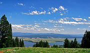
, which extends over 30 miles from Payette Lake
at McCall
south to Cascade
to Round Valley.
The valley was formerly a summer pasture for livestock from the Boise Valley
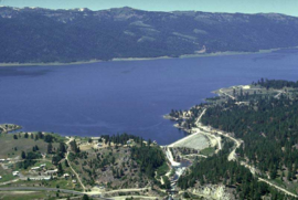
. Since the completion of the Cascade Dam in 1948, much of the northern valley has been covered by the Cascade Reservoir
. The population was 9,862 at the 2010 census. The county seat
is Cascade
, and the largest city is McCall
.
Valley County is home to the Idaho ground squirrel
.
The county's primary highway is the north-south State Highway 55
, the Payette River Scenic Byway, a designated national scenic byway
. It heads north from Eagle
in Ada County
to Horseshoe Bend
in Boise County
, and climbs the whitewater
of the Payette River
to Cascade
and McCall
. The route turns west at Payette Lake in McCall and ends at New Meadows
in Adams County
, at the junction with US-95
.
defeated Barack Obama
by only 7% (52-45%).
of 2000, there were 7,651 people, 3,208 households, and 2,252 families residing in the county. The population density
was 2 people per square mile (1/km²). There were 8,084 housing units at an average density of 2 per square mile (1/km²). The racial makeup of the county was 96.43% White
, 0.69% Native American
, 0.30% Asian
, 0.04% Black
or African American
, 0.04% Pacific Islander
, 1.10% from other races
, and 1.40% from two or more races. 1.96% of the population were Hispanic
or Latino
of any race. 19.1% were of German
, 16.4% English
, 11.3% American
and 10.1% Irish
ancestry according to Census 2000.
There were 3208 households out of which 28.10% had children under the age of 18 living with them, 60.90% were married couples
living together, 5.40% had a female householder with no husband present, and 29.80% were non-families. 24.80% of all households were made up of individuals and 7.90% had someone living alone who was 65 years of age or older. The average household size was 2.36 and the average family size was 2.81.
In the county the population was spread out with 23.70% under the age of 18, 4.40% from 18 to 24, 24.90% from 25 to 44, 32.20% from 45 to 64, and 14.80% who were 65 years of age or older. The median age was 44 years. For every 100 females there were 105.90 males. For every 100 females age 18 and over, there were 104.40 males.
The median income for a household in the county was $36,927, and the median income for a family was $42,283. Males had a median income of $31,113 versus $21,777 for females. The per capita income
for the county was $19,246. About 6.20% of families and 9.30% of the population were below the poverty line, including 10.10% of those under age 18 and 5.60% of those age 65 or over.
Idaho
Idaho is a state in the Rocky Mountain area of the United States. The state's largest city and capital is Boise. Residents are called "Idahoans". Idaho was admitted to the Union on July 3, 1890, as the 43rd state....
in the United States
United States
The United States of America is a federal constitutional republic comprising fifty states and a federal district...
. Established in 1917, it was named after the Long Valley of the North Fork of the Payette River
Payette River
The Payette River is an river in southwestern Idaho and is a major tributary of the Snake River.Its headwaters originate in the Sawtooth and Salmon River Mountains at elevations over...
, which extends over 30 miles from Payette Lake
Payette
Payette is the name of a town, county, river system, three lakes, mountain, and a national forest in the U.S. state of Idaho.They are named for Francois Payette *Payette, Idaho*Payette County, Idaho...
at McCall
McCall, Idaho
McCall is a resort town on the western edge of Valley County, Idaho, United States. Named after its founder, Tom McCall, it is situated on the southern shore of Payette Lake, near the center of the Payette National Forest...
south to Cascade
Cascade, Idaho
Cascade is a rural city in and the county seat of Valley County, Idaho, United States, in the west central part of the state. It sits at an elevation of , along the North Fork of the Payette River...
to Round Valley.
The valley was formerly a summer pasture for livestock from the Boise Valley
Treasure Valley
The Treasure Valley is the area of the Western United States where the Payette, Boise, Weiser, Malheur, Owyhee, and Burnt rivers drain into the Snake River. Treasure Valley includes all the lowland areas from Vale, Oregon on the west to Boise, Idaho on the east. Formerly, the valley had been known...
. Since the completion of the Cascade Dam in 1948, much of the northern valley has been covered by the Cascade Reservoir
Lake Cascade
Lake Cascade is located on the North Fork of the Payette River in Valley County, Idaho, USA, in the Boise National Forest. It is the fourth largest lake or reservoir in the state...
. The population was 9,862 at the 2010 census. The county seat
County seat
A county seat is an administrative center, or seat of government, for a county or civil parish. The term is primarily used in the United States....
is Cascade
Cascade, Idaho
Cascade is a rural city in and the county seat of Valley County, Idaho, United States, in the west central part of the state. It sits at an elevation of , along the North Fork of the Payette River...
, and the largest city is McCall
McCall, Idaho
McCall is a resort town on the western edge of Valley County, Idaho, United States. Named after its founder, Tom McCall, it is situated on the southern shore of Payette Lake, near the center of the Payette National Forest...
.
Valley County is home to the Idaho ground squirrel
Idaho Ground Squirrel
The Idaho ground squirrel is a species of the largest genus of ground squirrels. There are two subspecies, both in Idaho. They are also known as Idaho Spotted Ground Squirrel.-Description:...
.
Geography
According to the 2000 census, the county has a total area of 3733.66 square miles (9,670.1 km²), of which 3677.82 square miles (9,525.5 km²) (or 98.50%) is land and 55.84 square miles (144.6 km²) (or 1.50%) is water.Adjacent counties
- Idaho CountyIdaho County, IdahoIdaho County is a county located in the U.S. state of Idaho. As of the 2010 Census the county had a population of 16,267. The county seat is Grangeville...
- north - Adams CountyAdams County, IdahoAdams County is a rural county located in the state of Idaho. As of the 2010 census the county had a population of 3,976. The county seat and largest city is Council.Adams County was established in 1911 and was named in honor of President John Adams...
- west - Gem CountyGem County, IdahoGem County is a county in the U.S. state of Idaho. The population was 15,181 at the 2000 census; it was estimated at 16,496 in 2007. The county seat is Emmett.Gem County is home to the Idaho ground squirrel....
- southwest - Boise CountyBoise County, IdahoBoise County is a rural mountain county in the U.S. state of Idaho. The population was 6,670 at the 2000 census; it was estimated at 7,571 in 2007...
- south - Custer CountyCuster County, IdahoCuster County is a rural mountain county located in the center of the U.S. state of Idaho. Established in 1881, it was named for the General Custer Mine, where gold was discovered five years earlier . The population was 4,342 at the 2000 census; it is estimated to have fallen to 4,166 by 2007...
- east - Lemhi CountyLemhi County, IdahoLemhi County is a county located in the U.S. state of Idaho. The county was established in 1869, named after Fort Lemhi , a remote Mormon missionary settlement from 1855-58 in Bannock and Shoshone territory. As of the 2000 Census the county had a population of 7,806...
- east
National protected areas
- Boise National ForestBoise National ForestThe Boise National Forest is a US national forest located north and east of the city of Boise, Idaho. It is about 2,612,000 acres in size, ranging in elevation from 2,600 to 9,800 feet . The mountainous landscape developed through uplifting, faulting, and stream cutting...
(part) - Payette National ForestPayette National ForestThe Payette National Forest, is a U.S. National Forest located in central western Idaho, in parts of Valley, Idaho, Adams, and Washington counties. The land area consists of approximately 2.3 million acres of federally managed lands...
(part) - Salmon National Forest (part)
Highways
- Payette River Scenic BywayThe county's primary highway is the north-south State Highway 55
Idaho State Highway 55
State Highway 55 is an Idaho highway from Marsing to New Meadows, connecting with US-95 at both ends.From Marsing it travels east to Nampa, Meridian, and Eagle, then north to Horseshoe Bend. SH-55 then climbs the Payette River to Banks, then its north fork to the Long Valley, through the towns of...
, the Payette River Scenic Byway, a designated national scenic byway
National Scenic Byway
A National Scenic Byway is a road recognized by the United States Department of Transportation for its archeological, cultural, historic, natural, recreational, and/or scenic qualities. The program was established by Congress in 1991 to preserve and protect the nation's scenic but often...
. It heads north from Eagle
Eagle, Idaho
Eagle is a city in Ada County, Idaho, United States. The population was 19,908 at the 2010 census. Due to growth in the Boise metropolitan area, Eagle has become increasingly suburban in recent years.-Geography:...
in Ada County
Ada County, Idaho
Ada County is a county in the southwestern part of the U.S. state of Idaho. As of the 2010 Census, the county had a population of 392,365. The county seat and largest city is Boise, which is also the state capital. Other cities in the county with over 10,000 residents include Meridian, Eagle,...
to Horseshoe Bend
Horseshoe Bend, Idaho
Horseshoe Bend is the largest city in rural Boise County, in the southwestern part of the U.S. state of Idaho. Its population of 770 at the 2000 census was the largest in the county. It is part of the Boise City–Nampa, Idaho Metropolitan Statistical Area...
in Boise County
Boise County, Idaho
Boise County is a rural mountain county in the U.S. state of Idaho. The population was 6,670 at the 2000 census; it was estimated at 7,571 in 2007...
, and climbs the whitewater
Whitewater
Whitewater is formed in a rapid, when a river's gradient increases enough to disturb its laminar flow and create turbulence, i.e. form a bubbly, or aerated and unstable current; the frothy water appears white...
of the Payette River
Payette River
The Payette River is an river in southwestern Idaho and is a major tributary of the Snake River.Its headwaters originate in the Sawtooth and Salmon River Mountains at elevations over...
to Cascade
Cascade, Idaho
Cascade is a rural city in and the county seat of Valley County, Idaho, United States, in the west central part of the state. It sits at an elevation of , along the North Fork of the Payette River...
and McCall
McCall, Idaho
McCall is a resort town on the western edge of Valley County, Idaho, United States. Named after its founder, Tom McCall, it is situated on the southern shore of Payette Lake, near the center of the Payette National Forest...
. The route turns west at Payette Lake in McCall and ends at New Meadows
New Meadows, Idaho
New Meadows is a rural city in Adams County, Idaho, United States, at the southern and upper end of the Meadows Valley, on the Little Salmon River. Located in the west central part of the state, just south of the 45th parallel north, the population was 496 at the 2010 census. New Meadows is...
in Adams County
Adams County, Idaho
Adams County is a rural county located in the state of Idaho. As of the 2010 census the county had a population of 3,976. The county seat and largest city is Council.Adams County was established in 1911 and was named in honor of President John Adams...
, at the junction with US-95
U.S. Route 95 in Idaho
In the U.S. state of Idaho, U.S. Route 95 is a north–south highway near the western border of the state, stretching from Oregon to British Columbia for over .-Route description:...
.
Airports
The county has public-use airports owned by the state, by the U.S. Forest Service, and by local municipalities.- Bernard USFS Airport (U54)
- Big Creek AirportBig Creek Airport (Idaho)Big Creek Airport is a state-owned public-use airstrip in Valley County, Idaho, United States. It is located 12 nautical miles northeast of Yellow Pine, Idaho and 17 nautical miles west of the Cabin Creek USFS Airport ....
(U60) - Bruce Meadows Airport (U63)
- Cabin Creek USFS AirportCabin Creek USFS AirportCabin Creek USFS Airport is a public-use airport in Valley County, Idaho, United States. It is located 17 nautical miles east of Big Creek Ranger Station. The airport owned by the U.S. Forest Service...
(I08) - Cascade Airport (U70)
- Donald D. Coski Memorial Airport (U84)
- Indian Creek USFS AirportIndian Creek USFS AirportIndian Creek USFS Airport is a public use airport located at Indian Creek in Valley County, Idaho, United States. It is owned by the U.S. Forest Service. The airstrip is situated next to the Middle Fork Salmon River.- Facilities and aircraft :...
(S81) - Johnson Creek AirportJohnson Creek AirportJohnson Creek Airport is a grass airstrip located in Central Idaho three miles south of Yellow Pine, a village in Valley County, Idaho, United States. It is managed by the Idaho Division of Aeronautics of the Idaho Transportation Department. A caretaker resides at the field, and as a result, the...
(3U2) - Krassel USFS Airport (24K)
- Landmark USFS Airport (0U0)
- Mahoney Creek USFS Airport (0U3)
- McCall Municipal AirportMcCall Municipal AirportMcCall Municipal Airport is a city-owned public-use airport located in McCall, a city in Valley County, Idaho, United States. It is included in the FAA's National Plan of Integrated Airport Systems for 2011–2015, which categorized it as a general aviation facility.It is home to a U.S...
(MYL) - Soldier Bar USFS Airport (85U)
- Thomas Creek Airport (2U8)
Government and politics
Valley County has long been a Republican stronghold, like most of Idaho. In 2004 George Bush defeated John Kerry by a 21% margin (59-38%). In 2008 Valley County was much more competitive than in recent years, as John McCainJohn McCain
John Sidney McCain III is the senior United States Senator from Arizona. He was the Republican nominee for president in the 2008 United States election....
defeated Barack Obama
Barack Obama
Barack Hussein Obama II is the 44th and current President of the United States. He is the first African American to hold the office. Obama previously served as a United States Senator from Illinois, from January 2005 until he resigned following his victory in the 2008 presidential election.Born in...
by only 7% (52-45%).
Demographics
As of the censusCensus
A census is the procedure of systematically acquiring and recording information about the members of a given population. It is a regularly occurring and official count of a particular population. The term is used mostly in connection with national population and housing censuses; other common...
of 2000, there were 7,651 people, 3,208 households, and 2,252 families residing in the county. The population density
Population density
Population density is a measurement of population per unit area or unit volume. It is frequently applied to living organisms, and particularly to humans...
was 2 people per square mile (1/km²). There were 8,084 housing units at an average density of 2 per square mile (1/km²). The racial makeup of the county was 96.43% White
Race (United States Census)
Race and ethnicity in the United States Census, as defined by the Federal Office of Management and Budget and the United States Census Bureau, are self-identification data items in which residents choose the race or races with which they most closely identify, and indicate whether or not they are...
, 0.69% Native American
Race (United States Census)
Race and ethnicity in the United States Census, as defined by the Federal Office of Management and Budget and the United States Census Bureau, are self-identification data items in which residents choose the race or races with which they most closely identify, and indicate whether or not they are...
, 0.30% Asian
Race (United States Census)
Race and ethnicity in the United States Census, as defined by the Federal Office of Management and Budget and the United States Census Bureau, are self-identification data items in which residents choose the race or races with which they most closely identify, and indicate whether or not they are...
, 0.04% Black
Race (United States Census)
Race and ethnicity in the United States Census, as defined by the Federal Office of Management and Budget and the United States Census Bureau, are self-identification data items in which residents choose the race or races with which they most closely identify, and indicate whether or not they are...
or African American
Race (United States Census)
Race and ethnicity in the United States Census, as defined by the Federal Office of Management and Budget and the United States Census Bureau, are self-identification data items in which residents choose the race or races with which they most closely identify, and indicate whether or not they are...
, 0.04% Pacific Islander
Race (United States Census)
Race and ethnicity in the United States Census, as defined by the Federal Office of Management and Budget and the United States Census Bureau, are self-identification data items in which residents choose the race or races with which they most closely identify, and indicate whether or not they are...
, 1.10% from other races
Race (United States Census)
Race and ethnicity in the United States Census, as defined by the Federal Office of Management and Budget and the United States Census Bureau, are self-identification data items in which residents choose the race or races with which they most closely identify, and indicate whether or not they are...
, and 1.40% from two or more races. 1.96% of the population were Hispanic
Race (United States Census)
Race and ethnicity in the United States Census, as defined by the Federal Office of Management and Budget and the United States Census Bureau, are self-identification data items in which residents choose the race or races with which they most closely identify, and indicate whether or not they are...
or Latino
Race (United States Census)
Race and ethnicity in the United States Census, as defined by the Federal Office of Management and Budget and the United States Census Bureau, are self-identification data items in which residents choose the race or races with which they most closely identify, and indicate whether or not they are...
of any race. 19.1% were of German
Germans
The Germans are a Germanic ethnic group native to Central Europe. The English term Germans has referred to the German-speaking population of the Holy Roman Empire since the Late Middle Ages....
, 16.4% English
English people
The English are a nation and ethnic group native to England, who speak English. The English identity is of early mediaeval origin, when they were known in Old English as the Anglecynn. England is now a country of the United Kingdom, and the majority of English people in England are British Citizens...
, 11.3% American
United States
The United States of America is a federal constitutional republic comprising fifty states and a federal district...
and 10.1% Irish
Irish people
The Irish people are an ethnic group who originate in Ireland, an island in northwestern Europe. Ireland has been populated for around 9,000 years , with the Irish people's earliest ancestors recorded having legends of being descended from groups such as the Nemedians, Fomorians, Fir Bolg, Tuatha...
ancestry according to Census 2000.
There were 3208 households out of which 28.10% had children under the age of 18 living with them, 60.90% were married couples
Marriage
Marriage is a social union or legal contract between people that creates kinship. It is an institution in which interpersonal relationships, usually intimate and sexual, are acknowledged in a variety of ways, depending on the culture or subculture in which it is found...
living together, 5.40% had a female householder with no husband present, and 29.80% were non-families. 24.80% of all households were made up of individuals and 7.90% had someone living alone who was 65 years of age or older. The average household size was 2.36 and the average family size was 2.81.
In the county the population was spread out with 23.70% under the age of 18, 4.40% from 18 to 24, 24.90% from 25 to 44, 32.20% from 45 to 64, and 14.80% who were 65 years of age or older. The median age was 44 years. For every 100 females there were 105.90 males. For every 100 females age 18 and over, there were 104.40 males.
The median income for a household in the county was $36,927, and the median income for a family was $42,283. Males had a median income of $31,113 versus $21,777 for females. The per capita income
Per capita income
Per capita income or income per person is a measure of mean income within an economic aggregate, such as a country or city. It is calculated by taking a measure of all sources of income in the aggregate and dividing it by the total population...
for the county was $19,246. About 6.20% of families and 9.30% of the population were below the poverty line, including 10.10% of those under age 18 and 5.60% of those age 65 or over.
Communities
Unincorporated communities
- Big Creek
- Lake Fork
- Roseberry
- Smiths Ferry
- Warm Lake
- Yellow PineYellow Pine, IdahoYellow Pine is an unincorporated census-designated place in Valley County, Idaho, United States. As of the 2010 census, its population was 32. Yellow Pine has an area of ; of this is land, and is water....