

Pacaha
Encyclopedia
Hernando de Soto (explorer)
Hernando de Soto was a Spanish explorer and conquistador who, while leading the first European expedition deep into the territory of the modern-day United States, was the first European documented to have crossed the Mississippi River....
expedition. This tribe inhabited fortified villages in what is today the northeastern portion of the U.S. state
U.S. state
A U.S. state is any one of the 50 federated states of the United States of America that share sovereignty with the federal government. Because of this shared sovereignty, an American is a citizen both of the federal entity and of his or her state of domicile. Four states use the official title of...
of Arkansas
Arkansas
Arkansas is a state located in the southern region of the United States. Its name is an Algonquian name of the Quapaw Indians. Arkansas shares borders with six states , and its eastern border is largely defined by the Mississippi River...
.
The tribe takes its name from the chieftain Pacaha (born in early 16th century), who ruled the tribe from its primary village on the Mississippi River
Mississippi River
The Mississippi River is the largest river system in North America. Flowing entirely in the United States, this river rises in western Minnesota and meanders slowly southwards for to the Mississippi River Delta at the Gulf of Mexico. With its many tributaries, the Mississippi's watershed drains...
, which was thought to be located in present-day Crittenden County, Arkansas near Turrell
Turrell, Arkansas
Turrell is a city in Crittenden County, Arkansas, United States. The population was 957 at the 2000 census.-Geography:Turrell's area of location is positioned primarily next to the item of liquid substance at the map coordinate ....
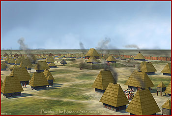
. The site, part of the Nodena Phase
Nodena Phase
The Nodena Phase is an archaeological phase in eastern Arkansas and southeastern Missouri of the Late Mississippian culture which dates from about 1400–1650 CE. The Nodena Phase is known from a collection of villages along the Mississippi River between the Missouri Bootheel and Wapanocca Lake...
, is known to archaeologists as "The Bradley Site". Information about Chief Pacaha and his people comes from journals made during the expedition of Hernando De Soto in 1541. The de Soto expedition stayed at Pacaha's village for approximately 40 days.
De Soto Expedition
The initial encounter between the Pacaha and the de Soto expedition was violent. Chief Pacaha's tribe had been at war for some time with a neighboring chieftain named CasquiCasqui
Casqui was a Native American tribe discovered in 1541 by the Hernando de Soto expedition. This tribe inhabited fortified villages in eastern Arkansas....
. The Casqui tribe is thought to have lived at a site near Parkin, Arkansas
Parkin, Arkansas
Parkin is a city in Cross County, Arkansas, in the United States, along the St. Francis River. The population was 1,602 at the 2000 census.-Geography:Parkin is located at ....
and the location of the present-day Parkin Archeological State Park
Parkin Archeological State Park
Parkin Archeological State Park, also known as Parkin Indian Mound, is an archeological site and state park in Parkin, Cross County, Arkansas. Around 1350–1650 CE an aboriginal palisaded village existed at the site, at the confluence of the St. Francis and Tyronza Rivers. Artifacts from this...
.
Casqui
Casqui was a Native American tribe discovered in 1541 by the Hernando de Soto expedition. This tribe inhabited fortified villages in eastern Arkansas....
tribe first. When he pressed on to visit the Pacaha village, many of the Casqui people followed him. Many of the Pacaha, seeing the approach of their enemy, attempted to flee to an island in the river and drowned. The Casqui who accompanied de Soto sacked the village, desecrated holy sites, and looted valuables.
The Pacaha controlled more territory and had a larger population than the Casqui. Chief Pacaha was younger than the Casqui chief, however, and seemingly had more to lose from the continued aggressive Casqui attacks. De Soto contacted Chief Pacaha and convinced him that he had nothing to do with the attack and that the expedition's intentions were peaceful. De Soto assured the Pacaha that the expedition would help the Pacaha attack the Casqui to punish them for their subterfuge.
The Casqui received advance warning of the planned attack. They returned the looted items and apologized in order to stave off retribution. De Soto arranged a dinner for the two leaders and a peace treaty between the tribes. Chief Pacaha presented de Soto with one of his wives, one of his sisters, and another woman from his tribe. This action was in gratitude for the arrangement of peace and also to outdo his rival, who had only presented a daughter to de Soto.
The Hernando de Soto expedition records are the only historical records of Chief Pacaha and his tribe. Their later history is uncertain.
The name Pacaha was spelled Capaha in one account. Some scholars believe this word is related to the historic Quapaw
Quapaw
The Quapaw people are a tribe of Native Americans who historically resided on the west side of the Mississippi River in what is now the state of Arkansas.They are federally recognized as the Quapaw Tribe of Indians.-Government:...
tribe encountered in Arkansas by European expeditions in the 17th and 18th centuries. The primary village of the eastern Arkansas Quapaw was named Kappa or Kappah. Human and cultural remains found at the suspected Pacaha site are repatriated to the Quapaw and Tunica-Biloxi
Tunica-Biloxi
The modern Tunica-Biloxi tribe live in Mississippi and east central Louisiana. The modern tribe is composed of descendants of Tunica, Biloxi , Ofo , Avoyel , and Muskogean Choctaw. They speak mostly English and French...
tribes, which are active.
Controversy
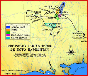
The accepted path of de Soto's travels was established by the research of the de Soto Commission in 1939 led by Dr. John R. SwantonJohn R. Swanton
John Reed Swanton was an American anthropologist and linguist who worked with Native American peoples throughout the United States. Swanton achieved recognition in the fields of ethnology and ethnohistory...
. It has been generally accepted by the United States government and most archaeologists as the historic route. Some critics claim that de Soto traveled north into the states of Indiana
Indiana
Indiana is a US state, admitted to the United States as the 19th on December 11, 1816. It is located in the Midwestern United States and Great Lakes Region. With 6,483,802 residents, the state is ranked 15th in population and 16th in population density. Indiana is ranked 38th in land area and is...
and Illinois
Illinois
Illinois is the fifth-most populous state of the United States of America, and is often noted for being a microcosm of the entire country. With Chicago in the northeast, small industrial cities and great agricultural productivity in central and northern Illinois, and natural resources like coal,...
and found the Ohio River
Ohio River
The Ohio River is the largest tributary, by volume, of the Mississippi River. At the confluence, the Ohio is even bigger than the Mississippi and, thus, is hydrologically the main stream of the whole river system, including the Allegheny River further upstream...
instead of the Mississippi River
Mississippi River
The Mississippi River is the largest river system in North America. Flowing entirely in the United States, this river rises in western Minnesota and meanders slowly southwards for to the Mississippi River Delta at the Gulf of Mexico. With its many tributaries, the Mississippi's watershed drains...
.
Due to this controversy, some claim that the town of Pacaha was located on the present-day site of Terre Haute, Indiana
Terre Haute, Indiana
Terre Haute is a city and the county seat of Vigo County, Indiana, United States, near the state's western border with Illinois. As of the 2010 census, the city had a total population of 60,785 and its metropolitan area had a population of 170,943. The city is the county seat of Vigo County and...
, and their enemies the Casqui being located near present-day Vincennes
Vincennes, Indiana
Vincennes is a city in and the county seat of Knox County, Indiana, United States. It is located on the Wabash River in the southwestern part of the state. The population was 18,701 at the 2000 census...
. This route is not the officially accepted route, but archaeological study and analysis continues.
See also
- List of sites and peoples visited by the Hernando de Soto Expedition
- CasquiCasquiCasqui was a Native American tribe discovered in 1541 by the Hernando de Soto expedition. This tribe inhabited fortified villages in eastern Arkansas....
- Parkin Archeological State ParkParkin Archeological State ParkParkin Archeological State Park, also known as Parkin Indian Mound, is an archeological site and state park in Parkin, Cross County, Arkansas. Around 1350–1650 CE an aboriginal palisaded village existed at the site, at the confluence of the St. Francis and Tyronza Rivers. Artifacts from this...
- Nodena SiteNodena SiteThe Nodena Site is an archeological site east of Wilson, Arkansas and northeast of Reverie, Tennessee in Mississippi County, Arkansas, United States. Around 1400–1650 CE an aboriginal palisaded village existed in the Nodena area on a meander bend of the Mississippi River. The Nodena site...
- Mississippian cultureMississippian cultureThe Mississippian culture was a mound-building Native American culture that flourished in what is now the Midwestern, Eastern, and Southeastern United States from approximately 800 CE to 1500 CE, varying regionally....
- Southeastern Ceremonial ComplexSoutheastern Ceremonial ComplexThe Southeastern Ceremonial Complex is the name given to the regional stylistic similarity of artifacts, iconography, ceremonies, and mythology of the Mississippian culture that coincided with their adoption of maize agriculture and chiefdom-level complex social organization from...