

Crittenden County, Arkansas
Encyclopedia
Crittenden County is a county
located in the U.S. state
of Arkansas
. As of the 2010 census
, the population was 50,902. The county seat
is Marion
, while its largest city is West Memphis
. Crittenden County is Arkansas's twelfth county, formed on October 22, 1825, and named for Robert Crittenden
, the first Secretary of the Arkansas Territory
. Crittenden County was the site of the 1993 murders that led to the possibly wrongful conviction of the West Memphis Three
, although the trial was moved to neighboring Craighead County
.
Crittenden County is part of the Memphis
, TN
–MS
–AR
Metropolitan Statistical Area
.
 As of the census
of 2000, there were 50,866 people, 18,471 households, and 13,373 families residing in the county. The population density
was 83 people per square mile (32/km²). There were 20,507 housing units at an average density of 34 per square mile (13/km²). The racial makeup of the county was 50.91% White
, 47.05% Black
or African American
, 0.24% Native American
, 0.47% Asian
, 0.02% Pacific Islander
, 0.66% from other races
, and 0.64% from two or more races. 1.42% of the population were Hispanic
or Latino
of any race.
There were 18,471 households out of which 37.40% had children under the age of 18 living with them, 45.80% were married couples
living together, 21.30% had a female householder with no husband present, and 27.60% were non-families. 23.70% of all households were made up of individuals and 8.00% had someone living alone who was 65 years of age or older. The average household size was 2.72 and the average family size was 3.23.
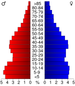
In the county the population was spread out with 31.10% under the age of 18, 9.40% from 18 to 24, 29.10% from 25 to 44, 20.50% from 45 to 64, and 9.90% who were 65 years of age or older. The median age was 32 years. For every 100 females there were 91.00 males. For every 100 females age 18 and over, there were 85.00 males.
The median income for a household in the county was $30,109, and the median income for a family was $34,982. Males had a median income of $31,299 versus $21,783 for females. The per capita income
for the county was $14,424. About 21.00% of families and 25.30% of the population were below the poverty line, including 35.30% of those under age 18 and 23.70% of those age 65 or over.
County (United States)
In the United States, a county is a geographic subdivision of a state , usually assigned some governmental authority. The term "county" is used in 48 of the 50 states; Louisiana is divided into parishes and Alaska into boroughs. Parishes and boroughs are called "county-equivalents" by the U.S...
located in the U.S. state
U.S. state
A U.S. state is any one of the 50 federated states of the United States of America that share sovereignty with the federal government. Because of this shared sovereignty, an American is a citizen both of the federal entity and of his or her state of domicile. Four states use the official title of...
of Arkansas
Arkansas
Arkansas is a state located in the southern region of the United States. Its name is an Algonquian name of the Quapaw Indians. Arkansas shares borders with six states , and its eastern border is largely defined by the Mississippi River...
. As of the 2010 census
United States Census, 2010
The Twenty-third United States Census, known as Census 2010 or the 2010 Census, is the current national census of the United States. National Census Day was April 1, 2010 and is the reference date used in enumerating individuals...
, the population was 50,902. The county seat
County seat
A county seat is an administrative center, or seat of government, for a county or civil parish. The term is primarily used in the United States....
is Marion
Marion, Arkansas
Marion is a city in Crittenden County, Arkansas, United States. The population was 8,901 at the 2000 census. The city is the county seat of Crittenden County, and is part of the Memphis metropolitan area...
, while its largest city is West Memphis
West Memphis, Arkansas
West Memphis is the largest city in Crittenden County, Arkansas, United States. The population was 27,666 at the 2000 census, with an estimated population of 28,181 in 2005, and 31,329 in 2011 ranking it as the state's 11th largest city, behind Hot Springs...
. Crittenden County is Arkansas's twelfth county, formed on October 22, 1825, and named for Robert Crittenden
Robert Crittenden
Robert Crittenden was Governor of Arkansas Territory and co-founder of Rose Law Firm. Robert Crittenden was born near Versailles, Kentucky....
, the first Secretary of the Arkansas Territory
Arkansas Territory
The Territory of Arkansas, initially organized as the Territory of Arkansaw, was an organized incorporated territory of the United States that existed from July 4, 1819 until June 15, 1836, when the final extent of the territory was admitted to the Union as the State of Arkansas.-History:The...
. Crittenden County was the site of the 1993 murders that led to the possibly wrongful conviction of the West Memphis Three
West Memphis Three
The West Memphis Three are three men who were tried and convicted as teenagers in 1994 of the 1993 murders of three boys in West Memphis, Arkansas. Damien Echols was sentenced to death, Jessie Misskelley, Jr. was sentenced to life imprisonment plus two 20-year sentences, and Jason Baldwin was...
, although the trial was moved to neighboring Craighead County
Craighead County, Arkansas
Craighead County is a county located in the U.S. state of Arkansas. As of the 2010 census, the population was 96,443. It is included in the Jonesboro, Arkansas Metropolitan Statistical Area. Craighead County is Arkansas's 58th county, formed on February 19, 1859, and named for state Senator Thomas...
.
Crittenden County is part of the Memphis
Memphis, Tennessee
Memphis is a city in the southwestern corner of the U.S. state of Tennessee, and the county seat of Shelby County. The city is located on the 4th Chickasaw Bluff, south of the confluence of the Wolf and Mississippi rivers....
, TN
Tennessee
Tennessee is a U.S. state located in the Southeastern United States. It has a population of 6,346,105, making it the nation's 17th-largest state by population, and covers , making it the 36th-largest by total land area...
–MS
Mississippi
Mississippi is a U.S. state located in the Southern United States. Jackson is the state capital and largest city. The name of the state derives from the Mississippi River, which flows along its western boundary, whose name comes from the Ojibwe word misi-ziibi...
–AR
Arkansas
Arkansas is a state located in the southern region of the United States. Its name is an Algonquian name of the Quapaw Indians. Arkansas shares borders with six states , and its eastern border is largely defined by the Mississippi River...
Metropolitan Statistical Area
Memphis Metropolitan Area
The Memphis Metropolitan Statistical Area, TN-MS-AR , more commonly known as The Mid-South, is the 41st largest among similarly designated areas in the United States. The metropolitan area covers eight counties in three states – Tennessee, Mississippi, and Arkansas...
.
Geography
According to the 2000 census, the county has a total area of 636.69 square miles (1,649 km²), of which 610.17 square miles (1,580.3 km²) (or 95.83%) is land and 26.52 square miles (68.7 km²) (or 4.17%) is water.Major Highways
|
 Highway 38 Highway 38 Highway 42 Highway 42 Highway 50 Highway 50 Highway 77 Highway 77 Highway 118 Highway 118Arkansas Highway 118 Arkansas Highway 118 is a long state highway in Eastern Arkansas. It contains no spur or business routes.-Route description:Arkansas Highway 118 begins at US 70/US 79 in West Memphis and heads north to meet Interstate 40 before hitting US 64 and angling east by Crawfordsville and Earle. Heading...  Highway 131 Highway 131Arkansas Highway 131 -Haynes to Lee 719:Highway 131 is an east–west highway in Arkansas. It runs from AR 1 in Haynes east to Lee County Road 719.-Horseshoe Lake:Highway 131 is a highway in Arkansas. It runs from AR 147 around Horseshoe Lake and meets AR 147....  Highway 147 Highway 147 |
 Highway 149 Highway 149 Highway 191 Highway 191Arkansas Highway 191 Arkansas Highway 191 is a state highway located entirely within West Memphis, Crittenden County, Arkansas. The highway runs from U.S. Route 70 north to Arkansas Highway 77. The highway is maintained by the Arkansas State Highway and Transportation Department....  Highway 218 Highway 218Arkansas Highway 218 Arkansas Highway 218 is an east–west state highway in Crittenden County, Arkansas. The route of runs from US Route 70 and US 79 at Shearerville north across Interstate 40 through rural Crittenden County to Highway 147 at Cunningham Corner.-Route description:Highway 218 begins at... |
 U.S. Highway 61
 U.S. Highway 63
 U.S. Highway 64
 U.S. Highway 70
 U.S. Highway 79
Adjacent counties
- Mississippi County (northeast)
- Tipton County, TennesseeTipton County, TennesseeTipton County is a county located on the western end of the U.S. state of Tennessee. As of 2000, the population was 51,271. Its county seat is Covington. Tipton County is part of the Memphis, TN–MS–AR Metropolitan Statistical Area, centered on Shelby County, which borders Tipton on...
& Shelby County, TennesseeShelby County, TennesseeShelby County is a county located in the U.S. state of Tennessee. It is the state's largest both in terms of population and geographic area, with a population of 927,644 at the 2010 census...
(east) - DeSoto County, MississippiDeSoto County, Mississippi-Demographics:As of the census of 2005 estimate, there were 137,004 people, 38,792 households, and 30,102 families residing in the county. The population density was 224 people per square mile . There were 40,795 housing units at an average density of 85 per square mile...
(southeast) - Tunica County, MississippiTunica County, MississippiAs of the census of 2000, there were 9,227 people, 3,258 households, and 2,192 families residing in the county. The population density was 20 people per square mile . There were 3,705 housing units at an average density of 8 per square mile...
(south) - Lee County (southwest)
- St. Francis County & Cross County (west)
- Poinsett County (northwest)
Demographics
Census
A census is the procedure of systematically acquiring and recording information about the members of a given population. It is a regularly occurring and official count of a particular population. The term is used mostly in connection with national population and housing censuses; other common...
of 2000, there were 50,866 people, 18,471 households, and 13,373 families residing in the county. The population density
Population density
Population density is a measurement of population per unit area or unit volume. It is frequently applied to living organisms, and particularly to humans...
was 83 people per square mile (32/km²). There were 20,507 housing units at an average density of 34 per square mile (13/km²). The racial makeup of the county was 50.91% White
Race (United States Census)
Race and ethnicity in the United States Census, as defined by the Federal Office of Management and Budget and the United States Census Bureau, are self-identification data items in which residents choose the race or races with which they most closely identify, and indicate whether or not they are...
, 47.05% Black
Race (United States Census)
Race and ethnicity in the United States Census, as defined by the Federal Office of Management and Budget and the United States Census Bureau, are self-identification data items in which residents choose the race or races with which they most closely identify, and indicate whether or not they are...
or African American
Race (United States Census)
Race and ethnicity in the United States Census, as defined by the Federal Office of Management and Budget and the United States Census Bureau, are self-identification data items in which residents choose the race or races with which they most closely identify, and indicate whether or not they are...
, 0.24% Native American
Race (United States Census)
Race and ethnicity in the United States Census, as defined by the Federal Office of Management and Budget and the United States Census Bureau, are self-identification data items in which residents choose the race or races with which they most closely identify, and indicate whether or not they are...
, 0.47% Asian
Race (United States Census)
Race and ethnicity in the United States Census, as defined by the Federal Office of Management and Budget and the United States Census Bureau, are self-identification data items in which residents choose the race or races with which they most closely identify, and indicate whether or not they are...
, 0.02% Pacific Islander
Race (United States Census)
Race and ethnicity in the United States Census, as defined by the Federal Office of Management and Budget and the United States Census Bureau, are self-identification data items in which residents choose the race or races with which they most closely identify, and indicate whether or not they are...
, 0.66% from other races
Race (United States Census)
Race and ethnicity in the United States Census, as defined by the Federal Office of Management and Budget and the United States Census Bureau, are self-identification data items in which residents choose the race or races with which they most closely identify, and indicate whether or not they are...
, and 0.64% from two or more races. 1.42% of the population were Hispanic
Race (United States Census)
Race and ethnicity in the United States Census, as defined by the Federal Office of Management and Budget and the United States Census Bureau, are self-identification data items in which residents choose the race or races with which they most closely identify, and indicate whether or not they are...
or Latino
Race (United States Census)
Race and ethnicity in the United States Census, as defined by the Federal Office of Management and Budget and the United States Census Bureau, are self-identification data items in which residents choose the race or races with which they most closely identify, and indicate whether or not they are...
of any race.
There were 18,471 households out of which 37.40% had children under the age of 18 living with them, 45.80% were married couples
Marriage
Marriage is a social union or legal contract between people that creates kinship. It is an institution in which interpersonal relationships, usually intimate and sexual, are acknowledged in a variety of ways, depending on the culture or subculture in which it is found...
living together, 21.30% had a female householder with no husband present, and 27.60% were non-families. 23.70% of all households were made up of individuals and 8.00% had someone living alone who was 65 years of age or older. The average household size was 2.72 and the average family size was 3.23.
In the county the population was spread out with 31.10% under the age of 18, 9.40% from 18 to 24, 29.10% from 25 to 44, 20.50% from 45 to 64, and 9.90% who were 65 years of age or older. The median age was 32 years. For every 100 females there were 91.00 males. For every 100 females age 18 and over, there were 85.00 males.
The median income for a household in the county was $30,109, and the median income for a family was $34,982. Males had a median income of $31,299 versus $21,783 for females. The per capita income
Per capita income
Per capita income or income per person is a measure of mean income within an economic aggregate, such as a country or city. It is calculated by taking a measure of all sources of income in the aggregate and dividing it by the total population...
for the county was $14,424. About 21.00% of families and 25.30% of the population were below the poverty line, including 35.30% of those under age 18 and 23.70% of those age 65 or over.
Cities
Towns
|
Edmondson, Arkansas Edmondson is a town in Crittenden County, Arkansas, United States. The population was 513 at the 2000 census.-Geography:Edmondson is located at .... Gilmore, Arkansas Gilmore is a town in Crittenden County, Arkansas, United States. The population was 292 at the 2000 census.-Geography:Gilmore is located at .... Horseshoe Lake, Arkansas Horseshoe Lake is a town in Crittenden County, Arkansas, United States. The population was 321 at the 2000 census.The town is named after Horseshoe Lake, a horseshoe-shaped lake at the eastern tip of which the town is located.-Geography:... Jennette, Arkansas Jennette is a town in Crittenden County, Arkansas, United States. The population was 124 at the 2000 census.-Geography:Jennette is located at .... |
Jericho, Arkansas Jericho is a town in Crittenden County, Arkansas, United States. The population was 184 at the 2000 census.-Geography:Jericho is located at .According to the United States Census Bureau, the town has a total area of 1.2 km² , all land.... Sunset, Arkansas Sunset is a city in Crittenden County, Arkansas, United States. The population was 348 at the 2000 census.-Geography:Sunset is located at .According to the United States Census Bureau, the city has a total area of , all land.... Turrell, Arkansas Turrell is a city in Crittenden County, Arkansas, United States. The population was 957 at the 2000 census.-Geography:Turrell's area of location is positioned primarily next to the item of liquid substance at the map coordinate .... |
Townships
- Black Oak
- Bob Ward (AnthonyvilleAnthonyville, ArkansasAnthonyville is a town in Crittenden County, Arkansas, United States. The population was 250 at the 2000 census.-Geography:Anthonyville is located at ....
, EdmondsonEdmondson, ArkansasEdmondson is a town in Crittenden County, Arkansas, United States. The population was 513 at the 2000 census.-Geography:Edmondson is located at ....
, small part of JennetteJennette, ArkansasJennette is a town in Crittenden County, Arkansas, United States. The population was 124 at the 2000 census.-Geography:Jennette is located at ....
) - Fogleman (GilmoreGilmore, ArkansasGilmore is a town in Crittenden County, Arkansas, United States. The population was 292 at the 2000 census.-Geography:Gilmore is located at ....
, TurrellTurrell, ArkansasTurrell is a city in Crittenden County, Arkansas, United States. The population was 957 at the 2000 census.-Geography:Turrell's area of location is positioned primarily next to the item of liquid substance at the map coordinate ....
) - Jackson (CrawfordsvilleCrawfordsville, ArkansasCrawfordsville, historically Crawfordville, is a town in Crittenden County, Arkansas, United States. The population was 514 at the 2000 census.Late R&B singer Johnnie Taylor was born in Crawfordsville.-Geography:...
, part of MarionMarion, ArkansasMarion is a city in Crittenden County, Arkansas, United States. The population was 8,901 at the 2000 census. The city is the county seat of Crittenden County, and is part of the Memphis metropolitan area...
, part of West MemphisWest Memphis, ArkansasWest Memphis is the largest city in Crittenden County, Arkansas, United States. The population was 27,666 at the 2000 census, with an estimated population of 28,181 in 2005, and 31,329 in 2011 ranking it as the state's 11th largest city, behind Hot Springs...
small part of JennetteJennette, ArkansasJennette is a town in Crittenden County, Arkansas, United States. The population was 124 at the 2000 census.-Geography:Jennette is located at ....
) - Jasper (SunsetSunset, ArkansasSunset is a city in Crittenden County, Arkansas, United States. The population was 348 at the 2000 census.-Geography:Sunset is located at .According to the United States Census Bureau, the city has a total area of , all land....
, most of MarionMarion, ArkansasMarion is a city in Crittenden County, Arkansas, United States. The population was 8,901 at the 2000 census. The city is the county seat of Crittenden County, and is part of the Memphis metropolitan area...
, part of West MemphisWest Memphis, ArkansasWest Memphis is the largest city in Crittenden County, Arkansas, United States. The population was 27,666 at the 2000 census, with an estimated population of 28,181 in 2005, and 31,329 in 2011 ranking it as the state's 11th largest city, behind Hot Springs...
, small part of ClarkedaleClarkedale, ArkansasClarkedale is a city in Crittenden County, Arkansas, United States. Its population was 371 as of the 2010 census. Clarkedale incorporated on November 15, 2000....
) - Lucas (Horseshoe LakeHorseshoe Lake, ArkansasHorseshoe Lake is a town in Crittenden County, Arkansas, United States. The population was 321 at the 2000 census.The town is named after Horseshoe Lake, a horseshoe-shaped lake at the eastern tip of which the town is located.-Geography:...
) - Mississippi (most of West MemphisWest Memphis, ArkansasWest Memphis is the largest city in Crittenden County, Arkansas, United States. The population was 27,666 at the 2000 census, with an estimated population of 28,181 in 2005, and 31,329 in 2011 ranking it as the state's 11th largest city, behind Hot Springs...
, part of MarionMarion, ArkansasMarion is a city in Crittenden County, Arkansas, United States. The population was 8,901 at the 2000 census. The city is the county seat of Crittenden County, and is part of the Memphis metropolitan area...
) - Mound City (part of MarionMarion, ArkansasMarion is a city in Crittenden County, Arkansas, United States. The population was 8,901 at the 2000 census. The city is the county seat of Crittenden County, and is part of the Memphis metropolitan area...
, part of West MemphisWest Memphis, ArkansasWest Memphis is the largest city in Crittenden County, Arkansas, United States. The population was 27,666 at the 2000 census, with an estimated population of 28,181 in 2005, and 31,329 in 2011 ranking it as the state's 11th largest city, behind Hot Springs...
, small part of ClarkedaleClarkedale, ArkansasClarkedale is a city in Crittenden County, Arkansas, United States. Its population was 371 as of the 2010 census. Clarkedale incorporated on November 15, 2000....
) - Proctor (part of West MemphisWest Memphis, ArkansasWest Memphis is the largest city in Crittenden County, Arkansas, United States. The population was 27,666 at the 2000 census, with an estimated population of 28,181 in 2005, and 31,329 in 2011 ranking it as the state's 11th largest city, behind Hot Springs...
) - Tyronza (EarleEarle, ArkansasEarle is a city in Crittenden County, Arkansas, United States. The population was 3,036 at the 2000 census.-Geography:Earle is located at .According to the United States Census Bureau, the city has a total area of , all land....
, most of JennetteJennette, ArkansasJennette is a town in Crittenden County, Arkansas, United States. The population was 124 at the 2000 census.-Geography:Jennette is located at ....
) - Wappanocca (JerichoJericho, ArkansasJericho is a town in Crittenden County, Arkansas, United States. The population was 184 at the 2000 census.-Geography:Jericho is located at .According to the United States Census Bureau, the town has a total area of 1.2 km² , all land....
, most of ClarkedaleClarkedale, ArkansasClarkedale is a city in Crittenden County, Arkansas, United States. Its population was 371 as of the 2010 census. Clarkedale incorporated on November 15, 2000....
)