

Outer barrier
Encyclopedia
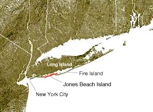
The outer barrier, also known as the Long Island and New York City barrier islands, refers to the string of barrier islands that divide the lagoon
s south of Long Island
from the Atlantic Ocean
.
These islands include Coney Island
, Long Beach Barrier Island
, Jones Beach Island
, Fire Island and Westhampton Island. The outer barrier extends seventy-five miles 120 km along the south shore of Long Island, New York, from Rockaway Beach on the NYC/Nassau County border from Long Beach barrier Islands western edge, to Suffolk County's east end of Shinnecock Bay.
The lagoons enclosed by the barrier islands are Jamaica Bay
, Brosewere Bay, Hewlett Bay, Reynolds Channel
, Middle Bay
, East Bay
, South Oyster Bay
, Great South Bay
, and arms of the Great South Bay that have their own geographic names: Great Cove, Nicoll Bay, Patchogue Bay
, Bellport Bay, Narrow Bay, Moriches Bay
, Quantuck Bay, Tiana Bay, and Shinnecock Bay. East Rockaway Inlet
, Jones Inlet
, Fire Island Inlet
, Moriches Inlet
, and Shinnecock Inlet
pierce the barrier, forming the individual sandy islands. The resort communities of Atlantic Beach
, Long Beach
, and Westhampton Beach; the Fire Island National Seashore
, Robert Moses State Park
, Jones Beach State Park
, and other recreational areas are found there. The low-lying islands are subject to wave erosion, and, during storms, they are sometimes inundated and cut-through.
of Long Island
. The island is shared by the hamlet of Atlantic Beach
to the west, the city of Long Beach
and the hamlet of Lido Beach in the central part of the island, and the hamlet of Point Lookout
at the eastern end of the island. (The three hamlets — Atlantic Beach, Lido Beach, and Point Lookout — are part of the town of Hempstead, New York.)
Within its section of the barrier island, the city of Long Beach spans the entire north-south width of the island, fronting on both Reynolds Channel
, to the north, and the Atlantic Ocean
, to the south. A drawbridge
, the Long Beach Bridge
, connects it to Island Park
on the mainland of Long Island. To the west, the Atlantic Beach Bridge
, connects the island to Lawrence
on Long Island. The Loop Parkway
, located to the east where Lido Beach and Point Lookout
border one another, connects the island to Jones Beach
.
 Jones Beach Island is a barrier island
off the southern coast of Long Island
in the U.S. state
of New York
. It is named for the father of Thomas Jones (historian)
. It is sometimes referred to as Oak Beach Island, and the former home of the infamous Oak Beach Inn
. It is separated from Long Island by Great South Bay
. The island straddles the county line between Nassau
and Suffolk
counties and includes the Census-designated place
of Gilgo-Oak Beach-Captree, New York
.
The southern side of the island is known for its beaches that face the open Atlantic Ocean
. Jones Beach State Park
, on the western tip of the island is a summer recreational destination for the New York City
area.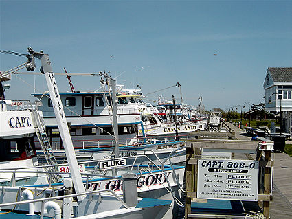 It is accessible from Long Island on its western end by the Meadowbrook Parkway to Merrick, New York
, the Loop Parkway
to Long Beach, New York
and the Wantagh Parkway to Wantagh, New York
. Its eastern end is linked to Babylon, New York
as well as to Fire Island, New York
by the Robert Moses Causeway
via the Great South Bay Bridge
and the State Boat Channel Bridge
. The Ocean Parkway connects all three causeway
s and runs the length of the island, while The Fire Island Inlet Bridge
continues on the Robert Moses Causeway
finding its way to the New York's Fire Island on the Atlantic Ocean
.
, approximately 31 miles (50 km) long and varying between approximately 0.1 mile (160 m) to 0.25 mile (400 m) wide. Fire Island passes through southern Suffolk County, New York
, and is southeast of Long Island
separated from the main land by the Great South Bay
in the U.S. state
of New York
, running approximately SW to NE. The land area is 8.687 sq. mi. (22.5 km2), and a permanent population of 491 people was reported as of the 2000 census
. (There are hundreds of thousands of summertime residents, groupers and daytrippers.) The island is composed of three communities, as defined by the Census Bureau. The largest of these is Fire Island (CDP)
, which is unincorporated and stretches through the southern portion of the towns of Babylon
, Islip
, and Brookhaven
.
There are several ocean front communities such as, Davis Park and Watch Hill
that are on the eastern side of the Great south bay
. Fire Island has a variety of ocean front communities that can be reached by private boat, or seasonal ferry
service from Long Island
's mainland. Fire Island has a 2000 census population of 310 inhabitants. There are also two villages in the Islip section of the island, Saltaire
(pop. 43) and Ocean Beach
(pop. 138). In addition, a part of Fire Island CDP is not even on the island, but on a separate island adjacent to West Hampton Dunes
.
Fire Island Inlet
is an inlet on the south shore of Long Island, New York. It connects the Great South Bay with the Atlantic Ocean
, passing between Robert Moses State Park
(the western end of Fire Island) on the south and Oak Beach and Captree State Park
(the eastern end of Jones Island) on the north. The stated land area and population figures result when this section is subtracted out. The inlet is directly south of West Islip, the nearest town on the main part of Long Island.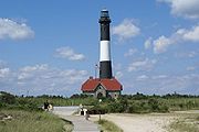 The inlet has evolved over the years due to natural processes, especially longshore drift
. Jones Island and Fire Island at one time were connected. The Fire Island Light was at the mouth of the inlet when built in 1858, but is now six miles east of the inlet. [1]
. The barrier island was part of Fire Island until a Nor'easter in 1931 created Moriches Inlet
and made Fire Island a proper island. In 1938, Shinnecock Inlet
created this fourth barrier island. Cupsogue Beach County Park
is located on the western end of the island.
 Moriches Inlet
is an inlet
connecting Moriches Bay
and the Atlantic Ocean
. The inlet created a geographic oddity whereby the Town of Brookhaven
actually has jurisdiction on land immediately west of the village of West Hampton Dunes
although Brookhaven land access to it involves a nearly 20 mile drive through Southampton.
Shinnecock Inlet
is the easternmost of five major inlets connecting bays to the Atlantic Ocean
through the narrow 100-mile-long barrier islands that stretch from New York City
to Southhampton, New York
on the south shore of Long Island
.
The inlet was formed by the Great Hurricane of 1938 which killed several people when it permanently broke through the island in Hampton Bays, New York
.
The inlet is almost directly lined up with the Shinnecock Canal
between Shinnecock Bay and the Peconic Bay
and saves miles for boaters going to the open Atlantic. Consequently management has been geared to keep the inlet dredged and open. However, maintenance of the inlet has been controversial on grounds that it causes beach erosion on Fire Island.

 Rockaway Inlet
is bound by Brooklyn
to the North and Rockaway Peninsula to the South. It is the entrance to Jamaica Bay
, and most of the inlet is within the boundary of Gateway National Recreation Area
. Its entrance is marked by a light on a jetty extending southward from Breezy Point Tip
.
The entrance channel extends Westward of the jetty and is marked by lighted buoys. It has a depth of about 15 feet midchannel with a shoal
of only one foot.
The Ocean Parkway is a 15.59 miles (25.09 km) long state parkway
that traverses the length of barrier beach
es immediately south of Long Island
, New York
.
The Ocean Parkway begins at the southern terminus of the Meadowbrook State Parkway
, intersects the south end of the Wantagh State Parkway
, and ends just past the southern terminus of the Robert Moses Causeway
. The parkway services a number of parks, including Jones Beach State Park
and Captree State Park
.
It is designated New York State Reference Route 909D, an unsigned reference route.
 Robert Moses Causeway
– Robert Moses State Park
, Fire Island
Robert Moses State Park (Long Island)
is on the western end of Fire Island
, a barrier island
off the southern coast of Long Island
. It is known for its 5 miles (8 km) stretch of splendid beaches on the open Atlantic Ocean
and is a popular summer recreational destination in the New York City
area. The park is accessible from Long Island by the Robert Moses Causeway
across Great South Bay
. This 875 acres (3.5 km²) facility is the oldest state park on Long Island.
Lagoon
A lagoon is a body of shallow sea water or brackish water separated from the sea by some form of barrier. The EU's habitat directive defines lagoons as "expanses of shallow coastal salt water, of varying salinity or water volume, wholly or partially separated from the sea by sand banks or shingle,...
s south of Long Island
Long Island
Long Island is an island located in the southeast part of the U.S. state of New York, just east of Manhattan. Stretching northeast into the Atlantic Ocean, Long Island contains four counties, two of which are boroughs of New York City , and two of which are mainly suburban...
from the Atlantic Ocean
Atlantic Ocean
The Atlantic Ocean is the second-largest of the world's oceanic divisions. With a total area of about , it covers approximately 20% of the Earth's surface and about 26% of its water surface area...
.
These islands include Coney Island
Coney Island
Coney Island is a peninsula and beach on the Atlantic Ocean in southern Brooklyn, New York, United States. The site was formerly an outer barrier island, but became partially connected to the mainland by landfill....
, Long Beach Barrier Island
Long Beach Barrier Island
Long Beach, NY is one of the outer barrier islands off the south coast of Long Island, New York. Long Beach, New York is the principal city, sharing the island with Atlantic Beach to the west and Lido Beach and Point Lookout to the east....
, Jones Beach Island
Jones Beach Island
Jones Beach Island is one of the outer barrier islands off the southern coast of Long Island in the U.S. state of New York. It is named for the father of Thomas Jones. It is sometimes referred to as Oak Beach Island, and the former home of the infamous Oak Beach Inn. It is separated from Long...
, Fire Island and Westhampton Island. The outer barrier extends seventy-five miles 120 km along the south shore of Long Island, New York, from Rockaway Beach on the NYC/Nassau County border from Long Beach barrier Islands western edge, to Suffolk County's east end of Shinnecock Bay.
The lagoons enclosed by the barrier islands are Jamaica Bay
Jamaica Bay
Jamaica Bay is located on the southwestern tip of Long Island in the boroughs of Brooklyn and Queens, New York City, and the town of Hempstead, New York/hamlet of Inwood...
, Brosewere Bay, Hewlett Bay, Reynolds Channel
Reynolds Channel
Reynolds Channel is a strait in Nassau County, New York which separates a barrier island that contains the City of Long Beach and the villages of Atlantic Beach and Lido Beach from Long Island and Barnum Island. The channel begins at the East Rockaway Inlet and ends at Point Lookout where it merges...
, Middle Bay
Middle Bay
Middle Bay is a small bay in Southern District, Hong Kong Island, between Repulse Bay and South Bay....
, East Bay
East Bay
-Places:In Canada:*East Bay, Nova Scotia, a small town in Cape Breton County, Nova Scotia*East Bay , the east arm of the Bras d'Or Lake located in Cape Breton County, Nova Scotia on Cape Breton IslandIn the United States:...
, South Oyster Bay
South Oyster Bay
South Oyster Bay is a natural harbor along the western portion of the south shore of Long Island in New York in the United States. The harbor is formed by Jones Beach Island, a barrier island on the southern side of Long Island. It is approximately 3 mi wide between the two islands, and...
, Great South Bay
Great South Bay
Great South Bay is a lagoon situated between Long Island and Fire Island, in the State of New York. It is approximately long. It's protected from the Atlantic Ocean by Fire Island, a barrier island, as well as the eastern end of Jones Beach Island and Captree Island.Robert Moses Causeway adjoins...
, and arms of the Great South Bay that have their own geographic names: Great Cove, Nicoll Bay, Patchogue Bay
Patchogue Bay
Patchogue Bay is a bay on the south-central shores of Long Island in the U.S. state of New York.Part of the Great South Bay, Patchogue Bay is a cove between the points of land known as Blue Point and Howells Point, and across which ferries run south to Fire Island.The Patchogue Bay bay bottom up to...
, Bellport Bay, Narrow Bay, Moriches Bay
Moriches Bay
Moriches Bay a lagoon system on the south shore of Long Island. The name Moriches comes from Meritces, a Native American who owned land on Moriches Neck.Two Townships both Brookhaven and the Southampton share Its shoreline in Suffolk New York....
, Quantuck Bay, Tiana Bay, and Shinnecock Bay. East Rockaway Inlet
East Rockaway Inlet
The East Rockaway Inlet is an arm of the Atlantic Ocean which separates the Rockaway Peninsula from the barrier island which includes the Nassau County, New York communities of Atlantic Beach, Long Beach and Lido Beach....
, Jones Inlet
Jones Inlet
Jones Inlet is located at the westernmost end of the long Jones Beach barrier island that runs along Long Island's south shore. The inlet separates Jones Beach State Park's West End from the community of Point Lookout and connects South Oyster Bay with the Atlantic Ocean...
, Fire Island Inlet
Fire Island Inlet
Fire Island Inlet is an inlet on the south shore of Long Island, New York, USA.It connects the Great South Bay with the Atlantic Ocean, passing between Robert Moses State Park on the south and Oak Beach and Captree State Park on the north.The inlet is directly south of West Islip, the nearest...
, Moriches Inlet
Moriches Inlet
Moriches Inlet is an inlet connecting Moriches Bay and the Atlantic Ocean. The name Moriches comes from Meritces, a Native American who owned land on Moriches Neck....
, and Shinnecock Inlet
Shinnecock Inlet
Shinnecock Inlet is the easternmost of five major inlets connecting bays to the Atlantic Ocean through the narrow 100-mile-long Outer barrier that stretches from New York City to Southhampton, New York on the south shore of Long Island. It splits Westhampton Island from the peninsula extending from...
pierce the barrier, forming the individual sandy islands. The resort communities of Atlantic Beach
Atlantic Beach
Atlantic Beach is the name of some places in the United States of America:*Atlantic Beach, Florida*Atlantic Beach, North Carolina*Atlantic Beach, New York*Atlantic Beach, South Carolina...
, Long Beach
Long Beach, New York
Long Beach is a city in Nassau County, New York. Just south of Long Island, it is located on Long Beach Barrier Island, which is the westernmost of the outer barrier islands off Long Island's South Shore. As of the United States 2010 Census, the city population was 33,275...
, and Westhampton Beach; the Fire Island National Seashore
Fire Island National Seashore
Fire Island National Seashore is a United States National Seashore that protects a section of Fire Island, an approximately long barrier island separated from Long Island by the Great South Bay....
, Robert Moses State Park
Robert Moses State Park (Long Island)
Robert Moses State Park - Long Island is a state park that is located in the state of New York.The park lies in southern Suffolk County on the western end of Fire Island, one of the central barrier Islands off the southern coast of Long Island...
, Jones Beach State Park
Jones Beach State Park
Jones Beach State Park is a state park of the U.S. state of New York. It is located in southern Nassau County, in the hamlet of Wantagh, on Jones Beach Island, a barrier island linked to Long Island by the Meadowbrook State Parkway, Wantagh State Parkway and Ocean Parkway .The park is renowned for...
, and other recreational areas are found there. The low-lying islands are subject to wave erosion, and, during storms, they are sometimes inundated and cut-through.
Long Beach Barrier Island
Long Beach Barrier Island lies off the south shoreSouth Shore (Long Island)
The South Shore of Long Island, in the U.S. state of New York, is the area along Long Island's Atlantic Ocean shoreline. Though some consider the South Shore to include parts of Queens, particularly the beach communities in the Rockaways such as Belle Harbor, the term is generally used to refer to...
of Long Island
Long Island
Long Island is an island located in the southeast part of the U.S. state of New York, just east of Manhattan. Stretching northeast into the Atlantic Ocean, Long Island contains four counties, two of which are boroughs of New York City , and two of which are mainly suburban...
. The island is shared by the hamlet of Atlantic Beach
Atlantic Beach, New York
Atlantic Beach is an affluent village off the South Shore of Long Island in the Town of Hempstead, Nassau County, New York. It is located on Long Beach Barrier Island, one of the outer barrier islands which it shares with Long Beach, East Atlantic Beach, Atlantic Beach Estates, Lido Beach and Point...
to the west, the city of Long Beach
Long Beach, New York
Long Beach is a city in Nassau County, New York. Just south of Long Island, it is located on Long Beach Barrier Island, which is the westernmost of the outer barrier islands off Long Island's South Shore. As of the United States 2010 Census, the city population was 33,275...
and the hamlet of Lido Beach in the central part of the island, and the hamlet of Point Lookout
Point Lookout, New York
Point Lookout is a hamlet located in the town Hempstead in Nassau County, New York. The population was 1,219 at the 2010 census.-Geography:...
at the eastern end of the island. (The three hamlets — Atlantic Beach, Lido Beach, and Point Lookout — are part of the town of Hempstead, New York.)
Within its section of the barrier island, the city of Long Beach spans the entire north-south width of the island, fronting on both Reynolds Channel
Reynolds Channel
Reynolds Channel is a strait in Nassau County, New York which separates a barrier island that contains the City of Long Beach and the villages of Atlantic Beach and Lido Beach from Long Island and Barnum Island. The channel begins at the East Rockaway Inlet and ends at Point Lookout where it merges...
, to the north, and the Atlantic Ocean
Atlantic Ocean
The Atlantic Ocean is the second-largest of the world's oceanic divisions. With a total area of about , it covers approximately 20% of the Earth's surface and about 26% of its water surface area...
, to the south. A drawbridge
Drawbridge
A drawbridge is a type of movable bridge typically associated with the entrance of a castle surrounded by a moat. The term is often used to describe all different types of movable bridges, like bascule bridges and lift bridges.-Castle drawbridges:...
, the Long Beach Bridge
Long Beach Bridge
The Long Beach Bridge is a drawbridge crossing Reynolds Channel and connecting Long Beach and Island Park, New York. Crossing is free. The bridge starts in Long Beach as Long Beach Boulevard, and at Barnum Island, the main road continues north as Austin Boulevard, while Long Beach Road branches to...
, connects it to Island Park
Island Park, New York
Island Park is a village located in Nassau County, New York in the United States. As of the 2010 census, the village had a total population of 4,655.Island Park is located in the town of Hempstead.-Geography:...
on the mainland of Long Island. To the west, the Atlantic Beach Bridge
Atlantic Beach Bridge
The Atlantic Beach Bridge is a long toll drawbridge connecting Lawrence and Atlantic Beach , NY while passing over the west end of Reynolds Channel. The bridge also provides direct access to the Rockaway Peninsula via Seagirt Boulevard....
, connects the island to Lawrence
Lawrence, Nassau County, New York
Lawrence is a village in Nassau County, New York in the USA. As of the United States 2010 Census, the village population was 6,483.The Village of Lawrence is in the southwest corner of the Town of Hempstead, adjoining the border with the New York City borough of Queens to the west and near the...
on Long Island. The Loop Parkway
Loop Parkway
The Loop Parkway is a spur off the Meadowbrook State Parkway on Long Island in the State of New York. After crossing over Reynolds Channel, the parkway ends at Lido Boulevard on the border of Lido Beach and Point Lookout...
, located to the east where Lido Beach and Point Lookout
Point Lookout, New York
Point Lookout is a hamlet located in the town Hempstead in Nassau County, New York. The population was 1,219 at the 2010 census.-Geography:...
border one another, connects the island to Jones Beach
Jones Beach
Jones Beach may refer to:* A barrier island off the coast of Long Island, New York:**Jones Beach State Park in Nassau County, New York in the United States**Jones Beach Island**Nikon at Jones Beach Theater...
.
Jones Beach Island
Barrier island
Barrier islands, a coastal landform and a type of barrier system, are relatively narrow strips of sand that parallel the mainland coast. They usually occur in chains, consisting of anything from a few islands to more than a dozen...
off the southern coast of Long Island
Long Island
Long Island is an island located in the southeast part of the U.S. state of New York, just east of Manhattan. Stretching northeast into the Atlantic Ocean, Long Island contains four counties, two of which are boroughs of New York City , and two of which are mainly suburban...
in the U.S. state
U.S. state
A U.S. state is any one of the 50 federated states of the United States of America that share sovereignty with the federal government. Because of this shared sovereignty, an American is a citizen both of the federal entity and of his or her state of domicile. Four states use the official title of...
of New York
New York
New York is a state in the Northeastern region of the United States. It is the nation's third most populous state. New York is bordered by New Jersey and Pennsylvania to the south, and by Connecticut, Massachusetts and Vermont to the east...
. It is named for the father of Thomas Jones (historian)
Thomas Jones (historian)
Thomas Jones was a lawyer and politician of colonial New York.-Life:...
. It is sometimes referred to as Oak Beach Island, and the former home of the infamous Oak Beach Inn
Oak Beach Inn
The Oak Beach Inn, commonly referred to by the abbreviation OBI, was a Long Island nightclub located in Oak Beach, on Jones Beach Island in the Town of Babylon, Suffolk County, New York....
. It is separated from Long Island by Great South Bay
Great South Bay
Great South Bay is a lagoon situated between Long Island and Fire Island, in the State of New York. It is approximately long. It's protected from the Atlantic Ocean by Fire Island, a barrier island, as well as the eastern end of Jones Beach Island and Captree Island.Robert Moses Causeway adjoins...
. The island straddles the county line between Nassau
Nassau County, New York
Nassau County is a suburban county on Long Island, east of New York City in the U.S. state of New York, within the New York Metropolitan Area. As of the 2010 census, the population was 1,339,532...
and Suffolk
Suffolk County, New York
Suffolk County is a county located in the U.S. state of New York on the eastern portion of Long Island. As of the 2010 census, the population was 1,493,350. It was named for the county of Suffolk in England, from which its earliest settlers came...
counties and includes the Census-designated place
Census-designated place
A census-designated place is a concentration of population identified by the United States Census Bureau for statistical purposes. CDPs are delineated for each decennial census as the statistical counterparts of incorporated places such as cities, towns and villages...
of Gilgo-Oak Beach-Captree, New York
Gilgo-Oak Beach-Captree, New York
Gilgo-Oak Beach-Captree is a former census-designated place in Suffolk County, New York and the Town of Babylon. The population was 333 at the 2000 census. It contains several small beach communities on the barrier island along the southern edge of Long Island...
.
The southern side of the island is known for its beaches that face the open Atlantic Ocean
Atlantic Ocean
The Atlantic Ocean is the second-largest of the world's oceanic divisions. With a total area of about , it covers approximately 20% of the Earth's surface and about 26% of its water surface area...
. Jones Beach State Park
Jones Beach State Park
Jones Beach State Park is a state park of the U.S. state of New York. It is located in southern Nassau County, in the hamlet of Wantagh, on Jones Beach Island, a barrier island linked to Long Island by the Meadowbrook State Parkway, Wantagh State Parkway and Ocean Parkway .The park is renowned for...
, on the western tip of the island is a summer recreational destination for the New York City
New York City
New York is the most populous city in the United States and the center of the New York Metropolitan Area, one of the most populous metropolitan areas in the world. New York exerts a significant impact upon global commerce, finance, media, art, fashion, research, technology, education, and...
area.
Merrick, New York
Merrick is a hamlet in the Town of Hempstead in Nassau County, New York, USA. As of the 2010 census, the CDP population was 22,097. The name "Merrick" is taken from Meroke, the name of the Algonquian tribe formerly indigenous to the area...
, the Loop Parkway
Loop Parkway
The Loop Parkway is a spur off the Meadowbrook State Parkway on Long Island in the State of New York. After crossing over Reynolds Channel, the parkway ends at Lido Boulevard on the border of Lido Beach and Point Lookout...
to Long Beach, New York
Long Beach, New York
Long Beach is a city in Nassau County, New York. Just south of Long Island, it is located on Long Beach Barrier Island, which is the westernmost of the outer barrier islands off Long Island's South Shore. As of the United States 2010 Census, the city population was 33,275...
and the Wantagh Parkway to Wantagh, New York
Wantagh, New York
Wantagh is a hamlet and census-designated place in Nassau County, New York, United States...
. Its eastern end is linked to Babylon, New York
Babylon (village), New York
Babylon is a village in Suffolk County, New York, United States. The population was 12,615 at the 2000 census.Its official name is The Incorporated Village of Babylon...
as well as to Fire Island, New York
Fire Island, New York
Fire Island is one of the outer barrier islands adjacent to the south shore of Long Island, New York. It is approximately long and varies between broad. Fire Island is part of Suffolk County. It comprises a number of hamlets, census-designated places , and villages, all of which lie within the...
by the Robert Moses Causeway
Robert Moses Causeway
The Robert Moses Causeway is an long parkway in Suffolk County, New York. The parkway, originally known as the Captree Causeway, connects West Islip on Long Island to the barrier beach islands, such as Captree Island, Jones Beach Island, and the western tip of Fire Island, to the south. It is...
via the Great South Bay Bridge
Great South Bay Bridge
Great South Bay Bridge is a bridge connecting the Robert Moses Causeway from Long Island's mainland over the Great South Bay, connecting to both Captree and Jones Beach Islands on the southwest central side of Long Island New York....
and the State Boat Channel Bridge
State Boat Channel Bridge
State Boat Channel Bridge is a Suffolk County, New York Bascule bridge that crosses over the Long Island New York State Boat Channel connecting Captree Island and Jones Beach island on Robert Moses Causeway in Gilgo-Oak Beach-Captree, Babylon, NY.This 665-foot-long bascule bridge, meets the Ocean...
. The Ocean Parkway connects all three causeway
Causeway
In modern usage, a causeway is a road or railway elevated, usually across a broad body of water or wetland.- Etymology :When first used, the word appeared in a form such as “causey way” making clear its derivation from the earlier form “causey”. This word seems to have come from the same source by...
s and runs the length of the island, while The Fire Island Inlet Bridge
Fire Island Inlet Bridge
The Fire Island Inlet Bridge, an integral part of the Robert Moses Causeway, is a two-lane, steel arch span with a concrete deck that carries Route 908 over Fire Island Inlet....
continues on the Robert Moses Causeway
Robert Moses Causeway
The Robert Moses Causeway is an long parkway in Suffolk County, New York. The parkway, originally known as the Captree Causeway, connects West Islip on Long Island to the barrier beach islands, such as Captree Island, Jones Beach Island, and the western tip of Fire Island, to the south. It is...
finding its way to the New York's Fire Island on the Atlantic Ocean
Atlantic Ocean
The Atlantic Ocean is the second-largest of the world's oceanic divisions. With a total area of about , it covers approximately 20% of the Earth's surface and about 26% of its water surface area...
.
Fire Island
Fire Island is a barrier islandBarrier island
Barrier islands, a coastal landform and a type of barrier system, are relatively narrow strips of sand that parallel the mainland coast. They usually occur in chains, consisting of anything from a few islands to more than a dozen...
, approximately 31 miles (50 km) long and varying between approximately 0.1 mile (160 m) to 0.25 mile (400 m) wide. Fire Island passes through southern Suffolk County, New York
Suffolk County, New York
Suffolk County is a county located in the U.S. state of New York on the eastern portion of Long Island. As of the 2010 census, the population was 1,493,350. It was named for the county of Suffolk in England, from which its earliest settlers came...
, and is southeast of Long Island
Long Island
Long Island is an island located in the southeast part of the U.S. state of New York, just east of Manhattan. Stretching northeast into the Atlantic Ocean, Long Island contains four counties, two of which are boroughs of New York City , and two of which are mainly suburban...
separated from the main land by the Great South Bay
Great South Bay
Great South Bay is a lagoon situated between Long Island and Fire Island, in the State of New York. It is approximately long. It's protected from the Atlantic Ocean by Fire Island, a barrier island, as well as the eastern end of Jones Beach Island and Captree Island.Robert Moses Causeway adjoins...
in the U.S. state
U.S. state
A U.S. state is any one of the 50 federated states of the United States of America that share sovereignty with the federal government. Because of this shared sovereignty, an American is a citizen both of the federal entity and of his or her state of domicile. Four states use the official title of...
of New York
New York
New York is a state in the Northeastern region of the United States. It is the nation's third most populous state. New York is bordered by New Jersey and Pennsylvania to the south, and by Connecticut, Massachusetts and Vermont to the east...
, running approximately SW to NE. The land area is 8.687 sq. mi. (22.5 km2), and a permanent population of 491 people was reported as of the 2000 census
United States Census, 2000
The Twenty-second United States Census, known as Census 2000 and conducted by the Census Bureau, determined the resident population of the United States on April 1, 2000, to be 281,421,906, an increase of 13.2% over the 248,709,873 persons enumerated during the 1990 Census...
. (There are hundreds of thousands of summertime residents, groupers and daytrippers.) The island is composed of three communities, as defined by the Census Bureau. The largest of these is Fire Island (CDP)
Fire Island, New York
Fire Island is one of the outer barrier islands adjacent to the south shore of Long Island, New York. It is approximately long and varies between broad. Fire Island is part of Suffolk County. It comprises a number of hamlets, census-designated places , and villages, all of which lie within the...
, which is unincorporated and stretches through the southern portion of the towns of Babylon
Babylon (town), New York
The Town of Babylon is one of ten towns in Suffolk County, New York . Located on Long Island, the town population was 211,792 as of the 2000 census. There is also a Village of Babylon located within the town. It borders Nassau County to the West, and the Atlantic Ocean to the South...
, Islip
Islip (town), New York
The Town of Islip is one of ten towns in Suffolk County, New York . Located on the south shore of Long Island, the town population was 322,612 at the 2000 census. The smaller, unincorporated hamlet of Islip lies within the town.-Demographics:...
, and Brookhaven
Brookhaven, New York
The Town of Brookhaven is one of the ten towns into which Suffolk County, New York, United States, has been divided. Part of the New York metropolitan area, it is located in central Suffolk County and is the only town in the county that stretches from the North Shore to the South Shore of Long...
.
There are several ocean front communities such as, Davis Park and Watch Hill
Watch Hill, New York
Watch Hill is located on the western edge of the Otis Pike Fire Island High Dune Wilderness, across the Great South Bay from Patchogue, Long Island. It is accessible by Watch Hill Ferry, private boat, and foot only. The Otis Pike Fire Island High Dune Wilderness contains a variety of barrier...
that are on the eastern side of the Great south bay
Great South Bay
Great South Bay is a lagoon situated between Long Island and Fire Island, in the State of New York. It is approximately long. It's protected from the Atlantic Ocean by Fire Island, a barrier island, as well as the eastern end of Jones Beach Island and Captree Island.Robert Moses Causeway adjoins...
. Fire Island has a variety of ocean front communities that can be reached by private boat, or seasonal ferry
Ferry
A ferry is a form of transportation, usually a boat, but sometimes a ship, used to carry primarily passengers, and sometimes vehicles and cargo as well, across a body of water. Most ferries operate on regular, frequent, return services...
service from Long Island
Long Island
Long Island is an island located in the southeast part of the U.S. state of New York, just east of Manhattan. Stretching northeast into the Atlantic Ocean, Long Island contains four counties, two of which are boroughs of New York City , and two of which are mainly suburban...
's mainland. Fire Island has a 2000 census population of 310 inhabitants. There are also two villages in the Islip section of the island, Saltaire
Saltaire, New York
Saltaire is a village on Fire Island in the southern part of the town of Islip in Suffolk County, New York, United States. The year-round population was 43 at the 2000 census, which, as a summer beach community, increases many times over in the summer.- History :Incorporated in 1910.In early 2009...
(pop. 43) and Ocean Beach
Ocean Beach, New York
Ocean Beach is a village in the southern part of the Town of Islip, on Fire Island, within Suffolk County, New York, United States. It is a popular tourist location, due to its popular nightlife and variety of stores and restaurants.-History:...
(pop. 138). In addition, a part of Fire Island CDP is not even on the island, but on a separate island adjacent to West Hampton Dunes
West Hampton Dunes, New York
West Hampton Dunes is an incorporated village in Suffolk County, New York, U.S., on the South Shore of Long Island. The population was 11 at the 2000 census, making it the least populated municipality in the state of New York.-History:...
.
Fire Island Inlet
Fire Island Inlet
Fire Island Inlet is an inlet on the south shore of Long Island, New York, USA.It connects the Great South Bay with the Atlantic Ocean, passing between Robert Moses State Park on the south and Oak Beach and Captree State Park on the north.The inlet is directly south of West Islip, the nearest...
is an inlet on the south shore of Long Island, New York. It connects the Great South Bay with the Atlantic Ocean
Atlantic Ocean
The Atlantic Ocean is the second-largest of the world's oceanic divisions. With a total area of about , it covers approximately 20% of the Earth's surface and about 26% of its water surface area...
, passing between Robert Moses State Park
Robert Moses State Park (Long Island)
Robert Moses State Park - Long Island is a state park that is located in the state of New York.The park lies in southern Suffolk County on the western end of Fire Island, one of the central barrier Islands off the southern coast of Long Island...
(the western end of Fire Island) on the south and Oak Beach and Captree State Park
Captree State Park
Captree State Park is a state park in Suffolk County, New York in the USA.The park is located on the easternmost end of Jones Island , and overlooks the Fire Island Inlet and the westernmost section of Fire Island, partly in the Town of Babylon.The park offers a marina and boat launch, fishing,...
(the eastern end of Jones Island) on the north. The stated land area and population figures result when this section is subtracted out. The inlet is directly south of West Islip, the nearest town on the main part of Long Island.
Longshore drift
Longshore drift consists of the transportation of sediments along a coast at an angle to the shoreline, which is dependent on prevailing wind direction, swash and backwash. This process occurs in the littoral zone, and in or within close proximity to the surf zone...
. Jones Island and Fire Island at one time were connected. The Fire Island Light was at the mouth of the inlet when built in 1858, but is now six miles east of the inlet. [1]
Westhampton Island
Westhampton Island is the eastern most Outer barrier island in the Town of SouthamptonSouthampton (town), New York
The Town of Southampton is located in southeastern Suffolk County, New York, U.S., partly on the South Fork of Long Island. As of the United States 2000 Census, the town had a total population of 54,712...
. The barrier island was part of Fire Island until a Nor'easter in 1931 created Moriches Inlet
Moriches Inlet
Moriches Inlet is an inlet connecting Moriches Bay and the Atlantic Ocean. The name Moriches comes from Meritces, a Native American who owned land on Moriches Neck....
and made Fire Island a proper island. In 1938, Shinnecock Inlet
Shinnecock Inlet
Shinnecock Inlet is the easternmost of five major inlets connecting bays to the Atlantic Ocean through the narrow 100-mile-long Outer barrier that stretches from New York City to Southhampton, New York on the south shore of Long Island. It splits Westhampton Island from the peninsula extending from...
created this fourth barrier island. Cupsogue Beach County Park
Cupsogue Beach County Park
Cupsogue Beach County Park is a park at the west end of Westhampton Island, known locally as Dune Road, one of Long Island's easternmost Barrier Islands...
is located on the western end of the island.
Moriches Inlet
Moriches Inlet is an inlet connecting Moriches Bay and the Atlantic Ocean. The name Moriches comes from Meritces, a Native American who owned land on Moriches Neck....
is an inlet
Inlet
An inlet is a narrow body of water between islands or leading inland from a larger body of water, often leading to an enclosed body of water, such as a sound, bay, lagoon or marsh. In sea coasts an inlet usually refers to the actual connection between a bay and the ocean and is often called an...
connecting Moriches Bay
Moriches Bay
Moriches Bay a lagoon system on the south shore of Long Island. The name Moriches comes from Meritces, a Native American who owned land on Moriches Neck.Two Townships both Brookhaven and the Southampton share Its shoreline in Suffolk New York....
and the Atlantic Ocean
Atlantic Ocean
The Atlantic Ocean is the second-largest of the world's oceanic divisions. With a total area of about , it covers approximately 20% of the Earth's surface and about 26% of its water surface area...
. The inlet created a geographic oddity whereby the Town of Brookhaven
Brookhaven, New York
The Town of Brookhaven is one of the ten towns into which Suffolk County, New York, United States, has been divided. Part of the New York metropolitan area, it is located in central Suffolk County and is the only town in the county that stretches from the North Shore to the South Shore of Long...
actually has jurisdiction on land immediately west of the village of West Hampton Dunes
West Hampton Dunes, New York
West Hampton Dunes is an incorporated village in Suffolk County, New York, U.S., on the South Shore of Long Island. The population was 11 at the 2000 census, making it the least populated municipality in the state of New York.-History:...
although Brookhaven land access to it involves a nearly 20 mile drive through Southampton.
Shinnecock Inlet
Shinnecock Inlet
Shinnecock Inlet is the easternmost of five major inlets connecting bays to the Atlantic Ocean through the narrow 100-mile-long Outer barrier that stretches from New York City to Southhampton, New York on the south shore of Long Island. It splits Westhampton Island from the peninsula extending from...
is the easternmost of five major inlets connecting bays to the Atlantic Ocean
Atlantic Ocean
The Atlantic Ocean is the second-largest of the world's oceanic divisions. With a total area of about , it covers approximately 20% of the Earth's surface and about 26% of its water surface area...
through the narrow 100-mile-long barrier islands that stretch from New York City
New York City
New York is the most populous city in the United States and the center of the New York Metropolitan Area, one of the most populous metropolitan areas in the world. New York exerts a significant impact upon global commerce, finance, media, art, fashion, research, technology, education, and...
to Southhampton, New York
Southampton (town), New York
The Town of Southampton is located in southeastern Suffolk County, New York, U.S., partly on the South Fork of Long Island. As of the United States 2000 Census, the town had a total population of 54,712...
on the south shore of Long Island
Long Island
Long Island is an island located in the southeast part of the U.S. state of New York, just east of Manhattan. Stretching northeast into the Atlantic Ocean, Long Island contains four counties, two of which are boroughs of New York City , and two of which are mainly suburban...
.
The inlet was formed by the Great Hurricane of 1938 which killed several people when it permanently broke through the island in Hampton Bays, New York
Hampton Bays, New York
Hampton Bays is a hamlet in Suffolk County, New York, United States. The population was 12,236 at the 2000 census.Hampton Bays is in the Town of Southampton.-Geography:...
.
The inlet is almost directly lined up with the Shinnecock Canal
Shinnecock Canal
The Shinnecock Canal is a canal that cuts across the South Fork of Long Island at Hampton Bays, New York. At long, it connects Great Peconic Bay and the north fork of Long Island with Shinnecock Bay and the Atlantic Ocean...
between Shinnecock Bay and the Peconic Bay
Peconic Bay
The Peconic Bay is the parent name for two bays between the North Fork and South Fork of Long Island in the U.S. state of New York. It is separated from Gardiners Bay by Shelter Island....
and saves miles for boaters going to the open Atlantic. Consequently management has been geared to keep the inlet dredged and open. However, maintenance of the inlet has been controversial on grounds that it causes beach erosion on Fire Island.
Related
Rockaway Inlet
Rockaway Inlet is a strait connecting Jamaica Bay, wholly within New York City, with the Atlantic Ocean. It separates the Rockaway Peninsula in Queens from the Floyd Bennett Field in Brooklyn....
is bound by Brooklyn
Brooklyn
Brooklyn is the most populous of New York City's five boroughs, with nearly 2.6 million residents, and the second-largest in area. Since 1896, Brooklyn has had the same boundaries as Kings County, which is now the most populous county in New York State and the second-most densely populated...
to the North and Rockaway Peninsula to the South. It is the entrance to Jamaica Bay
Jamaica Bay
Jamaica Bay is located on the southwestern tip of Long Island in the boroughs of Brooklyn and Queens, New York City, and the town of Hempstead, New York/hamlet of Inwood...
, and most of the inlet is within the boundary of Gateway National Recreation Area
Gateway National Recreation Area
Gateway National Recreation Area is a National Recreation Area in the Port of New York and New Jersey. Scattered over Brooklyn, Queens, and Staten Island, New York and Monmouth County, New Jersey, it provides recreational opportunities that are rare for a dense urban environment, including ocean...
. Its entrance is marked by a light on a jetty extending southward from Breezy Point Tip
Breezy Point, Queens
Breezy Point is a neighborhood in the New York City borough of Queens, located on the western end of the Rockaway peninsula, between Rockaway Inlet and Jamaica Bay on the landward side, and the Atlantic Ocean. The neighborhood is governed by Queens Community Board 14...
.
The entrance channel extends Westward of the jetty and is marked by lighted buoys. It has a depth of about 15 feet midchannel with a shoal
Shoal
Shoal, shoals or shoaling may mean:* Shoal, a sandbank or reef creating shallow water, especially where it forms a hazard to shipping* Shoal draught , of a boat with shallow draught which can pass over some shoals: see Draft...
of only one foot.
The Ocean Parkway is a 15.59 miles (25.09 km) long state parkway
Parkway
The term parkway has several distinct principal meanings and numerous synonyms around the world, for either a type of landscaped area or a type of road.Type of landscaped area:...
that traverses the length of barrier beach
Beach
A beach is a geological landform along the shoreline of an ocean, sea, lake or river. It usually consists of loose particles which are often composed of rock, such as sand, gravel, shingle, pebbles or cobblestones...
es immediately south of Long Island
Long Island
Long Island is an island located in the southeast part of the U.S. state of New York, just east of Manhattan. Stretching northeast into the Atlantic Ocean, Long Island contains four counties, two of which are boroughs of New York City , and two of which are mainly suburban...
, New York
New York
New York is a state in the Northeastern region of the United States. It is the nation's third most populous state. New York is bordered by New Jersey and Pennsylvania to the south, and by Connecticut, Massachusetts and Vermont to the east...
.
The Ocean Parkway begins at the southern terminus of the Meadowbrook State Parkway
Meadowbrook State Parkway
The Meadowbrook State Parkway is a long parkway in Nassau County, New York. The southern terminus is at the Bay Parkway in Jones Beach State Park, where the parkway becomes the Ocean Parkway. The northern terminus is at the Northern State Parkway in Carle Place...
, intersects the south end of the Wantagh State Parkway
Wantagh State Parkway
The Wantagh State Parkway is a state parkway on Long Island in New York, in the United States. It links the Ocean Parkway at Jones Beach State Park with the Northern State Parkway in Westbury. The parkway is located approximately east of Manhattan and east of the Nassau–Queens border...
, and ends just past the southern terminus of the Robert Moses Causeway
Robert Moses Causeway
The Robert Moses Causeway is an long parkway in Suffolk County, New York. The parkway, originally known as the Captree Causeway, connects West Islip on Long Island to the barrier beach islands, such as Captree Island, Jones Beach Island, and the western tip of Fire Island, to the south. It is...
. The parkway services a number of parks, including Jones Beach State Park
Jones Beach State Park
Jones Beach State Park is a state park of the U.S. state of New York. It is located in southern Nassau County, in the hamlet of Wantagh, on Jones Beach Island, a barrier island linked to Long Island by the Meadowbrook State Parkway, Wantagh State Parkway and Ocean Parkway .The park is renowned for...
and Captree State Park
Captree State Park
Captree State Park is a state park in Suffolk County, New York in the USA.The park is located on the easternmost end of Jones Island , and overlooks the Fire Island Inlet and the westernmost section of Fire Island, partly in the Town of Babylon.The park offers a marina and boat launch, fishing,...
.
It is designated New York State Reference Route 909D, an unsigned reference route.
Robert Moses CausewayRobert Moses Causeway
The Robert Moses Causeway is an long parkway in Suffolk County, New York. The parkway, originally known as the Captree Causeway, connects West Islip on Long Island to the barrier beach islands, such as Captree Island, Jones Beach Island, and the western tip of Fire Island, to the south. It is...
– Robert Moses State Park
Robert Moses State Park (Long Island)
Robert Moses State Park - Long Island is a state park that is located in the state of New York.The park lies in southern Suffolk County on the western end of Fire Island, one of the central barrier Islands off the southern coast of Long Island...
, Fire Island
Robert Moses State Park (Long Island)
Robert Moses State Park (Long Island)
Robert Moses State Park - Long Island is a state park that is located in the state of New York.The park lies in southern Suffolk County on the western end of Fire Island, one of the central barrier Islands off the southern coast of Long Island...
is on the western end of Fire Island
Fire Island, New York
Fire Island is one of the outer barrier islands adjacent to the south shore of Long Island, New York. It is approximately long and varies between broad. Fire Island is part of Suffolk County. It comprises a number of hamlets, census-designated places , and villages, all of which lie within the...
, a barrier island
Barrier island
Barrier islands, a coastal landform and a type of barrier system, are relatively narrow strips of sand that parallel the mainland coast. They usually occur in chains, consisting of anything from a few islands to more than a dozen...
off the southern coast of Long Island
Long Island
Long Island is an island located in the southeast part of the U.S. state of New York, just east of Manhattan. Stretching northeast into the Atlantic Ocean, Long Island contains four counties, two of which are boroughs of New York City , and two of which are mainly suburban...
. It is known for its 5 miles (8 km) stretch of splendid beaches on the open Atlantic Ocean
Atlantic Ocean
The Atlantic Ocean is the second-largest of the world's oceanic divisions. With a total area of about , it covers approximately 20% of the Earth's surface and about 26% of its water surface area...
and is a popular summer recreational destination in the New York City
New York City
New York is the most populous city in the United States and the center of the New York Metropolitan Area, one of the most populous metropolitan areas in the world. New York exerts a significant impact upon global commerce, finance, media, art, fashion, research, technology, education, and...
area. The park is accessible from Long Island by the Robert Moses Causeway
Robert Moses Causeway
The Robert Moses Causeway is an long parkway in Suffolk County, New York. The parkway, originally known as the Captree Causeway, connects West Islip on Long Island to the barrier beach islands, such as Captree Island, Jones Beach Island, and the western tip of Fire Island, to the south. It is...
across Great South Bay
Great South Bay
Great South Bay is a lagoon situated between Long Island and Fire Island, in the State of New York. It is approximately long. It's protected from the Atlantic Ocean by Fire Island, a barrier island, as well as the eastern end of Jones Beach Island and Captree Island.Robert Moses Causeway adjoins...
. This 875 acres (3.5 km²) facility is the oldest state park on Long Island.
Sources
- Outer Barrier, from The Columbia Encyclopedia, Sixth Edition.
- US Fish and Wildlife Service: Coastal Barrier Resource System
- US Fish and Wildlife Service: Legislation