

Patchogue Bay
Encyclopedia
Bay
A bay is an area of water mostly surrounded by land. Bays generally have calmer waters than the surrounding sea, due to the surrounding land blocking some waves and often reducing winds. Bays also exist as an inlet in a lake or pond. A large bay may be called a gulf, a sea, a sound, or a bight...
on the south-central shores of Long Island
Long Island
Long Island is an island located in the southeast part of the U.S. state of New York, just east of Manhattan. Stretching northeast into the Atlantic Ocean, Long Island contains four counties, two of which are boroughs of New York City , and two of which are mainly suburban...
in the U.S. state
U.S. state
A U.S. state is any one of the 50 federated states of the United States of America that share sovereignty with the federal government. Because of this shared sovereignty, an American is a citizen both of the federal entity and of his or her state of domicile. Four states use the official title of...
of New York
New York
New York is a state in the Northeastern region of the United States. It is the nation's third most populous state. New York is bordered by New Jersey and Pennsylvania to the south, and by Connecticut, Massachusetts and Vermont to the east...
.
Part of the Great South Bay
Great South Bay
Great South Bay is a lagoon situated between Long Island and Fire Island, in the State of New York. It is approximately long. It's protected from the Atlantic Ocean by Fire Island, a barrier island, as well as the eastern end of Jones Beach Island and Captree Island.Robert Moses Causeway adjoins...
, Patchogue Bay is a cove between the points of land known as Blue Point
Blue Point, New York
Blue Point is a hamlet in Suffolk County, New York, United States. The population was 4,407 at the 2000 census. Blue Point is in the Town of Brookhaven...
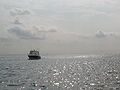
and Howells Point, and across which ferries
Ferry
A ferry is a form of transportation, usually a boat, but sometimes a ship, used to carry primarily passengers, and sometimes vehicles and cargo as well, across a body of water. Most ferries operate on regular, frequent, return services...
run south to Fire Island
Fire Island, New York
Fire Island is one of the outer barrier islands adjacent to the south shore of Long Island, New York. It is approximately long and varies between broad. Fire Island is part of Suffolk County. It comprises a number of hamlets, census-designated places , and villages, all of which lie within the...
.
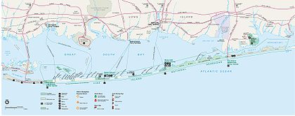
The Patchogue Bay bay bottom up to the barrier beach is owned by Brookhaven town though a grant by the King long before the existence of the union. It has been repeatedly adjudicated that the grant in the Dongan patent (Brookhaven Town,1686) is valid. However, since 1968 the Federal government has been attempting to take title of and claim, by adverse possession, the bay bottom of both Islip and Brookhaven Towns extending outward from the barrier beach. It (the Federal Government) has repeated published intentionally erroneous maps(as the one below) showing boundaries of the Fire Island Seashore extending out into the bay when the real boundary is the shoreline of the barrier beach.
Habitat
A number of habitats make up the bay bottom; the dominant eelgrassZostera
Zostera is a small genus of widely distributed seagrass, commonly called marine eelgrass or simply eelgrass . The genus Zostera contains sixteen species.-Ecology:Zostera is found on sandy substrates or in estuaries submerged or partially floating...
Benthic habitat in the cove's of Patchogue Bay which can be classified as muddy sandflat and sandflat habitats. Many species that are found in both habitats. Sandy bottom types worms, slipper shell, and blue mussel, and mud crab. Atlantic oyster dril, a predator of bivalves, is abundant in eelgrass beds in Patchogue and Bellport Bay, and rock crab. The distribution and abundance of benthic species in the bay's eelgrass community is likely controlled by a number of factors that include eelgrass stem density, water temperature and salinity
Salinity
Salinity is the saltiness or dissolved salt content of a body of water. It is a general term used to describe the levels of different salts such as sodium chloride, magnesium and calcium sulfates, and bicarbonates...
, sediment type, predation, food supply, and human harvest. Much of the bay is open water, while marshes and flats have developed on the protected northern edge of the barrier beach that shelters Patchogue Bay and the mainland from the Atlantic Ocean
Atlantic Ocean
The Atlantic Ocean is the second-largest of the world's oceanic divisions. With a total area of about , it covers approximately 20% of the Earth's surface and about 26% of its water surface area...
. Extensive tidal marshes and flats have developed on the bay side of Fire Island as well. Eelgrass beds are concentrated in the shallow waters along the back side of Fire Island, Silversides, killifish, menhaden, and bay anchovy. Forage fish species are found throughout the various aquatic habitats in the bay at different times of the year. Atlantic silverside, the most dominant member through much of the year, in most of the bay. Bay anchovy is the major mid-bay water column occupant in the summer during its spawning time in late June and July. Killifishes include mummichog in the salt marsh habitats, striped killifish
Striped killifish
The striped killifish , also called the striped mummichog, is a North American species of saltwater killifish , dwelling in shallow coastal waters close to shore, and is found from New Hampshire to Florida.It exhibits sexual dimorphism, with the males having vertical black stripes and the mature...
over sandy habitat, and sheepshead minnow
Sheepshead minnow
The sheepshead minnow is a subspecies of killifish found in salt marsh estuary environments....
in both habitats. Sticklebacks, including fourspine and threespine, are spring and summer spawners associated with submerged aquatic vegetation (SAV); although they are very abundant, their use as prey for other fish and birds is limited due to spines, body armor, and close association with vegetative cover. Northern pipefish
Pipefish
Pipefishes or pipe-fishes are a subfamily of small fishes, which, together with the seahorses, form the family Syngnathidae.-Anatomy:...
s) is a zooplankton consumer preyed upon by both striped bass
Striped bass
The striped bass is the state fish of Maryland, Rhode Island, South Carolina, and the state saltwater fish of New York, Virginia, and New Hampshire...
and summer flounder. American sandlance, probably the most abundant winter species, provides important forage for many species of special emphasis in the Bight. Summer flounder enter the bay in winter and spring and grow rapidly in the productive waters. The bay supports significant shellfishery for northern quahog and is a major spawning, nursery, and foraging area for blue crab.
Blue mussel
The blue mussel, Mytilus edulis, is a medium-sized edible marine bivalve mollusc in the family Mytilidae. In spite of its specific name edulis, it is not the sole edible Mytilus species.-Distribution:...
, bay scallop
Scallop
A scallop is a marine bivalve mollusk of the family Pectinidae. Scallops are a cosmopolitan family, found in all of the world's oceans. Many scallops are highly prized as a food source...
, eastern oyster
Eastern oyster
The eastern oyster — also called Atlantic oyster or Virginia oyster — is a species of true oyster native to the eastern seaboard and Gulf of Mexico coast of North America. It is also farmed in Puget Sound, Washington, where it is known as the Totten Inlet Virginica. Eastern oysters are and have...
, horseshoe crab
Horseshoe crab
The Atlantic horseshoe crab, Limulus polyphemus, is a marine chelicerate arthropod. Despite its name, it is more closely related to spiders, ticks, and scorpions than to crabs. Horseshoe crabs are most commonly found in the Gulf of Mexico and along the northern Atlantic coast of North America...
, American eel, spot, Atlantic croaker
Sciaenidae
Sciaenidae is a family of fish commonly called drums, croakers, or hardheads for the repetitive throbbing or drumming sounds they make...
, northern kingfish, and northern puffer. There are a number of significant trout resources in streams that drain into The Bay. Nine of the twelve verified wild brook trout
Brook trout
The brook trout, Salvelinus fontinalis, is a species of fish in the salmon family of order Salmoniformes. In many parts of its range, it is known as the speckled trout or squaretail. A potamodromous population in Lake Superior are known as coaster trout or, simply, as coasters...
populations of Long Island occur in the Bay's drainage. Patchogue's Swan River, and many other local tributaries such as Mud Creek, Patchogue Creek, and Terrel Creek all contain naturally reproducing populations of brook trout.
Today, Hard clam
Hard clam
The hard clam , also known as a quahog , round clam, or hard-shell clam, is an edible marine bivalve mollusk which is native to the eastern shores of North America, from Prince Edward Island to the Yucatán Peninsula...
s are the bay's principal resource, but this was not always the case. The once well-known eastern oyster fishery collapsed in the 1940s and 50's; that collapse was linked to algal blooms of a minute species that inhibited shellfish
Shellfish
Shellfish is a culinary and fisheries term for exoskeleton-bearing aquatic invertebrates used as food, including various species of molluscs, crustaceans, and echinoderms. Although most kinds of shellfish are harvested from saltwater environments, some kinds are found only in freshwater...
growth. These blooms were believed to be the result of high inputs of organic wastes, primarily from large-scale duck farms located on tributaries of the bay.
Fire Island access and Patchogue bays & bridges
- Davis Park
- Watch HillWatch Hill, New YorkWatch Hill is located on the western edge of the Otis Pike Fire Island High Dune Wilderness, across the Great South Bay from Patchogue, Long Island. It is accessible by Watch Hill Ferry, private boat, and foot only. The Otis Pike Fire Island High Dune Wilderness contains a variety of barrier...
- Fire Island National SeashoreFire Island National SeashoreFire Island National Seashore is a United States National Seashore that protects a section of Fire Island, an approximately long barrier island separated from Long Island by the Great South Bay....
- The Great South Bay
- Moriches BayMoriches BayMoriches Bay a lagoon system on the south shore of Long Island. The name Moriches comes from Meritces, a Native American who owned land on Moriches Neck.Two Townships both Brookhaven and the Southampton share Its shoreline in Suffolk New York....
- Swan River New York Google maps
- Pine NeckPine NeckPine Neck Avenue boat ramp and fishing pier are on the south shore of Long Island's East Patchogue, NY. Accessible by the Swan River and Pine Neck Ave, this is a main boat access ramp off the Swan River inlet, connecting the Patchogue Bay and Great South Bay, in south central Long Island.Pine Neck...
- (Boat launch) - Patchogue RiverPatchogue RiverThe Patchogue River is a mile-long waterway In Patchogue, New York that is lined with a variety restaurants, marinas, fueling docks, apartment condominiums, and ferry terminals.- Description :...
www.lat-long.com - Sandspit Park Beach & Marina
- Shorefront ParkShorefront ParkShorefront Park and the Patchogue Village Band Shell are located on Smith Street at the south end of Rider Aveue, Patchogue, New York.The Shorefront Park was designed that it may facilitate and play host to a variety of Outdoor events...
- Patchogue (Bandshell) - Mascot DockMascot DockMascot Dock & Marina are a village marina and dock stretching out into the waters of the Patchogue Bay at the end of South Ocean Avenue, in Patchogue, Suffolk County, NY....
& Marina - South Shore EstuarySouth Shore EstuaryThe South Shore Estuary is an estuary located along the south shore of Long Island, between the mainland and the outer barrier islands, in eastern New York state...
- Fire Island Wilderness
- Fire Island Inlet BridgeFire Island Inlet BridgeThe Fire Island Inlet Bridge, an integral part of the Robert Moses Causeway, is a two-lane, steel arch span with a concrete deck that carries Route 908 over Fire Island Inlet....
- Great South Bay BridgeGreat South Bay BridgeGreat South Bay Bridge is a bridge connecting the Robert Moses Causeway from Long Island's mainland over the Great South Bay, connecting to both Captree and Jones Beach Islands on the southwest central side of Long Island New York....
- Outer Barrier Islands
External links
- http://www.pagelinx.com/dpferry/dp.shtml (Davis Park- Ferry)
- http://www.watchhillfi.com/ferry.html (Watch Hill - Ferry)
- http://www.watchhillfi.com/directions.html
- http://home.nps.gov/fiis/planyourvisit/watchhillhours.htm
- http://greatsouthbaymusicfestival.com