
Orford Ness
Encyclopedia
Orford Ness is a cuspate foreland
shingle spit
on the Suffolk
coast in Great Britain
, linked to the mainland at Aldeburgh
and stretching along the coast to Orford
and down to North Wier Point, opposite Shingle Street
. It is divided from the mainland by the River Alde
, and was formed by longshore drift
along the coast. The material of the spit comes from places further north, such as Dunwich
. Near the middle point of its length, at the foreland point or 'Ness', lies the Orfordness lighthouse. Note that, in the name of the lighthouse (and the radio transmitting station - see below), ‘Orfordness’ is written as one word.
Orford Ness is an internationally important site for nature conservation. It contains a significant portion of the European reserve of vegetated shingle habitat, which is internationally scarce, highly fragile and very easily damaged. Together with Havergate Island
the site is a designated National Nature Reserve
and forms part of: the Alde-Ore Estuary Site of Special Scientific Interest
(SSSI); the Alde, Ore & Butley Estuaries and the Orfordness-Shingle Street Special Area of Conservation
(SAC); the Alde-Ore Estuary Special Protection Area
(SPA); the Alde-Ore Estuary Ramsar Site
site; the Suffolk Coasts and Heaths Area of Outstanding Natural Beauty
(AONB); and the Suffolk Heritage Coast. It is also listed as of national importance in the Geological Conservation Review
(GC), as a grade 1 site in the Nature Conservation Review. (NCR) and qualifies for the DEFRA Environmentally Sensitive Area (ESA) scheme.
, which conducted secret military
tests during both world wars and the Cold War
. The Atomic Weapons Research Establishment had a base on the site, used for environmental testing. When a laboratory test is conducted to determine the functional performance of a component or system under conditions that simulate the real environment in which the component or system is expected to operate. Many of the buildings from this time remain clearly visible from the quay at Orford, including the distinctive "pagodas". Whilst it is maintained that no fissile material was tested on the site, the very high explosive initiator charge was present and the buildings were designed to absorb any accidental explosion, allowing gases and other material to vent and dissipate in a directed or contained manner. In the event of a larger accident, the roofs were designed to collapse onto the building, sealing it with a lid of concrete.
The Orfordness transmitting station was built on the peninsula in the late 1970s and early 1980s using the site and building of an experimental military over-the-horizon radar
known as Cobra Mist
, which had closed in 1973. This powerful mediumwave radio
station - originally owned and run by the Foreign Office
, then the BBC
and, after privatization in the 1990s, a series of private companies - is best known for transmitting BBC World Service
in English around the clock to continental Europe on 648 kHz from September 1982 until March 2011. Following the ending of these broadcasts, and with no other major clients for the station, its future is uncertain.
In the 1930s Orford Ness was the site of the first purpose built experiments on the defence system that would later be known as radar. Having proved the technology on Orford Ness Robert Watson-Watt
and his team moved to nearby Bawdsey
Manor and developed the Chain Home
radar system in time for its vital role in the Battle of Britain.
Orford Ness is now owned by the National Trust
and is open to the public under the name "Orford Ness National Nature Reserve", though access is strictly controlled to protect the fragile habitats and due to a residual danger to the public from the site's former use by the military. Access is therefore only available by the National Trust ferry from Orford Quay on designated open days.
Rachel Woodward writes:
Owing to its military history, its stark appearance and the fact that it was closed to the public for many decades, several apocryphal stories have circulated about Orford Ness. The best-known is the suggestion that Nazi
troops attempted to invade England and actually disembarked at the tip of the peninsula near Shingle Street
, before being repelled with a wall of fire. Official sources denied any such attempted invasion took place, an assertion apparently confirmed by classified documents released in 1993. More recently, the flashes of the lighthouse were implicated in the Rendlesham Forest UFO sightings
of late December 1980.
The spit formed almost entirely of flint deposited by waves through the process of long-shore drift. The main influence on its formation has been storm waves throwing shingle over the top of the beach crest, where it is protected from ordinary wave action. Over time, this process leads to the formation of stable ridges of fine particles, and swails of coarser shingle.
The size and shape of the spit fluctuates over time (see map). Estimated growth rates range from 64m per year in 1962 to 1967, to 183m per year in 1804 to 1812. Between 1812 and 1821, the total length fluctuated by 1.8 miles (2.9 km). As a result of the dynamically changing nature of the spit, the true age of its formation is unknown. However, before about 1200, Orford is thought to have been a port facing the open sea.
Cuspate foreland
Cuspate forelands, also known as cuspate barriers or Nesses in Britain, are geographical features found on coastlines and lakeshores that are created primarily by long shore drift. Formed by accretion and progradation of sand and shingle, they extend outwards from the shoreline in a triangular shape...
shingle spit
Spit (landform)
A spit or sandspit is a deposition landform found off coasts. At one end, spits connect to land, and extend into the sea. A spit is a type of bar or beach that develops where a re-entrant occurs, such as at cove's headlands, by the process of longshore drift...
on the Suffolk
Suffolk
Suffolk is a non-metropolitan county of historic origin in East Anglia, England. It has borders with Norfolk to the north, Cambridgeshire to the west and Essex to the south. The North Sea lies to the east...
coast in Great Britain
Great Britain
Great Britain or Britain is an island situated to the northwest of Continental Europe. It is the ninth largest island in the world, and the largest European island, as well as the largest of the British Isles...
, linked to the mainland at Aldeburgh
Aldeburgh
Aldeburgh is a coastal town in Suffolk, East Anglia, England. Located on the River Alde, the town is notable for its Blue Flag shingle beach and fisherman huts where freshly caught fish are sold daily, and the Aldeburgh Yacht Club...
and stretching along the coast to Orford
Orford, Suffolk
Orford is a small town in Suffolk, England, within the Suffolk Coast and Heaths AONB.Like many Suffolk coastal towns it was of some importance as a port and fishing village in the Middle Ages. It still has a fine mediaeval castle, built to dominate the River Ore.The main geographical feature of the...
and down to North Wier Point, opposite Shingle Street
Shingle Street
Shingle Street is a small coastal hamlet in Suffolk, England, at the mouth of Orford Ness, situated between Orford and Bawdsey. This part of the coast is also known as Hollesley Bay and there is the HM Young Offender Institution, Hollesley Bay Colony nearby....
. It is divided from the mainland by the River Alde
River Alde
The River Alde is a river in Suffolk, England, with a source near Laxfield in the same area as the River Blyth. Initially a stream, it becomes tidal and widens considerably when it reaches Snape. It meanders east past Aldeburgh, after which this part of the river was named...
, and was formed by longshore drift
Longshore drift
Longshore drift consists of the transportation of sediments along a coast at an angle to the shoreline, which is dependent on prevailing wind direction, swash and backwash. This process occurs in the littoral zone, and in or within close proximity to the surf zone...
along the coast. The material of the spit comes from places further north, such as Dunwich
Dunwich
Dunwich is a small town in Suffolk, England, within the Suffolk Coast and Heaths AONB.Dunwich was the capital of East Anglia 1500 years ago but the harbour and most of the town have since disappeared due to coastal erosion. Its decline began in 1286 when a sea surge hit the East Anglian coast, and...
. Near the middle point of its length, at the foreland point or 'Ness', lies the Orfordness lighthouse. Note that, in the name of the lighthouse (and the radio transmitting station - see below), ‘Orfordness’ is written as one word.
Orford Ness is an internationally important site for nature conservation. It contains a significant portion of the European reserve of vegetated shingle habitat, which is internationally scarce, highly fragile and very easily damaged. Together with Havergate Island
Havergate Island
Havergate Island is the only island in the county of Suffolk, England. It is found at the confluence of the River Ore and the River Butley near the village of Orford. It is a marshy nature reserve run by the Royal Society for the Protection of Birds and is known for its population of avocets and...
the site is a designated National Nature Reserve
National Nature Reserve
For details of National nature reserves in the United Kingdom see:*National Nature Reserves in England*National Nature Reserves in Northern Ireland*National Nature Reserves in Scotland*National Nature Reserves in Wales...
and forms part of: the Alde-Ore Estuary Site of Special Scientific Interest
Site of Special Scientific Interest
A Site of Special Scientific Interest is a conservation designation denoting a protected area in the United Kingdom. SSSIs are the basic building block of site-based nature conservation legislation and most other legal nature/geological conservation designations in Great Britain are based upon...
(SSSI); the Alde, Ore & Butley Estuaries and the Orfordness-Shingle Street Special Area of Conservation
Special Area of Conservation
A Special Area of Conservation is defined in the European Union's Habitats Directive , also known as the Directive on the Conservation of Natural Habitats and of Wild Fauna and Flora...
(SAC); the Alde-Ore Estuary Special Protection Area
Special Protection Area
A Special Protection Area or SPA is a designation under the European Union Directive on the Conservation of Wild Birds.Under the Directive, Member States of the European Union have a duty to safeguard the habitats of migratory birds and certain particularly threatened birds.Together with Special...
(SPA); the Alde-Ore Estuary Ramsar Site
Ramsar Convention
The Ramsar Convention is an international treaty for the conservation and sustainable utilization of wetlands, i.e., to stem the progressive encroachment on and loss of wetlands now and in the future, recognizing the fundamental ecological functions of wetlands and their economic, cultural,...
site; the Suffolk Coasts and Heaths Area of Outstanding Natural Beauty
Area of Outstanding Natural Beauty
An Area of Outstanding Natural Beauty is an area of countryside considered to have significant landscape value in England, Wales or Northern Ireland, that has been specially designated by the Countryside Agency on behalf of the United Kingdom government; the Countryside Council for Wales on...
(AONB); and the Suffolk Heritage Coast. It is also listed as of national importance in the Geological Conservation Review
Geological Conservation Review
The Geological Conservation Review is produced by the UK's Joint Nature Conservation Committee and is designed to identify those sites of national and international importance needed to show all the key scientific elements of the geological and geomorphological features of Britain...
(GC), as a grade 1 site in the Nature Conservation Review. (NCR) and qualifies for the DEFRA Environmentally Sensitive Area (ESA) scheme.
History
The peninsula was formerly administered by the Ministry of DefenceMinistry of Defence (United Kingdom)
The Ministry of Defence is the United Kingdom government department responsible for implementation of government defence policy and is the headquarters of the British Armed Forces....
, which conducted secret military
Military
A military is an organization authorized by its greater society to use lethal force, usually including use of weapons, in defending its country by combating actual or perceived threats. The military may have additional functions of use to its greater society, such as advancing a political agenda e.g...
tests during both world wars and the Cold War
Cold War
The Cold War was the continuing state from roughly 1946 to 1991 of political conflict, military tension, proxy wars, and economic competition between the Communist World—primarily the Soviet Union and its satellite states and allies—and the powers of the Western world, primarily the United States...
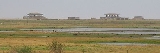
. The Atomic Weapons Research Establishment had a base on the site, used for environmental testing. When a laboratory test is conducted to determine the functional performance of a component or system under conditions that simulate the real environment in which the component or system is expected to operate. Many of the buildings from this time remain clearly visible from the quay at Orford, including the distinctive "pagodas". Whilst it is maintained that no fissile material was tested on the site, the very high explosive initiator charge was present and the buildings were designed to absorb any accidental explosion, allowing gases and other material to vent and dissipate in a directed or contained manner. In the event of a larger accident, the roofs were designed to collapse onto the building, sealing it with a lid of concrete.
The Orfordness transmitting station was built on the peninsula in the late 1970s and early 1980s using the site and building of an experimental military over-the-horizon radar
Over-the-horizon radar
Over-the-horizon radar, or OTH , is a design concept for radar systems to allow them to detect targets at very long ranges, typically up to thousands of kilometers...
known as Cobra Mist
Cobra Mist
Cobra Mist was the codename for an Anglo-American experimental over-the-horizon radar station at Orford Ness, Suffolk, England . It was known technically as AN/FPS-95 and sometimes referred to as System 441a; a reference to the project as a whole. Cobra Mist was part of a small number of "Cobra"...
, which had closed in 1973. This powerful mediumwave radio
Mediumwave
Medium wave is the part of the medium frequency radio band used mainly for AM radio broadcasting. For Europe the MW band ranges from 526.5 kHz to 1606.5 kHz...
station - originally owned and run by the Foreign Office
Foreign and Commonwealth Office
The Foreign and Commonwealth Office, commonly called the Foreign Office or the FCO is a British government department responsible for promoting the interests of the United Kingdom overseas, created in 1968 by merging the Foreign Office and the Commonwealth Office.The head of the FCO is the...
, then the BBC
BBC
The British Broadcasting Corporation is a British public service broadcaster. Its headquarters is at Broadcasting House in the City of Westminster, London. It is the largest broadcaster in the world, with about 23,000 staff...
and, after privatization in the 1990s, a series of private companies - is best known for transmitting BBC World Service
BBC World Service
The BBC World Service is the world's largest international broadcaster, broadcasting in 27 languages to many parts of the world via analogue and digital shortwave, internet streaming and podcasting, satellite, FM and MW relays...
in English around the clock to continental Europe on 648 kHz from September 1982 until March 2011. Following the ending of these broadcasts, and with no other major clients for the station, its future is uncertain.
In the 1930s Orford Ness was the site of the first purpose built experiments on the defence system that would later be known as radar. Having proved the technology on Orford Ness Robert Watson-Watt
Robert Watson-Watt
Sir Robert Alexander Watson-Watt, KCB, FRS, FRAeS is considered by many to be the "inventor of radar". Development of radar, initially nameless, was first started elsewhere but greatly expanded on 1 September 1936 when Watson-Watt became...
and his team moved to nearby Bawdsey
Bawdsey
Bawdsey is a village and civil parish in Suffolk, eastern England. Located near Felixstowe, it had an estimated population of 340 in 2007.Bawdsey Manor is notable as the place where radar research took place early in World War II, before moving to Worth Matravers, which is four miles to the west of...
Manor and developed the Chain Home
Chain Home
Chain Home was the codename for the ring of coastal Early Warning radar stations built by the British before and during the Second World War. The system otherwise known as AMES Type 1 consisted of radar fixed on top of a radio tower mast, called a 'station' to provide long-range detection of...
radar system in time for its vital role in the Battle of Britain.
Orford Ness is now owned by the National Trust
National Trust for Places of Historic Interest or Natural Beauty
The National Trust for Places of Historic Interest or Natural Beauty, usually known as the National Trust, is a conservation organisation in England, Wales and Northern Ireland...
and is open to the public under the name "Orford Ness National Nature Reserve", though access is strictly controlled to protect the fragile habitats and due to a residual danger to the public from the site's former use by the military. Access is therefore only available by the National Trust ferry from Orford Quay on designated open days.
Rachel Woodward writes:
Owing to its military history, its stark appearance and the fact that it was closed to the public for many decades, several apocryphal stories have circulated about Orford Ness. The best-known is the suggestion that Nazi
Nazism
Nazism, the common short form name of National Socialism was the ideology and practice of the Nazi Party and of Nazi Germany...
troops attempted to invade England and actually disembarked at the tip of the peninsula near Shingle Street
Shingle Street
Shingle Street is a small coastal hamlet in Suffolk, England, at the mouth of Orford Ness, situated between Orford and Bawdsey. This part of the coast is also known as Hollesley Bay and there is the HM Young Offender Institution, Hollesley Bay Colony nearby....
, before being repelled with a wall of fire. Official sources denied any such attempted invasion took place, an assertion apparently confirmed by classified documents released in 1993. More recently, the flashes of the lighthouse were implicated in the Rendlesham Forest UFO sightings
Rendlesham Forest Incident
The Rendlesham Forest Incident is the name given to a series of reported sightings of unexplained lights and the alleged landing of a craft or multiple craft of unknown origin in Rendlesham Forest, Suffolk, England, in late December 1980, just outside RAF Woodbridge, used at the time by the U.S....
of late December 1980.
Geography
Orford Ness is Europe's largest vegetated shingle spit. It is approximately 10 miles (16.1 km) long, and the site covers a total area of approximately 2230 acres (902.4 ha). Forty percent of this (890 acres) is shingle, 25 percent (556 acres) tidal rivers, mud flats, sand flats, and lagoons, eighteen percent (400 acres) grassland, and fifteen percent (330 acres) salt marsh.The spit formed almost entirely of flint deposited by waves through the process of long-shore drift. The main influence on its formation has been storm waves throwing shingle over the top of the beach crest, where it is protected from ordinary wave action. Over time, this process leads to the formation of stable ridges of fine particles, and swails of coarser shingle.
The size and shape of the spit fluctuates over time (see map). Estimated growth rates range from 64m per year in 1962 to 1967, to 183m per year in 1804 to 1812. Between 1812 and 1821, the total length fluctuated by 1.8 miles (2.9 km). As a result of the dynamically changing nature of the spit, the true age of its formation is unknown. However, before about 1200, Orford is thought to have been a port facing the open sea.
See also
- Wartime events at Shingle StreetShingle StreetShingle Street is a small coastal hamlet in Suffolk, England, at the mouth of Orford Ness, situated between Orford and Bawdsey. This part of the coast is also known as Hollesley Bay and there is the HM Young Offender Institution, Hollesley Bay Colony nearby....
, SuffolkSuffolkSuffolk is a non-metropolitan county of historic origin in East Anglia, England. It has borders with Norfolk to the north, Cambridgeshire to the west and Essex to the south. The North Sea lies to the east...
, are explored in more detail in two books by James HaywardJames HaywardJames Hayward is the pseudonym of James Nice , English writer on military and modern art history. Educated at the University of Glasgow prior to working in publishing and as a solicitor...
. - Orford CastleOrford CastleOrford Castle is a castle in the village of Orford, Suffolk, England, located 12 miles northeast of Ipswich, with views over the Orford Ness. It was built between 1165 and 1173 by Henry II of England to consolidate royal power in the region. The well-preserved keep, described by historian R...
Norman keep overlooking Orfordness and Orford Island. - Havergate IslandHavergate IslandHavergate Island is the only island in the county of Suffolk, England. It is found at the confluence of the River Ore and the River Butley near the village of Orford. It is a marshy nature reserve run by the Royal Society for the Protection of Birds and is known for its population of avocets and...
— RSPB Reserve - Seaplane Experimental StationSeaplane Experimental StationThe Seaplane Experimental Station at Royal Naval Air Station Felixstowe was a British aircraft design unit of the early part of the 20th century.-Creation:...
, another research station at FelixstoweFelixstoweFelixstowe is a seaside town on the North Sea coast of Suffolk, England. The town gives its name to the nearby Port of Felixstowe, which is the largest container port in the United Kingdom and is owned by Hutchinson Ports UK... - Aeroplane and Armament Experimental EstablishmentAeroplane and Armament Experimental EstablishmentThe Aeroplane and Armament Experimental Establishment was a research facility for British military aviation from 1918 to 1992.-History:...
, yet another nearby experimental station at Martlesham Heath Airfield
External links
- LIFE+ project; Alde-Ore future for wildlife
- Orford Ness National Nature Reserve information at the National Trust
- Orfordness and Orford Island Boat Trips — Lady Florence, Orford Quay, Suffolk
- My Orford by Charlie Underwood - An interesting insight into village life in Orford