

Oresund
Encyclopedia
Strait
A strait or straits is a narrow, typically navigable channel of water that connects two larger, navigable bodies of water. It most commonly refers to a channel of water that lies between two land masses, but it may also refer to a navigable channel through a body of water that is otherwise not...
that separates the Danish
Denmark
Denmark is a Scandinavian country in Northern Europe. The countries of Denmark and Greenland, as well as the Faroe Islands, constitute the Kingdom of Denmark . It is the southernmost of the Nordic countries, southwest of Sweden and south of Norway, and bordered to the south by Germany. Denmark...
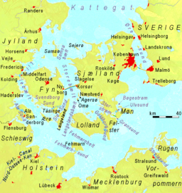
island Zealand from the southern Swedish province of Scania
Scania
Scania is the southernmost of the 25 traditional non-administrative provinces of Sweden, constituting a peninsula on the southern tip of the Scandinavian peninsula, and some adjacent islands. The modern administrative subdivision Skåne County is almost, but not totally, congruent with the...
. Its width is just 4 kilometres (2.5 mi) at the narrowest point between Helsingør, Denmark, and Helsingborg
Helsingborg
Helsingborg is a city and the seat of Helsingborg Municipality, Skåne County, Sweden with 97,122 inhabitants in 2010. Helsingborg is the centre of an area in the Øresund region of about 320,000 inhabitants in north-west Scania, and is Sweden's closest point to Denmark, with the Danish city...
, Sweden. The strait has also lent its name to the Øresund Region of 3.7 million inhabitants on both the Danish and Swedish sides.
Øresund is one of the three Danish Straits
Danish straits
The Danish straits are the three channels connecting the Baltic Sea to the North Sea through the Kattegat and Skagerrak. They transect Denmark, and are not to be confused with the Denmark Strait between Greenland and Iceland...
that connects the Baltic Sea
Baltic Sea
The Baltic Sea is a brackish mediterranean sea located in Northern Europe, from 53°N to 66°N latitude and from 20°E to 26°E longitude. It is bounded by the Scandinavian Peninsula, the mainland of Europe, and the Danish islands. It drains into the Kattegat by way of the Øresund, the Great Belt and...
to the Atlantic Ocean
Atlantic Ocean
The Atlantic Ocean is the second-largest of the world's oceanic divisions. With a total area of about , it covers approximately 20% of the Earth's surface and about 26% of its water surface area...
via Kattegat
Kattegat
The Kattegat , or Kattegatt is a sea area bounded by the Jutland peninsula and the Straits islands of Denmark on the west and south, and the provinces of Västergötland, Scania, Halland and Bohuslän in Sweden on the east. The Baltic Sea drains into the Kattegat through the Øresund and the Danish...
, Skagerrak
Skagerrak
The Skagerrak is a strait running between Norway and the southwest coast of Sweden and the Jutland peninsula of Denmark, connecting the North Sea and the Kattegat sea area, which leads to the Baltic Sea.-Name:...
and the North Sea
North Sea
In the southwest, beyond the Straits of Dover, the North Sea becomes the English Channel connecting to the Atlantic Ocean. In the east, it connects to the Baltic Sea via the Skagerrak and Kattegat, narrow straits that separate Denmark from Norway and Sweden respectively...
, and is one of the busiest waterways in the world.
The Øresund Bridge was inaugurated on July 1 2000, by King Carl XVI Gustaf of Sweden
Carl XVI Gustaf of Sweden
Carl XVI Gustaf is the reigning King of Sweden since 15 September 1973, succeeding his grandfather King Gustaf VI Adolf because his father had predeceased him...
and Queen Margrethe II of Denmark
Margrethe II of Denmark
Margrethe II is the Queen regnant of the Kingdom of Denmark. In 1972 she became the first female monarch of Denmark since Margaret I, ruler of the Scandinavian countries in 1375-1412 during the Kalmar Union.-Early life:...
. Ferries run around the clock between Helsingborg
Helsingborg
Helsingborg is a city and the seat of Helsingborg Municipality, Skåne County, Sweden with 97,122 inhabitants in 2010. Helsingborg is the centre of an area in the Øresund region of about 320,000 inhabitants in north-west Scania, and is Sweden's closest point to Denmark, with the Danish city...
, Sweden and Helsingør, Denmark.
Etymology
The oldest known name of the strait is urasu[n]ti which appears on a runestone from about 950 and it was locally known as Oresund in the 13th century. The strait is today called Øresund in DanishDanish language
Danish is a North Germanic language spoken by around six million people, principally in the country of Denmark. It is also spoken by 50,000 Germans of Danish ethnicity in the northern parts of Schleswig-Holstein, Germany, where it holds the status of minority language...
and Öresund in Swedish
Swedish language
Swedish is a North Germanic language, spoken by approximately 10 million people, predominantly in Sweden and parts of Finland, especially along its coast and on the Åland islands. It is largely mutually intelligible with Norwegian and Danish...
, informally Sundet in both languages. The prefix ør(e) means gravel beach and a sund is a sound
Sound (geography)
In geography a sound or seaway is a large sea or ocean inlet larger than a bay, deeper than a bight and wider than a fjord; or it may be defined as a narrow sea or ocean channel between two bodies of land ....
or narrow seaway.
Streams, animals and salinity
Øresund, and also being at the border between oceanic salt water (with a salinity of more than 30 PSUSalinity
Salinity is the saltiness or dissolved salt content of a body of water. It is a general term used to describe the levels of different salts such as sodium chloride, magnesium and calcium sulfates, and bicarbonates...
) and the Baltic sea (only 3–7 PSU) has rather unique water conditions. The streams are very complex, but the surface stream is often northbound (from the Baltic sea) which gives a lower surface salinity, though streams can change from one day to another. The average surface salinity is about 10-12 PSU in the southern part but above 20 PSU north of Helsingør.
At the bottom of the sea, conditions are more stable and salinity is always oceanic (> 30 PSU) below a certain depth that varies between 10 and 15 meters. In the southern part, however, the depth is just 7-10 meters, and this is the definite border of oceanic salt water, therefore also a border for many maritine species of animals. In the central Baltic Sea only 52 known salt-water species resided compare with around 1500 in the North Sea. Close to 600 species are known to exist in at least some part of Øresund. Well-known examples include lobster and the burning jellyfish (of Cyanea Artica); the latter can sometimes drift into the southwest Baltic sea, but it cannot reproduce there.
History
Political control of Øresund has been an important issue in Danish and SwedishSweden
Sweden , officially the Kingdom of Sweden , is a Nordic country on the Scandinavian Peninsula in Northern Europe. Sweden borders with Norway and Finland and is connected to Denmark by a bridge-tunnel across the Öresund....
history. Denmark maintained military
Military
A military is an organization authorized by its greater society to use lethal force, usually including use of weapons, in defending its country by combating actual or perceived threats. The military may have additional functions of use to its greater society, such as advancing a political agenda e.g...
control with the coast
Coast
A coastline or seashore is the area where land meets the sea or ocean. A precise line that can be called a coastline cannot be determined due to the dynamic nature of tides. The term "coastal zone" can be used instead, which is a spatial zone where interaction of the sea and land processes occurs...
al fortress of Kronborg at Elsinore
Elsinore
Helsingør is a city and the municipal seat of Helsingør municipality on the northeast coast of the island of Zealand in eastern Denmark. Helsingør has a population of 46,279 including the southern suburbs of Snekkersten and Espergærde...
on the west side and Kärnan
Kärnan
Kärnan is a medieval tower in Helsingborg, Scania, in southern Sweden. It is the only part remaining of a larger Danish fortress which, along with the fortress Kronborg on the opposite of Oresund, controlled the entranceway to the Baltic Sea.-History:...
at Helsingborg
Helsingborg
Helsingborg is a city and the seat of Helsingborg Municipality, Skåne County, Sweden with 97,122 inhabitants in 2010. Helsingborg is the centre of an area in the Øresund region of about 320,000 inhabitants in north-west Scania, and is Sweden's closest point to Denmark, with the Danish city...
on the east, until the eastern shore was ceded to Sweden in 1658. Both fortresses are located where the strait is just 4 kilometers wide.
In 1429 King Eric of Pomerania
Eric of Pomerania
Eric of Pomerania KG was King Eric III of Norway Norwegian Eirik, King Eric VII of Denmark , and as Eric King of Sweden...
introduced the Sound Dues
Sound Dues
The Sound Dues were a toll on the use of the Sound which constituted up to two thirds of Denmark's state income in the 16th and 17th centuries...
which remained in effect for more than four centuries, until 1857. Transitory dues on the use of waterways, roads, bridges and crossings were then an accepted way of taxing which could constitute a great part of a state's income. The Sound Dues remained the most important source of income for the Danish Crown for several centuries, thus making Danish kings relatively independent of Denmark's Privy Council and aristocracy
Aristocracy
Aristocracy , is a form of government in which a few elite citizens rule. The term derives from the Greek aristokratia, meaning "rule of the best". In origin in Ancient Greece, it was conceived of as rule by the best qualified citizens, and contrasted with monarchy...
.

Notable islands
- AmagerAmagerAmager is a Danish island in the Øresund. The Danish capital, Copenhagen, is partly situated on Amager, which is connected to the much larger island of Zealand by five bridges.-History:...
- SaltholmSaltholmSaltholm is a Danish island in the Øresund, the strait that separates Denmark and Sweden. It is located to the east of the Danish island of Amager in Tårnby municipality and lies just to the west of the sea border between Denmark and Sweden. It is 7 km long and 3 km wide, covering an...
- Ven (also spelled Hven)
- PeberholmPeberholmPeberholm , Swedish Pepparholm, is a small artificial island located in the Danish part of the Øresund. It forms part of Tårnby municipality. It was created as part of the Øresund Bridge connecting Denmark with Sweden...
- an artificial islandArtificial islandAn artificial island or man-made island is an island or archipelago that has been constructed by people rather than formed by natural means... - MiddelgrundsfortetMiddelgrundsfortetMiddelgrundsfortet is a sea fortress located in the Øresund between Copenhagen and Malmö. It was constructed 1890–94 as a part of Copenhagen's sea-fortifications, partly from material excavated from Frihavnen...
- an artificial islandArtificial islandAn artificial island or man-made island is an island or archipelago that has been constructed by people rather than formed by natural means... - FlakfortetFlakfortetFlakfortet is a sea fortress located on the artificially built island, Saltholmreb, in Øresund between Copenhagen and Malmö. The island and fort are simply known as Flakfortet, the name of the island, Saltholmreb, is seldom used....
- an artificial islandArtificial islandAn artificial island or man-made island is an island or archipelago that has been constructed by people rather than formed by natural means... - Gråen - a semi artificial island outside port of Landskrona
See also
- Øresund Region
- Øresund Bridge
- Danish straitsDanish straitsThe Danish straits are the three channels connecting the Baltic Sea to the North Sea through the Kattegat and Skagerrak. They transect Denmark, and are not to be confused with the Denmark Strait between Greenland and Iceland...
- Great BeltGreat BeltThe Great Belt is a strait between the main Danish islands of Zealand and Funen . Effectively dividing Denmark in two, the Belt was served by the Great Belt ferries from the late 19th century until the islands were connected by the Great Belt Fixed Link in 1997–98.-Geography:The Great Belt is the...
- Øresund stationØresund stationØresund Station is a station on the Copenhagen Metro located in the Sundbyøster district of Copenhagen. It opened on 28 September 2007.The station services the M2 line. It is located in fare zone 3.-External links:* *...
on the Copenhagen MetroCopenhagen MetroCopenhagen Metro is a rapid transit system serving Copenhagen, Frederiksberg and Tårnby in Denmark. The system opened between 2002 and 2007, and has two lines, M1 and M2. The driverless light metro supplements the larger S-train rapid transit system, and is integrated with DSB local trains and...
External links
- Øresunddirekt - Official public information site for the inhabitants of the Øresund region
- Øresund Trends - An official public information site with up-to-date information on the region, available in English
- Øresundstid - The History of the Øresund Region (English, Swedish, Danish)