

Great Belt
Encyclopedia
Strait
A strait or straits is a narrow, typically navigable channel of water that connects two larger, navigable bodies of water. It most commonly refers to a channel of water that lies between two land masses, but it may also refer to a navigable channel through a body of water that is otherwise not...
between the main Danish
Denmark
Denmark is a Scandinavian country in Northern Europe. The countries of Denmark and Greenland, as well as the Faroe Islands, constitute the Kingdom of Denmark . It is the southernmost of the Nordic countries, southwest of Sweden and south of Norway, and bordered to the south by Germany. Denmark...
islands of Zealand (Sjælland) and Funen
Funen
Funen , with a size of 2,984 km² , is the third-largest island of Denmark following Zealand and Vendsyssel-Thy, and the 163rd largest island of the world. Funen is located in the central part of the country and has a population of 454,358 inhabitants . The main city is Odense, connected to the...
(Fyn). Effectively dividing Denmark in two, the Belt was served by the Great Belt ferries
Great Belt ferries
The Great Belt ferries were the train and car ferries operating across the Danish strait of Great Belt, between the islands of Zealand and Funen...
from the late 19th century until the islands were connected by the Great Belt Fixed Link
Great Belt Fixed Link
The Great Belt Fixed Link is the fixed link between the Danish islands of Zealand and Funen across the Great Belt. It consists of a road suspension bridge and railway tunnel between Zealand and the island Sprogø, as well as a box girder bridge between Sprogø and Funen...
in 1997–98.
Geography

Denmark
Denmark is a Scandinavian country in Northern Europe. The countries of Denmark and Greenland, as well as the Faroe Islands, constitute the Kingdom of Denmark . It is the southernmost of the Nordic countries, southwest of Sweden and south of Norway, and bordered to the south by Germany. Denmark...
that connect the Kattegat
Kattegat
The Kattegat , or Kattegatt is a sea area bounded by the Jutland peninsula and the Straits islands of Denmark on the west and south, and the provinces of Västergötland, Scania, Halland and Bohuslän in Sweden on the east. The Baltic Sea drains into the Kattegat through the Øresund and the Danish...
to the Baltic Sea
Baltic Sea
The Baltic Sea is a brackish mediterranean sea located in Northern Europe, from 53°N to 66°N latitude and from 20°E to 26°E longitude. It is bounded by the Scandinavian Peninsula, the mainland of Europe, and the Danish islands. It drains into the Kattegat by way of the Øresund, the Great Belt and...
. The others are the Oresund
Oresund
The Sound , is the strait that separates the Danish island Zealand from the southern Swedish province of Scania. Its width is just at the narrowest point between Helsingør, Denmark, and Helsingborg, Sweden...
and the Little Belt
Little Belt
The Little Belt is a strait between the Danish island of Funen and the Jutland Peninsula.The belt is about 50 km long and 800m to 28 km wide, the maximum depth is approximately 75 m, and contains numerous small Danish islands....
.
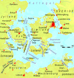
The Great Belt is 60 kilometers long and 16–32 kilometers wide. It flows around two major islands: Samsø
Samsø
Samsø is a Danish island in the Kattegat off the Jutland Peninsula. Samsø is located in Samsø municipality. The community has 4,300 inhabitants called Samsingers and is 114 km² in area. Due to its central location, the island was used during the Viking Age as a meeting place...
in the north and Langeland
Langeland
Langeland is a Danish island located between the Great Belt and Bay of Kiel. The island measures 285 km² and, as of 1 January 2010, has a population of 13,277. The island produces grain and is known as a recreational area. A bridge connects it to Tåsinge via Siø - a small island with a...
to the south. At Sprogø the Great Belt divides into the East Channel and the West Channel. Both are traversed by the Great Belt Bridge, but a tunnel also runs under the East Channel.
Geology
In pre-glacial times a river, which the Baltic Sea basin then contained, must have passed through the region. So also did the Eemian SeaEemian sea
The Eemian sea was a body of water located approximately where the Baltic sea is now during the last or Eemian Stage, MIS 5e, roughly 130,000 to 115,000 BP. Sea level was 5 to 7 metres higher globally than it is today, due to the prior release of glacial water...
, just prior to the last glaciation, which covered the entire region with ice thousands of metres (many more thousands of feet) thick. Today's topography is totally post-glacial. The Great Belt was eroded into existence by streams passing between the Baltic sea basin and the Kattegat. Currently it is a drowned channel.
It is possible to speak of northern and southern zones beneath the surface. The northern one consists of two v-shaped cuts more than 50 metres deep. The southern one has a relatively shallow bottom, 30 metres deep, showing the tops of riverine and lacustrine sediments. This configuration gives evidence that for most of its life the Great Belt hosted an outward, downhill flow.
The northern zone is located in the sea off the north coast of Zeeland. The southern zone is just south of Langeland, leading into the Kieler Bucht, or Bay of Kiel
Bay of Kiel
The Bay of Kiel is a bay in the southwestern Baltic Sea, off the shores of Schleswig-Holstein in Germany and the islands of Denmark. It is connected with the Bay of Mecklenburg in the east, the Little Belt in the northwest, and the Great Belt in the North....
. The Fehmarn Belt
Fehmarn Belt
Fehmarn Belt is a strait connecting the Bay of Kiel and the Bay of Mecklenburg in the western part of the Baltic Sea between the German island of Fehmarn and the Danish island of Lolland. Ferries operated by Scandlines connect Puttgarden and Rødby on the two islands.The strait features a...
then connects the Kieler Bucht to the Lübecker Bucht, or Bay of Lübeck
Bay of Lübeck
The Bay of Lübeck is a basin in the southwestern Baltic Sea, off the shores of German lands of Mecklenburg-Vorpommern and Schleswig-Holstein. It forms the southwestern part of the Bay of Mecklenburg....
, to the south of Lolland
Lolland
Lolland is the fourth largest island of Denmark, with an area of 1,243 square kilometers . Located in the Baltic sea, it is part of Region Sjælland...
. The Bay of Lübeck
Bay of Lübeck
The Bay of Lübeck is a basin in the southwestern Baltic Sea, off the shores of German lands of Mecklenburg-Vorpommern and Schleswig-Holstein. It forms the southwestern part of the Bay of Mecklenburg....
is open to the Baltic sea.
The current channel of the Great Belt was created by a relatively high fresh water phase of the rising Yoldia Sea
Yoldia Sea
Yoldia Sea is a name given by geologists to a variable brackish-water stage in the Baltic Sea basin that prevailed after the Baltic ice lake was drained to sea level during the Weichsel glaciation...
breaking through to the lower Kattegat levels at about 10,000 BP. At that time the exposed northern zone was a valley less than 1 kilometer wide.
The Yoldia sea continued to drain and levels in the Kattegat
Kattegat
The Kattegat , or Kattegatt is a sea area bounded by the Jutland peninsula and the Straits islands of Denmark on the west and south, and the provinces of Västergötland, Scania, Halland and Bohuslän in Sweden on the east. The Baltic Sea drains into the Kattegat through the Øresund and the Danish...
continued to rise. By 9500 BC the outward flow stopped and the sea proper began to penetrate the enlarged Great Belt, turning it brackish very slowly. During the Ancylus Lake
Ancylus Lake
Ancylus lake is a name given by geologists to the body of fresh water that replaced the Yoldia Sea after the latter had been severed from its saline intake across central Sweden by the isostatic rise of south Scandinavian landforms. The dates are approximately 9500-8000 BP calibrated, during the...
phase, 9500-8000 BP, the Great Belt was an extension of the Kattegat. At the end of that time rising Kattegat levels broke into the Ancylus lake, creating the Littorina Sea
Littorina Sea
Littorina Sea is a geological brackish-water stage of the Baltic Sea, which existed around 7500–4000 BP and followed the Mastogloia Sea, transitional stage of the Ancylus Lake...
.
Biology
The Great Belt is home to some popular fish: flatfishFlatfish
The flatfish are an order of ray-finned fish, also called the Heterosomata, sometimes classified as a suborder of Perciformes. In many species, both eyes lie on one side of the head, one or the other migrating through and around the head during development...
, sea trout, cod
Cod
Cod is the common name for genus Gadus, belonging to the family Gadidae, and is also used in the common name for various other fishes. Cod is a popular food with a mild flavor, low fat content and a dense, flaky white flesh. Cod livers are processed to make cod liver oil, an important source of...
, mackerel
Mackerel
Mackerel is a common name applied to a number of different species of fish, mostly, but not exclusively, from the family Scombridae. They may be found in all tropical and temperate seas. Most live offshore in the oceanic environment but a few, like the Spanish mackerel , enter bays and can be...
and garfish
Garfish
The garfish , or sea needle, is a pelagic, oceanodromous needlefish found in brackish and marine waters of the Eastern Atlantic, the Mediterranean Sea, the Baltic Sea, etc. The fish lives close to the surface and has a migratory pattern similar to that of the mackerel, arriving a short time before...
, which are fished avidly for sport and for sale.
International waterway
The Great Belt was historically navigable to ocean-going vessels and, despite a few collisions and near collisions with the bridge, it still is. The Danish navy finds it necessary to keep a watchful eye on ships passing through.Since the reign of king Eric of Pomerania
Eric of Pomerania
Eric of Pomerania KG was King Eric III of Norway Norwegian Eirik, King Eric VII of Denmark , and as Eric King of Sweden...
, the Danish government had received a large part of its income by levying the so-called Sound Dues
Sound Dues
The Sound Dues were a toll on the use of the Sound which constituted up to two thirds of Denmark's state income in the 16th and 17th centuries...
toll from international merchant ships passing through the Øresund under threat of being sunk. Non-Danish vessels were forbidden to use any other waterways but the Øresund. Transgressing vessels were confiscated or sunk.
During the middle of the 19th century, this practice became a diplomatic liability and the Danish government agreed to terminate it, achieving an international financial compensation in return. Danish waterways were consequently opened to foreign shipping. The eastern half of the Great Belt is an international waterway
International waters
The terms international waters or trans-boundary waters apply where any of the following types of bodies of water transcend international boundaries: oceans, large marine ecosystems, enclosed or semi-enclosed regional seas and estuaries, rivers, lakes, groundwater systems , and wetlands.Oceans,...
, legally based on the 1857 Copenhagen Convention
Copenhagen Convention
Copenhagen Convention can mean:*A treaty in 1857 whereby a group of shipping nations bought out the Sound Dues in the Øresund*A bidding convention used in bridge; see Copenhagen convention...
. The western half of the Great Belt (between Funen
Funen
Funen , with a size of 2,984 km² , is the third-largest island of Denmark following Zealand and Vendsyssel-Thy, and the 163rd largest island of the world. Funen is located in the central part of the country and has a population of 454,358 inhabitants . The main city is Odense, connected to the...
and Sprogø
Sprogø
Sprogø is a small, protected Danish island, which is located in the Great Belt, the strait that separates the main islands of Funen and Zealand...
) and all other parts of the Danish Straits
Danish straits
The Danish straits are the three channels connecting the Baltic Sea to the North Sea through the Kattegat and Skagerrak. They transect Denmark, and are not to be confused with the Denmark Strait between Greenland and Iceland...
are Danish territorial waters and subject to Danish jurisdiction.
See also
- Great Belt Bridge
- Danish straitsDanish straitsThe Danish straits are the three channels connecting the Baltic Sea to the North Sea through the Kattegat and Skagerrak. They transect Denmark, and are not to be confused with the Denmark Strait between Greenland and Iceland...
- Little BeltLittle BeltThe Little Belt is a strait between the Danish island of Funen and the Jutland Peninsula.The belt is about 50 km long and 800m to 28 km wide, the maximum depth is approximately 75 m, and contains numerous small Danish islands....
- ØresundOresundThe Sound , is the strait that separates the Danish island Zealand from the southern Swedish province of Scania. Its width is just at the narrowest point between Helsingør, Denmark, and Helsingborg, Sweden...
- March across the BeltsMarch across the BeltsThe March across the Belts was a campaign between 30 January and 8 February 1658 during the Second Northern War where Swedish king Karl X Gustav led the Swedish army from Jutland across the ice of the Little Belt and the Great Belt to reach Zealand...