

One Hundred and Two River
Encyclopedia


Tributary
A tributary or affluent is a stream or river that flows into a main stem river or a lake. A tributary does not flow directly into a sea or ocean...
of the Platte River of Missouri
Platte River (Missouri)
The Platte River is a tributary of the Missouri River, about long, in southwestern Iowa and northwestern Missouri in the United States. It is sometimes known as the Little Platte River to distinguish it from the larger Platte River, also a tributary of the Missouri, in nearby Nebraska; the Platte...
that is approximately 80 miles (128.7 km) long, in northwestern Missouri
Missouri
Missouri is a US state located in the Midwestern United States, bordered by Iowa, Illinois, Kentucky, Tennessee, Arkansas, Oklahoma, Kansas and Nebraska. With a 2010 population of 5,988,927, Missouri is the 18th most populous state in the nation and the fifth most populous in the Midwest. It...
in the United States
United States
The United States of America is a federal constitutional republic comprising fifty states and a federal district...
, with its source tributaries rising in southwestern Iowa
Iowa
Iowa is a state located in the Midwestern United States, an area often referred to as the "American Heartland". It derives its name from the Ioway people, one of the many American Indian tribes that occupied the state at the time of European exploration. Iowa was a part of the French colony of New...
.
According to the Geographic Names Information System
Geographic Names Information System
The Geographic Names Information System is a database that contains name and locative information about more than two million physical and cultural features located throughout the United States of America and its territories. It is a type of gazetteer...
, it is also known as the Hundred and Two River.
According to the National Atlas the river begins northwest of Hopkins, Missouri
Hopkins, Missouri
Hopkins is a city in Nodaway County, Missouri, United States. The population was 579 at the 2000 census.-Geography:Hopkins is located at .According to the United States Census Bureau, the city has a total area of , all of it land....
at the confluence of the East Fork One Hundred and Two River and the Middle Fork One Hundred and Two River. It is joined southwest of Hopkins by the West Fork One Hundred and Two River. All three of the forks originate in Iowa.
The three forks cross the western extension of the Sullivan Line
Sullivan Line
The Sullivan Line is the border between Missouri and Iowa.The line was initially created to establish the limits of Native American territory ; disputes over the boundary were to erupt into the Honey War; and the boundary was to be the basis for the Iowa portion of the Mormon Trail.In 1804, in the...
(the Missouri-Iowa border) at between 101 and 102 miles north of the confluence of the Missouri River
Missouri River
The Missouri River flows through the central United States, and is a tributary of the Mississippi River. It is the longest river in North America and drains the third largest area, though only the thirteenth largest by discharge. The Missouri's watershed encompasses most of the American Great...
and Kansas River
Kansas River
The Kansas River is a river in northeastern Kansas in the United States. It is the southwestern-most part of the Missouri River drainage, which is in turn the northwestern-most portion of the extensive Mississippi River drainage. Its name come from the Kanza people who once inhabited the area...
north of Kaw Point
Kaw Point
Kaw Point is the name given to the point where the Kansas River terminates at the Missouri River in the West Bottoms area of Kansas City, Kansas. Kaw Point is also where the Missouri ceases its southerly course and turns to flow generally east through the State of Missouri to the Mississippi River...
in Kansas City, Missouri
Kansas City, Missouri
Kansas City, Missouri is the largest city in the U.S. state of Missouri and is the anchor city of the Kansas City Metropolitan Area, the second largest metropolitan area in Missouri. It encompasses in parts of Jackson, Clay, Cass, and Platte counties...
which is the starting point for surveys in western Missouri.
The Sullivan Line begins exactly 100 miles north of the Kansas-Missouri confluence near Sheridan, Missouri
Sheridan, Missouri
Sheridan is a city in Worth County, Missouri, United States, near the Platte River. The population was 185 at the 2000 census, at which time it was a town.-Geography:Sheridan is located at ....
. It was extended west in 1836 during the Platte Purchase
Platte Purchase
The Platte Purchase was a land acquisition in 1836 by the United States government from Native American tribes all of which was east bank lands along the Missouri River that added to the northwest corner of the state of Missouri. The area acquired is almost as large as the states of Delaware and...
when Native American territory was purchased by the federal government and annexed to Missouri. The Missouri portion of the 102 river is totally within the Platte Purchase area.
Origin of name
Through the years, writers have speculated on etymologies other than the Sullivan Line coordinates:- Author Homer Croy who chronicled life in Nodaway County speculated that it had something to do with Mormon TrailMormon TrailThe Mormon Trail or Mormon Pioneer Trail is the 1,300 mile route that members of The Church of Jesus Christ of Latter-day Saints traveled from 1846 to 1868...
migration of 1847 in which the river was 102 miles from its previous camp. These coordinates do not fit the coordinates for Mount Pisgah (Iowa)Mount Pisgah (Iowa)Mount Pisgah was a semi-permanent settlement or way station from 1846 to 1852 along the Mormon Trail between Garden Grove and Council Bluffs. It is located near the small community of Thayer in Jones Township, Union County, Iowa. This site is now part-of the Mormon Pioneer National Historic Trail....
which is less than 100 miles from the river although they would be close in relation to the distance from Hopkins to Kanesville, IowaCouncil Bluffs, IowaCouncil Bluffs, known until 1852 as Kanesville, Iowathe historic starting point of the Mormon Trail and eventual northernmost anchor town of the other emigrant trailsis a city in and the county seat of Pottawattamie County, Iowa, United States and is on the east bank of the Missouri River across...
which was the outfitting point for the Mormon Trail. Another version of this story says that Brigham YoungBrigham YoungBrigham Young was an American leader in the Latter Day Saint movement and a settler of the Western United States. He was the President of The Church of Jesus Christ of Latter-day Saints from 1847 until his death in 1877, he founded Salt Lake City, and he served as the first governor of the Utah...
told his followers that the river was the 102nd they had crossed since leaving NauvooNauvoo, IllinoisNauvoo is a small city in Hancock County, Illinois, United States. Although the population was just 1,063 at the 2000 census, and despite being difficult to reach due to its location in a remote corner of Illinois, Nauvoo attracts large numbers of visitors for its historic importance and its...
. - Robert L. Ramsay who wrote etymologies for the names of many place names in Missouri speculated it was English translation for the earlier French name Rivière Cent Deux , this in turn being a corruption of the OsageOsage NationThe Osage Nation is a Native American Siouan-language tribe in the United States that originated in the Ohio River valley in present-day Kentucky. After years of war with invading Iroquois, the Osage migrated west of the Mississippi River to their historic lands in present-day Arkansas, Missouri,...
Çondse, meaning 'Upland Forest' (however the traditional area of Osage control was well south of the 102 River).
Headwaters and course
- The West Fork One Hundred and Two River rises near CorningCorning, IowaAs of the census of 2000, there were 1,783 people, 803 households, and 452 families residing in the city. The population density was 1,132.3 people per square mile . There were 880 housing units at an average density of 558.9 per square mile...
in Adams CountyAdams County, Iowa-2010 census:The 2010 census recorded a population of 4,029 in the county, with a population density of . There were 2,010 housing units, of which 1,715 were occupied.-2000 census:...
and flows generally southwardly through Taylor CountyTaylor County, Iowa-2010 census:The 2010 census recorded a population of 6,317 in the county, with a population density of . There were 3,107 housing units, of which 2,679 were occupied.-2000 census:...
, collecting streams known as the West and Middle Branches of the One Hundred and Two River.
- The Middle Fork One Hundred and Two River rises near SharpsburgSharpsburg, IowaSharpsburg is a city in Taylor County, Iowa, United States. The population was 98 at the 2000 census.-Geography:Sharpsburg is located at ....
in Taylor County, and flows generally south-southwestardly, past the town of GravityGravity, IowaGravity is a city in Taylor County, Iowa, United States. The population was 218 at the 2000 census.-Geography:Gravity is located at , along the Middle Fork One Hundred and Two River....
.
- The East Fork One Hundred and Two River rises near LenoxLenox, IowaLenox is a city in Adams and Taylor counties in the U.S. state of Iowa. The population was 1,401 at the 2000 census.-Geography:Lenox is located at ....
in Taylor County and flows generally southwestwardly, past the towns of ConwayConway, IowaConway is a city in Taylor County, Iowa, United States. The population was 63 at the 2000 census.-Geography:Conway is located at , along the East Fork of the One Hundred and Two River....
and BedfordBedford, IowaBedford is a city in Taylor County, Iowa, United States. The population was 1,620 at the 2000 census. It is the county seat of Taylor County. Lake of Three Fires State Park is located a few miles northeast of Bedford.-History:...
.
Each of the forks enters Nodaway County, Missouri
Nodaway County, Missouri
Nodaway County is a county located in the U.S. state of Missouri. The county was organized in 1845 and named for the Nodaway River.As of 2010, the population was 23,370...
from Taylor County, Iowa, and converge near the town of Hopkins
Hopkins, Missouri
Hopkins is a city in Nodaway County, Missouri, United States. The population was 579 at the 2000 census.-Geography:Hopkins is located at .According to the United States Census Bureau, the city has a total area of , all of it land....
. From this confluence
Confluence (geography)
In geography, a confluence is the meeting of two or more bodies of water. It usually refers to the point where two streams flow together, merging into a single stream...
the One Hundred and Two River flows generally southwardly, through Nodaway, Andrew
Andrew County, Missouri
-External links:* from University of Missouri Division of Special Collections, Archives, and Rare Books...
and Buchanan
Buchanan County, Missouri
Buchanan County is a county located in the U.S. state of Missouri. As of 2010, the population was 89,201. Its county seat is Saint Joseph. When originally formed in 1838, the county was named Roberts County, after settler Hiram Roberts; it was renamed in 1839 for James Buchanan, then a U.S....
Counties, past the towns of Arkoe
Arkoe, Missouri
Arkoe is a village in Nodaway County, Missouri, United States. The population was 58 at the 2000 census, at which time it was a town.-Geography:Arkoe is located at ....
, Barnard
Barnard, Missouri
Barnard is a city in Nodaway County, Missouri, in the United States. As of the 2000 census, the city population was 257. It is served by the South Nodaway R-IV School District, and is the location of the high school. The elementary school is located in Guilford, MO, 5 miles east...
, Maryville
Maryville, Missouri
Maryville is a city in Nodaway County, Missouri, United States. The population was 10,581 at the 2000 census. The town, organized on February 14, 1845, was named for Mrs. Mary Graham, wife of Amos Graham, then the county clerk. Mary was the first Caucasian woman to have lived within the boundaries...
, and Rosendale
Rosendale, Missouri
Rosendale is a city in Andrew County, Missouri, United States. The population was 180 at the 2000 census. Prior to 1881, Rosendale was known as Ogle Mills. It was later named after roses that grew in the area.Rosendale is part of the St...
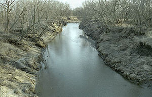
, in a heavily channelized steambed. It joins the Platte River 6 mi (9.7 km) east of St. Joseph.
Via the Platte, it is part of the watershed
Drainage basin
A drainage basin is an extent or an area of land where surface water from rain and melting snow or ice converges to a single point, usually the exit of the basin, where the waters join another waterbody, such as a river, lake, reservoir, estuary, wetland, sea, or ocean...
of the Missouri River
Missouri River
The Missouri River flows through the central United States, and is a tributary of the Mississippi River. It is the longest river in North America and drains the third largest area, though only the thirteenth largest by discharge. The Missouri's watershed encompasses most of the American Great...
. Much of the river's course has been straightened and channelized.