
.gif)
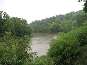
Platte River (Missouri)
Encyclopedia
Tributary
A tributary or affluent is a stream or river that flows into a main stem river or a lake. A tributary does not flow directly into a sea or ocean...
of the Missouri River
Missouri River
The Missouri River flows through the central United States, and is a tributary of the Mississippi River. It is the longest river in North America and drains the third largest area, though only the thirteenth largest by discharge. The Missouri's watershed encompasses most of the American Great...
, about 200 miles (321.9 km) long, in southwestern Iowa
Iowa
Iowa is a state located in the Midwestern United States, an area often referred to as the "American Heartland". It derives its name from the Ioway people, one of the many American Indian tribes that occupied the state at the time of European exploration. Iowa was a part of the French colony of New...
and northwestern Missouri
Missouri
Missouri is a US state located in the Midwestern United States, bordered by Iowa, Illinois, Kentucky, Tennessee, Arkansas, Oklahoma, Kansas and Nebraska. With a 2010 population of 5,988,927, Missouri is the 18th most populous state in the nation and the fifth most populous in the Midwest. It...
in the United States
United States
The United States of America is a federal constitutional republic comprising fifty states and a federal district...
. It is sometimes known as the Little Platte River to distinguish it from the larger Platte River
Platte River
The Platte River is a major river in the state of Nebraska and is about long. Measured to its farthest source via its tributary the North Platte River, it flows for over . The Platte River is a tributary of the Missouri River, which in turn is a tributary of the Mississippi River which flows to...
, also a tributary of the Missouri, in nearby Nebraska
Nebraska
Nebraska is a state on the Great Plains of the Midwestern United States. The state's capital is Lincoln and its largest city is Omaha, on the Missouri River....
; the Platte River of Missouri itself has a tributary known as the "Little Platte River".
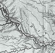
Course
The Platte River rises near CrestonCreston, Iowa
Creston is a city in and the county seat of Union County, Iowa, United States. The population was 7,597 at the 2000 census. McKinley Lake lies within a large, multi-purpose municipal park within the city limits, and three additional recreational lakes are located within seven miles of Creston:...
in Union County, Iowa and flows generally southwardly through Adams
Adams County, Iowa
-2010 census:The 2010 census recorded a population of 4,029 in the county, with a population density of . There were 2,010 housing units, of which 1,715 were occupied.-2000 census:...
, Ringgold
Ringgold County, Iowa
-2010 census:The 2010 census recorded a population of 5,131 in the county, with a population density of . There were 2,613 housing units, of which 2,047 were occupied.-2000 census:...
and Taylor
Taylor County, Iowa
-2010 census:The 2010 census recorded a population of 6,317 in the county, with a population density of . There were 3,107 housing units, of which 2,679 were occupied.-2000 census:...
Counties in Iowa; and Worth, Nodaway
Nodaway County, Missouri
Nodaway County is a county located in the U.S. state of Missouri. The county was organized in 1845 and named for the Nodaway River.As of 2010, the population was 23,370...
, Andrew
Andrew County, Missouri
-External links:* from University of Missouri Division of Special Collections, Archives, and Rare Books...
, Buchanan
Buchanan County, Missouri
Buchanan County is a county located in the U.S. state of Missouri. As of 2010, the population was 89,201. Its county seat is Saint Joseph. When originally formed in 1838, the county was named Roberts County, after settler Hiram Roberts; it was renamed in 1839 for James Buchanan, then a U.S....
and Platte
Platte County, Missouri
As of the census of 2000, there were 73,781 people, 29,278 households, and 20,231 families residing in the county. The population density was 176 people per square mile . There were 30,902 housing units at an average density of 74 per square mile...
Counties in Missouri. Along its course it passes the Iowa towns of Maloy
Maloy, Iowa
Maloy is a city in Ringgold County, Iowa, United States, along the Platte River. The population was 28 at the 2000 census.-History:Settlement of the western part of Ringgold County began in the 1850s. Maloy was platted in 1887, in the same year as the railroad arrived. Maloy was incorporated as a...
, Blockton
Blockton, Iowa
Blockton is a city in Taylor County, Iowa, United States. The population was 192 at the 2000 census.-Geography:Blockton's longitude and latitude coordinatesin decimal form are 40.615851, -94.476654...
and Athelstan
Athelstan, Iowa
Athelstan is a former city in Taylor County, Iowa, United States, along the Platte River, and is also majority owned by the Young family. The population was 18 at the 2000 census...
; and the Missouri towns of Sheridan
Sheridan, Missouri
Sheridan is a city in Worth County, Missouri, United States, near the Platte River. The population was 185 at the 2000 census, at which time it was a town.-Geography:Sheridan is located at ....
, Parnell
Parnell, Missouri
Parnell is a city in Nodaway County, Missouri, United States, near the Platte River. The population was 197 at the 2000 census.-Geography:Parnell is located at ....
, Ravenwood
Ravenwood, Missouri
Ravenwood is a city in Nodaway County, Missouri, United States, near the Platte River. The population was 448 at the 2000 census, at which time it was a town.-Geography:Ravenwood is located at ....
, Conception Junction
Conception Junction, Missouri
Conception Junction is a city in Nodaway County, Missouri, United States, near the Platte River. The population was 202 at the 2000 census, at which time it was a town.-Geography:...
, Guilford
Guilford, Missouri
Guilford is a village in Nodaway County, Missouri, United States, near the Platte River. The population was 87 at the 2000 census, at which time it was a town. It is served by the South Nodaway R-IV School District, and is home of the elementary school...
, Tracy
Tracy, Missouri
Tracy is a city in Platte County, Missouri, along the Platte River. The population was 213 as of the 2000 census.-Geography:Tracy is located at ....
, Platte City
Platte City, Missouri
Platte City is a city in Platte County, Missouri, along the Little Platte River. The population was 3,866 at the 2000 census. It is the county seat of Platte County.-Geography:Platte City is located at...
and Farley
Farley, Missouri
Farley is a village in Platte County, Missouri, U.S., along the Platte River. The population was 226 at the 2000 census.-Geography:Farley is located at .According to the United States Census Bureau, the village has a total area of , all of it land....
. The Platte flows into the Missouri River near Farley, downstream of Leavenworth, Kansas
Leavenworth, Kansas
Leavenworth is the largest city and county seat of Leavenworth County, in the U.S. state of Kansas and within the Kansas City, Missouri Metropolitan Area. Located in the northeast portion of the state, it is on the west bank of the Missouri River. As of the 2010 census, the city population was...
.
Several sections of the river's course have been straightened and channelized.
Tributaries
- Near its headwaters in Iowa the Platte collects minor branches known as the West Platte River, Middle Platte River, and East Platte River.
- In Buchanan County, Missouri, it collects the One Hundred and Two RiverOne Hundred and Two RiverThe One Hundred and Two River is a tributary of the Platte River of Missouri that is approximately long, in northwestern Missouri in the United States, with its source tributaries rising in southwestern Iowa....
and the Third Fork, which rises in Gentry CountyGentry County, MissouriAs of the census of 2000, there were 6,861 people, 2,747 households, and 1,884 families residing in the county. The population density was 14 people per square mile . There were 3,214 housing units at an average density of 6 per square mile...
and flows southwardly through DeKalb CountyDeKalb County, MissouriDeKalb County is a county located in the U.S. state of Missouri. As of 2010, the population is 12,892. The county was organized in 1845 and is named after the American Revolutionary War general Johann de Kalb. The county along with Buchanan and Andrew counties in Missouri and Doniphan County,...
, past Union StarUnion Star, MissouriUnion Star is a city in DeKalb County, Missouri, United States, along the Third Fork of the Platte River. The population was 433 at the 2000 census, at which time it was a town. It is part of the St. Joseph, MO–KS Metropolitan Statistical Area....
. The Third Fork collects the Little Third Fork, which flows southwardly through DeKalb and Buchanan Counties, past ClarksdaleClarksdale, MissouriClarksdale is a city in DeKalb County, Missouri, along the Little Third Fork of the Platte River. The population was 351 at the 2000 census. It is part of the St...
. - In Platte County, Missouri, it collects the Little Platte River, which rises in DeKalb County and flows south-southwestwardly through ClintonClinton County, MissouriAs of the census of 2000, there were 18,979 people, 7,152 households, and 5,299 families residing in the county. The population density was 45 people per square mile . There were 7,877 housing units at an average density of 19 per square mile...
and Clay Counties, past PlattsburgPlattsburg, MissouriPlattsburg is a city in Clinton County, Missouri, along the Little Platte River. The population was 2,354 at the 2000 census. It is the county seat of Clinton County.- History :...
and SmithvilleSmithville, MissouriSmithville is a city in Clay and Platte counties in the U.S. state of Missouri, along the Little Platte River. The population was 5,514 at the 2000 census.-Geography:Smithville is located at , primarily in Clay County....
. Near Smithville, a U.S. Army Corps of Engineers damDamA dam is a barrier that impounds water or underground streams. Dams generally serve the primary purpose of retaining water, while other structures such as floodgates or levees are used to manage or prevent water flow into specific land regions. Hydropower and pumped-storage hydroelectricity are...
causes the Little Platte River to form Smithville LakeSmithville LakeSmithville Lake is a reservoir on the Little Platte branch of the Platte River near Smithville, Missouri.The lake was built and is administered by the Kansas City office of the United States Army Corps of Engineers...
.
History
Main article: Platte PurchasePlatte Purchase
The Platte Purchase was a land acquisition in 1836 by the United States government from Native American tribes all of which was east bank lands along the Missouri River that added to the northwest corner of the state of Missouri. The area acquired is almost as large as the states of Delaware and...
When Missouri entered the union in 1821, the western border of Missouri from Arkansas to Iowa was based on the confluence of the Kansas River
Kansas River
The Kansas River is a river in northeastern Kansas in the United States. It is the southwestern-most part of the Missouri River drainage, which is in turn the northwestern-most portion of the extensive Mississippi River drainage. Its name come from the Kanza people who once inhabited the area...
and Missouri River
Missouri River
The Missouri River flows through the central United States, and is a tributary of the Mississippi River. It is the longest river in North America and drains the third largest area, though only the thirteenth largest by discharge. The Missouri's watershed encompasses most of the American Great...
in the West Bottoms
West Bottoms
The West Bottoms is an industrial area immediately to the west of downtown Kansas City, Missouri at the confluence of the Missouri River and the Kansas River. The area is one of the oldest areas of the city....
in Kansas City. Land in what is now the northwest Missouri was deeded to the Ioway, Sac
Sac (tribe)
The Sacs or Sauks are a group of Native Americans of the Eastern Woodlands culture group. Their autonym is The Sacs or Sauks are a group of Native Americans of the Eastern Woodlands culture group. Their autonym is The Sacs or Sauks are a group of Native Americans of the Eastern Woodlands culture...
and Fox tribes.
However, settlers (most notably Joseph Robidoux
Joseph Robidoux
Joseph Robidoux III established the Blacksnake Hills Trading Post that eventually became St. Joseph, Missouri.-Biography:...
in St. Joseph, Missouri) began encroaching on the land. Further settlers in northern Missouri were upset about being cut off from the Missouri.
Platte Purchase
The Platte Purchase was a land acquisition in 1836 by the United States government from Native American tribes all of which was east bank lands along the Missouri River that added to the northwest corner of the state of Missouri. The area acquired is almost as large as the states of Delaware and...
was named for the river was ratified in 1837 and the tribes were paid $7,500 for an area about the combined size of Delaware and Rhode Island. The land was then annexed to Missouri.
In 1838 settlers used the river (and the Nodaway River
Nodaway River
The Nodaway River is a river in southwest Iowa and northwest Missouri.-Etymology:The river's name first appears in the journal of Lewis and Clark, who camped at the mouth of the river on July 8, 1804, but who provide no derivation of the name. There exist several proposed etymologies...
) to reach the heart of the newly available land. The Platte River is not used for transportation in modern times although Missouri River steam boats did call on Tracy, Missouri
Tracy, Missouri
Tracy is a city in Platte County, Missouri, along the Platte River. The population was 213 as of the 2000 census.-Geography:Tracy is located at ....
.
On September 3, 1861, bushwhackers burned a bridge over the river at St. Joseph, Missouri, derailing a Hannibal & St. Joseph Railroad train killing between 17 and 20 and injuring 200 in one of the worst attacks on a passenger train in the Platte Bridge Railroad Tragedy
Platte Bridge Railroad Tragedy
The Platte Bridge Railroad Tragedy was a bushwhacker attack on the Hannibal and St. Joseph Railroad during the American Civil War on September 3, 1861, in which the train derailed on a bridge over the Platte River east of St. Joseph, Missouri, killing between 17 and 20 and injuring 100...
during the American Civil War
American Civil War
The American Civil War was a civil war fought in the United States of America. In response to the election of Abraham Lincoln as President of the United States, 11 southern slave states declared their secession from the United States and formed the Confederate States of America ; the other 25...
. Union forces were to burn Platte City, Missouri
Platte City, Missouri
Platte City is a city in Platte County, Missouri, along the Little Platte River. The population was 3,866 at the 2000 census. It is the county seat of Platte County.-Geography:Platte City is located at...
in 1861 and 1864 as they tried to force the residents to give up Silas M. Gordon
Silas M. Gordon
Silas M. Gordon was an anti-union bushwhacker who indirectly caused Platte City, Missouri, to be burned twice by forces during the American Civil War...
, the suspected ringleader of the attack.
The river is the biggest river in the Platte Purchase area and it flows through the Kansas City Metropolitan Area
Kansas City Metropolitan Area
The Kansas City Metropolitan Area is a fifteen-county metropolitan area that is anchored by Kansas City, Missouri and is bisected by the border between the states of Missouri and Kansas. As of the 2010 Census, the metropolitan area has a population of 2,035,334. The metropolitan area is the...
as well as St. Joseph, Missouri metropolitan area. The river is an eighth order
Strahler Stream Order
In mathematics, the Strahler number or Horton–Strahler number of a mathematical tree is a numerical measure of its branching complexity....
river.
Average flow at mile 25.1 is 1,925 cubic feet second (54.5 m³/s). The highest flow was 37,800 ft³/s (1070 m³/s) during the Great Flood of 1993
Great Flood of 1993
The Great Mississippi and Missouri Rivers Flood of 1993 occurred in the American Midwest, along the Mississippi and Missouri rivers and their tributaries, from April to October 1993. The flood was among the most costly and devastating to ever occur in the United States, with $15 billion in damages...
on July 26, 1993. The lowest flow was 12 ft³/s (0.33 m³/s) during a drought in August 1989.