

Old Sodbury
Encyclopedia
River Frome, Bristol
The River Frome is a river, approximately long, which rises in Dodington Park, South Gloucestershire, and flows in a south westerly direction through Bristol, joining the former course of the river Avon in Bristol's Floating Harbour. The mean flow at Frenchay is The name Frome is shared with...
just below and to the west of the Cotswold escarpment and to the east of Chipping Sodbury
Chipping Sodbury
Chipping Sodbury is a market town in the county of South Gloucestershire, south-west England, founded in the 12th century by William Crassus . The villages of Old Sodbury and Little Sodbury are nearby...
and Yate
Yate
Yate is a town in South Gloucestershire, England, at the southwest extremity of the Cotswold Hills, 12 miles northeast of the city of Bristol. At the 2001 census the population was 21,789. The town of Chipping Sodbury is continuous with Yate to the east...
in South Gloucestershire
South Gloucestershire
South Gloucestershire is a unitary district in the ceremonial county of Gloucestershire, in South West England.-History:The district was created in 1996, when the county of Avon was abolished, by the merger of former area of the districts of Kingswood and Northavon...
, England
England
England is a country that is part of the United Kingdom. It shares land borders with Scotland to the north and Wales to the west; the Irish Sea is to the north west, the Celtic Sea to the south west, with the North Sea to the east and the English Channel to the south separating it from continental...
. The village extends from Chipping Sodbury in the West to the Cotswold Edge in the East and is on the Cotswold Way
Cotswold Way
The Cotswold Way is a long-distance footpath, running along the Cotswold Edge escarpment of the Cotswold Hills in England. It was officially inaugurated as a National Trail on 24 May 2007 and several new rights of way have been created.-History:...
. The Badminton Road (A432
A432 road
The A432 is a road running from Bristol to Old Sodbury. It starts near Lawrence Hill in Bristol and passes through Eastville, Fishponds, Downend, Coalpit Heath, Yate and Chipping Sodbury before terminating at a junction with the A46 just to the east of Old Sodbury...
) winds eastwards through the village, up to its junction with the A46
A46 road
The A46 is an A road in England. It starts east of Bath, Somerset and ends in Cleethorpes, North East Lincolnshire, but it does not form a continuous route. Large portions of the old road have been lost, bypassed, or replaced by motorway development...
, which broadly follows the line of the Fosseway and runs along the top of the Cotswold escarpment (from Bath to Stroud
Stroud
Stroud a town and civil parish in the county of Gloucestershire, England.Stroud may also refer to:*Stroud, New South Wales, Australia*Stroud, Ontario, Canada*Stroud , Gloucestershire, UK*Stroud...
).
The village lies on an old coaching route, and is much more ancient than its westerly neighbour, Chipping Sodbury
Chipping Sodbury
Chipping Sodbury is a market town in the county of South Gloucestershire, south-west England, founded in the 12th century by William Crassus . The villages of Old Sodbury and Little Sodbury are nearby...
: hence the name 'Old' Sodbury.
Name and fort
The name of the village is recorded in Anglo-SaxonOld English language
Old English or Anglo-Saxon is an early form of the English language that was spoken and written by the Anglo-Saxons and their descendants in parts of what are now England and southeastern Scotland between at least the mid-5th century and the mid-12th century...
(in the dative case) as Soppanbyrig = "Soppa's fort" and in Domesday Book
Domesday Book
Domesday Book , now held at The National Archives, Kew, Richmond upon Thames in South West London, is the record of the great survey of much of England and parts of Wales completed in 1086...
as Sopeberie. The name may refer to the Iron Age hill fort just to the north-east of the village. The fort, perched on the edge of the Cotswold
Cotswold
The Cotswolds are a range of hills in central England that give their name to:*Cotswold *Cotswold *Cotswold Chase, a horse race*Cotswold Games, annual games in Chipping Campden, Gloucestershire...
escarpment, is enclosed on three sides by two parallel earthworks, and is open to the west, commanding an impressive view of the Frome Valley, Severn Vale and the Welsh mountains. The earth walls enclose an area of 11 acres (44,515.5 m²), and are usually kept mown by the local farmer (the fort is in private hands, but accessible). The fort can be reached by footpath from the A46 road
A46 road
The A46 is an A road in England. It starts east of Bath, Somerset and ends in Cleethorpes, North East Lincolnshire, but it does not form a continuous route. Large portions of the old road have been lost, bypassed, or replaced by motorway development...
, and through the village from below via the Cotswold Way. Below the fort are a group of ancient pillow mounds which are supposed to have been created by people who hoped rabbits would develop warrens there - providing a source of meat.
The Romans
Roman Empire
The Roman Empire was the post-Republican period of the ancient Roman civilization, characterised by an autocratic form of government and large territorial holdings in Europe and around the Mediterranean....
strengthened the fort for use as a camp to support their western frontier. In AD 577
577
Year 577 was a common year starting on Friday of the Julian calendar. The denomination 577 for this year has been used since the early medieval period, when the Anno Domini calendar era became the prevalent method in Europe for naming years.- Europe :* Battle of Deorham: The Anglo-Saxons under...
the Saxon army used the fort as a camp before the battle of Dyrham, a few miles to the south. King Edward IV camped here in 1471 before attacking the army of Margaret of Anjou
Margaret of Anjou
Margaret of Anjou was the wife of King Henry VI of England. As such, she was Queen consort of England from 1445 to 1461 and again from 1470 to 1471; and Queen consort of France from 1445 to 1453...
at the Battle of Tewkesbury
Battle of Tewkesbury
The Battle of Tewkesbury, which took place on 4 May 1471, was one of the decisive battles of the Wars of the Roses. The forces loyal to the House of Lancaster were completely defeated by those of the rival House of York under their monarch, King Edward IV...
.
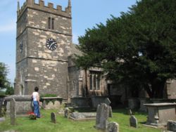
Church
The Church of Saint John the Baptist is late Norman or Transitional, and is some 900 years old. It has two effigies of knights: one is late 14th century, carved in wood; and the other is dated to 1240, carved in stone, featuring a very large shield. These two are considered to have been lords of the local manor.In the churchyard at Old Sodbury are a number of old bale-tombs; these were tombs for rich merchants. Some of the gravestones date back to the early 19th century. Just outside the churchyard on the hillside is a topograph (a large stone with an engraving), installed to commemorate the second millennium, that shows Old Sodbury in relation to its geographical surroundings.
Other buildings
There are two primary schools (Old Sodbury CofE Primary School, and the privately run Overndale School), two hotels, and two pubs, The Bell Hotel and The Dog Inn. The village has a petrol station, a football pitch and a playground, but sadly no longer a post office since the last round of closures in 2008, although the village shop still survives in the same premises on the Badminton Road. The historic Cross Hands Hotel stands on the North-Eastern corner of the A46 crossroads, and there is a farm shop (Cotswold Edge) opposite the hotel.There is a crenellated tower on the escarpment immediately above and to the East of the village, resembling a rook chesspiece, visible from the main road, that performs the function of a ventilation shaft (the first of six) for the Chipping Sodbury Tunnel
Chipping Sodbury Tunnel
Chipping Sodbury Tunnel sits on the South Wales Main Line. It was constructed around 1900 for the South Wales and Bristol Direct Railway and runs some 2½ miles west of Badminton railway station and Chipping Sodbury Yard....
, on the main railway line from South Wales, via Bristol Parkway to London Paddington). These shafts were designed by Isambard Kingdom Brunel
Isambard Kingdom Brunel
Isambard Kingdom Brunel, FRS , was a British civil engineer who built bridges and dockyards including the construction of the first major British railway, the Great Western Railway; a series of steamships, including the first propeller-driven transatlantic steamship; and numerous important bridges...
for the Great Western Railway
Great Western Railway
The Great Western Railway was a British railway company that linked London with the south-west and west of England and most of Wales. It was founded in 1833, received its enabling Act of Parliament in 1835 and ran its first trains in 1838...
, which runs through the village and under the hill above it. The line originally ran between Chipping Sodbury
Chipping Sodbury railway station
Chipping Sodbury railway station was a railway station on the South Wales Main Line serving the town of Chipping Sodbury in Gloucestershire.The station opened on 1 July 1903, and closed on 3 April 1961.- External links :*...
and Badminton
Badminton railway station
Badminton railway station is a closed railway station in Gloucestershire, England. As well as Badminton it served the village of Acton Turville.-History:...
stations, which were closed around the time of the Beeching axe
Beeching Axe
The Beeching Axe or the Beeching Cuts are informal names for the British Government's attempt in the 1960s to reduce the cost of running British Railways, the nationalised railway system in the United Kingdom. The name is that of the main author of The Reshaping of British Railways, Dr Richard...
. Now, the nearest station is Yate
Yate railway station
Yate railway station serves the town of Yate in South Gloucestershire, in south west England. The station is located on the main Bristol to Birmingham line between Bristol Parkway and Cam & Dursley, and is operated by First Great Western....
on the main line from Bristol
Bristol
Bristol is a city, unitary authority area and ceremonial county in South West England, with an estimated population of 433,100 for the unitary authority in 2009, and a surrounding Larger Urban Zone with an estimated 1,070,000 residents in 2007...
to Birmingham
Birmingham
Birmingham is a city and metropolitan borough in the West Midlands of England. It is the most populous British city outside the capital London, with a population of 1,036,900 , and lies at the heart of the West Midlands conurbation, the second most populous urban area in the United Kingdom with a...
, which intersects the Great Western Railway to the South of Yate.
Lyegrove House is 17th century in origin, altered in the 19th and 20th centuries. The Lodge is Gothic of 1835 by Charles Dyer
Charles Dyer
Charles Dyer was an architect based in London who designed many buildings in and around Bristol.-Some buildings of Charles Dyer:* St Pauls' Church, Bedminster * Engineers House, Bristol 1831...
of Bristol.
External links
- Sodbury Players - local amateur dramatics group in the Yate and Chipping Sodbury Area