

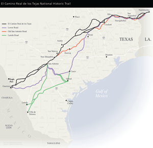
Old San Antonio Road
Encyclopedia
United States
The United States of America is a federal constitutional republic comprising fifty states and a federal district...
states of Texas
Texas
Texas is the second largest U.S. state by both area and population, and the largest state by area in the contiguous United States.The name, based on the Caddo word "Tejas" meaning "friends" or "allies", was applied by the Spanish to the Caddo themselves and to the region of their settlement in...
and Louisiana
Louisiana
Louisiana is a state located in the southern region of the United States of America. Its capital is Baton Rouge and largest city is New Orleans. Louisiana is the only state in the U.S. with political subdivisions termed parishes, which are local governments equivalent to counties...
. Parts of it were based on traditional Native American trails. Its Texas
Texas
Texas is the second largest U.S. state by both area and population, and the largest state by area in the contiguous United States.The name, based on the Caddo word "Tejas" meaning "friends" or "allies", was applied by the Spanish to the Caddo themselves and to the region of their settlement in...
terminus was about 35 miles (56.3 km) southeast of Eagle Pass
Eagle Pass, Texas
Eagle Pass is a city in and the county seat of Maverick County The population was 27,183 as of the 2010 census.Eagle Pass borders the city of Piedras Negras, Coahuila, Mexico, which is to the southwest and across the Rio Grande. The Eagle Pass-Piedras Negras Metropolitan Area is one of six...
at the Rio Grande
Rio Grande
The Rio Grande is a river that flows from southwestern Colorado in the United States to the Gulf of Mexico. Along the way it forms part of the Mexico – United States border. Its length varies as its course changes...
in Maverick County
Maverick County, Texas
Maverick County is a county located in the U.S. state of Texas. In 2000, its population was 47,297. Its county seat is Eagle Pass. Maverick County is named for Samuel Maverick, cattleman and state legislator....
, and its northern terminus was at Natchitoches, Louisiana
Natchitoches, Louisiana
Natchitoches is a city in and the parish seat of Natchitoches Parish, Louisiana, United States. Established in 1714 by Louis Juchereau de St. Denis as part of French Louisiana, the community was named after the Natchitoches Indian tribe. The City of Natchitoches was first incorporated on February...
. The road continued from Texas through Monclova to Mexico City
Mexico City
Mexico City is the Federal District , capital of Mexico and seat of the federal powers of the Mexican Union. It is a federal entity within Mexico which is not part of any one of the 31 Mexican states but belongs to the federation as a whole...
.
Route
Louisiana Highway 6Louisiana Highway 6
Louisiana Highway 6 is a state highway in Louisiana. It spans and serves Sabine Parish and Natchitoches Parish.-Route description:...
mostly runs alongside the Old San Antonio Road for the entirety of its route through that state from Natchitoches
Natchitoches, Louisiana
Natchitoches is a city in and the parish seat of Natchitoches Parish, Louisiana, United States. Established in 1714 by Louis Juchereau de St. Denis as part of French Louisiana, the community was named after the Natchitoches Indian tribe. The City of Natchitoches was first incorporated on February...
to west of Many
Many, Louisiana
Many is a town in and the parish seat of Sabine Parish, Louisiana, United States. The population was 2,889 at the 2000 census. The town was named for John B. Many, the commander of nearby Fort Jesup.-History:...
. State Highway 21 follows the old road to Midway
Midway, Texas
Midway is a city in Madison County, Texas, United States. at the junction of the La Bahía Road and the Old San Antonio Road in northeastern Madison County.-Geography:Midway is located at ....
, Texas, then State Highway OSR
State Highway OSR (Texas)
State Highway OSR is a state highway in the U.S. state of Texas. The route is the section of the Old San Antonio Road in east central Texas that is maintaned by the Texas Department of Transportation...
(for Old San Antonio Road) follows it around Bryan
Bryan, Texas
Bryan is a city in Brazos County, Texas, United States. As of the 2010 census, the city had a total population of 76,201. It is the county seat of Brazos County and is located in the heart of the Brazos Valley . It shares its border with the city of College Station, which lies to its south...
and College Station
College Station, Texas
College Station is a city in Brazos County, Texas, situated in East Central Texas in the heart of the Brazos Valley. The city is located within the most populated region of Texas, near three of the 10 largest cities in the United States - Houston, Dallas, and San Antonio...
, and back to Highway 21 to the eastern outskirts of San Marcos
San Marcos, Texas
San Marcos is a city in the U.S. state of Texas, and is the seat of Hays County. Located within the metropolitan area, the city is located on the Interstate 35 corridor—between Austin and San Antonio....
. South of San Marcos, the road follows the Old Bastrop Road until it intersects with I-35
Interstate 35
Interstate 35 is a north–south Interstate Highway in the central United States. I-35 stretches from Laredo, Texas, on the U.S.-Mexico border to Duluth, Minnesota, at Minnesota Highway 61 and 26th Avenue East. Many interstates used to have splits or spurs indicated with suffixed letters , but I-35...
. The road leaves the Interstate at New Braunfels
New Braunfels, Texas
New Braunfels is a city in Comal and Guadalupe counties in the U.S. state of Texas that is a principal city of the metropolitan area. Braunfels means "brown rock" in German; the city is named for Braunfels, in Germany. The city's population was 57,740 as of the 2010 census, up 58% from the 2000...
and follows Solms road, then Nacogdoches Road, then Mission Road through San Antonio
San Antonio, Texas
San Antonio is the seventh-largest city in the United States of America and the second-largest city within the state of Texas, with a population of 1.33 million. Located in the American Southwest and the south–central part of Texas, the city serves as the seat of Bexar County. In 2011,...
. South of San Antonio, the road follows Old Pleasanton Road, then varying local and county roads and merges with State Highway 97
State Highway 97 (Texas)
State Highway 97 or SH 97 is a state highway running from Cotulla to Waelder in the U.S. state of Texas.-History:In 1926, SH 97 was originally planned as a route from Rio Grande City via Hebbronville and Tilden to end at Pleasanton,...
to Cotulla
Cotulla, Texas
Cotulla is a city in and the county seat of La Salle County, Texas, United States. The population was 3,614 at the 2000 census.-History:In 1868, Polish immigrant Joseph Cotulla arrived in La Salle County and eventually established a large ranching operation...
. The road crosses private property and then follows State Highway 133 to Catarina
Catarina, Texas
Catarina is a census-designated place in Dimmit County, Texas, United States. The population was 135 at the 2000 census. The community has a U.S...
. After Catarina, the road is on private property.
History
In 1690, SpanishSpain
Spain , officially the Kingdom of Spain languages]] under the European Charter for Regional or Minority Languages. In each of these, Spain's official name is as follows:;;;;;;), is a country and member state of the European Union located in southwestern Europe on the Iberian Peninsula...
explorer Alonso de León
Alonso De León
Alonso de León wasexplorer and governor, who led several expeditions into the area that is now northeastern Mexico and southern Texas.-Early life:...
, following various Indian
Indigenous peoples of the Americas
The indigenous peoples of the Americas are the pre-Columbian inhabitants of North and South America, their descendants and other ethnic groups who are identified with those peoples. Indigenous peoples are known in Canada as Aboriginal peoples, and in the United States as Native Americans...
and buffalo
American Bison
The American bison , also commonly known as the American buffalo, is a North American species of bison that once roamed the grasslands of North America in massive herds...
trails, crossed the Rio Grande
Rio Grande
The Rio Grande is a river that flows from southwestern Colorado in the United States to the Gulf of Mexico. Along the way it forms part of the Mexico – United States border. Its length varies as its course changes...
on his way to East Texas
East Texas
East Texas is a distinct geographic and ecological area in the U.S. state of Texas.According to the Handbook of Texas, the East Texas area "may be separated from the rest of Texas roughly by a line extending from the Red River in north central Lamar County southwestward to east central Limestone...
to establish mission
Mission (Christian)
Christian missionary activities often involve sending individuals and groups , to foreign countries and to places in their own homeland. This has frequently involved not only evangelization , but also humanitarian work, especially among the poor and disadvantaged...
s, effectively blazing the Old San Antonio Road. In 1691 (the generally accepted "birth year" of the road), Domingo Terán de los Ríos
Domingo Terán de los Ríos
Domingo Terán de los Ríos served as the first governor of Spanish Texas from 1691 to 1692.-Previous service:Terán served the Spanish crown in Peru for two decades. He came to Mexico in 1681, and was governor of the province of Sonora y Sinaloa for approximately five years...
took additional missionaries to East Texas following much the same course as traveled by De León. In 1693, Gregorio de Salinas Varona further defined the course of the road while bringing relief supplies from Monclova.
The Old San Antonio Road was not a single road, but a network of trails with different routes at different times. The trail's path was dictated by things as diverse as weather and Indian threats.
During the time that Texas was a Spanish, then Mexican, state, the road was used as a major thoroughfare between Mexico City and East Texas
East Texas
East Texas is a distinct geographic and ecological area in the U.S. state of Texas.According to the Handbook of Texas, the East Texas area "may be separated from the rest of Texas roughly by a line extending from the Red River in north central Lamar County southwestward to east central Limestone...
. With Texas independence, however, trade between Mexico and Texas waned, while Mexico's trade with the United States began to increase. The old route from San Antonio to Louisiana, now called the Camino Arriba, was still a vital link for Texans to the United States. During the 1860s, the old road had a brief revival as a supply line from the Texas interior to the Confederacy
Confederate States of America
The Confederate States of America was a government set up from 1861 to 1865 by 11 Southern slave states of the United States of America that had declared their secession from the U.S...
, and for the flow of cotton to Mexico
Mexico
The United Mexican States , commonly known as Mexico , is a federal constitutional republic in North America. It is bordered on the north by the United States; on the south and west by the Pacific Ocean; on the southeast by Guatemala, Belize, and the Caribbean Sea; and on the east by the Gulf of...
as a means to circumvent the ever-tightening Union blockade
Union blockade
The Union Blockade, or the Blockade of the South, took place between 1861 and 1865, during the American Civil War, when the Union Navy maintained a strenuous effort on the Atlantic and Gulf Coast of the Confederate States of America designed to prevent the passage of trade goods, supplies, and arms...
.
After the Civil War
American Civil War
The American Civil War was a civil war fought in the United States of America. In response to the election of Abraham Lincoln as President of the United States, 11 southern slave states declared their secession from the United States and formed the Confederate States of America ; the other 25...
, the name Camino Arriba faded and the road was called the Old San Antonio Road. By the 1870s, with the coming of the railroad, the roadway between San Antonio and Mexico, had all but disappeared. It was then called the Lower Presidio Road.
Preservation
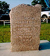
In 1915, the State of Texas and the Daughters of the American Revolution
Daughters of the American Revolution
The Daughters of the American Revolution is a lineage-based membership organization for women who are descended from a person involved in United States' independence....
(DAR) funded a project to place pink granite markers at approximately 5 miles (8 km) intervals along the route of the Old San Antonio Road. V.N. Zively, a professional surveyor, mapped the routing in 1915 and 1916 and placed an oak
Oak
An oak is a tree or shrub in the genus Quercus , of which about 600 species exist. "Oak" may also appear in the names of species in related genera, notably Lithocarpus...
post at each marker site. Inscribed granite markers were installed later, and the Texas DAR presented the markers to the State of Texas in a ceremony in San Antonio on March 2, 1918.
The State of Texas took this routing and marked the remaining county roads as State Highway OSR. Originally, the whole route from the Sabine River to San Marcos carried this designation, but it has since been reduced to a short bypass around Bryan
Bryan, Texas
Bryan is a city in Brazos County, Texas, United States. As of the 2010 census, the city had a total population of 76,201. It is the county seat of Brazos County and is located in the heart of the Brazos Valley . It shares its border with the city of College Station, which lies to its south...
.
As of February 2006, all but nine of the 123 markers were surviving, but many were moved from their original locations as the route of the road was straightened by new highway construction. In deep South Texas
South Texas
South Texas is a region of the U.S. state of Texas that lies roughly south of and including San Antonio. The southern and western boundary is the Rio Grande River, and to the east it is the Gulf of Mexico. The population of this region is about 3.7 million. The southern portion of this region is...
, many of the markers are now on private ranches. (See List of Old San Antonio Road DAR Markers.)
In 1929, the Texas legislature designated the Zivley version of the Old San Antonio Road as one of the historic trails of Texas. Later research by the Old San Antonio Road Preservation Commission determined that the Zively route is just one of no fewer than five different main routes that were used at various times.
In 1989, the Texas Legislature
Texas Legislature
The Legislature of the state of Texas is the state legislature of the U.S. state of Texas. The legislature is a bicameral body composed of a 31-member Senate and a 150-member House of Representatives. The Legislature meets at the Capitol in Austin...
created the Old San Antonio Road Preservation Commission to coordinate a yearlong observance in 1991 of the 300th anniversary of the road and encourage tourism along the route. The member agencies of the commission—The Texas Historical Commission, the Texas Department of Transportation, Texas Parks and Wildlife, and the Department of Commerce—promoted the road and constructed a series of information panels to be placed along the route. The commission ceased operations in July, 1993.
On October 18, 2004, President Bush
George W. Bush
George Walker Bush is an American politician who served as the 43rd President of the United States, from 2001 to 2009. Before that, he was the 46th Governor of Texas, having served from 1995 to 2000....
signed a bill designating The El Camino Real de Los Tejas, of which the Old San Antonio Road is part, a National Historic Trail
National Historic Trail
National Historic Trail is a designation for a protected area in the United States containing historic trails and surrounding areas. They are part of the National Trails System....
. The Texas Legislature
Texas Legislature
The Legislature of the state of Texas is the state legislature of the U.S. state of Texas. The legislature is a bicameral body composed of a 31-member Senate and a 150-member House of Representatives. The Legislature meets at the Capitol in Austin...
is considering a bill that would give the Texas Historical Commission authority to oversee the development and administration of El Camino Real de los Tejas National Historic Trail in conjunction with the National Park Service
National Park Service
The National Park Service is the U.S. federal agency that manages all national parks, many national monuments, and other conservation and historical properties with various title designations...
.
U.S. cities along the route
- Natchitoches, LouisianaNatchitoches, LouisianaNatchitoches is a city in and the parish seat of Natchitoches Parish, Louisiana, United States. Established in 1714 by Louis Juchereau de St. Denis as part of French Louisiana, the community was named after the Natchitoches Indian tribe. The City of Natchitoches was first incorporated on February...
- Many, LouisianaMany, LouisianaMany is a town in and the parish seat of Sabine Parish, Louisiana, United States. The population was 2,889 at the 2000 census. The town was named for John B. Many, the commander of nearby Fort Jesup.-History:...
- Nacogdoches, TexasNacogdoches, TexasNacogdoches is a city in Nacogdoches County, Texas, in the United States. The 2010 census recorded the city's population to be 32,996. It is the county seat of Nacogdoches County and is situated in East Texas. Nacogdoches is a sister city of Natchitoches, Louisiana.Nacogdoches is the home of...
- Crockett, TexasCrockett, TexasCrockett is a city in Houston County, Texas, in the United States. As of the 2000 census, the city population was 7,141. It is the county seat of Houston County.- History :...
- Caldwell, TexasCaldwell, TexasCaldwell is a city in Burleson County, Texas, United States. The population was 3,449 at the 2000 census. It is the county seat of Burleson County. It is part of the Bryan-College Station metropolitan area....
- Bastrop, TexasBastrop, Texas-Demographics:As of the census of 2000, there are 5340 people in Bastrop, organized into 2034 households and 1336 families. The population density is 734.8 people per square mile . There are 2,239 housing units at an average density of 308.1 per square mile...
- San Marcos, TexasSan Marcos, TexasSan Marcos is a city in the U.S. state of Texas, and is the seat of Hays County. Located within the metropolitan area, the city is located on the Interstate 35 corridor—between Austin and San Antonio....
- New Braunfels, TexasNew Braunfels, TexasNew Braunfels is a city in Comal and Guadalupe counties in the U.S. state of Texas that is a principal city of the metropolitan area. Braunfels means "brown rock" in German; the city is named for Braunfels, in Germany. The city's population was 57,740 as of the 2010 census, up 58% from the 2000...
- San Antonio, TexasSan Antonio, TexasSan Antonio is the seventh-largest city in the United States of America and the second-largest city within the state of Texas, with a population of 1.33 million. Located in the American Southwest and the south–central part of Texas, the city serves as the seat of Bexar County. In 2011,...
- Cotulla, TexasCotulla, TexasCotulla is a city in and the county seat of La Salle County, Texas, United States. The population was 3,614 at the 2000 census.-History:In 1868, Polish immigrant Joseph Cotulla arrived in La Salle County and eventually established a large ranching operation...