

List of Old San Antonio Road DAR Markers
Encyclopedia
World Geodetic System
The World Geodetic System is a standard for use in cartography, geodesy, and navigation. It comprises a standard coordinate frame for the Earth, a standard spheroidal reference surface for raw altitude data, and a gravitational equipotential surface that defines the nominal sea level.The latest...
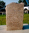
)) of the granite
Granite
Granite is a common and widely occurring type of intrusive, felsic, igneous rock. Granite usually has a medium- to coarse-grained texture. Occasionally some individual crystals are larger than the groundmass, in which case the texture is known as porphyritic. A granitic rock with a porphyritic...
markers placed by the Texas Society Daughters of the American Revolution
Daughters of the American Revolution
The Daughters of the American Revolution is a lineage-based membership organization for women who are descended from a person involved in United States' independence....
that designate one of the recognized main routes of the Old San Antonio Road
Old San Antonio Road
The Old San Antonio Road was a historic roadway located in the U.S. states of Texas and Louisiana. Parts of it were based on traditional Native American trails. Its Texas terminus was about southeast of Eagle Pass at the Rio Grande in Maverick County, and its northern terminus was at...
through Texas as surveyed in 1915 and placed in 1918. There were never any markers numbered 103-107 because of a numbering error by the surveyor.
As of February 2006, all but nine of the 123 markers were known to still exist. Some of the stones have been moved from their original 1918 locations to accommodate highway construction, ranching operations, etc.
| Marker # | Latitude | Longitude | County | Date last documented |
| 1 | unknown | unknown | Sabine County | 1995 (est.) |
| 2 | unknown | unknown | Sabine County | 1995 (est.) |
| 3 | unknown | unknown | Sabine County | 1995 (est.) |
| 4 | unknown | unknown | Sabine County | 1918 |
| 5 | unknown | unknown | Sabine County | 1918 |
| 6 | unknown | unknown | San Augustine County San Augustine County, Texas As of the census of 2000, there were 8,946 people, 3,575 households, and 2,520 families residing in the county. The population density was 17 people per square mile . There were 5,356 housing units at an average density of 10 per square mile... |
1995 (est.) |
| 7 | unknown | unknown | San Augustine County San Augustine County, Texas As of the census of 2000, there were 8,946 people, 3,575 households, and 2,520 families residing in the county. The population density was 17 people per square mile . There were 5,356 housing units at an average density of 10 per square mile... |
1995 (est.) |
| 8 | unknown | unknown | San Augustine County San Augustine County, Texas As of the census of 2000, there were 8,946 people, 3,575 households, and 2,520 families residing in the county. The population density was 17 people per square mile . There were 5,356 housing units at an average density of 10 per square mile... |
1995 (est.) |
| 9 | unknown | unknown | San Augustine County San Augustine County, Texas As of the census of 2000, there were 8,946 people, 3,575 households, and 2,520 families residing in the county. The population density was 17 people per square mile . There were 5,356 housing units at an average density of 10 per square mile... |
1995 (est.) |
| 10 | unknown | unknown | Nacogdoches County Nacogdoches County, Texas As of the census of 2000, there were 59,203 people, 22,006 households, and 14,039 families residing in the county. The population density was 62 people per square mile . There were 25,051 housing units at an average density of 26 per square mile... |
1995 (est.) |
| 11 | unknown | unknown | Nacogdoches County Nacogdoches County, Texas As of the census of 2000, there were 59,203 people, 22,006 households, and 14,039 families residing in the county. The population density was 62 people per square mile . There were 25,051 housing units at an average density of 26 per square mile... |
1918 |
| 12 | unknown | unknown | Nacogdoches County Nacogdoches County, Texas As of the census of 2000, there were 59,203 people, 22,006 households, and 14,039 families residing in the county. The population density was 62 people per square mile . There were 25,051 housing units at an average density of 26 per square mile... |
1918 |
| 13 | unknown | unknown | Nacogdoches County Nacogdoches County, Texas As of the census of 2000, there were 59,203 people, 22,006 households, and 14,039 families residing in the county. The population density was 62 people per square mile . There were 25,051 housing units at an average density of 26 per square mile... |
1918 |
| 14 | unknown | unknown | Nacogdoches County Nacogdoches County, Texas As of the census of 2000, there were 59,203 people, 22,006 households, and 14,039 families residing in the county. The population density was 62 people per square mile . There were 25,051 housing units at an average density of 26 per square mile... |
1995 (est.) |
| 15 | unknown | unknown | Nacogdoches County Nacogdoches County, Texas As of the census of 2000, there were 59,203 people, 22,006 households, and 14,039 families residing in the county. The population density was 62 people per square mile . There were 25,051 housing units at an average density of 26 per square mile... |
1995 (est.) |
| 16 | unknown | unknown | Nacogdoches County Nacogdoches County, Texas As of the census of 2000, there were 59,203 people, 22,006 households, and 14,039 families residing in the county. The population density was 62 people per square mile . There were 25,051 housing units at an average density of 26 per square mile... |
1918 |
| 17 | unknown | unknown | Nacogdoches County Nacogdoches County, Texas As of the census of 2000, there were 59,203 people, 22,006 households, and 14,039 families residing in the county. The population density was 62 people per square mile . There were 25,051 housing units at an average density of 26 per square mile... |
1918 |
| 18 | unknown | unknown | Nacogdoches County Nacogdoches County, Texas As of the census of 2000, there were 59,203 people, 22,006 households, and 14,039 families residing in the county. The population density was 62 people per square mile . There were 25,051 housing units at an average density of 26 per square mile... |
1995 (est.) |
| 19 | unknown | unknown | Cherokee County Cherokee County, Texas As of the census of 2000, there were 46,659 people, 16,651 households, and 12,105 families residing in the county. The population density was 44 people per square mile . There were 19,173 housing units at an average density of 18 per square mile... |
1918 |
| 20 | unknown | unknown | Cherokee County Cherokee County, Texas As of the census of 2000, there were 46,659 people, 16,651 households, and 12,105 families residing in the county. The population density was 44 people per square mile . There were 19,173 housing units at an average density of 18 per square mile... |
1995 (est.) |
| 21 | 31°39.043 | -95°4.387 | Cherokee County Cherokee County, Texas As of the census of 2000, there were 46,659 people, 16,651 households, and 12,105 families residing in the county. The population density was 44 people per square mile . There were 19,173 housing units at an average density of 18 per square mile... |
Jun. 25, 2006 |
| 22 | 31°36.297 | -95°8.366 | Cherokee County Cherokee County, Texas As of the census of 2000, there were 46,659 people, 16,651 households, and 12,105 families residing in the county. The population density was 44 people per square mile . There were 19,173 housing units at an average density of 18 per square mile... |
Jun. 25, 2006 |
| 23 | 31°34.570 | -95°10.111 | Cherokee County Cherokee County, Texas As of the census of 2000, there were 46,659 people, 16,651 households, and 12,105 families residing in the county. The population density was 44 people per square mile . There were 19,173 housing units at an average density of 18 per square mile... |
Jun. 25, 2006 |
| 24 | 31°31.596 | -95°14.874 | Houston County Houston County, Texas Houston County is a county located in the U.S. state of Texas. As of 2000, the population was 23,185. Its county seat is Crockett. Houston County is named for Samuel Houston, a president of the Republic of Texas and Governor of Texas... |
Jun. 25, 2006 |
| 25 | 31°29.625 | -95°16.421 | Houston County Houston County, Texas Houston County is a county located in the U.S. state of Texas. As of 2000, the population was 23,185. Its county seat is Crockett. Houston County is named for Samuel Houston, a president of the Republic of Texas and Governor of Texas... |
Jun. 25, 2006 |
| 26 | 31°26.079 | -95°19.163 | Houston County Houston County, Texas Houston County is a county located in the U.S. state of Texas. As of 2000, the population was 23,185. Its county seat is Crockett. Houston County is named for Samuel Houston, a president of the Republic of Texas and Governor of Texas... |
Jun. 25, 2006 |
| 27 | 31°22.588 | -95°22.438 | Houston County Houston County, Texas Houston County is a county located in the U.S. state of Texas. As of 2000, the population was 23,185. Its county seat is Crockett. Houston County is named for Samuel Houston, a president of the Republic of Texas and Governor of Texas... |
Jun. 25, 2006 |
| 28 | 31°20.178 | -95°25.322 | Houston County Houston County, Texas Houston County is a county located in the U.S. state of Texas. As of 2000, the population was 23,185. Its county seat is Crockett. Houston County is named for Samuel Houston, a president of the Republic of Texas and Governor of Texas... |
Jun. 25, 2006 |
| 29 | 31°17.789 | -95°29.801 | Houston County Houston County, Texas Houston County is a county located in the U.S. state of Texas. As of 2000, the population was 23,185. Its county seat is Crockett. Houston County is named for Samuel Houston, a president of the Republic of Texas and Governor of Texas... |
Jun. 25, 2006 |
| 30 | unknown | unknown | Houston County Houston County, Texas Houston County is a county located in the U.S. state of Texas. As of 2000, the population was 23,185. Its county seat is Crockett. Houston County is named for Samuel Houston, a president of the Republic of Texas and Governor of Texas... |
1918 |
| 31 | 31°12.267 | -95°37.568 | Houston County Houston County, Texas Houston County is a county located in the U.S. state of Texas. As of 2000, the population was 23,185. Its county seat is Crockett. Houston County is named for Samuel Houston, a president of the Republic of Texas and Governor of Texas... |
Jun. 25, 2006 |
| 32 | 31°8.567 | -95°40.056 | Houston County Houston County, Texas Houston County is a county located in the U.S. state of Texas. As of 2000, the population was 23,185. Its county seat is Crockett. Houston County is named for Samuel Houston, a president of the Republic of Texas and Governor of Texas... |
Jun. 25, 2006 |
| 33 | 31°3.839 | -95°42.988 | Madison County | Jun. 25, 2006 |
| 34 | 31°1.477 | -95°45.131 | Madison County | Jun. 25, 2006 |
| 35 | 31°3.562 | -95°49.661 | Madison County | Jun. 25, 2006 |
| 36 | 31°5.0098 | -95°55.564 | Madison County | Jun. 25, 2006 |
| 37 | 31°4.608 | |||
| Madison County | Jun. 25, 2006 | |||
| 38 | 31°2.233 | -96°5.874 | Madison County | Jun. 25, 2006 |
| 39 | unknown | unknown | Madison County | 1918 |
| 40 | 30°59.520 | -96°11.170 | Madison County | Jun. 25, 2006 |
| 41 | 30°58.265 | -96°14.883 | Robertson County | Jun. 25, 2006 |
| 42 | 30°56.037 | -96°18.963 | Robertson County | Jun. 25, 2006 |
| 43 | 30°52.832 | -96°22.205 | Robertson County | Jun. 25, 2006 |
| 44 | 30°49.223 | -96°24.765 | Robertson County | Jun. 25, 2006 |
| 45 | 30°45.3444 | -96°27.062 | Brazos County Brazos County, Texas Brazos County is a county located in the U.S. state of Texas in the Central Texas region. In 2010, its population was 194,851. The county seat is Bryan and it is part of the Bryan-College Station metropolitan area. Brazos is named for the Brazos River, along with Brazoria... |
2007 |
| 46 | 30°42.170 | -96°29.283 | Brazos County Brazos County, Texas Brazos County is a county located in the U.S. state of Texas in the Central Texas region. In 2010, its population was 194,851. The county seat is Bryan and it is part of the Bryan-College Station metropolitan area. Brazos is named for the Brazos River, along with Brazoria... |
Jun. 25, 2006 |
| 47 | 30°38.737 | -96°30.337 | Brazos County Brazos County, Texas Brazos County is a county located in the U.S. state of Texas in the Central Texas region. In 2010, its population was 194,851. The county seat is Bryan and it is part of the Bryan-College Station metropolitan area. Brazos is named for the Brazos River, along with Brazoria... |
2007 |
| 48 | 30°37.466 | -096°32.668 | Burleson County | 2007 |
| 49 | unknown | unknown | Burleson County | 1918 |
| 50 | 30°35.766 | -096°36.633 | Burleson County | Jun. 24, 2005 |
| 51 | 30°33.770 | -096°40.092 | Burleson County | Jun. 24, 2005 |
| 52 | 30°31.525 | -096°42.608 | Burleson County | Jun. 24, 2005 |
| 53 | unknown | unknown | Burleson County | 1995 (est.) |
| 54 | 30°26.116 | -096°47.929 | Burleson County | Jun. 24, 2005 |
| 55 | unknown | unknown | Lee County | 1995 (est.) |
| 56 | 30°22.136 | -096°52.410 | Lee County | Jun. 24, 2005 |
| 57 | unknown | unknown | Lee County | 1995 (est.) |
| 58 | 30°15.768 | -096°58.454 | Lee County | Jun. 24, 2005 |
| 59 | unknown | unknown | Lee County | 1995 (est.) |
| 60 | 30°13.777 | -097°04.420 | Lee County | Jun. 24, 2005 |
| 61 | unknown | unknown | Bastrop County Bastrop County, Texas Bastrop County is a county located in the U.S. state of Texas. As of 2006, the population was 71,700. Its county seat is Bastrop. Bastrop County is named for Felipe Enrique Neri, Baron de Bastrop , an early Dutch settler who assisted Stephen F... |
1918 |
| 62 | 30°09.427 | -097°12.959 | Bastrop County Bastrop County, Texas Bastrop County is a county located in the U.S. state of Texas. As of 2006, the population was 71,700. Its county seat is Bastrop. Bastrop County is named for Felipe Enrique Neri, Baron de Bastrop , an early Dutch settler who assisted Stephen F... |
Jul. 28, 2005 |
| 63 | 30°06.754 | -097°17.427 | Bastrop County Bastrop County, Texas Bastrop County is a county located in the U.S. state of Texas. As of 2006, the population was 71,700. Its county seat is Bastrop. Bastrop County is named for Felipe Enrique Neri, Baron de Bastrop , an early Dutch settler who assisted Stephen F... |
May 23, 2005 |
| 64 | 30°06.640 | -097°18.907 | Bastrop County Bastrop County, Texas Bastrop County is a county located in the U.S. state of Texas. As of 2006, the population was 71,700. Its county seat is Bastrop. Bastrop County is named for Felipe Enrique Neri, Baron de Bastrop , an early Dutch settler who assisted Stephen F... |
May 23, 2005 |
| 65 | 30°06.316 | -097°19.114 | Bastrop County Bastrop County, Texas Bastrop County is a county located in the U.S. state of Texas. As of 2006, the population was 71,700. Its county seat is Bastrop. Bastrop County is named for Felipe Enrique Neri, Baron de Bastrop , an early Dutch settler who assisted Stephen F... |
May 25, 2005 |
| 66 | 30°06.615 | -097°24.203 | Bastrop County Bastrop County, Texas Bastrop County is a county located in the U.S. state of Texas. As of 2006, the population was 71,700. Its county seat is Bastrop. Bastrop County is named for Felipe Enrique Neri, Baron de Bastrop , an early Dutch settler who assisted Stephen F... |
May 20, 2005 |
| 67 | 30°05.759 | -097°27.908 | Bastrop County Bastrop County, Texas Bastrop County is a county located in the U.S. state of Texas. As of 2006, the population was 71,700. Its county seat is Bastrop. Bastrop County is named for Felipe Enrique Neri, Baron de Bastrop , an early Dutch settler who assisted Stephen F... |
May 20, 2005 |
| 68 | unknown | unknown | Bastrop County Bastrop County, Texas Bastrop County is a county located in the U.S. state of Texas. As of 2006, the population was 71,700. Its county seat is Bastrop. Bastrop County is named for Felipe Enrique Neri, Baron de Bastrop , an early Dutch settler who assisted Stephen F... |
1918 |
| 69 | unknown | unknown | Bastrop County Bastrop County, Texas Bastrop County is a county located in the U.S. state of Texas. As of 2006, the population was 71,700. Its county seat is Bastrop. Bastrop County is named for Felipe Enrique Neri, Baron de Bastrop , an early Dutch settler who assisted Stephen F... |
1918 |
| 70 | 30°01.387 | -097°42.470 | Caldwell County Caldwell County, Texas Caldwell County is a county located in the U.S. state of Texas. It is part of the Austin-Round Rock metropolitan area. In 2000, the population was 32,194. Its county seat is Lockhart... |
Jul. 9, 2005 |
| 71 | 29°58.924 | -097°45.791 | Caldwell County Caldwell County, Texas Caldwell County is a county located in the U.S. state of Texas. It is part of the Austin-Round Rock metropolitan area. In 2000, the population was 32,194. Its county seat is Lockhart... |
Jul. 9, 2005 |
| 72 | 29°56.061 | -097°49.094 | Hays County Hays County, Texas Hays County is a county located on the Edwards Plateau in the U.S. state of Texas. In 2010, its official population had reached 157,107. It is named for John Coffee Hays, a Texas Ranger and Mexican-American War officer. The seat of the county is San Marcos.... |
Jul. 5, 2005 |
| 73 | 29°54.150 | -097°52.091 | Hays County Hays County, Texas Hays County is a county located on the Edwards Plateau in the U.S. state of Texas. In 2010, its official population had reached 157,107. It is named for John Coffee Hays, a Texas Ranger and Mexican-American War officer. The seat of the county is San Marcos.... |
Jul. 9, 2005 |
| 74 | 29°50.548 | -097°54.783 | Hays County Hays County, Texas Hays County is a county located on the Edwards Plateau in the U.S. state of Texas. In 2010, its official population had reached 157,107. It is named for John Coffee Hays, a Texas Ranger and Mexican-American War officer. The seat of the county is San Marcos.... |
Jul. 9, 2005 |
| 75 | 29°48.791 | -097°58.047 | Hays County Hays County, Texas Hays County is a county located on the Edwards Plateau in the U.S. state of Texas. In 2010, its official population had reached 157,107. It is named for John Coffee Hays, a Texas Ranger and Mexican-American War officer. The seat of the county is San Marcos.... |
Jul. 8, 2005 |
| 76 | 29°47.661 | -098°00.836 | Comal County Comal County, Texas Comal County is a county located on the Edwards Plateau in the U.S. state of Texas. In 2010, its population was 108,472. Its seat is New Braunfels.Comal County is part of the San Antonio Metropolitan Statistical Area.-History Timeline:... |
Jul. 9, 2005 |
| 77 | 29°44.107 | -098°04.218 | Comal County Comal County, Texas Comal County is a county located on the Edwards Plateau in the U.S. state of Texas. In 2010, its population was 108,472. Its seat is New Braunfels.Comal County is part of the San Antonio Metropolitan Statistical Area.-History Timeline:... |
Jul. 9, 2005 |
| 78 | 29°41.728 | -098°06.827 | Comal County Comal County, Texas Comal County is a county located on the Edwards Plateau in the U.S. state of Texas. In 2010, its population was 108,472. Its seat is New Braunfels.Comal County is part of the San Antonio Metropolitan Statistical Area.-History Timeline:... |
Jul. 9, 2005 |
| 79 | 29°39.725 | -098°11.180 | Comal County Comal County, Texas Comal County is a county located on the Edwards Plateau in the U.S. state of Texas. In 2010, its population was 108,472. Its seat is New Braunfels.Comal County is part of the San Antonio Metropolitan Statistical Area.-History Timeline:... |
Jul. 9, 2005 |
| 80 | 29°38.304 | -098°15.622 | Comal County Comal County, Texas Comal County is a county located on the Edwards Plateau in the U.S. state of Texas. In 2010, its population was 108,472. Its seat is New Braunfels.Comal County is part of the San Antonio Metropolitan Statistical Area.-History Timeline:... |
Jul. 9, 2005 |
| 81 | 29°36.253 | -098°19.699 | Bexar County Bexar County, Texas As of the census of 2000, there were 1,392,931 people, 488,942 households, and 345,681 families residing in the county. The population density was 1,117 people per square mile . There were 521,359 housing units at an average density of 418 per square mile... |
Jul. 9, 2005 |
| 82 | 29°33.799 | -098°23.479 | Bexar County Bexar County, Texas As of the census of 2000, there were 1,392,931 people, 488,942 households, and 345,681 families residing in the county. The population density was 1,117 people per square mile . There were 521,359 housing units at an average density of 418 per square mile... |
Jul. 9, 2005 |
| 83 | 29°30.916 | -098°27.215 | Bexar County Bexar County, Texas As of the census of 2000, there were 1,392,931 people, 488,942 households, and 345,681 families residing in the county. The population density was 1,117 people per square mile . There were 521,359 housing units at an average density of 418 per square mile... |
Jul. 9, 2005 |
| 84 | 29°26.761 | -098°30.205 | Bexar County Bexar County, Texas As of the census of 2000, there were 1,392,931 people, 488,942 households, and 345,681 families residing in the county. The population density was 1,117 people per square mile . There were 521,359 housing units at an average density of 418 per square mile... |
Jul. 5, 2005 |
| 85 | 29°22.697 | -098°29.350 | Bexar County Bexar County, Texas As of the census of 2000, there were 1,392,931 people, 488,942 households, and 345,681 families residing in the county. The population density was 1,117 people per square mile . There were 521,359 housing units at an average density of 418 per square mile... |
Jul. 5, 2005 |
| 86 | 29°19.253 | -098°27.315 | Bexar County Bexar County, Texas As of the census of 2000, there were 1,392,931 people, 488,942 households, and 345,681 families residing in the county. The population density was 1,117 people per square mile . There were 521,359 housing units at an average density of 418 per square mile... |
June 4, 2011 |
| 87 | 29°17.393 | -098°30.155 | Bexar County Bexar County, Texas As of the census of 2000, there were 1,392,931 people, 488,942 households, and 345,681 families residing in the county. The population density was 1,117 people per square mile . There were 521,359 housing units at an average density of 418 per square mile... |
Jul. 5, 2005 |
| 88 | 29°15.80 | -098°29.43 | Bexar County Bexar County, Texas As of the census of 2000, there were 1,392,931 people, 488,942 households, and 345,681 families residing in the county. The population density was 1,117 people per square mile . There were 521,359 housing units at an average density of 418 per square mile... |
1995 (est.) |
| 89 | 29°10.08 | -098°30.05 | Bexar County Bexar County, Texas As of the census of 2000, there were 1,392,931 people, 488,942 households, and 345,681 families residing in the county. The population density was 1,117 people per square mile . There were 521,359 housing units at an average density of 418 per square mile... |
1995 (est.) |
| 90 | 29°08.706 | -098°29.844 | Bexar County Bexar County, Texas As of the census of 2000, there were 1,392,931 people, 488,942 households, and 345,681 families residing in the county. The population density was 1,117 people per square mile . There were 521,359 housing units at an average density of 418 per square mile... |
Jul. 5, 2005 |
| 91 | 29°07.643 | -098°29.745 | Atascosa County | Jul. 5, 2005 |
| 92 | unknown | unknown | Atascosa County | 1995 (est.) |
| 93 | 28°57.39 | -098°36.11 | Atascosa County | 1995 (est.) |
| 94 | 28°54.966 | -098°35.800 | Atascosa County | Jul. 5, 2005 |
| 95 | unknown | unknown | Atascosa County | 1918 |
| 96 | 28°50.16 | -098°41.39 | Atascosa County | 1995 (est.) |
| 97 | 28°46.96 | -098°44.42 | Atascosa County | 1995 (est.) |
| 98 | 28°42.63 | -098°47.29 | Atascosa County | 1995 (est.) |
| 99 | unknown | unknown | Frio County | 1995 (est.) |
| 100 | unknown | unknown | La Salle County | 1918 |
| 101 | 28°27.79 | -098°48.98 | La Salle County | June 4, 2011 |
| 102 | 28°26.19 | -098°52.75 | La Salle County | 1995 (est.) |
| 108 | 28°26.59 | -098°55.91 | La Salle County | 1995 (est.) |
| 109 | 28°27.95 | -099°00.05 | La Salle County | 1995 (est.) |
| 110 | 28°27.89 | -099°06.60 | La Salle County | 1995 (est.) |
| 111 | 28°27.06 | -099°10.27 | La Salle County | 1995 (est.) |
| 112 | 28°26.22 | -099°14.03 | La Salle County | 1995 (est.) |
| 113 | unknown | unknown | La Salle County | 1918 |
| 114 | unknown | unknown | La Salle County | 1918 |
| 115 | 28°17.68 | -099°23.70 | Dimmit County Dimmit County, Texas Dimmit County is a county located in the U.S. state of Texas. In 2000, its population was 10,248. It is named for Philip Dimmitt, a major figure in the Texas Revolution. The reason the county name differs is because the bill creating the county misspelled Dimmitt's name... |
1995 (est.) |
| 116 | 28°18.70 | -099°27.97 | Dimmit County Dimmit County, Texas Dimmit County is a county located in the U.S. state of Texas. In 2000, its population was 10,248. It is named for Philip Dimmitt, a major figure in the Texas Revolution. The reason the county name differs is because the bill creating the county misspelled Dimmitt's name... |
1995 (est.) |
| 117 | 28°19.95 | -099°33.88 | Dimmit County Dimmit County, Texas Dimmit County is a county located in the U.S. state of Texas. In 2000, its population was 10,248. It is named for Philip Dimmitt, a major figure in the Texas Revolution. The reason the county name differs is because the bill creating the county misspelled Dimmitt's name... |
1995 (est.) |
| 118 | unknown | unknown | Dimmit County Dimmit County, Texas Dimmit County is a county located in the U.S. state of Texas. In 2000, its population was 10,248. It is named for Philip Dimmitt, a major figure in the Texas Revolution. The reason the county name differs is because the bill creating the county misspelled Dimmitt's name... |
1995 (est.) |
| 119 | 28°19.18 | -099°42.15 | Dimmit County Dimmit County, Texas Dimmit County is a county located in the U.S. state of Texas. In 2000, its population was 10,248. It is named for Philip Dimmitt, a major figure in the Texas Revolution. The reason the county name differs is because the bill creating the county misspelled Dimmitt's name... |
1995 (est.) |
| 120 | unknown | unknown | Dimmit County Dimmit County, Texas Dimmit County is a county located in the U.S. state of Texas. In 2000, its population was 10,248. It is named for Philip Dimmitt, a major figure in the Texas Revolution. The reason the county name differs is because the bill creating the county misspelled Dimmitt's name... |
1995 (est.) |
| 121 | 28°15.623 | -099°55.313 | Dimmit County Dimmit County, Texas Dimmit County is a county located in the U.S. state of Texas. In 2000, its population was 10,248. It is named for Philip Dimmitt, a major figure in the Texas Revolution. The reason the county name differs is because the bill creating the county misspelled Dimmitt's name... |
1995 (est.) |
| 122 | 28°15.417 | -099°59.760 | Dimmit County Dimmit County, Texas Dimmit County is a county located in the U.S. state of Texas. In 2000, its population was 10,248. It is named for Philip Dimmitt, a major figure in the Texas Revolution. The reason the county name differs is because the bill creating the county misspelled Dimmitt's name... |
1995 (est.) |
| 123 | 28°16.200 | -100°01.422 | Dimmit County Dimmit County, Texas Dimmit County is a county located in the U.S. state of Texas. In 2000, its population was 10,248. It is named for Philip Dimmitt, a major figure in the Texas Revolution. The reason the county name differs is because the bill creating the county misspelled Dimmitt's name... |
1995 (est.) |
| 124 | 28°16.362 | -100°04.365 | Dimmit County Dimmit County, Texas Dimmit County is a county located in the U.S. state of Texas. In 2000, its population was 10,248. It is named for Philip Dimmitt, a major figure in the Texas Revolution. The reason the county name differs is because the bill creating the county misspelled Dimmitt's name... |
1995 (est.) |
| 125 | unknown | unknown | Dimmit County Dimmit County, Texas Dimmit County is a county located in the U.S. state of Texas. In 2000, its population was 10,248. It is named for Philip Dimmitt, a major figure in the Texas Revolution. The reason the county name differs is because the bill creating the county misspelled Dimmitt's name... |
1995 (est.) |
| 126 | unknown | unknown | Maverick County Maverick County, Texas Maverick County is a county located in the U.S. state of Texas. In 2000, its population was 47,297. Its county seat is Eagle Pass. Maverick County is named for Samuel Maverick, cattleman and state legislator.... |
1995 (est.) |
| 127 | unknown | unknown | Maverick County Maverick County, Texas Maverick County is a county located in the U.S. state of Texas. In 2000, its population was 47,297. Its county seat is Eagle Pass. Maverick County is named for Samuel Maverick, cattleman and state legislator.... |
1995 (est.) |
| 128 | unknown | unknown | Maverick County Maverick County, Texas Maverick County is a county located in the U.S. state of Texas. In 2000, its population was 47,297. Its county seat is Eagle Pass. Maverick County is named for Samuel Maverick, cattleman and state legislator.... |
1995 (est.) |