
Ohio State Highway 8
Encyclopedia
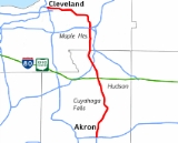
State Route 8 is a road in the U.S.
state of Ohio
. SR 8 stretches from the eastern junction of I-76 and I-77 in Akron
to Public Square
in Cleveland. The route's first few miles are as a limited-access freeway from I-76 and I-77, heading north. The freeway section of the highway has 16 interchanges, and is cosigned with SR 59 for a short distance from Perkins Avenue in Akron to Front Street in Cuyahoga Falls
. The freeway portion ends at I-271
in Macedonia
.
. Just before leaving the center of Akron, an interchange with Perkins Street begins a concurrency with SR 59. The road continues over a viaduct, crossing over several railroads and the Little Cuyahoga River before continuing to the north side of Akron. Between exits 3C and 4, SR 8/59 cross into Cuyahoga Falls
. Those two exits connect with the same stretch of road, but they have different names and are on different sides of the city limit.
The freeway continues north through Cuyahoga Falls, parallel to the Cuyahoga River
proper; the freeway crosses the river just before exit 6. SR 59 leaves the freeway at exit 6 to head east toward Kent
. SR 8, which until now has been heading slightly northeast, turns to the north and northwest after exit 6, interchanging with Graham Road in the process. The road continues through a relatively rural area on the eastern edge of Cuyahoga Valley National Park
. Exits 10, 12, and 14A-B are normally only used as a connection to Hudson
or Blossom Music Center
and other points in the national park, as their immediate areas are sparsely populated and underdeveloped. Once it passes the Ohio Turnpike
, SR 8 continues through a wooded area. Its last exit is with I-271
, after which it suddenly enters Cleveland's southeastern suburbs.
Now known as Northfield Road, SR 8 continues parallel to I-271, intersecting SR 82, SR 14, and SR 17. Following its intersection with SR 17, SR 8 enters a brief concurrency with SR 43, during which it intersects I-480. SR 43 splits off, and SR 8 continues northward before joining US 422 and turning to the west. The new road is briefly known as Chagrin Boulevard before becoming Kinsman Road. SR 8/US 422 continues to the northwest through the immediate Cleveland area; during its approach to downtown Cleveland, SR 87 joins the concurrency, followed by an interchange with I-77.
For its final mile, SR 8/SR 87/US 422 picks up a concurrency of SR 14/SR 43, after which the road becomes known as Ontario Street and turns toward Public Square
, the northern terminus of SR 8. SR 8's northern terminus is shared with seven other roads: SR 3, SR 14, SR 43, SR 87, US 42, US 322 and US 422.
all the way to Cleveland
. Over time, though, parts of the route were renumbered or reassigned, especially in the part south of Akron. In 1926 the portion from Marietta
to Newcomerstown
became U.S. Route 21
. The same year the section from Newcomerstown
to Uhrichsville
became State Route 16 and SR 8 was rerouted from the Ohio River
town of Fly to Uhrichsville
. In 1969, the section from Fly to Canton
was renumbered to State Route 800, the portion from Canton
to Akron
was deleted, and the southern end of the highway was truncated at Akron
, at U.S. Route 224
.
By 1962, the Route 8B freeway was built in Akron
. It became mainline SR 8 in 1969 north of Market Street, and in its entirety by 1971. A section of freeway between Front Street (SR 59) and Graham Road in Cuyahoga Falls and Stow
opened by 1972, with the connecting section opening in 1974. The freeway carried only the SR 59 designation between Tallmadge Avenue in Akron and Front Street in Cuyahoga Falls and had no posted number north of there until 1983, when the SR 8 designation was transferred to the freeway. The final section of freeway opened on May 20, 1988, reaching State Route 303.
SR 8 from Interstate 77
to Perkins Street was rebuilt from 2003 to 2005. The freeway in that stretch previously had onramps and offramps built closely together, creating the danger of weaving traffic. Several ramps were removed and service roads were built on both sides of the freeway.
Route 8 from SR 303 north to Interstate 271
was converted to a full freeway without at-grade intersections between 2008 and 2010. The ramp between State Route 8 northbound and I-271 northbound opened July 24, 2009, and the opposite ramp opened on September 4. The new Turnpike interchange opened in December 2010, well ahead of the projected date of fall 2011.
A new interchange was recently opened at Seasons Road to serve the area near the borders of Cuyahoga Falls
, Stow
, and Hudson
. Although the interchange was completed on January 25, 2010, it was not initially scheduled to open until one month later, on February 26, when an official ribbon-cutting could take place. Two weeks before the scheduled opening, an editorial in the Akron Beacon Journal
lambasted the ribbon-cutting, calling the ceremony a mere "photo op", and questioning why a finished project should sit unused for 31 days. On February 21, the government of Stow, which had been responsible for holding the ceremony, announced the interchange would open in the morning of the next day without a ribbon-cutting.
{| class=wikitable
!County
!Location
!Mile
!#
!Destinations
!Notes
|-
|colspan=6|Begin limited-access segment; southern terminus of 
|-
|rowspan=17|Summit
|rowspan=6|Akron
|0.00
|
|
|Southern terminus.
|-
|1.16
|1A
|
|
|- style="background: #ddffdd"
|1.75
|1B
|
|Southern terminus of concurrency with SR 59.
|- style="background: #ffdddd"
|2.73
|3A
|E. Glenwood Ave.
|This exit is not accessible from southbound SR 8, nor can traffic enter to northbound SR 8.
|-
|3.05
|3B
|
|Signed as exit 3 for southbound traffic, since exits 3A and 3C are not accessible.
|- style="background: #ffdddd"
|3.96
|3C
|Cuyahoga Falls Ave.
|This exit is not accessible from southbound SR 8, nor can traffic enter to northbound SR 8. The actual exit is to Gorge Blvd., although signs guide travelers from the exit to Cuyahoga Falls Ave.
|-
|rowspan=4|Cuyahoga Falls
|4.41
|4
|Howe Ave.
|For southbound traffic, this exit is signed for both Howe Ave. and Cuyahoga Falls Ave., since exit 3C is not accessible.
|-
|5.47
|5A
|Broad Blvd.
|Signed as exit 5 for southbound traffic, since exit 5B is not accessible.
|-style="background: #ffdddd"
|5.66
|5B
|N. Portage Trail
|This exit is not accessible from southbound SR 8, nor can traffic enter to northbound SR 8.
|- style="background: #ddffdd"
|6.11
|6
|
|Southbound traffic exits to Second St. Northern terminus of concurrency with SR 59.
|-
|rowspan=3|Stow
|7.68
|7
|Graham Road – Stow, Silver Lake
|
|-
|9.11
|9
|Steels Corners Rd.
|
|-
|
|10
|Seasons Rd.
|Opened February 22, 2010.
|-
|rowspan=3|Boston Hts.
|12.72
|12
|
|
|-
|
|14A
|Boston Mills Rd. / Hines Hill Rd.
|rowspan = 2| Interchange reconstructed and reopened December, 2010.
|-
|
|14B
|
|-
|rowspan=1|Macedonia
|17.98
|17
|, Erie PA
|
|-
|colspan=6|End limited-access segment
|-
United States
The United States of America is a federal constitutional republic comprising fifty states and a federal district...
state of Ohio
Ohio
Ohio is a Midwestern state in the United States. The 34th largest state by area in the U.S.,it is the 7th‑most populous with over 11.5 million residents, containing several major American cities and seven metropolitan areas with populations of 500,000 or more.The state's capital is Columbus...
. SR 8 stretches from the eastern junction of I-76 and I-77 in Akron
Akron, Ohio
Akron , is the fifth largest city in the U.S. state of Ohio and the county seat of Summit County. It is located in the Great Lakes region approximately south of Lake Erie along the Little Cuyahoga River. As of the 2010 census, the city had a population of 199,110. The Akron Metropolitan...
to Public Square
Public Square
Public Square is the central plaza in downtown Cleveland, Ohio, United States. It takes up four city blocks; Superior Avenue and Ontario Street cross through it. Cleveland's three tallest buildings, Key Tower, 200 Public Square and the Terminal Tower, face the square...
in Cleveland. The route's first few miles are as a limited-access freeway from I-76 and I-77, heading north. The freeway section of the highway has 16 interchanges, and is cosigned with SR 59 for a short distance from Perkins Avenue in Akron to Front Street in Cuyahoga Falls
Cuyahoga Falls, Ohio
As of the census of 2000, there were 49,374 people, 21,655 households, and 13,317 families residing in the city. The population density was 1,932.9 people per square mile . There were 22,727 housing units at an average density of 889.7 per square mile...
. The freeway portion ends at I-271
Interstate 271
Interstate 271 is an auxiliary interstate highway in the suburbs of Cleveland and Akron in the U.S. state of Ohio. The highway is officially designated the "Cleveland Outerbelt East", but rarely referred to by that name.-Route description:...
in Macedonia
Macedonia, Ohio
Macedonia is a city in Summit County, Ohio, United States. The population was 11,188 at the 2010 census. Macedonia is part of the Akron Metropolitan Statistical Area.-History:...
.
Route description
SR 8 begins at an interchange with I-76 and I-77 just southeast of Akron's central business district. The Akron Expressway, as the freeway is known within the city limits, heads up the east side of Akron. SR 8's first interchange is the main access to the central business district and the University of AkronUniversity of Akron
The University of Akron is a coeducational public research university located in Akron, Ohio, United States. The university is part of the University System of Ohio. It was founded in 1870 as a small college affiliated with the Universalist Church. In 1913 ownership was transferred to the City of...
. Just before leaving the center of Akron, an interchange with Perkins Street begins a concurrency with SR 59. The road continues over a viaduct, crossing over several railroads and the Little Cuyahoga River before continuing to the north side of Akron. Between exits 3C and 4, SR 8/59 cross into Cuyahoga Falls
Cuyahoga Falls, Ohio
As of the census of 2000, there were 49,374 people, 21,655 households, and 13,317 families residing in the city. The population density was 1,932.9 people per square mile . There were 22,727 housing units at an average density of 889.7 per square mile...
. Those two exits connect with the same stretch of road, but they have different names and are on different sides of the city limit.
The freeway continues north through Cuyahoga Falls, parallel to the Cuyahoga River
Cuyahoga River
The Cuyahoga River is located in Northeast Ohio in the United States. Outside of Ohio, the river is most famous for being "the river that caught fire", helping to spur the environmental movement in the late 1960s...
proper; the freeway crosses the river just before exit 6. SR 59 leaves the freeway at exit 6 to head east toward Kent
Kent, Ohio
Kent is a city in the U.S. state of Ohio and the largest city in Portage County. It is located along the Cuyahoga River in Northeastern Ohio on the western edge of the county. The population was 27,906 at the 2000 United States Census and 28,904 in the 2010 Census...
. SR 8, which until now has been heading slightly northeast, turns to the north and northwest after exit 6, interchanging with Graham Road in the process. The road continues through a relatively rural area on the eastern edge of Cuyahoga Valley National Park
Cuyahoga Valley National Park
Cuyahoga Valley National Park preserves and reclaims the rural landscape along the Cuyahoga River between Akron and Cleveland in Northeast Ohio. The park is the only national park in Ohio.Cuyahoga means "crooked river" in Mohawk....
. Exits 10, 12, and 14A-B are normally only used as a connection to Hudson
Hudson, Ohio
Hudson is a city in Summit County, Ohio, United States. The population was 22,262 at the 2010 census. It is an affluent exurban community and is part of the Akron, Ohio Metropolitan Statistical Area...
or Blossom Music Center
Blossom Music Center
Blossom Music Center is an amphitheatre located in Cuyahoga Falls, Ohio. The pavilion seats 5,700 people, with space for about 13,500 more on the lawn. It is the summer home of the Cleveland Orchestra, which performs its annual Blossom Festival there. The venue is also host to a full summer...
and other points in the national park, as their immediate areas are sparsely populated and underdeveloped. Once it passes the Ohio Turnpike
Ohio Turnpike
The Ohio Turnpike, officially the James W. Shocknessy Ohio Turnpike, is a -long, limited-access toll highway in the U.S. state of Ohio, serving as a primary corridor to Chicago and Pittsburgh...
, SR 8 continues through a wooded area. Its last exit is with I-271
Interstate 271
Interstate 271 is an auxiliary interstate highway in the suburbs of Cleveland and Akron in the U.S. state of Ohio. The highway is officially designated the "Cleveland Outerbelt East", but rarely referred to by that name.-Route description:...
, after which it suddenly enters Cleveland's southeastern suburbs.
Now known as Northfield Road, SR 8 continues parallel to I-271, intersecting SR 82, SR 14, and SR 17. Following its intersection with SR 17, SR 8 enters a brief concurrency with SR 43, during which it intersects I-480. SR 43 splits off, and SR 8 continues northward before joining US 422 and turning to the west. The new road is briefly known as Chagrin Boulevard before becoming Kinsman Road. SR 8/US 422 continues to the northwest through the immediate Cleveland area; during its approach to downtown Cleveland, SR 87 joins the concurrency, followed by an interchange with I-77.
For its final mile, SR 8/SR 87/US 422 picks up a concurrency of SR 14/SR 43, after which the road becomes known as Ontario Street and turns toward Public Square
Public Square
Public Square is the central plaza in downtown Cleveland, Ohio, United States. It takes up four city blocks; Superior Avenue and Ontario Street cross through it. Cleveland's three tallest buildings, Key Tower, 200 Public Square and the Terminal Tower, face the square...
, the northern terminus of SR 8. SR 8's northern terminus is shared with seven other roads: SR 3, SR 14, SR 43, SR 87, US 42, US 322 and US 422.
History
SR 8 was one of the original state highways in Ohio. It went from MariettaMarietta, Ohio
Marietta is a city in and the county seat of Washington County, Ohio, United States. During 1788, pioneers to the Ohio Country established Marietta as the first permanent American settlement of the new United States in the Northwest Territory. Marietta is located in southeastern Ohio at the mouth...
all the way to Cleveland
Cleveland, Ohio
Cleveland is a city in the U.S. state of Ohio and is the county seat of Cuyahoga County, the most populous county in the state. The city is located in northeastern Ohio on the southern shore of Lake Erie, approximately west of the Pennsylvania border...
. Over time, though, parts of the route were renumbered or reassigned, especially in the part south of Akron. In 1926 the portion from Marietta
Marietta, Ohio
Marietta is a city in and the county seat of Washington County, Ohio, United States. During 1788, pioneers to the Ohio Country established Marietta as the first permanent American settlement of the new United States in the Northwest Territory. Marietta is located in southeastern Ohio at the mouth...
to Newcomerstown
Newcomerstown, Ohio
Newcomerstown is a village in Tuscarawas County, Ohio, United States, east-northeast of Columbus. In the late 1770s, this was the largest Lenape village on the Tuscarawas River, with 700 residents. Chief Newcomer was the leader of the western Lenape here, and they called the village...
became U.S. Route 21
U.S. Route 21
U.S. Route 21 is a north–south United States highway of , from Hunting Island State Park, South Carolina to Wytheville, Virginia.-South Carolina:...
. The same year the section from Newcomerstown
Newcomerstown, Ohio
Newcomerstown is a village in Tuscarawas County, Ohio, United States, east-northeast of Columbus. In the late 1770s, this was the largest Lenape village on the Tuscarawas River, with 700 residents. Chief Newcomer was the leader of the western Lenape here, and they called the village...
to Uhrichsville
Uhrichsville, Ohio
Uhrichsville is a city in Tuscarawas County, Ohio, United States. The population was 5,662 at the 2000 census. Claymont City School District is the major education provider for the city of Uhrichsville and for the village of Dennison, Ohio...
became State Route 16 and SR 8 was rerouted from the Ohio River
Ohio River
The Ohio River is the largest tributary, by volume, of the Mississippi River. At the confluence, the Ohio is even bigger than the Mississippi and, thus, is hydrologically the main stream of the whole river system, including the Allegheny River further upstream...
town of Fly to Uhrichsville
Uhrichsville, Ohio
Uhrichsville is a city in Tuscarawas County, Ohio, United States. The population was 5,662 at the 2000 census. Claymont City School District is the major education provider for the city of Uhrichsville and for the village of Dennison, Ohio...
. In 1969, the section from Fly to Canton
Canton, Ohio
Canton is the county seat of Stark County in northeastern Ohio, approximately south of Akron and south of Cleveland.The City of Caton is the largest incorporated area within the Canton-Massillon Metropolitan Statistical Area...
was renumbered to State Route 800, the portion from Canton
Canton, Ohio
Canton is the county seat of Stark County in northeastern Ohio, approximately south of Akron and south of Cleveland.The City of Caton is the largest incorporated area within the Canton-Massillon Metropolitan Statistical Area...
to Akron
Akron, Ohio
Akron , is the fifth largest city in the U.S. state of Ohio and the county seat of Summit County. It is located in the Great Lakes region approximately south of Lake Erie along the Little Cuyahoga River. As of the 2010 census, the city had a population of 199,110. The Akron Metropolitan...
was deleted, and the southern end of the highway was truncated at Akron
Akron, Ohio
Akron , is the fifth largest city in the U.S. state of Ohio and the county seat of Summit County. It is located in the Great Lakes region approximately south of Lake Erie along the Little Cuyahoga River. As of the 2010 census, the city had a population of 199,110. The Akron Metropolitan...
, at U.S. Route 224
U.S. Route 224
U.S. Route 224 is a spur of U.S. Route 24. It currently runs for 289 miles from New Castle, Pennsylvania at Pennsylvania Route 18 to Huntington, Indiana at U.S. Route 24. It passes through the states of Pennsylvania, Ohio and Indiana...
.
By 1962, the Route 8B freeway was built in Akron
Akron, Ohio
Akron , is the fifth largest city in the U.S. state of Ohio and the county seat of Summit County. It is located in the Great Lakes region approximately south of Lake Erie along the Little Cuyahoga River. As of the 2010 census, the city had a population of 199,110. The Akron Metropolitan...
. It became mainline SR 8 in 1969 north of Market Street, and in its entirety by 1971. A section of freeway between Front Street (SR 59) and Graham Road in Cuyahoga Falls and Stow
Stow, Ohio
Stow is a city in Summit County, Ohio, United States. The population was 32,139 at the 2000 census and 33,899 as of 2008. It is a suburban community that is part of the Akron metropolitan area. Stow is located adjacent to several other suburban communities in Summit and Portage Counties...
opened by 1972, with the connecting section opening in 1974. The freeway carried only the SR 59 designation between Tallmadge Avenue in Akron and Front Street in Cuyahoga Falls and had no posted number north of there until 1983, when the SR 8 designation was transferred to the freeway. The final section of freeway opened on May 20, 1988, reaching State Route 303.
SR 8 from Interstate 77
Interstate 77
Interstate 77 is an Interstate Highway in the eastern United States. It traverses diverse terrain, from the mountainous state of West Virginia to the rolling farmlands of North Carolina and Ohio. It largely supplants the old U.S...
to Perkins Street was rebuilt from 2003 to 2005. The freeway in that stretch previously had onramps and offramps built closely together, creating the danger of weaving traffic. Several ramps were removed and service roads were built on both sides of the freeway.
Route 8 from SR 303 north to Interstate 271
Interstate 271
Interstate 271 is an auxiliary interstate highway in the suburbs of Cleveland and Akron in the U.S. state of Ohio. The highway is officially designated the "Cleveland Outerbelt East", but rarely referred to by that name.-Route description:...
was converted to a full freeway without at-grade intersections between 2008 and 2010. The ramp between State Route 8 northbound and I-271 northbound opened July 24, 2009, and the opposite ramp opened on September 4. The new Turnpike interchange opened in December 2010, well ahead of the projected date of fall 2011.
A new interchange was recently opened at Seasons Road to serve the area near the borders of Cuyahoga Falls
Cuyahoga Falls, Ohio
As of the census of 2000, there were 49,374 people, 21,655 households, and 13,317 families residing in the city. The population density was 1,932.9 people per square mile . There were 22,727 housing units at an average density of 889.7 per square mile...
, Stow
Stow, Ohio
Stow is a city in Summit County, Ohio, United States. The population was 32,139 at the 2000 census and 33,899 as of 2008. It is a suburban community that is part of the Akron metropolitan area. Stow is located adjacent to several other suburban communities in Summit and Portage Counties...
, and Hudson
Hudson, Ohio
Hudson is a city in Summit County, Ohio, United States. The population was 22,262 at the 2010 census. It is an affluent exurban community and is part of the Akron, Ohio Metropolitan Statistical Area...
. Although the interchange was completed on January 25, 2010, it was not initially scheduled to open until one month later, on February 26, when an official ribbon-cutting could take place. Two weeks before the scheduled opening, an editorial in the Akron Beacon Journal
Akron Beacon Journal
The Akron Beacon Journal is a four-time Pulitzer Prize-winning morning newspaper in Akron, Ohio, United States, and published by Black Press Ltd.. It is the sole daily newspaper in Akron and is distributed throughout Northeast Ohio. The paper places a strong emphasis on local news and business...
lambasted the ribbon-cutting, calling the ceremony a mere "photo op", and questioning why a finished project should sit unused for 31 days. On February 21, the government of Stow, which had been responsible for holding the ceremony, announced the interchange would open in the morning of the next day without a ribbon-cutting.
Limited-access segment
The list goes from south to north; entries in the # and Destinations columns reflect signage as seen by northbound traffic. Differences with southbound signage are noted in the Notes column.{| class=wikitable
!County
!Location
!Mile
!#
Exit number
An exit number is a number assigned to a road junction, usually an exit from a freeway. It is usually marked on the same sign as the destinations of the exit, as well as a sign in the gore....
!Destinations
!Notes
|-
|colspan=6|
|-
|rowspan=17|Summit
Summit County, Ohio
Summit County is an urban county located in the state of Ohio, United States. As of the 2000 census, the population was 542,899. In the 2010 Census the population was 541,781. Its county seat is Akron...
|rowspan=6|Akron
Akron, Ohio
Akron , is the fifth largest city in the U.S. state of Ohio and the county seat of Summit County. It is located in the Great Lakes region approximately south of Lake Erie along the Little Cuyahoga River. As of the 2010 census, the city had a population of 199,110. The Akron Metropolitan...
|0.00
|
|
|Southern terminus.
|-
|1.16
|1A
|
|
|- style="background: #ddffdd"
|1.75
|1B
|
|Southern terminus of concurrency with SR 59.
|- style="background: #ffdddd"
|2.73
|3A
|E. Glenwood Ave.
|This exit is not accessible from southbound SR 8, nor can traffic enter to northbound SR 8.
|-
|3.05
|3B
|
|Signed as exit 3 for southbound traffic, since exits 3A and 3C are not accessible.
|- style="background: #ffdddd"
|3.96
|3C
|Cuyahoga Falls Ave.
|This exit is not accessible from southbound SR 8, nor can traffic enter to northbound SR 8. The actual exit is to Gorge Blvd., although signs guide travelers from the exit to Cuyahoga Falls Ave.
|-
|rowspan=4|Cuyahoga Falls
Cuyahoga Falls, Ohio
As of the census of 2000, there were 49,374 people, 21,655 households, and 13,317 families residing in the city. The population density was 1,932.9 people per square mile . There were 22,727 housing units at an average density of 889.7 per square mile...
|4.41
|4
|Howe Ave.
|For southbound traffic, this exit is signed for both Howe Ave. and Cuyahoga Falls Ave., since exit 3C is not accessible.
|-
|5.47
|5A
|Broad Blvd.
|Signed as exit 5 for southbound traffic, since exit 5B is not accessible.
|-style="background: #ffdddd"
|5.66
|5B
|N. Portage Trail
|This exit is not accessible from southbound SR 8, nor can traffic enter to northbound SR 8.
|- style="background: #ddffdd"
|6.11
|6
|
|Southbound traffic exits to Second St. Northern terminus of concurrency with SR 59.
|-
|rowspan=3|Stow
Stow, Ohio
Stow is a city in Summit County, Ohio, United States. The population was 32,139 at the 2000 census and 33,899 as of 2008. It is a suburban community that is part of the Akron metropolitan area. Stow is located adjacent to several other suburban communities in Summit and Portage Counties...
|7.68
|7
|Graham Road – Stow, Silver Lake
Silver Lake, Ohio
Silver Lake is a village in Summit County, Ohio, United States of America. It is an affluent suburb of Akron and is part of the Akron Metropolitan Statistical Area. The population was 3,019 at the 2000 census...
|
|-
|9.11
|9
|Steels Corners Rd.
|
|-
|
|10
|Seasons Rd.
|Opened February 22, 2010.
|-
|rowspan=3|Boston Hts.
Boston Heights, Ohio
Boston Heights is a village in Summit County, Ohio, United States. The population was 1,186 at the 2000 census. It is part of the Akron Metropolitan Statistical Area.-Geography:Boston Heights is located at ....
|12.72
|12
|
|
|-
|
|14A
|Boston Mills Rd. / Hines Hill Rd.
|rowspan = 2| Interchange reconstructed and reopened December, 2010.
|-
|
|14B
|
|-
|rowspan=1|Macedonia
Macedonia, Ohio
Macedonia is a city in Summit County, Ohio, United States. The population was 11,188 at the 2010 census. Macedonia is part of the Akron Metropolitan Statistical Area.-History:...
|17.98
|17
|, Erie PA
Erie, Pennsylvania
Erie is a city located in northwestern Pennsylvania in the United States. Named for the lake and the Native American tribe that resided along its southern shore, Erie is the state's fourth-largest city , with a population of 102,000...
|
|-
|colspan=6|
|-