

Cuyahoga River
Encyclopedia
United States
The United States of America is a federal constitutional republic comprising fifty states and a federal district...
. Outside of Ohio
Ohio
Ohio is a Midwestern state in the United States. The 34th largest state by area in the U.S.,it is the 7th‑most populous with over 11.5 million residents, containing several major American cities and seven metropolitan areas with populations of 500,000 or more.The state's capital is Columbus...
, the river is most famous for being "the river that caught fire", helping to spur the environmental movement
Environmental movement
The environmental movement, a term that includes the conservation and green politics, is a diverse scientific, social, and political movement for addressing environmental issues....
in the late 1960s. Native Americans
Native Americans in the United States
Native Americans in the United States are the indigenous peoples in North America within the boundaries of the present-day continental United States, parts of Alaska, and the island state of Hawaii. They are composed of numerous, distinct tribes, states, and ethnic groups, many of which survive as...
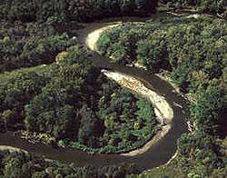
called this winding water "Cuyahoga," which means "crooked river" in the Iroquois language.
Course
The Cuyahoga watershed begins its 100 miles (160.9 km) journey in Hambden, OhioHambden Township, Geauga County, Ohio
Hambden Township is one of the sixteen townships of Geauga County, Ohio, United States. The 2000 census found 4,024 people in the township.-Geography:Located in the northern part of the county, it borders the following townships:...
, flowing southward to the confluence of the East Branch Cuyahoga River and West Branch Cuyahoga River in Burton
Burton Township, Geauga County, Ohio
Burton Township is one of the sixteen townships of Geauga County, Ohio, United States. The 2000 census found 4,358 people in the township, 2,908 of whom lived in the unincorporated portions of the township.-Geography:...
where the Cuyahoga River officially begins. It continues on its 84.9 miles (136.6 km) journey flowing Southward to Cuyahoga Falls
Cuyahoga Falls, Ohio
As of the census of 2000, there were 49,374 people, 21,655 households, and 13,317 families residing in the city. The population density was 1,932.9 people per square mile . There were 22,727 housing units at an average density of 889.7 per square mile...
, where it turns sharply North and flows through the Cuyahoga Valley National Park
Cuyahoga Valley National Park
Cuyahoga Valley National Park preserves and reclaims the rural landscape along the Cuyahoga River between Akron and Cleveland in Northeast Ohio. The park is the only national park in Ohio.Cuyahoga means "crooked river" in Mohawk....
(CUVA or CVNP) in Northern Summit County
Summit County, Ohio
Summit County is an urban county located in the state of Ohio, United States. As of the 2000 census, the population was 542,899. In the 2010 Census the population was 541,781. Its county seat is Akron...
and Southern Cuyahoga County
Cuyahoga County, Ohio
Cuyahoga County is a county located in the state of Ohio, United States. It is the most populous county in Ohio; as of the 2010 census, the population was 1,280,122. Its county seat is Cleveland. Cuyahoga County is part of Greater Cleveland, a metropolitan area, and Northeast Ohio, a...
. It then flows through Independence
Independence, Ohio
Independence is a city in Cuyahoga County, Ohio, in the United States. As of the 2010 census, the city population was 7,133.-Geography:Independence is located at .According to the United States Census Bureau, the city has a total area of , all of it land....
, Valley View
Valley View, Ohio
Valley View is a village in Cuyahoga County, Ohio, United States. The population was 2,034 at the 2010 census. It is a suburb of Cleveland with a town council form of government. It is part of a school district that also includes nearby Cuyahoga Heights and Brooklyn Heights...
, Cuyahoga Heights
Cuyahoga Heights, Ohio
Cuyahoga Heights is a village in Cuyahoga County, Ohio, United States. The population was 638 at the 2010 census.-Geography:Cuyahoga Heights is located at ....
, Newburgh Heights
Newburgh Heights, Ohio
Newburgh Heights is a village in Cuyahoga County, Ohio, United States. The population was 2,167 at the 2010 census.-Geography:Newburgh Heights is located at ....
and Cleveland
Cleveland, Ohio
Cleveland is a city in the U.S. state of Ohio and is the county seat of Cuyahoga County, the most populous county in the state. The city is located in northeastern Ohio on the southern shore of Lake Erie, approximately west of the Pennsylvania border...
to its northern terminus, emptying into Lake Erie
Lake Erie
Lake Erie is the fourth largest lake of the five Great Lakes in North America, and the tenth largest globally. It is the southernmost, shallowest, and smallest by volume of the Great Lakes and therefore also has the shortest average water residence time. It is bounded on the north by the...
. The Cuyahoga River and its tributaries drain 813 square miles (2,105.7 km²) of land in portions of six counties.
The river is a relatively recent geological formation, formed by the advance and retreat of ice sheets during the last ice age
Ice age
An ice age or, more precisely, glacial age, is a generic geological period of long-term reduction in the temperature of the Earth's surface and atmosphere, resulting in the presence or expansion of continental ice sheets, polar ice sheets and alpine glaciers...
. The final glacial
Glacier
A glacier is a large persistent body of ice that forms where the accumulation of snow exceeds its ablation over many years, often centuries. At least 0.1 km² in area and 50 m thick, but often much larger, a glacier slowly deforms and flows due to stresses induced by its weight...
retreat, which occurred 10,000–12,000 years ago, caused changes in the drainage pattern near Akron
Akron, Ohio
Akron , is the fifth largest city in the U.S. state of Ohio and the county seat of Summit County. It is located in the Great Lakes region approximately south of Lake Erie along the Little Cuyahoga River. As of the 2010 census, the city had a population of 199,110. The Akron Metropolitan...
. This change in pattern caused the originally southward-flowing Cuyahoga to flow to the north. As its newly reversed currents flowed toward Lake Erie, the river carved its way around glacial debris left by the receding ice sheet, resulting in the river's winding U-shape. These meanderings stretched the length of the river (which was only 30 miles (50 km) when travelled directly) into a 100-mile (160 km) trek from its headwaters to its mouth. The depth of the river (except where noted below) ranges from 3 to 6 feet (90–180 cm).
History
Moses CleavelandMoses Cleaveland
Moses Cleaveland was a lawyer, politician, soldier, and surveyor from Connecticut who founded the U.S. city of Cleveland, Ohio, while surveying the Western Reserve in 1796.-Early life:...
, a surveyor
Surveying
See Also: Public Land Survey SystemSurveying or land surveying is the technique, profession, and science of accurately determining the terrestrial or three-dimensional position of points and the distances and angles between them...
charged with exploring the Connecticut Western Reserve
Connecticut Western Reserve
The Connecticut Western Reserve was land claimed by Connecticut from 1662 to 1800 in the Northwest Territory in what is now northeastern Ohio.-History:...
, first arrived at the mouth of the Cuyahoga River in 1796, and subsequently decided to locate a settlement there, which became Cleveland, Ohio
Cleveland, Ohio
Cleveland is a city in the U.S. state of Ohio and is the county seat of Cuyahoga County, the most populous county in the state. The city is located in northeastern Ohio on the southern shore of Lake Erie, approximately west of the Pennsylvania border...
.
The river was one of the features along which the "Greenville Treaty Line" ran beginning in 1795, per the Treaty of Greenville
Treaty of Greenville
The Treaty of Greenville was signed at Fort Greenville , on August 3, 1795, between a coalition of Native Americans & Frontiers men, known as the Western Confederacy, and the United States following the Native American loss at the Battle of Fallen Timbers. It put an end to the Northwest Indian War...
, effectively becoming the western boundary of the United States and remaining as such briefly.
Environmental concerns
The Cuyahoga River at one time was one of the most pollutedWater pollution
Water pollution is the contamination of water bodies . Water pollution occurs when pollutants are discharged directly or indirectly into water bodies without adequate treatment to remove harmful compounds....
rivers in the United States. The reach
Reach (geography)
A reach in geography can mean several things. Most generally, a reach is any length of a stream between any two points. The points may be selected for any reason, such as gauging stations, river miles, natural features, and topography. They may be arbitrary or vague.A reach may also be an expanse,...
from Akron to Cleveland was devoid of fish
Fish
Fish are a paraphyletic group of organisms that consist of all gill-bearing aquatic vertebrate animals that lack limbs with digits. Included in this definition are the living hagfish, lampreys, and cartilaginous and bony fish, as well as various extinct related groups...
. A Kent State University
Kent State University
Kent State University is a public research university located in Kent, Ohio, United States. The university has eight campuses around the northeast Ohio region with the main campus in Kent being the largest...
symposium, convened one year before the infamous 1969 fire, described one section of the river:
- From 1,000 feet below Lower Harvard Bridge to Newburgh and South Shore Railroad Bridge, the channel becomes wider and deeper and the level is controlled by Lake Erie. Downstream of the railroad bridge to the harbor, the depth is held constant by dredging, and the width is maintained by piling along both banks. The surface is covered with the brown oily film observed upstream as far as the Southerly Plant effluent. In addition, large quantities of black heavy oil floating in slicks, sometimes several inches thick, are observed frequently. Debris and trash are commonly caught up in these slicks forming an unsightly floating mess. Anaerobic action is common as the dissolved oxygen is seldom above a fraction of a part per million. The discharge of cooling water increases the temperature by 10 to 15°F. The velocity is negligible, and sludge accumulates on the bottom. Animal life does not exist. Only the algae OscillatoriaOscillatoriaOscillatoria is a genus of filamentous cyanobacterium which is named for the oscillation in its movement. Filaments in the colonies can slide back and forth against each other until the whole mass is reoriented to its light source. It is commonly found in watering-troughs waters, and is mainly...
grows along the piers above the water line. - The color changes from gray-brown to rusty brown as the river proceeds downstream. Transparency is less than 0.5 feet in this reach. This entire reach is grossly polluted.
There have reportedly been at least thirteen fires on the Cuyahoga River, the first occurring in 1868. The largest river fire in 1952 caused over $1 million in damage to boats and a riverfront office building. Fires erupted on the river several more times before June 22, 1969, when a river fire captured the attention of Time
Time (magazine)
Time is an American news magazine. A European edition is published from London. Time Europe covers the Middle East, Africa and, since 2003, Latin America. An Asian edition is based in Hong Kong...
magazine, which described the Cuyahoga as the river that "oozes rather than flows" and in which a person "does not drown but decays."
Clean Water Act
The Clean Water Act is the primary federal law in the United States governing water pollution. Commonly abbreviated as the CWA, the act established the goals of eliminating releases of high amounts of toxic substances into water, eliminating additional water pollution by 1985, and ensuring that...
, Great Lakes Water Quality Agreement, and the creation of the federal Environmental Protection Agency
United States Environmental Protection Agency
The U.S. Environmental Protection Agency is an agency of the federal government of the United States charged with protecting human health and the environment, by writing and enforcing regulations based on laws passed by Congress...
and the Ohio Environmental Protection Agency
Ohio Environmental Protection Agency
The Ohio Environmental Protection Agency is a government agency in the state of Ohio charged with maintaining environmental quality. It was created on October 23, 1972 when previously separate environmental programs where combined into a single department.-Mission statement:"To protect the...
(OEPA). As a result, large point sources of pollution on the Cuyahoga have received significant attention from the OEPA in recent decades. These events are referred to in Randy Newman's
Randy Newman
Randall Stuart "Randy" Newman is an American singer-songwriter, arranger, composer, and pianist who is known for his mordant pop songs and for film scores....
1972 song "Burn On
Sail Away (Randy Newman album)
-Personnel:* Randy Newman - arranger, composer, piano, vocals* Ry Cooder - guitars on "Last Night I Had a Dream" & "You Can Leave Your Hat On"* Russ Titelman - guitars* Jim Keltner - drums* Gene Parsons - drums* Earl Palmer - drums* Chris Ethridge - bass...
", R.E.M.
R.E.M.
R.E.M. was an American rock band formed in Athens, Georgia, in 1980 by singer Michael Stipe, guitarist Peter Buck, bassist Mike Mills and drummer Bill Berry. One of the first popular alternative rock bands, R.E.M. gained early attention due to Buck's ringing, arpeggiated guitar style and Stipe's...
's 1986 song "Cuyahoga", and Adam Again
Adam Again
Adam Again was a rock band founded and led by vocalist Gene Eugene, with Riki Michele on vocals, Paul Valadez on bass, Jon Knox on drums, Greg Lawless on guitar...
's 1992 song "River on Fire". Great Lakes Brewing Company
Great Lakes Brewing Company
Great Lakes Brewing Company is a Cleveland, Ohio-based regional brewery and brewpub, which has been in operation since 1988. The brewery has been cited as important to Cleveland's local identity. As of 2010, it is the 22nd largest craft brewery and 31st largest overall brewery in the United States...
of Cleveland, Ohio have named their Burning River Pale Ale after the event. During the Gulf Oil Spill of May 2010, New York Times economist and Nobel Laureate Paul Krugman referred to the Cuyahoga fire as the start of “environmentalism”.
Water quality
Water quality
Water quality is the physical, chemical and biological characteristics of water. It is a measure of the condition of water relative to the requirements of one or more biotic species and or to any human need or purpose. It is most frequently used by reference to a set of standards against which...
has improved and, partially in recognition of this improvement, the Cuyahoga River was designated as one of 14 American Heritage Rivers in 1998. Despite these efforts pollution continues to exist in the Cuyahoga River due to other sources of pollution, including urban runoff
Urban runoff
Urban runoff is surface runoff of rainwater created by urbanization. This runoff is a major source of water pollution in many parts of the United States and other urban communities worldwide.-Overview:...
, nonpoint source
Nonpoint source pollution
Nonpoint source pollution refers to both water and air pollution from diffuse sources. Nonpoint source water pollution affects a water body from sources such as polluted runoff from agricultural areas draining into a river, or wind-borne debris blowing out to sea. Nonpoint source air pollution...
problems, combined sewer overflow
Combined sewer overflow
A combined sewer is a type of sewer system that collects sanitary sewage and stormwater runoff in a single pipe system. Combined sewers can cause serious water pollution problems due to combined sewer overflows, which are caused by large variations in flow between dry and wet weather...
s, and stagnation
Water stagnation
Water stagnation occurs when water stops flowing. Stagnant water can be a major environmental hazard.-Dangers:Malaria and dengue are among the main dangers of stagnant water, which can become a breeding ground for the mosquitoes that transmit these diseases.Stagnant or Stailment water can be...
due to water impounded by dam
Dam
A dam is a barrier that impounds water or underground streams. Dams generally serve the primary purpose of retaining water, while other structures such as floodgates or levees are used to manage or prevent water flow into specific land regions. Hydropower and pumped-storage hydroelectricity are...
s. For this reason, the Environmental Protection Agency classified portions of the Cuyahoga River Watershed
Drainage basin
A drainage basin is an extent or an area of land where surface water from rain and melting snow or ice converges to a single point, usually the exit of the basin, where the waters join another waterbody, such as a river, lake, reservoir, estuary, wetland, sea, or ocean...
as one of 43 Great Lakes Areas of Concern
Great Lakes Areas of Concern
Great Lakes Areas of Concern are designated geographic areas within the Great Lakes Basin that show severe environmental degradation. There are a total of 43 areas of concern within the Great Lakes, 26 being in the U.S., 17 in Canada, with five shared by the two countries.The Great Lakes, the...
. The most polluted portions of the river now generally meet established aquatic life water quality standards except near dam
Dam
A dam is a barrier that impounds water or underground streams. Dams generally serve the primary purpose of retaining water, while other structures such as floodgates or levees are used to manage or prevent water flow into specific land regions. Hydropower and pumped-storage hydroelectricity are...
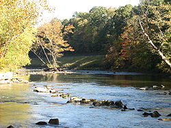
impoundments. The reasons for not meeting standards near the dam pools are habitat and fish passage issues rather than water quality. River reaches that were once devoid of fish now support 44 species. The most recent survey in 2008 revealed the two most common species in the river were Hogsuckers and Spotfin Shiners
Cyprinella
Cyprinella is the genus of satinfin shiners, ray-finned fish in the Cyprinidae family.It contains the following species:*Cyprinella alvarezdelvillari Contreras-Balderas & Lozano-Vilano, 1994...
, both moderately sensitive to water quality. Habitat issues within the 5.6 miles (9 km) navigation channel
Channel (geography)
In physical geography, a channel is the physical confine of a river, slough or ocean strait consisting of a bed and banks.A channel is also the natural or human-made deeper course through a reef, sand bar, bay, or any shallow body of water...
still preclude a robust fishery in that reach. Recreation water quality standards (using bacteria
Bacteria
Bacteria are a large domain of prokaryotic microorganisms. Typically a few micrometres in length, bacteria have a wide range of shapes, ranging from spheres to rods and spirals...
as indicators) are generally met during dry weather conditions, but are often exceeded during significant rains due to non-point sources and combined sewer overflows.
Modifications
Lake Erie
Lake Erie is the fourth largest lake of the five Great Lakes in North America, and the tenth largest globally. It is the southernmost, shallowest, and smallest by volume of the Great Lakes and therefore also has the shortest average water residence time. It is bounded on the north by the...
approximately 4000 feet (1.2 km) west of its current mouth, forming a shallow marsh
Marsh
In geography, a marsh, or morass, is a type of wetland that is subject to frequent or continuous flood. Typically the water is shallow and features grasses, rushes, reeds, typhas, sedges, other herbaceous plants, and moss....
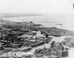
. The current mouth is man-made, and it lies just west of present-day downtown Cleveland
Downtown Cleveland
Downtown Cleveland is the central business district of the City of Cleveland and Northeast Ohio. Reinvestment in the area in the mid-1990s spurred a rebirth that continues to this day, with over $2 billion in residential and commercial developments slated for the area over the next few years...
, which allows shipping traffic to flow freely between the river and the lake. Additionally, the U.S. Army Corps of Engineers periodically dredge
Dredge
Dredging is an excavation activity or operation usually carried out at least partly underwater, in shallow seas or fresh water areas with the purpose of gathering up bottom sediments and disposing of them at a different location...
s the navigation channel of the otherwise shallow river to a depth of 27 feet (8.2 m), along the river's lower 5 miles (8 km), from its mouth up to the Mittal Steel
Mittal Steel Company
Mittal Steel Company N.V. was one of the world's largest steel producers by volume, and also one of the largests in turnover. The company is now part of ArcelorMittal....
Cleveland Works steel mill
Steel mill
A steel mill or steelworks is an industrial plant for the manufacture of steel.Steel is an alloy of iron and carbon. It is produced in a two-stage process. First, iron ore is reduced or smelted with coke and limestone in a blast furnace, producing molten iron which is either cast into pig iron or...
s, to accommodate Great Lakes
Great Lakes
The Great Lakes are a collection of freshwater lakes located in northeastern North America, on the Canada – United States border. Consisting of Lakes Superior, Michigan, Huron, Erie, and Ontario, they form the largest group of freshwater lakes on Earth by total surface, coming in second by volume...
freighter
Lake freighter
Lake freighters, or Lakers, are bulk carrier vessels that ply the Great Lakes. The best known was the , the most recent and largest major vessel to be wrecked on the Lakes. These vessels are traditionally called boats, although classified as ships. In the mid-20th century, 300 lakers worked the...
traffic which serves the bulk (asphalt
Asphalt
Asphalt or , also known as bitumen, is a sticky, black and highly viscous liquid or semi-solid that is present in most crude petroleums and in some natural deposits, it is a substance classed as a pitch...
, gravel
Gravel
Gravel is composed of unconsolidated rock fragments that have a general particle size range and include size classes from granule- to boulder-sized fragments. Gravel can be sub-categorized into granule and cobble...
, petroleum
Petroleum
Petroleum or crude oil is a naturally occurring, flammable liquid consisting of a complex mixture of hydrocarbons of various molecular weights and other liquid organic compounds, that are found in geologic formations beneath the Earth's surface. Petroleum is recovered mostly through oil drilling...
, salt
Salt
In chemistry, salts are ionic compounds that result from the neutralization reaction of an acid and a base. They are composed of cations and anions so that the product is electrically neutral...
, steel, and other) industries located along the lower Cuyahoga River banks in Cleveland's Flats district. The Corps of Engineers has also straightened river banks
River engineering
River engineering is the process of planned human intervention in the course, characteristics or flow of a river with the intention of producing some defined benefit. People have intervened in the natural course and behaviour of rivers since before recorded history - to manage the water resources,...
and widened turning basins in the Federal Navigation Channel on the lower Cuyahoga River to facilitate maritime operations.
Ice-breaking
The United States Coast GuardUnited States Coast Guard
The United States Coast Guard is a branch of the United States Armed Forces and one of the seven U.S. uniformed services. The Coast Guard is a maritime, military, multi-mission service unique among the military branches for having a maritime law enforcement mission and a federal regulatory agency...
sometimes conducts fall and spring ice-breaking operations along Lake Erie
Lake Erie
Lake Erie is the fourth largest lake of the five Great Lakes in North America, and the tenth largest globally. It is the southernmost, shallowest, and smallest by volume of the Great Lakes and therefore also has the shortest average water residence time. It is bounded on the north by the...
and the lower Cuyahoga River to prolong the Great Lakes shipping season, depending on shipping schedules and weather conditions.
Flooding
Some attempts (including dams and dredging) have been made to control floodFlood
A flood is an overflow of an expanse of water that submerges land. The EU Floods directive defines a flood as a temporary covering by water of land not normally covered by water...
ing along the Cuyahoga River basin. As a result of speculative land development
Land development
Land development refers to altering the landscape in any number of ways such as:* changing landforms from a natural or semi-natural state for a purpose such as agriculture or housing...
, buildings have been erected on many flat areas that are only a few feet above normal river levels. Sudden strong rain or snow storms can create severe flooding in these low-lying areas.
The upper Cuyahoga River, starting at 1093 feet (333.1 m) over 84 miles (135.2 km) from its mouth, drops in elevation fairly steeply, creating falls
Waterfall
A waterfall is a place where flowing water rapidly drops in elevation as it flows over a steep region or a cliff.-Formation:Waterfalls are commonly formed when a river is young. At these times the channel is often narrow and deep. When the river courses over resistant bedrock, erosion happens...
and rapid
Rapid
A rapid is a section of a river where the river bed has a relatively steep gradient causing an increase in water velocity and turbulence. A rapid is a hydrological feature between a run and a cascade. A rapid is characterised by the river becoming shallower and having some rocks exposed above the...
s in some places; the lower Cuyahoga River only drops several feet along the last several miles of the lower river to 571 feet (174 m) at the mouth on Lake Erie, resulting in relatively slow moving waters that can take a while to drain compared to the upper Cuyahoga River.
Some tributary elevations above are higher than the Cuyahoga River elevation, because of small waterfalls at or near their confluences; and distances are measured in "river miles" along the river's length from its mouth on Lake Erie.
Ohio and Erie Canal diversion dam
The Brecksville Dam at river mile 20 is the first dam upstream of Lake Erie. It impacts fish populations by restricting fish passage.Gorge Metropolitan Park Dam

Oxygen saturation
Oxygen saturation or dissolved oxygen is a relative measure of the amount of oxygen that is dissolved or carried in a given medium. It can be measured with a dissolved oxygen probe such as an oxygen sensor or an optode in liquid media, usually water.It has particular significance in medicine and...
.
The FirstEnergy Dam was built by the Northern Ohio Traction & Light Co. in 1912 to serve the dual functions of generating hydropower
Hydropower
Hydropower, hydraulic power, hydrokinetic power or water power is power that is derived from the force or energy of falling water, which may be harnessed for useful purposes. Since ancient times, hydropower has been used for irrigation and the operation of various mechanical devices, such as...
for its local streetcar system and providing cooling-water storage for a coal-burning power plant
Power station
A power station is an industrial facility for the generation of electric energy....
; however, the hydropower operation was discontinued in 1958, and the coal-burning plant was decommissioned in 1991. Some environmental groups (including American Rivers and Friends of the Crooked River) and recreational groups (including the Cleveland-based Keel-haulers Canoe Club and American Whitewater) want the dam removed. Others contend that such an effort would be expensive and complicated, for at least two reasons: first, the formerly hollow dam was filled in with concrete in the early 1990s, and second, because of the industrial history of Cuyahoga Falls, the sediment
Sediment
Sediment is naturally occurring material that is broken down by processes of weathering and erosion, and is subsequently transported by the action of fluids such as wind, water, or ice, and/or by the force of gravity acting on the particle itself....
upstream of the dam is expected to contain hazardous chemicals, possibly including heavy metals
Heavy metals
A heavy metal is a member of a loosely-defined subset of elements that exhibit metallic properties. It mainly includes the transition metals, some metalloids, lanthanides, and actinides. Many different definitions have been proposed—some based on density, some on atomic number or atomic weight,...
and PCBs
Polychlorinated biphenyl
Polychlorinated biphenyls are a class of organic compounds with 2 to 10 chlorine atoms attached to biphenyl, which is a molecule composed of two benzene rings. The chemical formula for PCBs is C12H10-xClx...
. The Ohio EPA estimates that removal of the dam would cost $5–10 million, and removal of the contaminated sediments $60 million. The dam is licensed through 2041.
Advanced Hydro Solutions (AHS), a company based in Fairlawn, Ohio
Fairlawn, Ohio
Fairlawn is a city in Summit County, Ohio, United States. A suburb of Akron, its population was 7,307 at the 2000 census. It is part of the Akron Metropolitan Statistical Area.-Geography:Fairlawn is located at ....
, filed a notice of intent to utilize the dam to generate hydropower. The company contends that hydropower is a cleaner source of power and that the emissions saved by the plant will be the equivalent of taking 10,000 cars off the road. Citing concerns with erosion, dewatering of the scenic river reach below the dam, and use that is inconsistent with the Gorge MetroPark's purpose, opponents to this plan include, in addition to environmental and recreational groups, some governmental agencies, including Metro Parks, Serving Summit County
Metro Parks, Serving Summit County
' is a Metroparks system serving the citizens of Summit County, Ohio by managing in 14 developed parks, six conservation areas and more than of trails.The park district is fully supported by a levy, which voters are periodically asked to approve...
, the U.S. Department of the Interior, and the Ohio EPA. At public meetings held on July 27, 2005, the proposed project, which would generate enough electricity to power 2000 homes, encountered substantial opposition. On May 25, 2007, AHS suffered a setback in its effort to develop the site. The United States Court of Appeals for the sixth circuit denied its application to conduct tests at the site, refusing to overturn a lower court's ruling that the MetroParks had the right to deny AHS access to conduct the tests. In a letter dated June 14, 2007, the Federal Energy Regulatory Commission
Federal Energy Regulatory Commission
The Federal Energy Regulatory Commission is the United States federal agency with jurisdiction over interstate electricity sales, wholesale electric rates, hydroelectric licensing, natural gas pricing, and oil pipeline rates...
(FERC) terminated AHS's application for the Integrated Licensing Permit without prejudice, citing the company's failure to adhere to strict timelines. FERC will allow AHS to re-file if it can conduct the required studies and move forward with the project. The final decision from the FERC on the project is due in July 2009. On June 12, 2009, AHS dropped its permit and terminated the project.
Munroe Falls Dam
Two other dams, in KentKent, Ohio
Kent is a city in the U.S. state of Ohio and the largest city in Portage County. It is located along the Cuyahoga River in Northeastern Ohio on the western edge of the county. The population was 27,906 at the 2000 United States Census and 28,904 in the 2010 Census...
and in Munroe Falls
Munroe Falls, Ohio
Munroe Falls is a city located in the east-central portion of Summit County, Ohio, United States, between Stow and Tallmadge. It is a suburb of Akron and is part of the Akron Metropolitan Statistical Area...
, though smaller, have had an even greater impact on water quality due to the lower gradient
Stream gradient
Stream gradient is the grade measured by the ratio of drop in a stream per unit distance, usually expressed as feet per mile or metres per kilometre.-Hydrology and geology:A high gradient indicates a steep slope and rapid flow of water Stream gradient is the grade (slope) measured by the ratio of...
in their respective reaches. For this reason, the Ohio EPA required the communities to mitigate the effects of the dams.
The Munroe Falls Dam was modified in 2005. Work on this project uncovered a natural waterfall. Given this new knowledge about the riverbed, some interested parties, including Summit County, campaigned for complete removal of the dam. The revised plan, initially denied on September 20, 2005, was approved by the Munroe Falls City Council on September 27, 2005. The dam, constructed of sandstone blocks, has been removed, replacing an 11.5-foot dam with a natural ledge which is 4.5 feet high at its maximum drop.
Variant names
According to the United States Geological SurveyUnited States Geological Survey
The United States Geological Survey is a scientific agency of the United States government. The scientists of the USGS study the landscape of the United States, its natural resources, and the natural hazards that threaten it. The organization has four major science disciplines, concerning biology,...
Geographic Names Information System
Geographic Names Information System
The Geographic Names Information System is a database that contains name and locative information about more than two million physical and cultural features located throughout the United States of America and its territories. It is a type of gazetteer...
,
the Cuyahoga River has also been known as:
Dams
| RM |
Coordinates Geographic coordinate system A geographic coordinate system is a coordinate system that enables every location on the Earth to be specified by a set of numbers. The coordinates are often chosen such that one of the numbers represent vertical position, and two or three of the numbers represent horizontal position... |
Elevation Elevation The elevation of a geographic location is its height above a fixed reference point, most commonly a reference geoid, a mathematical model of the Earth's sea level as an equipotential gravitational surface .... |
Locality |
County |
Description |
|---|---|---|---|---|---|
| 20.71 |
41°19′15"N 81°35′15"W | Ohio and Erie Canal Ohio and Erie Canal The Ohio Canal or Ohio and Erie Canal was a canal constructed in the 1820s and early 1830s. It connected Akron, Summit County, with the Cuyahoga River near its mouth on Lake Erie in Cleveland, Cuyahoga County, and a few years later, with the Ohio River near Portsmouth, Scioto County, and then... diversion dam, built 1825-1827 upstream from  SR 82 Chippewa Road-West Aurora Road bridge, SR 82 Chippewa Road-West Aurora Road bridge,downstream from Station Road-Bridle Trail bridge |
|||
| 45.8 |
41°07′23"N 81°29′50"W | 840 feet (256 m) | Summit Summit County, Ohio Summit County is an urban county located in the state of Ohio, United States. As of the 2000 census, the population was 542,899. In the 2010 Census the population was 541,781. Its county seat is Akron... |
Gorge Metropolitan Park Dam, built in 1912, upstream from  SR 8 North Main Street-State Road bridge, SR 8 North Main Street-State Road bridge,downstream from  SR 59 Front Street bridge SR 59 Front Street bridge |
|
| 49.9 |
41°08′14"N 81°28′53"W | 1007 feet (306.9 m) | Cuyahoga Falls Cuyahoga Falls, Ohio As of the census of 2000, there were 49,374 people, 21,655 households, and 13,317 families residing in the city. The population density was 1,932.9 people per square mile . There were 22,727 housing units at an average density of 889.7 per square mile... |
Summit Summit County, Ohio Summit County is an urban county located in the state of Ohio, United States. As of the 2000 census, the population was 542,899. In the 2010 Census the population was 541,781. Its county seat is Akron... |
Cuyahoga Falls Low Head Dam, upstream from Portage Trail bridge, downstream from SR 8/SR 59 bridge |
| 54.8 |
41°9′12"N 81°21′35"W | Kent Kent, Ohio Kent is a city in the U.S. state of Ohio and the largest city in Portage County. It is located along the Cuyahoga River in Northeastern Ohio on the western edge of the county. The population was 27,906 at the 2000 United States Census and 28,904 in the 2010 Census... |
Portage Portage County, Ohio Portage County is a county located in the U.S. state of Ohio. The population was 152,061 at the 2000 Census and 161,419 at the 2010 Census. Its county seat is Ravenna. Portage County is named for the portage between the Cuyahoga and Tuscarawas Rivers... |
Kent dam, upstream from  SR 59/SR 43 Haymaker Parkway bridge, SR 59/SR 43 Haymaker Parkway bridge,immediately downstream from West Main Street bridge |
|
| 57.97 |
41°10′58"N 81°19′51"W | 1063 feet (324 m) | Franklin Township Franklin Township, Portage County, Ohio Franklin Township is a civil township located in Portage County, Ohio, United States. It is located along the Cuyahoga River in Northeast Ohio on the western edge of the county. The 2000 census found 5,276 people in the township... |
Portage Portage County, Ohio Portage County is a county located in the U.S. state of Ohio. The population was 152,061 at the 2000 Census and 161,419 at the 2010 Census. Its county seat is Ravenna. Portage County is named for the portage between the Cuyahoga and Tuscarawas Rivers... |
Lake Rockwell Dam, upstream from Ravenna Road bridge, downstream from  SR 14 Cleveland-East Liverpool Road bridge SR 14 Cleveland-East Liverpool Road bridge |
Tributaries
Generally, rivers are larger than creeks, which are larger than brooks, which are larger than runs.Runs may be dry except during or after a rain, at which point they can flash flood and be torrential.
Default is standard order from mouth to upstream:
| RM |
Coordinates Geographic coordinate system A geographic coordinate system is a coordinate system that enables every location on the Earth to be specified by a set of numbers. The coordinates are often chosen such that one of the numbers represent vertical position, and two or three of the numbers represent horizontal position... |
Elevation Elevation The elevation of a geographic location is its height above a fixed reference point, most commonly a reference geoid, a mathematical model of the Earth's sea level as an equipotential gravitational surface .... |
Tributary Tributary A tributary or affluent is a stream or river that flows into a main stem river or a lake. A tributary does not flow directly into a sea or ocean... |
Municipality |
County |
Description |
|---|---|---|---|---|---|---|
| 41°29′32"N 81°42′53"W | 577 feet (175.9 m) | Old River (Cuyahoga River) | Cleveland Cleveland, Ohio Cleveland is a city in the U.S. state of Ohio and is the county seat of Cuyahoga County, the most populous county in the state. The city is located in northeastern Ohio on the southern shore of Lake Erie, approximately west of the Pennsylvania border... |
Cuyahoga Cuyahoga County, Ohio Cuyahoga County is a county located in the state of Ohio, United States. It is the most populous county in Ohio; as of the 2010 census, the population was 1,280,122. Its county seat is Cleveland. Cuyahoga County is part of Greater Cleveland, a metropolitan area, and Northeast Ohio, a... |
near Division Avenue/River Road | |
| 4.46 |
41°28′52"N 81°40′36"W | 581 feet (177.1 m) | Kingsbury Run (Cuyahoga River) | Cuyahoga Cuyahoga County, Ohio Cuyahoga County is a county located in the state of Ohio, United States. It is the most populous county in Ohio; as of the 2010 census, the population was 1,280,122. Its county seat is Cleveland. Cuyahoga County is part of Greater Cleveland, a metropolitan area, and Northeast Ohio, a... |
near Independence Road and Rockefeller Avenue | |
| 5.05 |
41°28′10"N 81°40′10"W | 581 feet (177.1 m) | Morgan Run (Cuyahoga River) | Cuyahoga Cuyahoga County, Ohio Cuyahoga County is a county located in the state of Ohio, United States. It is the most populous county in Ohio; as of the 2010 census, the population was 1,280,122. Its county seat is Cleveland. Cuyahoga County is part of Greater Cleveland, a metropolitan area, and Northeast Ohio, a... |
near Independence Road and Pershing Avenue | |
| 5.29-5.4 |
41°27′50"N 81°40′45"W | 577 feet (175.9 m) | Burk Branch (Cuyahoga River) | Cuyahoga Cuyahoga County, Ohio Cuyahoga County is a county located in the state of Ohio, United States. It is the most populous county in Ohio; as of the 2010 census, the population was 1,280,122. Its county seat is Cleveland. Cuyahoga County is part of Greater Cleveland, a metropolitan area, and Northeast Ohio, a... |
near CW steel mill | |
| 7.2 |
41°26′45"N 81°41′9"W | 577 feet (175.9 m) | Big Creek (Cuyahoga River) | Cuyahoga Cuyahoga County, Ohio Cuyahoga County is a county located in the state of Ohio, United States. It is the most populous county in Ohio; as of the 2010 census, the population was 1,280,122. Its county seat is Cleveland. Cuyahoga County is part of Greater Cleveland, a metropolitan area, and Northeast Ohio, a... |
near Jennings Road, Harvard Avenue and Valley Road | |
| 10.84-11.4 |
41°25′00"N 81°38′47"W | 591 feet (180.1 m) | West Creek (Cuyahoga River) | Cuyahoga Cuyahoga County, Ohio Cuyahoga County is a county located in the state of Ohio, United States. It is the most populous county in Ohio; as of the 2010 census, the population was 1,280,122. Its county seat is Cleveland. Cuyahoga County is part of Greater Cleveland, a metropolitan area, and Northeast Ohio, a... |
near SR-17 Granger Road, Valley Belt Road, and I-77 | |
| 11.4 |
41°24′57"N 81°38′22"W | 587 feet (178.9 m) | Mill Creek (Cuyahoga River) | Cuyahoga Cuyahoga County, Ohio Cuyahoga County is a county located in the state of Ohio, United States. It is the most populous county in Ohio; as of the 2010 census, the population was 1,280,122. Its county seat is Cleveland. Cuyahoga County is part of Greater Cleveland, a metropolitan area, and Northeast Ohio, a... |
near Canal Road and Warner Road | |
| 16.36 |
41°21′54"N 81°36′35"W | 610 feet (185.9 m) | Tinkers Creek (Cuyahoga River) | Cuyahoga Cuyahoga County, Ohio Cuyahoga County is a county located in the state of Ohio, United States. It is the most populous county in Ohio; as of the 2010 census, the population was 1,280,122. Its county seat is Cleveland. Cuyahoga County is part of Greater Cleveland, a metropolitan area, and Northeast Ohio, a... , Summit Summit County, Ohio Summit County is an urban county located in the state of Ohio, United States. As of the 2000 census, the population was 542,899. In the 2010 Census the population was 541,781. Its county seat is Akron... and Portage Portage County, Ohio Portage County is a county located in the U.S. state of Ohio. The population was 152,061 at the 2000 Census and 161,419 at the 2010 Census. Its county seat is Ravenna. Portage County is named for the portage between the Cuyahoga and Tuscarawas Rivers... |
near Canal Road and Tinkers Creek Road | |
| 18.08 | 0 foot (0 m) | from Willow Lake | ||||
| 20.88 |
41°19′7"N 81°35′13"W | 627 feet (191.1 m) | Chippewa Creek (Cuyahoga River) | Cuyahoga Cuyahoga County, Ohio Cuyahoga County is a county located in the state of Ohio, United States. It is the most populous county in Ohio; as of the 2010 census, the population was 1,280,122. Its county seat is Cleveland. Cuyahoga County is part of Greater Cleveland, a metropolitan area, and Northeast Ohio, a... and Summit Summit County, Ohio Summit County is an urban county located in the state of Ohio, United States. As of the 2000 census, the population was 542,899. In the 2010 Census the population was 541,781. Its county seat is Akron... |
near Chippewa Creek Drive and Riverview Road | |
| 24.16 |
41°17′10"N 81°33′50"W | 636 feet (193.9 m) | Brandywine Creek (Cuyahoga River) | Summit Summit County, Ohio Summit County is an urban county located in the state of Ohio, United States. As of the 2000 census, the population was 542,899. In the 2010 Census the population was 541,781. Its county seat is Akron... |
near Highland Road | |
| 25.72 |
41°16′25"N 81°33′51"W | 646 feet (196.9 m) | Stanford Run | Summit Summit County, Ohio Summit County is an urban county located in the state of Ohio, United States. As of the 2000 census, the population was 542,899. In the 2010 Census the population was 541,781. Its county seat is Akron... |
near Stanford Road | |
| 41°15′42"N 81°33′29"W | 650 feet (198.1 m) | Grannys Run (Cuyahoga River) | Summit Summit County, Ohio Summit County is an urban county located in the state of Ohio, United States. As of the 2000 census, the population was 542,899. In the 2010 Census the population was 541,781. Its county seat is Akron... |
near Boston Mills Road and Riverview Road | ||
| 28.79 |
41°14′35"N 81°33′13"W | 689 feet (210 m) | Slipper Run | Summit Summit County, Ohio Summit County is an urban county located in the state of Ohio, United States. As of the 2000 census, the population was 542,899. In the 2010 Census the population was 541,781. Its county seat is Akron... |
near SR-303 Main Street/West Streetsboro Road and Riverview Road | |
| 28.98 |
41°14′34"N 81°32′59"W | 676 feet (206 m) | Boston Run (Cuyahoga River) | Summit Summit County, Ohio Summit County is an urban county located in the state of Ohio, United States. As of the 2000 census, the population was 542,899. In the 2010 Census the population was 541,781. Its county seat is Akron... |
near East Mill Street and West Mill Street | |
| 29.24 |
Peninsula Creek | Summit Summit County, Ohio Summit County is an urban county located in the state of Ohio, United States. As of the 2000 census, the population was 542,899. In the 2010 Census the population was 541,781. Its county seat is Akron... |
||||
| 29.82 |
41°13′58"N 81°32′57"W | 689 feet (210 m) | Haskell Run | Summit Summit County, Ohio Summit County is an urban county located in the state of Ohio, United States. As of the 2000 census, the population was 542,899. In the 2010 Census the population was 541,781. Its county seat is Akron... |
near Akron-Peninsula Road | |
| 30.26 |
41°13′42"N 81°32′59"W | 692 feet (210.9 m) | Salt Run (Cuyahoga River) | Summit Summit County, Ohio Summit County is an urban county located in the state of Ohio, United States. As of the 2000 census, the population was 542,899. In the 2010 Census the population was 541,781. Its county seat is Akron... |
near Akron-Peninsula Road and Truxell Road | |
| 30.66 |
41°13′34"N 81°33′6"W | 699 feet (213.1 m) | Dickerson Run (Cuyahoga River) | Summit Summit County, Ohio Summit County is an urban county located in the state of Ohio, United States. As of the 2000 census, the population was 542,899. In the 2010 Census the population was 541,781. Its county seat is Akron... |
near | |
| 31.47 |
41°13′3"N 81°33′35"W | 699 feet (213.1 m) | Langes Run | Summit Summit County, Ohio Summit County is an urban county located in the state of Ohio, United States. As of the 2000 census, the population was 542,899. In the 2010 Census the population was 541,781. Its county seat is Akron... |
||
| 32.3 |
41°12′30"N 81°33′46"W | 709 feet (216.1 m) | Robinson Run (Cuyahoga River) | Summit Summit County, Ohio Summit County is an urban county located in the state of Ohio, United States. As of the 2000 census, the population was 542,899. In the 2010 Census the population was 541,781. Its county seat is Akron... |
||
| 33.08 |
41°12′10"N 81°34′11"W | 709 feet (216.1 m) | Furnace Run (Cuyahoga River) | Summit Summit County, Ohio Summit County is an urban county located in the state of Ohio, United States. As of the 2000 census, the population was 542,899. In the 2010 Census the population was 541,781. Its county seat is Akron... and Cuyahoga Cuyahoga County, Ohio Cuyahoga County is a county located in the state of Ohio, United States. It is the most populous county in Ohio; as of the 2010 census, the population was 1,280,122. Its county seat is Cleveland. Cuyahoga County is part of Greater Cleveland, a metropolitan area, and Northeast Ohio, a... |
||
| 37.16 |
41°9′47"N 81°34′25"W | 728 feet (221.9 m) | Yellow Creek (Cuyahoga River) | Summit Summit County, Ohio Summit County is an urban county located in the state of Ohio, United States. As of the 2000 census, the population was 542,899. In the 2010 Census the population was 541,781. Its county seat is Akron... and Medina |
||
| 37.26 |
41°9′42"N 81°34′25"W | 728 feet (221.9 m) | Woodward Creek (Cuyahoga River) | Summit Summit County, Ohio Summit County is an urban county located in the state of Ohio, United States. As of the 2000 census, the population was 542,899. In the 2010 Census the population was 541,781. Its county seat is Akron... |
||
| 39.12 |
41°8′24"N 81°33′37"W | 738 feet (224.9 m) | Sand Run (Cuyahoga River) | Summit Summit County, Ohio Summit County is an urban county located in the state of Ohio, United States. As of the 2000 census, the population was 542,899. In the 2010 Census the population was 541,781. Its county seat is Akron... |
||
| 39.78 |
41°8′17"N 81°33′5"W | 738 feet (224.9 m) | Mud Brook (Cuyahoga River) | Summit Summit County, Ohio Summit County is an urban county located in the state of Ohio, United States. As of the 2000 census, the population was 542,899. In the 2010 Census the population was 541,781. Its county seat is Akron... |
||
| 42.27 |
41°7′9"N 81°31′45"W | 758 feet (231 m) | Little Cuyahoga River | Summit Summit County, Ohio Summit County is an urban county located in the state of Ohio, United States. As of the 2000 census, the population was 542,899. In the 2010 Census the population was 541,781. Its county seat is Akron... |
||
| 52.1 |
41°8′26"N 81°23′56"W | 1004 feet (306 m) | Fish Creek (Cuyahoga River) | Stow Stow, Ohio Stow is a city in Summit County, Ohio, United States. The population was 32,139 at the 2000 census and 33,899 as of 2008. It is a suburban community that is part of the Akron metropolitan area. Stow is located adjacent to several other suburban communities in Summit and Portage Counties... |
Summit Summit County, Ohio Summit County is an urban county located in the state of Ohio, United States. As of the 2000 census, the population was 542,899. In the 2010 Census the population was 541,781. Its county seat is Akron... and Portage Portage County, Ohio Portage County is a county located in the U.S. state of Ohio. The population was 152,061 at the 2000 Census and 161,419 at the 2010 Census. Its county seat is Ravenna. Portage County is named for the portage between the Cuyahoga and Tuscarawas Rivers... |
near North River Road between Marsh Road and Verner Road |
| 53.7 |
41°8′32"N 81°22′24"W | 1010 feet (307.8 m) | Plum Creek (Cuyahoga River) | Kent Kent, Ohio Kent is a city in the U.S. state of Ohio and the largest city in Portage County. It is located along the Cuyahoga River in Northeastern Ohio on the western edge of the county. The population was 27,906 at the 2000 United States Census and 28,904 in the 2010 Census... |
Portage Portage County, Ohio Portage County is a county located in the U.S. state of Ohio. The population was 152,061 at the 2000 Census and 161,419 at the 2010 Census. Its county seat is Ravenna. Portage County is named for the portage between the Cuyahoga and Tuscarawas Rivers... |
near Cherry Street and Mogadore Road |
| 56.8 |
41°10′13"N 81°20′17"W | 1027 feet (313 m) | Breakneck Creek (Cuyahoga River) | Kent Kent, Ohio Kent is a city in the U.S. state of Ohio and the largest city in Portage County. It is located along the Cuyahoga River in Northeastern Ohio on the western edge of the county. The population was 27,906 at the 2000 United States Census and 28,904 in the 2010 Census... /Franklin Township Franklin Township, Portage County, Ohio Franklin Township is a civil township located in Portage County, Ohio, United States. It is located along the Cuyahoga River in Northeast Ohio on the western edge of the county. The 2000 census found 5,276 people in the township... border |
Portage Portage County, Ohio Portage County is a county located in the U.S. state of Ohio. The population was 152,061 at the 2000 Census and 161,419 at the 2010 Census. Its county seat is Ravenna. Portage County is named for the portage between the Cuyahoga and Tuscarawas Rivers... |
near River Bend Boulevard and Beechwold Drive |
| 57.6-57.97 |
Twin Lakes Outlet | |||||
| 59.95 |
41°11′19"N 81°16′40"W | 1070 feet (326.1 m) | Eckert Ditch (Cuyahoga River) | Portage Portage County, Ohio Portage County is a county located in the U.S. state of Ohio. The population was 152,061 at the 2000 Census and 161,419 at the 2010 Census. Its county seat is Ravenna. Portage County is named for the portage between the Cuyahoga and Tuscarawas Rivers... |
||
| 63.45 |
41°14′9"N 81°18′46"W | 1109 feet (338 m) | Yoder Ditch | Portage Portage County, Ohio Portage County is a county located in the U.S. state of Ohio. The population was 152,061 at the 2000 Census and 161,419 at the 2010 Census. Its county seat is Ravenna. Portage County is named for the portage between the Cuyahoga and Tuscarawas Rivers... |
||
| 65.19 |
Bollingbrook, Portage | |||||
| 66.33 |
41°14′31"N 81°15′36"W | 1096 feet (334.1 m) | Harper Ditch (Cuyahoga River) | Portage Portage County, Ohio Portage County is a county located in the U.S. state of Ohio. The population was 152,061 at the 2000 Census and 161,419 at the 2010 Census. Its county seat is Ravenna. Portage County is named for the portage between the Cuyahoga and Tuscarawas Rivers... |
||
| 76.64 |
41°16′55"N 81°8′31"W | 1010 feet (307.8 m) | Black Creek (Cuyahoga River) | Portage Portage County, Ohio Portage County is a county located in the U.S. state of Ohio. The population was 152,061 at the 2000 Census and 161,419 at the 2010 Census. Its county seat is Ravenna. Portage County is named for the portage between the Cuyahoga and Tuscarawas Rivers... |
near SR-700 Welshfield Limaville Road between SR-254 Pioneer Trail and CR-224 Hankee Road | |
| 79.15 |
41°22′35"N 81°9′4"W | 1093 feet (333.1 m) | Sawyer Brook (Cuyahoga River) | Geauga Geauga County, Ohio Geauga County is a county located in the state of Ohio, United States. As of the 2010 census, the population was 93,389. It is named for a Native American word meaning "raccoon". The county seat is Chardon... |
near Main Market Road US-422 and Claridon Troy Road | |
| 83.29 |
41°22′30"N 81°12′13"W | 1122 feet (342 m) | Bridge Creek (Cuyahoga River) | Geauga Geauga County, Ohio Geauga County is a county located in the state of Ohio, United States. As of the 2010 census, the population was 93,389. It is named for a Native American word meaning "raccoon". The county seat is Chardon... |
||
| 84.9 |
41°26′25"N 81°9′6"W | 1093 feet (333.1 m) | West Branch Cuyahoga River | Geauga Geauga County, Ohio Geauga County is a county located in the state of Ohio, United States. As of the 2010 census, the population was 93,389. It is named for a Native American word meaning "raccoon". The county seat is Chardon... |
||
| 84.9 |
41°26′25"N 81°9′5"W | 1093 feet (333.1 m) | East Branch Cuyahoga River | Geauga Geauga County, Ohio Geauga County is a county located in the state of Ohio, United States. As of the 2010 census, the population was 93,389. It is named for a Native American word meaning "raccoon". The county seat is Chardon... and Lake Lake County, Ohio Lake County is a county located in the U.S. state of Ohio. As of 2010, the population was 230,041. The county seat is Painesville, and the county name comes from its location on the southern shore of Lake Erie.... |
||
See also
General references
- Akron Beacon Journal Editorial (2005). All Wet. Retrieved July 29, 2005.
- AP / Cleveland Plain Dealer. Dam removal to return Cuyahoga to natural, free-flowing state. Posted September 29, 2005; retrieved October 6, 2005.
External links
- Cuyahoga River Community Planning Organization
- Cuyahoga Valley
- Friends of the Crooked River
- National Whitewater River Inventory
- Lower Cuyahoga Gorge (below the Ohio Edison Dam)
- Upper Cuyahoga Gorge (Cuyahoga Falls, above the Dam)
- Kent to Munroe Falls
- Ira Rd. to Peninsula
- Peninsula to Boston Mills
- Cuyahoga River and Cuyahoga River Fire entries from the Encyclopedia of Cleveland History
- Year of the River, The Plain Dealer special section commemorating the 40th anniversary of the 1969 fire