
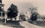
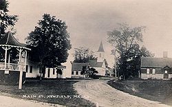
Newfield, Maine
Encyclopedia
Newfield is a town
in York County
, Maine
, United States
. The population was 1,328 at the 2000 census. Home to Willowbrook Museum Village
, Newfield is part of the Portland
–South Portland
–Biddeford
metropolitan statistical area
.
Chief Sunday (or Wesumbe) to Francis Small
, a Kittery
trader. The price was two large Indian blanket
s, two gallons of rum
, two pounds of gunpowder
, four pounds of musket
balls and twenty strings of beads. The township was surveyed and first settled as Washington Plantation in 1778. A number of settlers had been soldiers in the Revolutionary War
. It was incorporated as Newfield on February 25, 1794, and by 1859, the population was 1,418.
The Little Ossipee River
runs through Newfield village and once provided water power to operate two gristmill
s, two lumber
mills, a barrel stave
mill, a shook mill, a planing mill
and a carding
mill. West Newfield had a sawmill
, gristmill and stave mill. There was an attempt in the community to mine
silver
and iron
, but it was not profitable. By 1880, the population was 995. Newfield would be heavily damaged by the Great Fires of 1947.
Don King of Topsfield, Massachusetts
bought an old farm at Newfield in 1965, marking the beginning of what would become Willowbrook Museum Village, a re-created 19th-century village. Other properties and historic buildings were added, together with a collection of early farm implements, tools, carriage
s and sleighs. The museum is now a tourist attraction.
On March 17, 2009, Newfield adopted a local law to stop Nestlé
and other corporations from taking over their groundwater
. The volunteer community organization, Protecting Our Water and Wildlife Resources (POWWR), with the assistance of Community Environmental Legal Defense Fund (CELDF) who drafted the ordinance, were responsible for advocating the legislation.
, the town has a total area of 33.5 square miles (86.8 km²), of which, 32.3 square miles (83.7 km²) of it is land and 1.1 square miles (2.8 km²) of it is water
. The total area is 3.44% water. Newfield is drained by the Little Ossipee River
.
The town is crossed by state routes 11 and 110
. Newfield borders the towns of Parsonsfield
to its north, Limerick
and Waterboro
to its east, Wakefield
, New Hampshire
to its west, and Acton
and Shapleigh
to its south.
 As of the census
of 2000, there were 1,328 people, 496 households, and 370 families residing in the town. The population density
was 41.1 people per square mile (15.9/km²). There were 939 housing units at an average density of 29.1 per square mile (11.2/km²). The racial makeup of the town was 97.89% White, 0.08% African American, 0.90% Native American, 0.08% Asian, 0.15% from other races
, and 0.90% from two or more races. Hispanic or Latino of any race were 0.68% of the population.
There were 496 households out of which 35.5% had children under the age of 18 living with them, 63.7% were married couples
living together, 6.9% had a female householder with no husband present, and 25.4% were non-families. 19.2% of all households were made up of individuals and 6.9% had someone living alone who was 65 years of age or older. The average household size was 2.67 and the average family size was 3.02.
In the town the population was spread out with 26.4% under the age of 18, 6.3% from 18 to 24, 29.0% from 25 to 44, 27.1% from 45 to 64, and 11.3% who were 65 years of age or older. The median age was 39 years. For every 100 females there were 106.5 males. For every 100 females age 18 and over, there were 105.5 males.
The median income for a household in the town was $38,654, and the median income for a family was $41,563. Males had a median income of $30,403 versus $24,688 for females. The per capita income
for the town was $16,280. About 8.0% of families and 10.4% of the population were below the poverty line, including 10.0% of those under age 18 and 11.8% of those age 65 or over.
in Waterboro
.
New England town
The New England town is the basic unit of local government in each of the six New England states. Without a direct counterpart in most other U.S. states, New England towns are conceptually similar to civil townships in other states, but are incorporated, possessing powers like cities in other...
in York County
York County, Maine
York County is a county located in the U.S. state of Maine. In 2010, the population was 197,131. Its county seat is Alfred.Founded in 1636, it is the oldest county in Maine and one of the oldest in the United States....
, Maine
Maine
Maine is a state in the New England region of the northeastern United States, bordered by the Atlantic Ocean to the east and south, New Hampshire to the west, and the Canadian provinces of Quebec to the northwest and New Brunswick to the northeast. Maine is both the northernmost and easternmost...
, United States
United States
The United States of America is a federal constitutional republic comprising fifty states and a federal district...
. The population was 1,328 at the 2000 census. Home to Willowbrook Museum Village
Willowbrook Museum Village
19th Century Willowbrook Village is a U.S. museum on approximately with 34 buildings including two historic houses covering of the property. The museum is located in the town of Newfield, Maine. It is open 10 a.m...
, Newfield is part of the Portland
Portland, Maine
Portland is the largest city in Maine and is the county seat of Cumberland County. The 2010 city population was 66,194, growing 3 percent since the census of 2000...
–South Portland
South Portland, Maine
South Portland is a city in Cumberland County, Maine, United States, and is the fourth-largest city in the state. Founded in 1895, as of the 2010 census, the city population was 25,002. Known for its working waterfront, South Portland is situated on Portland Harbor and overlooks the skyline of...
–Biddeford
Biddeford, Maine
Biddeford is a town in York County, Maine, United States. It is the largest town in the county, and is the sixth-largest in the state. It is the most southerly incorporated town in the state and the principal commercial center of York County. The population was 21,277 at the 2010 census...
metropolitan statistical area
Portland-South Portland-Biddeford metropolitan area
The Portland–South Portland–Biddeford Metropolitan Statistical Area, also known as Greater Portland, as defined by the United States Census Bureau, is an area consisting of three counties in Maine, anchored by the city of Portland and the smaller cities of South Portland and Biddeford...
.
History
This was part of the large tract sold on November 28, 1668 by Newichawannock IndianIndigenous peoples of the Americas
The indigenous peoples of the Americas are the pre-Columbian inhabitants of North and South America, their descendants and other ethnic groups who are identified with those peoples. Indigenous peoples are known in Canada as Aboriginal peoples, and in the United States as Native Americans...
Chief Sunday (or Wesumbe) to Francis Small
Francis Small
Francis Small was an enterprising trader and landowner residing primarily in Kittery, Maine. He made the first recorded land purchase in what is now Maine, and proceeded to amass so much that he was called "the great landholder." He possessed the largest number of acres of anyone who ever lived...
, a Kittery
Kittery, Maine
Kittery is a town in York County, Maine, United States. The population was 9,543 at the 2000 census. Home to the Portsmouth Naval Shipyard on Seavey's Island, Kittery includes Badger's Island, the seaside district of Kittery Point, and part of the Isles of Shoals...
trader. The price was two large Indian blanket
Blanket
A blanket is a type of bedding, generally speaking, a large piece of cloth, intended to keep the user warm, especially while sleeping. Blankets are distinguished from sheets by their thickness and purpose; the thickest sheet is still thinner than the lightest blanket. Blankets are generally used...
s, two gallons of rum
Rum
Rum is a distilled alcoholic beverage made from sugarcane by-products such as molasses, or directly from sugarcane juice, by a process of fermentation and distillation. The distillate, a clear liquid, is then usually aged in oak barrels...
, two pounds of gunpowder
Gunpowder
Gunpowder, also known since in the late 19th century as black powder, was the first chemical explosive and the only one known until the mid 1800s. It is a mixture of sulfur, charcoal, and potassium nitrate - with the sulfur and charcoal acting as fuels, while the saltpeter works as an oxidizer...
, four pounds of musket
Musket
A musket is a muzzle-loaded, smooth bore long gun, fired from the shoulder. Muskets were designed for use by infantry. A soldier armed with a musket had the designation musketman or musketeer....
balls and twenty strings of beads. The township was surveyed and first settled as Washington Plantation in 1778. A number of settlers had been soldiers in the Revolutionary War
American Revolutionary War
The American Revolutionary War , the American War of Independence, or simply the Revolutionary War, began as a war between the Kingdom of Great Britain and thirteen British colonies in North America, and ended in a global war between several European great powers.The war was the result of the...
. It was incorporated as Newfield on February 25, 1794, and by 1859, the population was 1,418.
The Little Ossipee River
Little Ossipee River
The Little Ossipee River is a tributary of the Saco River in southwestern Maine.It rises at the outlet of Balch Pond in the town of Newfield and flows east, passing through Shapleigh Pond and flowing past the village of North Shapleigh. Forming the boundary between Newfield and the town of...
runs through Newfield village and once provided water power to operate two gristmill
Gristmill
The terms gristmill or grist mill can refer either to a building in which grain is ground into flour, or to the grinding mechanism itself.- Early history :...
s, two lumber
Lumber
Lumber or timber is wood in any of its stages from felling through readiness for use as structural material for construction, or wood pulp for paper production....
mills, a barrel stave
Barrel
A barrel or cask is a hollow cylindrical container, traditionally made of vertical wooden staves and bound by wooden or metal hoops. Traditionally, the barrel was a standard size of measure referring to a set capacity or weight of a given commodity. A small barrel is called a keg.For example, a...
mill, a shook mill, a planing mill
Planing mill
A planing mill is a facility that takes cut and seasoned boards from a sawmill and turns them into finished dimensional lumber. Machines used in the mill include the planer and matcher, the molding machines, and varieties of saws...
and a carding
Carding
Carding is a mechanical process that breaks up locks and unorganised clumps of fibre and then aligns the individual fibres so that they are more or less parallel with each other. The word is derived from the Latin carduus meaning teasel, as dried vegetable teasels were first used to comb the raw wool...
mill. West Newfield had a sawmill
Sawmill
A sawmill is a facility where logs are cut into boards.-Sawmill process:A sawmill's basic operation is much like those of hundreds of years ago; a log enters on one end and dimensional lumber exits on the other end....
, gristmill and stave mill. There was an attempt in the community to mine
Mining
Mining is the extraction of valuable minerals or other geological materials from the earth, from an ore body, vein or seam. The term also includes the removal of soil. Materials recovered by mining include base metals, precious metals, iron, uranium, coal, diamonds, limestone, oil shale, rock...
silver
Silver
Silver is a metallic chemical element with the chemical symbol Ag and atomic number 47. A soft, white, lustrous transition metal, it has the highest electrical conductivity of any element and the highest thermal conductivity of any metal...
and iron
Iron
Iron is a chemical element with the symbol Fe and atomic number 26. It is a metal in the first transition series. It is the most common element forming the planet Earth as a whole, forming much of Earth's outer and inner core. It is the fourth most common element in the Earth's crust...
, but it was not profitable. By 1880, the population was 995. Newfield would be heavily damaged by the Great Fires of 1947.
Don King of Topsfield, Massachusetts
Topsfield, Massachusetts
Topsfield is a town in Essex County, Massachusetts, United States. The population was 6,085 at the 2010 census.Part of the town comprises the census-designated place of Topsfield.-Colonial period:...
bought an old farm at Newfield in 1965, marking the beginning of what would become Willowbrook Museum Village, a re-created 19th-century village. Other properties and historic buildings were added, together with a collection of early farm implements, tools, carriage
Carriage
A carriage is a wheeled vehicle for people, usually horse-drawn; litters and sedan chairs are excluded, since they are wheelless vehicles. The carriage is especially designed for private passenger use and for comfort or elegance, though some are also used to transport goods. It may be light,...
s and sleighs. The museum is now a tourist attraction.
On March 17, 2009, Newfield adopted a local law to stop Nestlé
Nestlé
Nestlé S.A. is the world's largest food and nutrition company. Founded and headquartered in Vevey, Switzerland, Nestlé originated in a 1905 merger of the Anglo-Swiss Milk Company, established in 1867 by brothers George Page and Charles Page, and Farine Lactée Henri Nestlé, founded in 1866 by Henri...
and other corporations from taking over their groundwater
Groundwater
Groundwater is water located beneath the ground surface in soil pore spaces and in the fractures of rock formations. A unit of rock or an unconsolidated deposit is called an aquifer when it can yield a usable quantity of water. The depth at which soil pore spaces or fractures and voids in rock...
. The volunteer community organization, Protecting Our Water and Wildlife Resources (POWWR), with the assistance of Community Environmental Legal Defense Fund (CELDF) who drafted the ordinance, were responsible for advocating the legislation.
Geography
According to the United States Census BureauUnited States Census Bureau
The United States Census Bureau is the government agency that is responsible for the United States Census. It also gathers other national demographic and economic data...
, the town has a total area of 33.5 square miles (86.8 km²), of which, 32.3 square miles (83.7 km²) of it is land and 1.1 square miles (2.8 km²) of it is water
Water
Water is a chemical substance with the chemical formula H2O. A water molecule contains one oxygen and two hydrogen atoms connected by covalent bonds. Water is a liquid at ambient conditions, but it often co-exists on Earth with its solid state, ice, and gaseous state . Water also exists in a...
. The total area is 3.44% water. Newfield is drained by the Little Ossipee River
Little Ossipee River
The Little Ossipee River is a tributary of the Saco River in southwestern Maine.It rises at the outlet of Balch Pond in the town of Newfield and flows east, passing through Shapleigh Pond and flowing past the village of North Shapleigh. Forming the boundary between Newfield and the town of...
.
The town is crossed by state routes 11 and 110
Maine State Route 110
State Route 110 is a short state highway in southwestern Maine, located entirely within the town of Newfield. Route 110 begins in the west at the New Hampshire state line less than a half-mile from New Hampshire Route 153, which connects via unnumbered Stevens Corner Road...
. Newfield borders the towns of Parsonsfield
Parsonsfield, Maine
Parsonsfield is a town in York County, Maine, United States. The population was 1,584 at the 2000 census. Parsonsfield includes the villages of Kezar Falls, Parsonsfield, and North, East and South Parsonsfield...
to its north, Limerick
Limerick, Maine
Limerick is a town in York County, Maine, United States. It is part of the Portland–South Portland–Biddeford, Maine metropolitan statistical area. The population was 2,240 at the 2000 census.-History:...
and Waterboro
Waterboro, Maine
Waterboro is a town in York County, Maine, United States. The population was 6,214 at the 2000 census. It is part of the Portland–South Portland–Biddeford, Maine metropolitan statistical area....
to its east, Wakefield
Wakefield, New Hampshire
Wakefield is a town in Carroll County, New Hampshire, United States. The population was 5,078 at the 2010 census. The town includes the villages of Wakefield Corner , East Wakefield, North Wakefield, Sanbornville, Union, Woodman and Province Lake...
, New Hampshire
New Hampshire
New Hampshire is a state in the New England region of the northeastern United States of America. The state was named after the southern English county of Hampshire. It is bordered by Massachusetts to the south, Vermont to the west, Maine and the Atlantic Ocean to the east, and the Canadian...
to its west, and Acton
Acton, Maine
Acton is a town in York County, Maine, United States. The population was 2,145 at the 2000 census. It includes the villages of Acton, Miller Corner and South Acton. The town is home to the Acton Fairground, which holds the Acton Fair every late summer...
and Shapleigh
Shapleigh, Maine
Shapleigh, pronounced "SHAP-lee", is a town in York County, Maine, United States which was incorporated as the state's 43rd town in 1785. The population was 2,326 at the 2000 census. Shapleigh is divided into the villages of North Shapleigh, Shapleigh Corner, Ross Corner and Emery Mills...
to its south.
Demographics
Census
A census is the procedure of systematically acquiring and recording information about the members of a given population. It is a regularly occurring and official count of a particular population. The term is used mostly in connection with national population and housing censuses; other common...
of 2000, there were 1,328 people, 496 households, and 370 families residing in the town. The population density
Population density
Population density is a measurement of population per unit area or unit volume. It is frequently applied to living organisms, and particularly to humans...
was 41.1 people per square mile (15.9/km²). There were 939 housing units at an average density of 29.1 per square mile (11.2/km²). The racial makeup of the town was 97.89% White, 0.08% African American, 0.90% Native American, 0.08% Asian, 0.15% from other races
Race (United States Census)
Race and ethnicity in the United States Census, as defined by the Federal Office of Management and Budget and the United States Census Bureau, are self-identification data items in which residents choose the race or races with which they most closely identify, and indicate whether or not they are...
, and 0.90% from two or more races. Hispanic or Latino of any race were 0.68% of the population.
There were 496 households out of which 35.5% had children under the age of 18 living with them, 63.7% were married couples
Marriage
Marriage is a social union or legal contract between people that creates kinship. It is an institution in which interpersonal relationships, usually intimate and sexual, are acknowledged in a variety of ways, depending on the culture or subculture in which it is found...
living together, 6.9% had a female householder with no husband present, and 25.4% were non-families. 19.2% of all households were made up of individuals and 6.9% had someone living alone who was 65 years of age or older. The average household size was 2.67 and the average family size was 3.02.
In the town the population was spread out with 26.4% under the age of 18, 6.3% from 18 to 24, 29.0% from 25 to 44, 27.1% from 45 to 64, and 11.3% who were 65 years of age or older. The median age was 39 years. For every 100 females there were 106.5 males. For every 100 females age 18 and over, there were 105.5 males.
The median income for a household in the town was $38,654, and the median income for a family was $41,563. Males had a median income of $30,403 versus $24,688 for females. The per capita income
Per capita income
Per capita income or income per person is a measure of mean income within an economic aggregate, such as a country or city. It is calculated by taking a measure of all sources of income in the aggregate and dividing it by the total population...
for the town was $16,280. About 8.0% of families and 10.4% of the population were below the poverty line, including 10.0% of those under age 18 and 11.8% of those age 65 or over.
Education
The children of Newfield that are in grades K-5 attend Line Elementary School which is a part of Regional School Unit 57, on the Newfield-Limerick border shared with Limerick. Students in grades 6-8 attend Massabesic Middle School and students in grades 9-12 attend Massabesic High SchoolMassabesic High School
Massabesic High School, Pronounced "MASS-UH-BEE-SlK" is a public high school located in Waterboro, Maine, United States...
in Waterboro
Waterboro, Maine
Waterboro is a town in York County, Maine, United States. The population was 6,214 at the 2000 census. It is part of the Portland–South Portland–Biddeford, Maine metropolitan statistical area....
.
Sites of interest
- Newfield Historical Society & Museum
- Willowbrook Museum VillageWillowbrook Museum Village19th Century Willowbrook Village is a U.S. museum on approximately with 34 buildings including two historic houses covering of the property. The museum is located in the town of Newfield, Maine. It is open 10 a.m...
Notable residents
- Nathan CliffordNathan CliffordNathan Clifford was an American statesman, diplomat and jurist.Clifford was born of old Yankee stock in Rumney, New Hampshire, to farmers, the only son of seven children He attended the public schools of that town, then the Haverhill Academy in New...
, statesman, diplomat and jurist - Horace Parnell TuttleHorace Parnell TuttleHorace Parnell Tuttle was an American astronomer, a Civil War veteran and brother of astronomer Charles Wesley Tuttle ....
, astronomer