
Parsonsfield, Maine
Encyclopedia
Parsonsfield is a town
in York County
, Maine
, United States
. The population was 1,584 at the 2000 census. Parsonsfield includes the villages of Kezar Falls
, Parsonsfield, and North, East and South Parsonsfield. It is part of the Portland
–South Portland
–Biddeford
, Maine metropolitan statistical area
.
Chief Sunday (or Wesumbe) to Francis Small
, a trader from Kittery
. The price was two large Indian blankets, two gallons of rum
, two pounds of gunpowder
, four pounds of musket
balls and twenty strings of Indian beads. Small then sold half his interest to Major Nicholas Shapleigh of what is now Eliot
. In 1771, heirs sold the township to Thomas Parsons and 39 associates, upon which it was surveyed into 100 acre (0.404686 km²) lots. Called Parsonstown Plantation, it was first settled in 1772 by 12 families.
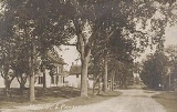
On August 29, 1785, the town was incorporated as Parsonsfield after Thomas Parsons, one of the largest proprietors. The Blazo-Leavitt House
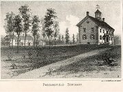
, a fine example of the Federal style, was built in 1812. Parsonsfield Seminary
was founded in 1832, but would close in 1949.
The surface of the town is rough and hilly, its soil rocky but fertile for farming. Chief crops were grain
and hay
. Mills
were built at pond outlets and on the South River
. The largest water power source was on the Ossipee River
at Kezar Falls, where the village of Kezar Falls straddled the stream into Porter
. Parsonsfield had seven sawmill
s and seven gristmill
s. In 1880, John Devereux and George W. Towle built the Kezar Falls Woolen Mill, a woolen
textile
factory which became the most important business in Parsonsfield.
, the town has a total area of 60 square miles (155.4 km²), of which, 59 square miles (152.8 km²) of it is land and 1.1 square miles (2.8 km²) of it (1.78%) is water. Parsonsfield is drained by the South River
and Ossipee River
.
The town is crossed by state routes 25 and 160. It is bordered by Effingham
and Wakefield, New Hampshire
to the west, Porter
and Hiram
to the north, Cornish
and Limerick
to the east, and Newfield
to the south.
of 2000, there were 1,584 people, 634 households, and 438 families residing in the town. The population density
was 26.9 people per square mile (10.4/km²). There were 996 housing units at an average density of 16.9 per square mile (6.5/km²). The racial makeup of the town was 98.17% White, 0.13% African American, 0.25% Native American, 0.19% Asian, 0.06% from other races
, and 1.20% from two or more races. Hispanic or Latino of any race were 0.82% of the population.
There were 634 households out of which 30.6% had children under the age of 18 living with them, 54.7% were married couples
living together, 9.3% had a female householder with no husband present, and 30.8% were non-families. 24.3% of all households were made up of individuals and 10.6% had someone living alone who was 65 years of age or older. The average household size was 2.48 and the average family size was 2.89.
In the town the population was spread out with 25.4% under the age of 18, 5.8% from 18 to 24, 28.2% from 25 to 44, 25.3% from 45 to 64, and 15.3% who were 65 years of age or older. The median age was 39 years. For every 100 females there were 99.7 males. For every 100 females age 18 and over, there were 96.8 males.
The median income for a household in the town was $32,214, and the median income for a family was $36,016. Males had a median income of $30,815 versus $20,917 for females. The per capita income
for the town was $16,968. About 10.5% of families and 12.1% of the population were below the poverty line, including 14.0% of those under age 18 and 9.4% of those age 65 or over.
The town of Parsonsfield is in the extreme northwest corner of York County, Maine. Center Square, on the northern slope of Cedar Mountain, is about 30 miles (50 km) from the ocean, at Old Orchard and thirty-two from Wells Beach on an air line, and 33 miles (55 km) west-north-west from Portland.
Its northern boundary is the Great Ossipee River
(Ossipee signifies "River of Pines" in the Indian dialect.) The towns of Porter
and Hiram
are north of the river. Effingham
and Wakefield, NH
, are on the western border, Newfield
is on the south, Limerick
and Cornish
on the east. The outer lines of the town have been measured several times, giving an area from 62.23 to 64 square miles (161 to 166 km²). The length of the western line is nearly 8.5 miles (13.7 km), the eastern something over 9 miles (14 km), the northern and southern about 7.3 miles (12 km).
The surface of Parsonsfield is quite broken, or more properly, rises into high swells. Ricker's Mountain, in the southwest, is the highest, it being not far from 1,600 feet (488 m) above the level of the sea. Cedar Mountain, in the center, comes up within one hundred feet of Ricker's, while Randall's Mountain in the east, may fall 100 feet (30 m) below Cedar. The Seminary varies but little from 1,200 feet (366 m) above sea level, while the average altitude of the town is estimated at 1,000 feet (300 m). After Parsonsfield Seminary
burned in 1854, Bates College
was founded as a replacement.
Ricker's Mountain takes its name from Dea. Dominicus Ricker, who lived and died near the summit. Cedar is so called from the mountain cedar growing there. A legend tells how a hunter named Randall perished from cold on the mountain called by his name. Another tradition goes something like this: "Many years ago a famous hunter, named Randall, hunted hereaway among these mountains and caught much game. He usually reposed on the top of the high mountain by the rivulet, where it is supposed he was murdered by another hunter for his furs. The supposed murderer was absent only a few days from the settlements and returned heavily laden with valuable skins."
The high ridge, of which Cedar Mountain is the apex, runs east and west across the town. It is the water-shed, or divide, between the Great and Little Ossipee Rivers. The town is dotted all over with hills and swells, some of them hard to climb, but generally productive.
The principal river is the Great Ossipee. By estimation, the average yearly discharge is nine billion cubic feet (8 m³/s), the length 33 miles (53 km), draining an area of about 240 square miles (621.6 km²). There is an excellent water power at Kezar Falls, the descent being 50 feet (15.2 m) per mile (9 m/km).
South River
is next in size. It enters the Ossipee above Porter Bridge. The privilege at Lord's mills is the best within the town. The Bickford and Blaisdall mill streams run into the Little Ossipee. Smaller brooks are found in all parts of the town. It would be hard to find a lot of land not having one or more living springs, and as many never failing rivulets.
A small part of Province Pond
is in Parsonsfield. The state line is one-fourth of a mile (400 m) from the eastern shore, and the distance across, by that line, is about one mile (1.6 km). Long Pond, in the northeast, is a beautiful sheet of water, 1.5 miles (2.4 km) long, and about one-third (800 m) that in width. West Pond, separated from Long Pond by a ridge, is nearly half as large. Smaller ponds are found among the hills.
Coarse granite rock projects here and there, but surface ledges cover only a small part of the town. Less than half the wells extend down to the rock bed. The prevailing soil may be denominated granite. There are patches of sand, but clay, even of inferior quality, is scarce. From one to two feet (300 to 600 mm) below the surface there is a hard pan or subsoil.
There are but few swamps or bog meadows, for the reason that the surface is tilted this, that, and every way, but valuable intervales lie along the brooks and rivers.
There are very few farms without stones enough to fence them. A large surplus of this imperishable fence material is the rule.
The original forest growth was maple, beech, hemlock, pine, birch, oak, and ash, with scores of other trees interspersed. Each variety prevailing in its favored locality, but not holding exclusive possession of a single farm. Where a second growth has been allowed to spring up, the soft woods in many cases have succeeded the hard, while the hard has been followed by soft. It is known that the present growth is a little more mixed than the first.
Since people made a break in the forest, there have been some climatic changes. Winter weather is more variable. Summer days are hotter and droughts more severe.
Roughly 20 percent of the town of Parsonsfield falls within the 8603 acres (34.8 km²) Leavitt Plantation Forest, the largest contiguous block of forest land south of Sebago Lake. When the tract of forest was slated to be sold into smaller parcels, the Nature Conservancy and the state of Maine intervened, purchasing a conservation easement on the entire parcel and keeping it intact. That easement will protect Leavitt Plantation in perpetuity, while allowing sustainable forestry practices.
New England town
The New England town is the basic unit of local government in each of the six New England states. Without a direct counterpart in most other U.S. states, New England towns are conceptually similar to civil townships in other states, but are incorporated, possessing powers like cities in other...
in York County
York County, Maine
York County is a county located in the U.S. state of Maine. In 2010, the population was 197,131. Its county seat is Alfred.Founded in 1636, it is the oldest county in Maine and one of the oldest in the United States....
, Maine
Maine
Maine is a state in the New England region of the northeastern United States, bordered by the Atlantic Ocean to the east and south, New Hampshire to the west, and the Canadian provinces of Quebec to the northwest and New Brunswick to the northeast. Maine is both the northernmost and easternmost...
, United States
United States
The United States of America is a federal constitutional republic comprising fifty states and a federal district...
. The population was 1,584 at the 2000 census. Parsonsfield includes the villages of Kezar Falls
Kezar Falls, Maine
Kezar Falls is a small village on the Ossipee River in the town of Porter in Oxford County, Maine, United States.- External links :...
, Parsonsfield, and North, East and South Parsonsfield. It is part of the Portland
Portland, Maine
Portland is the largest city in Maine and is the county seat of Cumberland County. The 2010 city population was 66,194, growing 3 percent since the census of 2000...
–South Portland
South Portland, Maine
South Portland is a city in Cumberland County, Maine, United States, and is the fourth-largest city in the state. Founded in 1895, as of the 2010 census, the city population was 25,002. Known for its working waterfront, South Portland is situated on Portland Harbor and overlooks the skyline of...
–Biddeford
Biddeford, Maine
Biddeford is a town in York County, Maine, United States. It is the largest town in the county, and is the sixth-largest in the state. It is the most southerly incorporated town in the state and the principal commercial center of York County. The population was 21,277 at the 2010 census...
, Maine metropolitan statistical area
Portland-South Portland-Biddeford metropolitan area
The Portland–South Portland–Biddeford Metropolitan Statistical Area, also known as Greater Portland, as defined by the United States Census Bureau, is an area consisting of three counties in Maine, anchored by the city of Portland and the smaller cities of South Portland and Biddeford...
.
History
This was part of a large tract of land sold on November 28, 1668 by Newichewannock IndianIndigenous peoples of the Americas
The indigenous peoples of the Americas are the pre-Columbian inhabitants of North and South America, their descendants and other ethnic groups who are identified with those peoples. Indigenous peoples are known in Canada as Aboriginal peoples, and in the United States as Native Americans...
Chief Sunday (or Wesumbe) to Francis Small
Francis Small
Francis Small was an enterprising trader and landowner residing primarily in Kittery, Maine. He made the first recorded land purchase in what is now Maine, and proceeded to amass so much that he was called "the great landholder." He possessed the largest number of acres of anyone who ever lived...
, a trader from Kittery
Kittery, Maine
Kittery is a town in York County, Maine, United States. The population was 9,543 at the 2000 census. Home to the Portsmouth Naval Shipyard on Seavey's Island, Kittery includes Badger's Island, the seaside district of Kittery Point, and part of the Isles of Shoals...
. The price was two large Indian blankets, two gallons of rum
Rum
Rum is a distilled alcoholic beverage made from sugarcane by-products such as molasses, or directly from sugarcane juice, by a process of fermentation and distillation. The distillate, a clear liquid, is then usually aged in oak barrels...
, two pounds of gunpowder
Gunpowder
Gunpowder, also known since in the late 19th century as black powder, was the first chemical explosive and the only one known until the mid 1800s. It is a mixture of sulfur, charcoal, and potassium nitrate - with the sulfur and charcoal acting as fuels, while the saltpeter works as an oxidizer...
, four pounds of musket
Musket
A musket is a muzzle-loaded, smooth bore long gun, fired from the shoulder. Muskets were designed for use by infantry. A soldier armed with a musket had the designation musketman or musketeer....
balls and twenty strings of Indian beads. Small then sold half his interest to Major Nicholas Shapleigh of what is now Eliot
Eliot, Maine
Eliot is a town in York County, Maine, United States. The population was 6,204 at the 2010 census. It is part of the Portland–South Portland–Biddeford, Maine metropolitan statistical area....
. In 1771, heirs sold the township to Thomas Parsons and 39 associates, upon which it was surveyed into 100 acre (0.404686 km²) lots. Called Parsonstown Plantation, it was first settled in 1772 by 12 families.
On August 29, 1785, the town was incorporated as Parsonsfield after Thomas Parsons, one of the largest proprietors. The Blazo-Leavitt House
Blazo-Leavitt House
The Blazo-Leavitt House is a large two-story white-clapboard mansion built in Parsonsfield, Maine, in 1812.-History:The Blazo-Leavitt House is a large two-story white-clapboard mansion[1] built in Parsonsfield, Maine, in 1812 by William Blazo, uncle to prominent Parsonsfield lawyer Robert Tibbetts...
, a fine example of the Federal style, was built in 1812. Parsonsfield Seminary
Parsonsfield Seminary
Parsonsfield Seminary, which operated from 1832-1949, was a well-known Free Will Baptist school in North Parsonsfield, Maine, in the United States. Also known as the North Parsonsfield Seminary, its preserved campus of four buildings is located on State Route 160.-History:In 1832 Rev. John Buzzell...
was founded in 1832, but would close in 1949.
The surface of the town is rough and hilly, its soil rocky but fertile for farming. Chief crops were grain
GRAIN
GRAIN is a small international non-profit organisation that works to support small farmers and social movements in their struggles for community-controlled and biodiversity-based food systems. Our support takes the form of independent research and analysis, networking at local, regional and...
and hay
Hay
Hay is grass, legumes or other herbaceous plants that have been cut, dried, and stored for use as animal fodder, particularly for grazing livestock such as cattle, horses, goats, and sheep. Hay is also fed to pets such as rabbits and guinea pigs...
. Mills
Watermill
A watermill is a structure that uses a water wheel or turbine to drive a mechanical process such as flour, lumber or textile production, or metal shaping .- History :...
were built at pond outlets and on the South River
South River (Ossipee River)
The South River is a 10.6 mile long river in eastern New Hampshire and western Maine in the United States. It is a tributary of the Ossipee River, which flows east to the Saco River and ultimately the Atlantic Ocean....
. The largest water power source was on the Ossipee River
Ossipee River
The Ossipee River is an river in eastern New Hampshire and western Maine in the United States. It is a tributary of the Saco River, which flows southeast to the Atlantic Ocean at Saco, Maine....
at Kezar Falls, where the village of Kezar Falls straddled the stream into Porter
Porter, Maine
Porter is a town in Oxford County, Maine, United States. It is included in the Portland-South Portland-Biddeford, Maine metropolitan New England City and Town Area. Porter includes Porter village and part of Kezar Falls. The population was 1,438 at the 2000 census.-History:The land was once...
. Parsonsfield had seven sawmill
Sawmill
A sawmill is a facility where logs are cut into boards.-Sawmill process:A sawmill's basic operation is much like those of hundreds of years ago; a log enters on one end and dimensional lumber exits on the other end....
s and seven gristmill
Gristmill
The terms gristmill or grist mill can refer either to a building in which grain is ground into flour, or to the grinding mechanism itself.- Early history :...
s. In 1880, John Devereux and George W. Towle built the Kezar Falls Woolen Mill, a woolen
Woolen
Woolen or woollen is a type of yarn made from carded wool. Woolen yarn is soft, light, stretchy, and full of air. It is thus a good insulator, and makes a good knitting yarn...
textile
Textile
A textile or cloth is a flexible woven material consisting of a network of natural or artificial fibres often referred to as thread or yarn. Yarn is produced by spinning raw fibres of wool, flax, cotton, or other material to produce long strands...
factory which became the most important business in Parsonsfield.
Geography
According to the United States Census BureauUnited States Census Bureau
The United States Census Bureau is the government agency that is responsible for the United States Census. It also gathers other national demographic and economic data...
, the town has a total area of 60 square miles (155.4 km²), of which, 59 square miles (152.8 km²) of it is land and 1.1 square miles (2.8 km²) of it (1.78%) is water. Parsonsfield is drained by the South River
South River (Ossipee River)
The South River is a 10.6 mile long river in eastern New Hampshire and western Maine in the United States. It is a tributary of the Ossipee River, which flows east to the Saco River and ultimately the Atlantic Ocean....
and Ossipee River
Ossipee River
The Ossipee River is an river in eastern New Hampshire and western Maine in the United States. It is a tributary of the Saco River, which flows southeast to the Atlantic Ocean at Saco, Maine....
.
The town is crossed by state routes 25 and 160. It is bordered by Effingham
Effingham, New Hampshire
Effingham is a town in Carroll County, New Hampshire, United States. As of the 2010 census, the town population was 1,465. Effingham includes the villages of Effingham Falls, Effingham , Center Effingham , and South Effingham...
and Wakefield, New Hampshire
Wakefield, New Hampshire
Wakefield is a town in Carroll County, New Hampshire, United States. The population was 5,078 at the 2010 census. The town includes the villages of Wakefield Corner , East Wakefield, North Wakefield, Sanbornville, Union, Woodman and Province Lake...
to the west, Porter
Porter, Maine
Porter is a town in Oxford County, Maine, United States. It is included in the Portland-South Portland-Biddeford, Maine metropolitan New England City and Town Area. Porter includes Porter village and part of Kezar Falls. The population was 1,438 at the 2000 census.-History:The land was once...
and Hiram
Hiram, Maine
Hiram is a town in Oxford County, Maine, United States. The population was 1,423 at the 2000 census. It includes the villages of Hiram, East Hiram, South Hiram and Durgintown...
to the north, Cornish
Cornish, Maine
Cornish is a town in York County, Maine, United States. The population was 1,269 at the 2000 census. It is part of the Portland–South Portland–Biddeford, Maine metropolitan statistical area...
and Limerick
Limerick, Maine
Limerick is a town in York County, Maine, United States. It is part of the Portland–South Portland–Biddeford, Maine metropolitan statistical area. The population was 2,240 at the 2000 census.-History:...
to the east, and Newfield
Newfield, Maine
Newfield is a town in York County, Maine, United States. The population was 1,328 at the 2000 census. Home to Willowbrook Museum Village, Newfield is part of the Portland–South Portland–Biddeford metropolitan statistical area.-History:...
to the south.
Demographics
As of the censusCensus
A census is the procedure of systematically acquiring and recording information about the members of a given population. It is a regularly occurring and official count of a particular population. The term is used mostly in connection with national population and housing censuses; other common...
of 2000, there were 1,584 people, 634 households, and 438 families residing in the town. The population density
Population density
Population density is a measurement of population per unit area or unit volume. It is frequently applied to living organisms, and particularly to humans...
was 26.9 people per square mile (10.4/km²). There were 996 housing units at an average density of 16.9 per square mile (6.5/km²). The racial makeup of the town was 98.17% White, 0.13% African American, 0.25% Native American, 0.19% Asian, 0.06% from other races
Race (United States Census)
Race and ethnicity in the United States Census, as defined by the Federal Office of Management and Budget and the United States Census Bureau, are self-identification data items in which residents choose the race or races with which they most closely identify, and indicate whether or not they are...
, and 1.20% from two or more races. Hispanic or Latino of any race were 0.82% of the population.
There were 634 households out of which 30.6% had children under the age of 18 living with them, 54.7% were married couples
Marriage
Marriage is a social union or legal contract between people that creates kinship. It is an institution in which interpersonal relationships, usually intimate and sexual, are acknowledged in a variety of ways, depending on the culture or subculture in which it is found...
living together, 9.3% had a female householder with no husband present, and 30.8% were non-families. 24.3% of all households were made up of individuals and 10.6% had someone living alone who was 65 years of age or older. The average household size was 2.48 and the average family size was 2.89.
In the town the population was spread out with 25.4% under the age of 18, 5.8% from 18 to 24, 28.2% from 25 to 44, 25.3% from 45 to 64, and 15.3% who were 65 years of age or older. The median age was 39 years. For every 100 females there were 99.7 males. For every 100 females age 18 and over, there were 96.8 males.
The median income for a household in the town was $32,214, and the median income for a family was $36,016. Males had a median income of $30,815 versus $20,917 for females. The per capita income
Per capita income
Per capita income or income per person is a measure of mean income within an economic aggregate, such as a country or city. It is calculated by taking a measure of all sources of income in the aggregate and dividing it by the total population...
for the town was $16,968. About 10.5% of families and 12.1% of the population were below the poverty line, including 14.0% of those under age 18 and 9.4% of those age 65 or over.
Geographical description in 1888
Note: The following section is largely copied from the book "History of Parsonsfield, Maine: 1771-1888," published by Brown Thurston & Company, 1888.The town of Parsonsfield is in the extreme northwest corner of York County, Maine. Center Square, on the northern slope of Cedar Mountain, is about 30 miles (50 km) from the ocean, at Old Orchard and thirty-two from Wells Beach on an air line, and 33 miles (55 km) west-north-west from Portland.
Its northern boundary is the Great Ossipee River
Ossipee River
The Ossipee River is an river in eastern New Hampshire and western Maine in the United States. It is a tributary of the Saco River, which flows southeast to the Atlantic Ocean at Saco, Maine....
(Ossipee signifies "River of Pines" in the Indian dialect.) The towns of Porter
Porter, Maine
Porter is a town in Oxford County, Maine, United States. It is included in the Portland-South Portland-Biddeford, Maine metropolitan New England City and Town Area. Porter includes Porter village and part of Kezar Falls. The population was 1,438 at the 2000 census.-History:The land was once...
and Hiram
Hiram, Maine
Hiram is a town in Oxford County, Maine, United States. The population was 1,423 at the 2000 census. It includes the villages of Hiram, East Hiram, South Hiram and Durgintown...
are north of the river. Effingham
Effingham, New Hampshire
Effingham is a town in Carroll County, New Hampshire, United States. As of the 2010 census, the town population was 1,465. Effingham includes the villages of Effingham Falls, Effingham , Center Effingham , and South Effingham...
and Wakefield, NH
Wakefield, New Hampshire
Wakefield is a town in Carroll County, New Hampshire, United States. The population was 5,078 at the 2010 census. The town includes the villages of Wakefield Corner , East Wakefield, North Wakefield, Sanbornville, Union, Woodman and Province Lake...
, are on the western border, Newfield
Newfield, Maine
Newfield is a town in York County, Maine, United States. The population was 1,328 at the 2000 census. Home to Willowbrook Museum Village, Newfield is part of the Portland–South Portland–Biddeford metropolitan statistical area.-History:...
is on the south, Limerick
Limerick, Maine
Limerick is a town in York County, Maine, United States. It is part of the Portland–South Portland–Biddeford, Maine metropolitan statistical area. The population was 2,240 at the 2000 census.-History:...
and Cornish
Cornish, Maine
Cornish is a town in York County, Maine, United States. The population was 1,269 at the 2000 census. It is part of the Portland–South Portland–Biddeford, Maine metropolitan statistical area...
on the east. The outer lines of the town have been measured several times, giving an area from 62.23 to 64 square miles (161 to 166 km²). The length of the western line is nearly 8.5 miles (13.7 km), the eastern something over 9 miles (14 km), the northern and southern about 7.3 miles (12 km).
The surface of Parsonsfield is quite broken, or more properly, rises into high swells. Ricker's Mountain, in the southwest, is the highest, it being not far from 1,600 feet (488 m) above the level of the sea. Cedar Mountain, in the center, comes up within one hundred feet of Ricker's, while Randall's Mountain in the east, may fall 100 feet (30 m) below Cedar. The Seminary varies but little from 1,200 feet (366 m) above sea level, while the average altitude of the town is estimated at 1,000 feet (300 m). After Parsonsfield Seminary
Parsonsfield Seminary
Parsonsfield Seminary, which operated from 1832-1949, was a well-known Free Will Baptist school in North Parsonsfield, Maine, in the United States. Also known as the North Parsonsfield Seminary, its preserved campus of four buildings is located on State Route 160.-History:In 1832 Rev. John Buzzell...
burned in 1854, Bates College
Bates College
Bates College is a highly selective, private liberal arts college located in Lewiston, Maine, in the United States. and was most recently ranked 21st in the nation in the 2011 US News Best Liberal Arts Colleges rankings. The college was founded in 1855 by abolitionists...
was founded as a replacement.
Ricker's Mountain takes its name from Dea. Dominicus Ricker, who lived and died near the summit. Cedar is so called from the mountain cedar growing there. A legend tells how a hunter named Randall perished from cold on the mountain called by his name. Another tradition goes something like this: "Many years ago a famous hunter, named Randall, hunted hereaway among these mountains and caught much game. He usually reposed on the top of the high mountain by the rivulet, where it is supposed he was murdered by another hunter for his furs. The supposed murderer was absent only a few days from the settlements and returned heavily laden with valuable skins."
The high ridge, of which Cedar Mountain is the apex, runs east and west across the town. It is the water-shed, or divide, between the Great and Little Ossipee Rivers. The town is dotted all over with hills and swells, some of them hard to climb, but generally productive.
The principal river is the Great Ossipee. By estimation, the average yearly discharge is nine billion cubic feet (8 m³/s), the length 33 miles (53 km), draining an area of about 240 square miles (621.6 km²). There is an excellent water power at Kezar Falls, the descent being 50 feet (15.2 m) per mile (9 m/km).
South River
South River (Ossipee River)
The South River is a 10.6 mile long river in eastern New Hampshire and western Maine in the United States. It is a tributary of the Ossipee River, which flows east to the Saco River and ultimately the Atlantic Ocean....
is next in size. It enters the Ossipee above Porter Bridge. The privilege at Lord's mills is the best within the town. The Bickford and Blaisdall mill streams run into the Little Ossipee. Smaller brooks are found in all parts of the town. It would be hard to find a lot of land not having one or more living springs, and as many never failing rivulets.
A small part of Province Pond
Province Lake
Province Lake is a water body located on the border between New Hampshire and Maine in the United States. Approximately of the lake lie in the towns of Effingham and Wakefield, New Hampshire, with the remainder in Parsonsfield, Maine...
is in Parsonsfield. The state line is one-fourth of a mile (400 m) from the eastern shore, and the distance across, by that line, is about one mile (1.6 km). Long Pond, in the northeast, is a beautiful sheet of water, 1.5 miles (2.4 km) long, and about one-third (800 m) that in width. West Pond, separated from Long Pond by a ridge, is nearly half as large. Smaller ponds are found among the hills.
Coarse granite rock projects here and there, but surface ledges cover only a small part of the town. Less than half the wells extend down to the rock bed. The prevailing soil may be denominated granite. There are patches of sand, but clay, even of inferior quality, is scarce. From one to two feet (300 to 600 mm) below the surface there is a hard pan or subsoil.
There are but few swamps or bog meadows, for the reason that the surface is tilted this, that, and every way, but valuable intervales lie along the brooks and rivers.
There are very few farms without stones enough to fence them. A large surplus of this imperishable fence material is the rule.
The original forest growth was maple, beech, hemlock, pine, birch, oak, and ash, with scores of other trees interspersed. Each variety prevailing in its favored locality, but not holding exclusive possession of a single farm. Where a second growth has been allowed to spring up, the soft woods in many cases have succeeded the hard, while the hard has been followed by soft. It is known that the present growth is a little more mixed than the first.
Since people made a break in the forest, there have been some climatic changes. Winter weather is more variable. Summer days are hotter and droughts more severe.
Roughly 20 percent of the town of Parsonsfield falls within the 8603 acres (34.8 km²) Leavitt Plantation Forest, the largest contiguous block of forest land south of Sebago Lake. When the tract of forest was slated to be sold into smaller parcels, the Nature Conservancy and the state of Maine intervened, purchasing a conservation easement on the entire parcel and keeping it intact. That easement will protect Leavitt Plantation in perpetuity, while allowing sustainable forestry practices.
Sites of interest
- Parsonsfield-Porter Bridge, a 2 span covered bridge built in 1876
- Parsonsfield-Porter Historical Society & Museum (in Porter)
Notable people
- James W. BradburyJames W. BradburyJames Ware Bradbury was a United States Senator from Maine.Born in Parsonsfield, Maine, he attended the common schools and Gorham Academy...
, senator - Contessa BrewerContessa BrewerContessa Brewer is an American host for the MSNBC weekend program Caught on Camera.-Biography:Brewer was born in in Parsonsfield, Maine, and graduated from Sacopee Valley High School in Hiram, Maine in 1992. She graduated magna cum laude from Syracuse University's Newhouse School of Public...
, news anchor - John BuzzellJohn BuzzellJohn Buzzell was an early proponent of the Free Will Baptist Church, a Christian author, and a preacher.John Buzzell was born in Barrington, New Hampshire in 1766. After befriending Benjamin Randall, Buzzell became a Free Will Baptist and was ordained a minister in 1792. He preached extensively...
, clergyman, writer - Oren B. CheneyOren B. CheneyOren Burbank Cheney was the founder of Bates College, an abolitionist, and a Free Will Baptist clergyman.-Early life:...
, clergyman, educator - Carolyn ChuteCarolyn ChuteCarolyn Chute is an American writer and populist political activist strongly identified with the culture of poor, rural western Maine...
, writer - Luther Orlando EmersonLuther Orlando Emerson-Biography:Emerson was born in Parsonsfield, Maine on August 3, 1820. He attended Parsonsfield Seminary and Effingham Academy, originally planning to be a doctor. Later he studied music under Isaac Woodbury. He taught for eight years in Salem, Massachusetts...
, musician, composer, music publisher - Charles Augustus HiltonCharles Augustus HiltonCharles Augustus Hilton was a Union soldier in the American Civil War and later became a Free Will Baptist preacher. Hilton, New York, a village in the town of Parma, was named after him in 1896. He was born on July 22, 1845 in Parsonsfield, Maine, the son of George and Abigail F Hilton, and died...
, preacher - Robert Greenleaf LeavittRobert Greenleaf LeavittDr. Robert Greenleaf Leavitt , born at Parsonsfield, Maine, was an early American Harvard-educated botanist and widely-published author in the field of botany, as well as an early college and high school educator in the natural sciences. Leavitt also worked for nine years as a botanical researcher...
, botanist - Rufus McIntireRufus McIntireRufus McIntire was a United States lawyer, captain of artillery in the War of 1812, congressman, land surveyor and prisoner of war.-Early life:...
, congressman - Daniel PageDaniel PageDaniel D. Page was the second mayor of St. Louis, Missouri, United States.Daniel Page was born in Parsonsfield, Maine in 1790. At the age of fifteen, he moved to Portland, Maine where he learned to be a baker, later setting up his own shop in Boston, Massachusetts. In Boston, he met and married...
, politician, businessman - Alzina Parson Stevens, labor leader
- Lorenzo De Medici SweatLorenzo De Medici SweatLorenzo De Medici Sweat was a U.S. Representative from Maine.He was born in Parsonsfield, Maine, where he attended Parsonsfield Seminary, a Freewill Baptist school. Sweat then attended Bowdoin College, from where he graduated in 1837. He graduated from Harvard University in 1840, having studied...
, congressman - Amos TuckAmos TuckAmos Tuck was a political figure in New Hampshire, credited by some New Hampshire sources as a founder of the Republican Party.-Early life and education:...
, congressman