
New York State Route 429
Encyclopedia
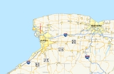
New York State Route 429 (NY 429) is a north–south state highway
located entirely within Niagara County, New York
, in the United States. It extends for 12.16 miles (19.57 km) from an intersection with NY 265
and NY 384
in North Tonawanda
to a junction with NY 104
(Ridge Road
) on the border between the towns of Cambria
and Lewiston
. Although it is relatively minor in length, the route is regionally important nonetheless as it connects North Tonawanda to some of the county's interior regions. About midway between North Tonawanda and Ridge Road, NY 429 serves the hamlet of Sanborn
, where it briefly overlaps with NY 31
. At Pekin
, a community situated between Sanborn and NY 104, NY 429 descends the Niagara Escarpment
.
The Sanborn – Ridge Road segment of modern NY 429 was originally designated as part of Route 30, an unsigned legislative route
, in 1908. In the mid-1920s, the portion of Route 30 west of Rochester
became part of the signed NY 31; however, NY 31 was realigned in the late 1920s to follow Ridge Road west from Cambria to the village of Lewiston. NY 31's former alignment from Niagara Falls
to Ridge Road via Sanborn became New York State Route 31A at this time. NY 31A was eliminated ca. 1935 as part of the establishment of U.S. Route 104 (US 104). The portion of its former routing north of Sanborn became part of the new NY 429, which was assigned to its current alignment upon assignment.
at a junction with NY 265
and NY 384
in downtown North Tonawanda
. The route heads east as Wheatfield Street, crossing the CSX Transportation
-owned Niagara Subdivision
at a grade crossing that separates an industrialized block of the street from more residential sections to the east. After three blocks, NY 429 turns onto Oliver Street and follows it northwestward through residential and industrial portions of the city, paralleling NY 265 and NY 384 for 1.5 miles (2.4 km) to a junction with Ward Road. Oliver Street and Ward Road merge here, and the combined street takes on the Ward Road name as it proceeds due northward through the solely residential northern portion of North Tonawanda. NY 429 exits the city near a junction with Ruie Road, at which point maintenance of the route shifts from the city to the New York State Department of Transportation
(NYSDOT).
Now in the town of Wheatfield
, NY 429 heads across populated but less developed areas on its way to a junction with US 62
. North of this point, the closely spaced homes gradually give way to more isolated houses and, eventually, rural farmland. It continues on a north–south line to the town of Lewiston
and the hamlet of Sanborn
, located adjacent to the Lewiston–Cambria
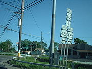
town line. In the small but developed community, NY 429 follows Buffalo Street past three blocks of homes to a junction with NY 31
(Saunders Settlement Road). Buffalo Street ends here; however, NY 429 joins
NY 31 for two blocks east to Townline Road, a north–south highway delimiting the boundary between Lewiston and Cambria. NY 429 continues north on Townline Road, passing the sprawling main campus of Niagara County Community College
, a stark departure from the rural fields that NY 429 traversed in Wheatfield.
Past the college, NY 429 follows the Lewiston–Cambria town line for the rest of its length. In terms of elevation, it reaches a crest of 644 feet (196 m) at Upper Mountain Road in Pekin
before it begins to descend the Niagara Escarpment
, a beach ridge
that further west led to the formation of Niagara Falls
eons ago. Here, on clear enough days, a wide panorama can be seen of the entire northern half of the county and Lake Ontario
. After descending 100 feet (30 m), it crosses a narrow plateau containing Lower Mountain Road. Another 150 feet (46 m) drop follows, and NY 429 ends shortly afterward at a junction with NY 104
(Ridge Road
) located 392 feet (119 m) above sea level—a 252 feet (77 m) descent from Pekin. During this final, mostly undeveloped stretch, NY 429 passes the Buffalo Diocese
's Immaculate Conception Catholic Church.
 The portion of modern NY 429 north of Sanborn
was originally designated as part of Route 30, an unsigned legislative route
, by the New York State Legislature in 1908. Route 30 entered Sanborn from the west on what is now NY 31
and followed current NY 429 north to Ridge Road
, where it turned east toward Rochester
. All of legislative Route 30 west of Rochester became part of NY 31 in the mid-1920s, while the remainder of what is now NY 429 outside of North Tonawanda
was taken over by the state of New York by 1926. In the late 1920s, NY 31 was realigned between Niagara Falls
and the Lewiston
–Cambria
town line to follow Ridge Road west to the village of Lewiston. Its former routing to Niagara Falls via Sanborn became NY 31A.
In the 1930 renumbering of state highways in New York, the Niagara Falls – Sanborn leg of NY 31A became part of a realigned NY 3
, which had followed modern NY 425
from North Tonawanda to Saunders Settlement Road prior to the renumbering. Despite this fact, NY 31A continued to extend west to Niagara Falls, creating an overlap with the cross-state NY 3. The overlap remained in place until ca. 1935 when US 104 was assigned across Upstate New York
. West of Rochester, it replaced NY 31, which was shifted southward to follow all of NY 3 from Niagara Falls to Rochester. NY 31A, meanwhile, was eliminated and partially replaced with NY 429, a new route that continued south from Sanborn to North Tonawanda via Ward Road and Oliver and Wheatfield Streets. NY 429 has not been substantially altered since that time.
State highway
State highway, state road or state route can refer to one of three related concepts, two of them related to a state or provincial government in a country that is divided into states or provinces :#A...
located entirely within Niagara County, New York
Niagara County, New York
Niagara County is a county located in the U.S. state of New York. As of the 2010 census, the population was 216,469. The county seat is Lockport. The county name is from the Iroquois word Onguiaahra; meaning the strait or thunder of waters. It is the location of Niagara Falls and Fort Niagara, and...
, in the United States. It extends for 12.16 miles (19.57 km) from an intersection with NY 265
New York State Route 265
New York State Route 265 is a state highway located in the western part of New York in the United States. NY 265 is a north–south route that roughly parallels the western parts of the Niagara River in Erie County and Niagara County...
and NY 384
New York State Route 384
New York State Route 384 is a state highway in Western New York in the United States. It is a north–south route extending from the city of Buffalo, Erie County to the city of Niagara Falls, Niagara County, and is one of several routes directly connecting the two cities. The southern terminus...
in North Tonawanda
North Tonawanda, New York
North Tonawanda is a city in Niagara County, New York, United States. The population was 31,568 at the 2000 census. It is part of the Buffalo–Niagara Falls Metropolitan Statistical Area. The city is named after Tonawanda Creek, its south border...
to a junction with NY 104
New York State Route 104
New York State Route 104 is a long east–west state highway in Upstate New York, United States. It spans six counties and enters the vicinity of four cities—Niagara Falls, Lockport, Rochester, and Oswego—as it follows a routing largely parallel to that of the southern shoreline of Lake...
(Ridge Road
Ridge Road (Western New York)
Ridge Road is a east–west road that traverses four counties in Upstate New York in the United States. It is named for the rise atop which the road was built, a mound of sand and gravel that was formed when it was the shoreline of ancient Glacial Lake Iroquois...
) on the border between the towns of Cambria
Cambria, New York
Cambria is a town in Niagara County, New York, USA. The population was 5,839 at the 2010 census. Cambria is an early name for Wales.The Town of Cambria is in the center of Niagara County.New York State Route 93 passes through the town.- History :...
and Lewiston
Lewiston, New York
Lewiston is a village in Niagara County, New York, United States. The population was 2,781 at the 2000 census. The village is named after Morgan Lewis, an early 19th-century governor of New York. It is part of the Buffalo–Niagara Falls Metropolitan Statistical Area.The Village of Lewiston,...
. Although it is relatively minor in length, the route is regionally important nonetheless as it connects North Tonawanda to some of the county's interior regions. About midway between North Tonawanda and Ridge Road, NY 429 serves the hamlet of Sanborn
Sanborn, New York
Sanborn is a hamlet in the Towns of Cambria Wheatfield, New York and Lewiston, New York, USA, on the southeast corner of the intersection of New York State Route 429 and New York State Route 31. Originally called South Pekin after the formerly thriving hamlet of Pekin to the north, Sanborn was...
, where it briefly overlaps with NY 31
New York State Route 31
New York State Route 31 is a state highway that extends for across western and central New York in the United States. The western terminus of the route is at an intersection with NY 104 in the city of Niagara Falls. Its eastern terminus is at a traffic circle with NY 26 in Vernon...
. At Pekin
Pekin, New York
Pekin, New York is an unincorporated hamlet in the towns of Cambria and Lewiston in Niagara County, New York, USA. It was a stop in the Underground Railroad-References:...
, a community situated between Sanborn and NY 104, NY 429 descends the Niagara Escarpment
Niagara Escarpment
The Niagara Escarpment is a long escarpment, or cuesta, in the United States and Canada that runs westward from New York State, through Ontario, Michigan, Wisconsin and Illinois...
.
The Sanborn – Ridge Road segment of modern NY 429 was originally designated as part of Route 30, an unsigned legislative route
Legislative route
In United States, a legislative route or legislative highway is a highway defined by laws passed in a state legislature. The numbering of such highways may or may not correspond to the numbers familiar to the public as part of the state, U.S. highway, and Interstate highway systems...
, in 1908. In the mid-1920s, the portion of Route 30 west of Rochester
Rochester, New York
Rochester is a city in Monroe County, New York, south of Lake Ontario in the United States. Known as The World's Image Centre, it was also once known as The Flour City, and more recently as The Flower City...
became part of the signed NY 31; however, NY 31 was realigned in the late 1920s to follow Ridge Road west from Cambria to the village of Lewiston. NY 31's former alignment from Niagara Falls
Niagara Falls, New York
Niagara Falls is a city in Niagara County, New York, United States. As of the 2010 census, the city had a total population of 50,193, down from the 55,593 recorded in the 2000 census. It is across the Niagara River from Niagara Falls, Ontario , both named after the famed Niagara Falls which they...
to Ridge Road via Sanborn became New York State Route 31A at this time. NY 31A was eliminated ca. 1935 as part of the establishment of U.S. Route 104 (US 104). The portion of its former routing north of Sanborn became part of the new NY 429, which was assigned to its current alignment upon assignment.
Route description
NY 429 begins on the banks of the Niagara RiverNiagara River
The Niagara River flows north from Lake Erie to Lake Ontario. It forms part of the border between the Province of Ontario in Canada and New York State in the United States. There are differing theories as to the origin of the name of the river...
at a junction with NY 265
New York State Route 265
New York State Route 265 is a state highway located in the western part of New York in the United States. NY 265 is a north–south route that roughly parallels the western parts of the Niagara River in Erie County and Niagara County...
and NY 384
New York State Route 384
New York State Route 384 is a state highway in Western New York in the United States. It is a north–south route extending from the city of Buffalo, Erie County to the city of Niagara Falls, Niagara County, and is one of several routes directly connecting the two cities. The southern terminus...
in downtown North Tonawanda
North Tonawanda, New York
North Tonawanda is a city in Niagara County, New York, United States. The population was 31,568 at the 2000 census. It is part of the Buffalo–Niagara Falls Metropolitan Statistical Area. The city is named after Tonawanda Creek, its south border...
. The route heads east as Wheatfield Street, crossing the CSX Transportation
CSX Transportation
CSX Transportation operates a Class I railroad in the United States known as the CSX Railroad. It is the main subsidiary of the CSX Corporation. The company is headquartered in Jacksonville, Florida, and owns approximately 21,000 route miles...
-owned Niagara Subdivision
Niagara Subdivision
The Niagara Subdivision is a railroad line owned and operated by CSX Transportation in the U.S. state of New York. The line runs from Buffalo north and west to Niagara Falls along a former New York Central Railroad line. Its south end is at the Buffalo Terminal Subdivision; its north end is near...
at a grade crossing that separates an industrialized block of the street from more residential sections to the east. After three blocks, NY 429 turns onto Oliver Street and follows it northwestward through residential and industrial portions of the city, paralleling NY 265 and NY 384 for 1.5 miles (2.4 km) to a junction with Ward Road. Oliver Street and Ward Road merge here, and the combined street takes on the Ward Road name as it proceeds due northward through the solely residential northern portion of North Tonawanda. NY 429 exits the city near a junction with Ruie Road, at which point maintenance of the route shifts from the city to the New York State Department of Transportation
New York State Department of Transportation
The New York State Department of Transportation is responsible for the development and operation of highways, railroads, mass transit systems, ports, waterways and aviation facilities in the U.S...
(NYSDOT).
Now in the town of Wheatfield
Wheatfield, New York
Wheatfield is a town in Niagara County, New York, United States. The population was 18,117 at the 2010 census. The name stems from the agricultural use of the town lands: Growing Wheat....
, NY 429 heads across populated but less developed areas on its way to a junction with US 62
U.S. Route 62 in New York
U.S. Route 62 is a part of the U.S. Highway System that runs from the United States – Mexico border at El Paso, Texas, to Niagara Falls, New York. In the U.S. state of New York, US 62 extends from the New York – Pennsylvania border south of Jamestown to an intersection with...
. North of this point, the closely spaced homes gradually give way to more isolated houses and, eventually, rural farmland. It continues on a north–south line to the town of Lewiston
Lewiston (town), New York
Lewiston is a town in Niagara County, New York United States. The population was 16,262 at the 2010 census. The town and its contained village are named after Morgan Lewis, a governor of New York....
and the hamlet of Sanborn
Sanborn, New York
Sanborn is a hamlet in the Towns of Cambria Wheatfield, New York and Lewiston, New York, USA, on the southeast corner of the intersection of New York State Route 429 and New York State Route 31. Originally called South Pekin after the formerly thriving hamlet of Pekin to the north, Sanborn was...
, located adjacent to the Lewiston–Cambria
Cambria, New York
Cambria is a town in Niagara County, New York, USA. The population was 5,839 at the 2010 census. Cambria is an early name for Wales.The Town of Cambria is in the center of Niagara County.New York State Route 93 passes through the town.- History :...
town line. In the small but developed community, NY 429 follows Buffalo Street past three blocks of homes to a junction with NY 31
New York State Route 31
New York State Route 31 is a state highway that extends for across western and central New York in the United States. The western terminus of the route is at an intersection with NY 104 in the city of Niagara Falls. Its eastern terminus is at a traffic circle with NY 26 in Vernon...
(Saunders Settlement Road). Buffalo Street ends here; however, NY 429 joins
Concurrency (road)
A concurrency, overlap, or coincidence in a road network is an instance of one physical road bearing two or more different highway, motorway, or other route numbers...
NY 31 for two blocks east to Townline Road, a north–south highway delimiting the boundary between Lewiston and Cambria. NY 429 continues north on Townline Road, passing the sprawling main campus of Niagara County Community College
Niagara County Community College
Niagara County Community College is located in Sanborn, New York, USA northeast of the City of Niagara Falls. NCCC offers associate's degrees in many programs. Niagara County Community College was founded in 1962 and is sponsored by Niagara County and SUNY. The new campus opened in 1973...
, a stark departure from the rural fields that NY 429 traversed in Wheatfield.
Past the college, NY 429 follows the Lewiston–Cambria town line for the rest of its length. In terms of elevation, it reaches a crest of 644 feet (196 m) at Upper Mountain Road in Pekin
Pekin, New York
Pekin, New York is an unincorporated hamlet in the towns of Cambria and Lewiston in Niagara County, New York, USA. It was a stop in the Underground Railroad-References:...
before it begins to descend the Niagara Escarpment
Niagara Escarpment
The Niagara Escarpment is a long escarpment, or cuesta, in the United States and Canada that runs westward from New York State, through Ontario, Michigan, Wisconsin and Illinois...
, a beach ridge
Beach ridge
A beach ridge is a wave-swept or wave-deposited ridge running parallel to a shoreline. It is commonly composed of sand as well as sediment worked from underlying beach material. The movement of sediment by wave action is called littoral transport. Movement of material parallel to the shoreline is...
that further west led to the formation of Niagara Falls
Niagara Falls
The Niagara Falls, located on the Niagara River draining Lake Erie into Lake Ontario, is the collective name for the Horseshoe Falls and the adjacent American Falls along with the comparatively small Bridal Veil Falls, which combined form the highest flow rate of any waterfalls in the world and has...
eons ago. Here, on clear enough days, a wide panorama can be seen of the entire northern half of the county and Lake Ontario
Lake Ontario
Lake Ontario is one of the five Great Lakes of North America. It is bounded on the north and southwest by the Canadian province of Ontario, and on the south by the American state of New York. Ontario, Canada's most populous province, was named for the lake. In the Wyandot language, ontarío means...
. After descending 100 feet (30 m), it crosses a narrow plateau containing Lower Mountain Road. Another 150 feet (46 m) drop follows, and NY 429 ends shortly afterward at a junction with NY 104
New York State Route 104
New York State Route 104 is a long east–west state highway in Upstate New York, United States. It spans six counties and enters the vicinity of four cities—Niagara Falls, Lockport, Rochester, and Oswego—as it follows a routing largely parallel to that of the southern shoreline of Lake...
(Ridge Road
Ridge Road (Western New York)
Ridge Road is a east–west road that traverses four counties in Upstate New York in the United States. It is named for the rise atop which the road was built, a mound of sand and gravel that was formed when it was the shoreline of ancient Glacial Lake Iroquois...
) located 392 feet (119 m) above sea level—a 252 feet (77 m) descent from Pekin. During this final, mostly undeveloped stretch, NY 429 passes the Buffalo Diocese
Roman Catholic Diocese of Buffalo
The Diocese of Buffalo is a Catholic diocese headquartered in Buffalo, New York, USA. The current Bishop is the Most Rev. Edward U. Kmiec.The Diocese of Buffalo was established 23 April 1847. It consists of Erie, Niagara, Genesee, Orleans, Chautauqua, Wyoming, Cattaraugus, and Allegany counties...
's Immaculate Conception Catholic Church.
History
Sanborn, New York
Sanborn is a hamlet in the Towns of Cambria Wheatfield, New York and Lewiston, New York, USA, on the southeast corner of the intersection of New York State Route 429 and New York State Route 31. Originally called South Pekin after the formerly thriving hamlet of Pekin to the north, Sanborn was...
was originally designated as part of Route 30, an unsigned legislative route
Legislative route
In United States, a legislative route or legislative highway is a highway defined by laws passed in a state legislature. The numbering of such highways may or may not correspond to the numbers familiar to the public as part of the state, U.S. highway, and Interstate highway systems...
, by the New York State Legislature in 1908. Route 30 entered Sanborn from the west on what is now NY 31
New York State Route 31
New York State Route 31 is a state highway that extends for across western and central New York in the United States. The western terminus of the route is at an intersection with NY 104 in the city of Niagara Falls. Its eastern terminus is at a traffic circle with NY 26 in Vernon...
and followed current NY 429 north to Ridge Road
Ridge Road (Western New York)
Ridge Road is a east–west road that traverses four counties in Upstate New York in the United States. It is named for the rise atop which the road was built, a mound of sand and gravel that was formed when it was the shoreline of ancient Glacial Lake Iroquois...
, where it turned east toward Rochester
Rochester, New York
Rochester is a city in Monroe County, New York, south of Lake Ontario in the United States. Known as The World's Image Centre, it was also once known as The Flour City, and more recently as The Flower City...
. All of legislative Route 30 west of Rochester became part of NY 31 in the mid-1920s, while the remainder of what is now NY 429 outside of North Tonawanda
North Tonawanda, New York
North Tonawanda is a city in Niagara County, New York, United States. The population was 31,568 at the 2000 census. It is part of the Buffalo–Niagara Falls Metropolitan Statistical Area. The city is named after Tonawanda Creek, its south border...
was taken over by the state of New York by 1926. In the late 1920s, NY 31 was realigned between Niagara Falls
Niagara Falls, New York
Niagara Falls is a city in Niagara County, New York, United States. As of the 2010 census, the city had a total population of 50,193, down from the 55,593 recorded in the 2000 census. It is across the Niagara River from Niagara Falls, Ontario , both named after the famed Niagara Falls which they...
and the Lewiston
Lewiston (town), New York
Lewiston is a town in Niagara County, New York United States. The population was 16,262 at the 2010 census. The town and its contained village are named after Morgan Lewis, a governor of New York....
–Cambria
Cambria, New York
Cambria is a town in Niagara County, New York, USA. The population was 5,839 at the 2010 census. Cambria is an early name for Wales.The Town of Cambria is in the center of Niagara County.New York State Route 93 passes through the town.- History :...
town line to follow Ridge Road west to the village of Lewiston. Its former routing to Niagara Falls via Sanborn became NY 31A.
In the 1930 renumbering of state highways in New York, the Niagara Falls – Sanborn leg of NY 31A became part of a realigned NY 3
New York State Route 3
New York State Route 3 is a major east–west state highway in New York, United States, that connects central New York to the North Country region near the Canadian border via Adirondack Park. The route extends for between its western terminus at an intersection with NY 104A in the Cayuga...
, which had followed modern NY 425
New York State Route 425
New York State Route 425 is a New York state highway that runs from NY 18 in Wilson, New York on the shore of Lake Ontario to a connection with Interstate 290 in the Town of Tonawanda...
from North Tonawanda to Saunders Settlement Road prior to the renumbering. Despite this fact, NY 31A continued to extend west to Niagara Falls, creating an overlap with the cross-state NY 3. The overlap remained in place until ca. 1935 when US 104 was assigned across Upstate New York
Upstate New York
Upstate New York is the region of the U.S. state of New York that is located north of the core of the New York metropolitan area.-Definition:There is no clear or official boundary between Upstate New York and Downstate New York...
. West of Rochester, it replaced NY 31, which was shifted southward to follow all of NY 3 from Niagara Falls to Rochester. NY 31A, meanwhile, was eliminated and partially replaced with NY 429, a new route that continued south from Sanborn to North Tonawanda via Ward Road and Oliver and Wheatfield Streets. NY 429 has not been substantially altered since that time.