
New York State Route 425
Encyclopedia
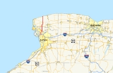
New York State Route 425 (NY 425) is a 23.85 miles (38.38 km) New York state highway that runs from NY 18
in Wilson, New York
on the shore of Lake Ontario
to a connection with Interstate 290
in the Town of Tonawanda
. Between North Tonawanda
and Tonawanda it is known as the Twin Cities Memorial Highway.
 Route 425 has two distinct sections, the Twin Cities Highway section in the Tonawandas, short but heavily trafficked; and the more lightly used two-lane stretch through most of Niagara County
. Niagara Falls Boulevard (U.S. Route 62) makes a rough divider between the two sections.
where Colvin Boulevard crosses the Youngmann Expressway (Interstate 290
). It immediately becomes a divided four-lane highway with exits as it crosses the eastern half of the city of Tonawanda
, running due north. Once past Tonawanda Creek
and into North Tonawanda
, there are traffic light
s and at-grade intersections.
At Wheatfield Street, 425 forks to the northeast and becomes two-lane Erie Avenue, which is maintained by the City of North Tonawanda, still passing very well-developed terrain all the way to Niagara Falls Boulevard.
, as it continues through the open fields of central Niagara County. Traffic in the Wheatfield section has increased due to urban sprawl
, as suburbs are developing northward. The only major highway junction is at NY 31
. North of there, it descends the Niagara Escarpment
, then briefly follows the east–west Lower Mountain Road to get to its final route north along Cambria
-Wilson Road.
This crosses both NY 104
and NY 93
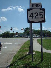
in close succession, near the western end of their concurrency. A few miles beyond, it finally reaches Wilson and becomes Lake Street before ending at NY 18
near the shores of Lake Ontario
.
and the intersection of Cambria–Wilson Road and Lower Mountain Road in Cambria
was designated as part of Route 20, an unsigned legislative route
, by the New York State Legislature on March 1, 1921. When the first set of posted routes in New York
were assigned in 1924, all of legislative Route 20 west of Rochester
became part of NY 3
, a cross-state route that began in North Tonawanda and ended in Plattsburgh
. In the 1930 renumbering of state highways in New York, NY 3 was realigned to follow what is now NY 31
to Niagara Falls
. The former routing of NY 3 between North Tonawanda and Cambria
became part of NY 425, a new route that continued north to NY 18
in Wilson
by way of Cambria–Wilson Road and an overlap with NY 3.
Initially, NY 425 overlapped NY 93
between North Ridge and Lower Mountain Roads. Ca. 1932, NY 3 was realigned in the towns of Cambria and Lockport
to follow Saunders Settlement Road (now NY 31) between NY 425 and the city of Lockport
. Its former routing to the north became NY 3A even though the entirety of the alignment was already part of either NY 425 or NY 93. The NY 3A designation was eliminated ca. 1935 when NY 3 was truncated eastward to a new western terminus in central New York
. The overlap with NY 93 was eliminated in the early 1940s after that route was realigned onto North Ridge Road, U.S. Route 104, and Junction Road between NY 425 and Upper Mountain Road. NY 425 was extended southward into North Tonawanda by 1947, following Erie Avenue and Wheatfield Street to a new terminus at NY 429
(Oliver Street) in downtown.
In the mid-1960s, construction began on a new divided highway
connecting NY 425 in North Tonawanda to Interstate 290
in Tonawanda
. The highway, known as the Twin Cities Memorial Highway, was initially designated as NY 950H, an unsigned reference route, upon opening in the early 1970s. It became part of a rerouted NY 425 between 1970 and 1977. When first built, the Twin Cities Memorial Highway was planned to continue as a divided highway north through North Tonawanda and Wheatfield
to connect with the LaSalle Expressway
in Niagara Falls
via the Belt Expressway. Although the connection was never built, evidence of the initial plans are visible at the respective termini of each highway. The Twin Cities Expressway, along with the LaSalle Expressway and the Milestrip Expressway
were intended to be part of an "outer loop" similar to the one in Rochester linking Buffalo's outer suburbs, but it was never completed due to lack of funding.
New York State Route 18
New York State Route 18 is an east–west state highway in western New York in the United States. It runs parallel to the south shore of Lake Ontario for most of its length between Niagara County and Monroe County...
in Wilson, New York
Wilson, New York
Wilson is a village in Niagara County, New York, United States. The population was 1,213 at the 2000 census. The village is said to be named after Luther Wilson. It is part of the Buffalo–Niagara Falls Metropolitan Statistical Area....
on the shore of Lake Ontario
Lake Ontario
Lake Ontario is one of the five Great Lakes of North America. It is bounded on the north and southwest by the Canadian province of Ontario, and on the south by the American state of New York. Ontario, Canada's most populous province, was named for the lake. In the Wyandot language, ontarío means...
to a connection with Interstate 290
Interstate 290 (New York)
Interstate 290 runs for near Buffalo, New York from I-90 to I-190. It connects Buffalo with its northern suburbs of Amherst and Tonawanda, and provides a route to Niagara Falls that bypasses the city of Buffalo. I-290 also connects to Interstate 990, and through this connection,...
in the Town of Tonawanda
Tonawanda (town), New York
Tonawanda is a town in Erie County, New York, United States. As of the 2000 census, the town had a population of 78,155. The town is at the north border of the county and is the northern suburb of Buffalo...
. Between North Tonawanda
North Tonawanda, New York
North Tonawanda is a city in Niagara County, New York, United States. The population was 31,568 at the 2000 census. It is part of the Buffalo–Niagara Falls Metropolitan Statistical Area. The city is named after Tonawanda Creek, its south border...
and Tonawanda it is known as the Twin Cities Memorial Highway.
Route description
Niagara County, New York
Niagara County is a county located in the U.S. state of New York. As of the 2010 census, the population was 216,469. The county seat is Lockport. The county name is from the Iroquois word Onguiaahra; meaning the strait or thunder of waters. It is the location of Niagara Falls and Fort Niagara, and...
. Niagara Falls Boulevard (U.S. Route 62) makes a rough divider between the two sections.
Tonawandas
NY 425 begins in the town of TonawandaTonawanda (town), New York
Tonawanda is a town in Erie County, New York, United States. As of the 2000 census, the town had a population of 78,155. The town is at the north border of the county and is the northern suburb of Buffalo...
where Colvin Boulevard crosses the Youngmann Expressway (Interstate 290
Interstate 290 (New York)
Interstate 290 runs for near Buffalo, New York from I-90 to I-190. It connects Buffalo with its northern suburbs of Amherst and Tonawanda, and provides a route to Niagara Falls that bypasses the city of Buffalo. I-290 also connects to Interstate 990, and through this connection,...
). It immediately becomes a divided four-lane highway with exits as it crosses the eastern half of the city of Tonawanda
Tonawanda (city), New York
Tonawanda is a city in Erie County, New York, United States. The population was 16,136 at the 2000 census. It is located at the northern edge of Erie County, south across the Erie Canal from North Tonawanda, and north of Buffalo, New York...
, running due north. Once past Tonawanda Creek
Tonawanda Creek
Tonawanda Creek is a small river in Western New York, in the United States. William Bright says the best that can be said of the name is that it is "probably from an Iroquoian source, but of unclear derivation".-Description:...
and into North Tonawanda
North Tonawanda, New York
North Tonawanda is a city in Niagara County, New York, United States. The population was 31,568 at the 2000 census. It is part of the Buffalo–Niagara Falls Metropolitan Statistical Area. The city is named after Tonawanda Creek, its south border...
, there are traffic light
Traffic light
Traffic lights, which may also be known as stoplights, traffic lamps, traffic signals, signal lights, robots or semaphore, are signalling devices positioned at road intersections, pedestrian crossings and other locations to control competing flows of traffic...
s and at-grade intersections.
At Wheatfield Street, 425 forks to the northeast and becomes two-lane Erie Avenue, which is maintained by the City of North Tonawanda, still passing very well-developed terrain all the way to Niagara Falls Boulevard.
North to Wilson
As Shawnee Road, 425 returns to its northerly course, passing one major community, WheatfieldWheatfield, New York
Wheatfield is a town in Niagara County, New York, United States. The population was 18,117 at the 2010 census. The name stems from the agricultural use of the town lands: Growing Wheat....
, as it continues through the open fields of central Niagara County. Traffic in the Wheatfield section has increased due to urban sprawl
Urban sprawl
Urban sprawl, also known as suburban sprawl, is a multifaceted concept, which includes the spreading outwards of a city and its suburbs to its outskirts to low-density and auto-dependent development on rural land, high segregation of uses Urban sprawl, also known as suburban sprawl, is a...
, as suburbs are developing northward. The only major highway junction is at NY 31
New York State Route 31
New York State Route 31 is a state highway that extends for across western and central New York in the United States. The western terminus of the route is at an intersection with NY 104 in the city of Niagara Falls. Its eastern terminus is at a traffic circle with NY 26 in Vernon...
. North of there, it descends the Niagara Escarpment
Niagara Escarpment
The Niagara Escarpment is a long escarpment, or cuesta, in the United States and Canada that runs westward from New York State, through Ontario, Michigan, Wisconsin and Illinois...
, then briefly follows the east–west Lower Mountain Road to get to its final route north along Cambria
Cambria, New York
Cambria is a town in Niagara County, New York, USA. The population was 5,839 at the 2010 census. Cambria is an early name for Wales.The Town of Cambria is in the center of Niagara County.New York State Route 93 passes through the town.- History :...
-Wilson Road.
This crosses both NY 104
New York State Route 104
New York State Route 104 is a long east–west state highway in Upstate New York, United States. It spans six counties and enters the vicinity of four cities—Niagara Falls, Lockport, Rochester, and Oswego—as it follows a routing largely parallel to that of the southern shoreline of Lake...
and NY 93
New York State Route 93
New York State Route 93 is a state highway in western New York in the United States. It runs in a northwest–southeast direction between NY 18F near the Niagara River in the village of Youngstown and NY 5 just south of the village of Akron...
in close succession, near the western end of their concurrency. A few miles beyond, it finally reaches Wilson and becomes Lake Street before ending at NY 18
New York State Route 18
New York State Route 18 is an east–west state highway in western New York in the United States. It runs parallel to the south shore of Lake Ontario for most of its length between Niagara County and Monroe County...
near the shores of Lake Ontario
Lake Ontario
Lake Ontario is one of the five Great Lakes of North America. It is bounded on the north and southwest by the Canadian province of Ontario, and on the south by the American state of New York. Ontario, Canada's most populous province, was named for the lake. In the Wyandot language, ontarío means...
.
History
The portion of modern NY 425 between U.S. Route 62 in North TonawandaNorth Tonawanda, New York
North Tonawanda is a city in Niagara County, New York, United States. The population was 31,568 at the 2000 census. It is part of the Buffalo–Niagara Falls Metropolitan Statistical Area. The city is named after Tonawanda Creek, its south border...
and the intersection of Cambria–Wilson Road and Lower Mountain Road in Cambria
Cambria, New York
Cambria is a town in Niagara County, New York, USA. The population was 5,839 at the 2010 census. Cambria is an early name for Wales.The Town of Cambria is in the center of Niagara County.New York State Route 93 passes through the town.- History :...
was designated as part of Route 20, an unsigned legislative route
Legislative route
In United States, a legislative route or legislative highway is a highway defined by laws passed in a state legislature. The numbering of such highways may or may not correspond to the numbers familiar to the public as part of the state, U.S. highway, and Interstate highway systems...
, by the New York State Legislature on March 1, 1921. When the first set of posted routes in New York
New York
New York is a state in the Northeastern region of the United States. It is the nation's third most populous state. New York is bordered by New Jersey and Pennsylvania to the south, and by Connecticut, Massachusetts and Vermont to the east...
were assigned in 1924, all of legislative Route 20 west of Rochester
Rochester, New York
Rochester is a city in Monroe County, New York, south of Lake Ontario in the United States. Known as The World's Image Centre, it was also once known as The Flour City, and more recently as The Flower City...
became part of NY 3
New York State Route 3
New York State Route 3 is a major east–west state highway in New York, United States, that connects central New York to the North Country region near the Canadian border via Adirondack Park. The route extends for between its western terminus at an intersection with NY 104A in the Cayuga...
, a cross-state route that began in North Tonawanda and ended in Plattsburgh
Plattsburgh (city), New York
Plattsburgh is a city in and county seat of Clinton County, New York, United States. The population was 19,989 at the 2010 census. The population of the unincorporated areas within the Town of Plattsburgh was 11,870 as of the 2010 census; making the population for the immediate, urban Plattsburgh,...
. In the 1930 renumbering of state highways in New York, NY 3 was realigned to follow what is now NY 31
New York State Route 31
New York State Route 31 is a state highway that extends for across western and central New York in the United States. The western terminus of the route is at an intersection with NY 104 in the city of Niagara Falls. Its eastern terminus is at a traffic circle with NY 26 in Vernon...
to Niagara Falls
Niagara Falls, New York
Niagara Falls is a city in Niagara County, New York, United States. As of the 2010 census, the city had a total population of 50,193, down from the 55,593 recorded in the 2000 census. It is across the Niagara River from Niagara Falls, Ontario , both named after the famed Niagara Falls which they...
. The former routing of NY 3 between North Tonawanda and Cambria
Cambria, New York
Cambria is a town in Niagara County, New York, USA. The population was 5,839 at the 2010 census. Cambria is an early name for Wales.The Town of Cambria is in the center of Niagara County.New York State Route 93 passes through the town.- History :...
became part of NY 425, a new route that continued north to NY 18
New York State Route 18
New York State Route 18 is an east–west state highway in western New York in the United States. It runs parallel to the south shore of Lake Ontario for most of its length between Niagara County and Monroe County...
in Wilson
Wilson, New York
Wilson is a village in Niagara County, New York, United States. The population was 1,213 at the 2000 census. The village is said to be named after Luther Wilson. It is part of the Buffalo–Niagara Falls Metropolitan Statistical Area....
by way of Cambria–Wilson Road and an overlap with NY 3.
Initially, NY 425 overlapped NY 93
New York State Route 93
New York State Route 93 is a state highway in western New York in the United States. It runs in a northwest–southeast direction between NY 18F near the Niagara River in the village of Youngstown and NY 5 just south of the village of Akron...
between North Ridge and Lower Mountain Roads. Ca. 1932, NY 3 was realigned in the towns of Cambria and Lockport
Lockport (town), New York
Lockport is a town in Niagara County, New York, United States. The population was 20,529 at the 2010 census. The name is derived from the series of canal locks on the Erie Canal...
to follow Saunders Settlement Road (now NY 31) between NY 425 and the city of Lockport
Lockport (city), New York
Lockport is a city in Niagara County, New York, United States. The population was 21,165 at the 2010 census. The name is derived from a set of Erie canal locks within the city. Lockport is the county seat of Niagara County and is surrounded by the town of Lockport...
. Its former routing to the north became NY 3A even though the entirety of the alignment was already part of either NY 425 or NY 93. The NY 3A designation was eliminated ca. 1935 when NY 3 was truncated eastward to a new western terminus in central New York
Central New York
Central New York is a term used to broadly describe the central region of New York State, roughly including the following counties and cities:...
. The overlap with NY 93 was eliminated in the early 1940s after that route was realigned onto North Ridge Road, U.S. Route 104, and Junction Road between NY 425 and Upper Mountain Road. NY 425 was extended southward into North Tonawanda by 1947, following Erie Avenue and Wheatfield Street to a new terminus at NY 429
New York State Route 429
New York State Route 429 is a north–south state highway located entirely within Niagara County, New York, in the United States. It extends for from an intersection with NY 265 and NY 384 in North Tonawanda to a junction with NY 104 on the border between the towns of Cambria...
(Oliver Street) in downtown.
In the mid-1960s, construction began on a new divided highway
Divided Highway
Divided Highway is a compilation album by American rock band The Doobie Brothers, released in 2003. . All tracks are taken from the albums Cycles and Brotherhood .-Track listing:...
connecting NY 425 in North Tonawanda to Interstate 290
Interstate 290 (New York)
Interstate 290 runs for near Buffalo, New York from I-90 to I-190. It connects Buffalo with its northern suburbs of Amherst and Tonawanda, and provides a route to Niagara Falls that bypasses the city of Buffalo. I-290 also connects to Interstate 990, and through this connection,...
in Tonawanda
Tonawanda (city), New York
Tonawanda is a city in Erie County, New York, United States. The population was 16,136 at the 2000 census. It is located at the northern edge of Erie County, south across the Erie Canal from North Tonawanda, and north of Buffalo, New York...
. The highway, known as the Twin Cities Memorial Highway, was initially designated as NY 950H, an unsigned reference route, upon opening in the early 1970s. It became part of a rerouted NY 425 between 1970 and 1977. When first built, the Twin Cities Memorial Highway was planned to continue as a divided highway north through North Tonawanda and Wheatfield
Wheatfield, New York
Wheatfield is a town in Niagara County, New York, United States. The population was 18,117 at the 2010 census. The name stems from the agricultural use of the town lands: Growing Wheat....
to connect with the LaSalle Expressway
LaSalle Expressway
The LaSalle Expressway is a long limited-access highway in Niagara County, New York, United States. It begins near the North Grand Island Bridge at an interchange with Interstate 190 in Niagara Falls and ends just south of the Niagara Falls International Airport at Williams Road in Wheatfield...
in Niagara Falls
Niagara Falls, New York
Niagara Falls is a city in Niagara County, New York, United States. As of the 2010 census, the city had a total population of 50,193, down from the 55,593 recorded in the 2000 census. It is across the Niagara River from Niagara Falls, Ontario , both named after the famed Niagara Falls which they...
via the Belt Expressway. Although the connection was never built, evidence of the initial plans are visible at the respective termini of each highway. The Twin Cities Expressway, along with the LaSalle Expressway and the Milestrip Expressway
New York State Route 179
New York State Route 179 is a short state highway located south of Buffalo in Erie County, New York, in the United States. It is a four-lane divided road for most of its length. It is known as Mile Strip Road. A small section between U.S...
were intended to be part of an "outer loop" similar to the one in Rochester linking Buffalo's outer suburbs, but it was never completed due to lack of funding.