
New York State Route 15
Encyclopedia
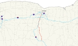
New York State Route 15 (NY 15) is a north–south state highway
located in western New York
in the United States. The southern terminus of the route is officially at Interstate 390 (I-390) exit 3 south of the village of Wayland
, although some signage indicating that NY 15 continues south to the northern terminus of U.S. Route 15
(US 15) in Painted Post
still exists. The northern terminus of NY 15 is at an intersection with NY 31
in downtown Rochester
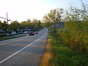
. Outside of Monroe County
, NY 15 is a rural two-lane highway. In the Rochester suburbs of Henrietta
and Brighton
, however, NY 15 is a major commercial strip, and the section in Rochester is a two-to-four lane street that serves commercial and residential areas.
From Lakeville north to the Rochester city limits, NY 15 is little more than an alternate route to I-390, which closely follows the route through northern Livingston County
and southern Monroe County. South of Lakeville, the route is a regionally important highway that serves the villages of Livonia
and Wayland
and the hamlets of Conesus
and Springwater
. It crosses US 20
near Avon
and overlaps with US 20A
between Livonia and Lakeville. NY 15A
, an easterly alternate route of NY 15, parallels its parent from Springwater north to Rochester.
All of NY 15 was originally part of US 15. In 1974, US 15 was truncated to Painted Post and its continuation to Rochester was designated NY 15. For some time afterward, NY 15 was signed as a direct continuation of US 15; that is, it began in Painted Post and had overlaps with NY 17
and I-390 to Wayland. Officially, however, the route began overlapped with NY 21
south of Wayland, and in 2009 the New York State Department of Transportation
(NYSDOT) made plans to remove all signage for NY 15 on I-86
and I-390.
is locally maintained.
exit 3 in the town of Wayland
in northwestern Steuben County
. It heads north along an overlap with NY 21
, connecting to NY 415
and passing the northwest end of the B&H Rail Corporation's main line on its way into the village of Wayland
, where it becomes South Lackawanna Street. In the village center, NY 21 separates from NY 15, turning east at Naples Street at an intersection that also serves as the southern terminus of NY 63
. The route continues north alone, becoming North Lackawanna Street for its last few blocks in the village before leaving it for Livingston County
. Across the county line in the town of Springwater
, NY 15 proceeds through more open areas as it heads generally northward into a valley containing the hamlet of Springwater, built up around NY 15's junction with NY 15A
.
 While NY 15A heads due north from Springwater toward Hemlock Lake
, NY 15 leaves Springwater to the west, climbing out of the valley and snaking its way northwestward through the hills of the Southern Tier
to the town of Conesus
. At the hamlet of Conesus, NY 15 connects to County Route 71 (CR 71), formerly designated as NY 255
. Past Conesus, the route continues northward across rolling, rural terrain to the village of Livonia
. NY 15 veers northeastward as Commercial Street for three blocks to Main Street, which carries the east–west US 20A
through the village. Here, NY 15 turns west onto Main Street, joining US 20A on a 2.5 miles (4 km) overlap along Main Street and Big Tree Road that takes both routes into the adjacent hamlet of Lakeville, located at the northern tip of Conesus Lake
. The two routes split in the center of the community, where US 20A continues west towards Buffalo while NY 15 turns north towards Rochester
.
The route heads away from Lakeville on a northwesterly alignment, paralleling Conesus Creek and to a lesser extent the Livonia, Avon and Lakeville Railroad
(LAL) to a junction with NY 256
on the Livonia–Geneseo town line. NY 256 merges into NY 15 here, and NY 15 takes on its linear north-northeasterly routing as it heads into the adjacent town of Avon
. Just north of the town line, NY 15 passes under the LAL and comes into contact with I-390 once again, this time at exit 9. Past the exit, I-390 turns to the north, following NY 15 as both routes cross 2 miles (3.2 km) of open, sparsely developed areas on their way to the hamlet of East Avon, centered around NY 15's junction with US 20
and NY 5
. Outside of East Avon, the two highways continue to follow parallel alignments for another 2 miles (3.2 km) to the Monroe County
line.
, NY 15 takes on the name West Henrietta Road, which it keeps until the Rochester city line 12 miles (19 km) to the north. The route remains close to I-390 throughout most of southern Monroe County, crossing over the expressway and Honeoye Creek
before connecting to I-390 at exit 11, an exit serving both NY 15 and NY 251
, which intersect a short distance east of the interchange. Not far from the exit is the Henrietta
town line, at which point the route begins to pass through gradually more developed areas as it enters the outer suburbs of Rochester. In West Henrietta, the last hamlet of consequence along the highway, NY 15 crosses Erie Station Road, formerly part of NY 253
. Just north of the community is a junction with Thruway Park Drive, the current routing of NY 253 through the area.
Here, NY 15 takes part in its third and final concurrency as NY 253 joins NY 15 for one mile (1.6 km) across the New York State Thruway
(I-90
) to Lehigh Station Road, which NY 253 follows eastward toward Pittsford
. NY 15, meanwhile, continues on a northeasterly line toward Rochester, passing by the studios of local television station WHAM
prior to entering a major commercial district surrounding The Marketplace Mall
and Jefferson Road (NY 252
). Within the district, NY 15 crosses a spur of the LAL and intersects NY 252 at a grade-separated interchange just south of the Henrietta–Brighton
town line. The route exits Henrietta for Brighton, but the commercial surroundings remain until Crittenden Road, a local east–west arterial linking NY 15 to both NY 15A and the Monroe Community College
campus on the latter route.
. At the northern edge of the area, NY 15 meets and crosses I-390 for the final time at exit 16. While I-390 continues northwest from here, bypassing most of Rochester, NY 15 stays true to its linear northeasterly alignment, crossing the Erie Canal and entering the city's southernmost section. In this area, NY 15, now Mount Hope Avenue, serves the Monroe County offices and meets NY 15A at East Henrietta Road, completing the eastern alternate loop of NY 15. One long block to the north is Elmwood Avenue (formerly NY 47
), which crosses NY 15 at the southeastern corner of Mount Hope Cemetery
.
The route continues on, running along the east side of the cemetery and the west side of Highland Park as it crosses into a predominately residential section of Rochester known as the South Wedge. NY 15 finally breaks from the linear alignment it had followed since southern Henrietta and gradually gets closer to the nearby Genesee River
as it heads northward through the neighborhood; however, it makes a sharp turn to the east just south of downtown Rochester
to meet South Avenue in the shadow of I-490
and the Inner Loop
. Mount Hope Avenue ends here while NY 15 continues east onto Byron Street, a one-block connector between South and South Clinton Avenues. At its east end, NY 15 turns north onto a unidirectional section of Clinton Avenue, passing over I-490 and the Inner Loop before reaching its northern terminus at the intersection of South Clinton Avenue and Woodbury Boulevard (NY 31
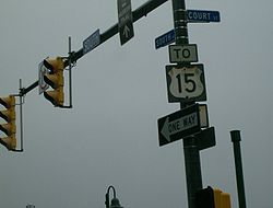
) in downtown Rochester.
Most of southeastern downtown Rochester's major streets are one-way, resulting in split routings for both NY 15 and NY 31 as they pass through downtown. Westbound NY 31 continues north from the north end of NY 15 on South Clinton Avenue to East Broad Street, onto which it turns west. Southbound NY 15, meanwhile, begins one block to the west at the intersection of South Avenue and Woodbury Boulevard (where eastbound NY 31 makes a left turn). NY 15 follows South Avenue, as well as a number of ramps traversing the Inner Loop and I-490, to the intersection of Mount Hope Avenue and Byron Street, where it joins northbound NY 15 on Mount Hope Avenue.
 The highway connecting Lawrenceville, Pennsylvania
, to Rochester
by way of Springwater
and Avon
was originally designated as NY 4 when the first set of posted routes in New York were assigned in 1924. NY 4 was renumbered to NY 2 in 1927 to avoid numerical duplication with the new US 4
in the Glens Falls
area. At the Pennsylvania state line, NY 2 connected to US 111
. US 111 was replaced by an extended US 15
ca. 1938. US 15 was extended northward to Rochester by the following year, supplanting NY 2.
Construction began in the 1960s on the portion of the Southern Tier Expressway in Steuben County
. The section from Painted Post
to Campbell
opened in the mid-1960s as a realignment of US 15. The former surface routing of US 15 was redesignated as NY 415
. An extension of the expressway to Savona
was completed by 1971, and the entirety of the highway through Steuben County was completed ca. 1973. US 15 left the expressway at exit 38 in Bath
to rejoin its original alignment.
In 1974, US 15 was truncated southward to Painted Post and the portion of its former routing north of Painted Post was redesignated as NY 15. Around the same time, NY 17
was realigned between Olean
and Corning
to use the Southern Tier Expressway instead of modern NY 417
. The portion of the Genesee Expressway (I-390
) from Avoca
to Wayland opened to traffic in the mid-1970s. Although signage for NY 15 existed on NY 17 and I-390, no such overlap existed in reality as the southern terminus of NY 15 was defined as I-390 in Wayland by the New York State Department of Transportation
(NYSDOT) as early as 1977. In 2009, NYSDOT elected to remove the NY 15 signage along the Southern Tier Expressway and I-390, effectively moving the signed terminus to I-390 in Wayland as well.
 NY 15A
(35.19 miles or 56.63 km) is an alternate route of NY 15 between Springwater
and Rochester
via Lima
. It was originally designated as NY 2A in the 1930 renumbering of state highways in New York before becoming NY 15A ca. 1939.
State highway
State highway, state road or state route can refer to one of three related concepts, two of them related to a state or provincial government in a country that is divided into states or provinces :#A...
located in western New York
Western New York
Western New York is the westernmost region of the state of New York. It includes the cities of Buffalo, Rochester, Niagara Falls, the surrounding suburbs, as well as the outlying rural areas of the Great Lakes lowlands, the Genesee Valley, and the Southern Tier. Some historians, scholars and others...
in the United States. The southern terminus of the route is officially at Interstate 390 (I-390) exit 3 south of the village of Wayland
Wayland (village), New York
Wayland is a village in Steuben County, New York, United States. The population was 1,893 at the 2000 census.The Village of Wayland is in north part of the Town of Wayland, near the north border of Steuben County.- History :...
, although some signage indicating that NY 15 continues south to the northern terminus of U.S. Route 15
U.S. Route 15 in New York
U.S. Route 15 is a part of the U.S. Highway System that runs from Walterboro, South Carolina, to Painted Post, New York. In the U.S. state of New York, US 15 extends through the Southern Tier from the Pennsylvania state line at Lindley north to an interchange with the Southern Tier...
(US 15) in Painted Post
Painted Post, New York
Painted Post is a village in Steuben County, New York, United States. The village is in the town of Erwin, west of the city of Corning. The population was 1,842 at the 2000 census. The name comes from a painted and carved post found by explorers at the junction of three local rivers...
still exists. The northern terminus of NY 15 is at an intersection with NY 31
New York State Route 31
New York State Route 31 is a state highway that extends for across western and central New York in the United States. The western terminus of the route is at an intersection with NY 104 in the city of Niagara Falls. Its eastern terminus is at a traffic circle with NY 26 in Vernon...
in downtown Rochester
Rochester, New York
Rochester is a city in Monroe County, New York, south of Lake Ontario in the United States. Known as The World's Image Centre, it was also once known as The Flour City, and more recently as The Flower City...
. Outside of Monroe County
Monroe County, New York
Monroe County is a county located in the U.S. state of New York. As of the 2010 census, the population was 744,344. It is named after James Monroe, fifth President of the United States of America. Its county seat is the city of Rochester....
, NY 15 is a rural two-lane highway. In the Rochester suburbs of Henrietta
Henrietta, New York
Henrietta is a town in Monroe County, New York, United States. It is a suburb of Rochester. The population was 42,581 at the 2010 census. Established in 1818, the town is named after Henrietta Laura Pulteney, Countess of Bath, daughter of Sir William Pulteney, 5th Baronet, a major British...
and Brighton
Brighton, Monroe County, New York
Brighton is a town in Monroe County, New York, USA. The population was 36,609 at the 2010 census.-History:The Town of Brighton, located on the southeast border of the city of Rochester, was originally settled approximately 1790, and formally established in 1814—earning it recognition as one...
, however, NY 15 is a major commercial strip, and the section in Rochester is a two-to-four lane street that serves commercial and residential areas.
From Lakeville north to the Rochester city limits, NY 15 is little more than an alternate route to I-390, which closely follows the route through northern Livingston County
Livingston County, New York
As of the census of 2000, there were 64,328 people, 22,150 households, and 15,349 families residing in the county. The population density was 102 people per square mile . There were 24,023 housing units at an average density of 38 per square mile...
and southern Monroe County. South of Lakeville, the route is a regionally important highway that serves the villages of Livonia
Livonia (village), New York
Livonia is a village located in the Town of Livonia, Livingston County, New York, at the intersection of US Route 20 and Route 15. The population was 1,373 at the 2000 census.-Geography:Livonia is located at ....
and Wayland
Wayland (village), New York
Wayland is a village in Steuben County, New York, United States. The population was 1,893 at the 2000 census.The Village of Wayland is in north part of the Town of Wayland, near the north border of Steuben County.- History :...
and the hamlets of Conesus
Conesus, New York
Conesus is a town in Livingston County, New York , United States. The population was 2,353 at the 2000 census. The name is derived from a native word meaning "Berry place."...
and Springwater
Springwater, New York
Springwater is a town in Livingston County, New York, United States. The population was 2,322 at the 2000 census.The Town of Springwater is in the southeast part of the county.-History:The first settlers arrived around 1807...
. It crosses US 20
U.S. Route 20 in New York
U.S. Route 20 is a part of the U.S. Highway System that runs from Newport, Oregon, to Boston, Massachusetts. In the U.S. state of New York, US 20 extends from the Pennsylvania state line at Ripley to the Massachusetts state line in the Berkshire Mountains. US 20 is the longest...
near Avon
Avon (village), New York
Avon is a village in Livingston County, New York, USA. The population was 2,977 at the 2000 census. The village is named after the River Avon. ....
and overlaps with US 20A
U.S. Route 20A (New York)
U.S. Route 20A is an east–west alternate route of US 20 that extends for across the western portion of New York in the United States. It leaves US 20 in Hamburg, a suburb of Buffalo, and rejoins it in East Bloomfield about five miles west of Canandaigua, the county seat of...
between Livonia and Lakeville. NY 15A
New York State Route 15A
New York State Route 15A is a north–south state highway located in the western portion of New York in the United States. It serves as an easterly alternate route of NY 15, beginning in the Livingston County town of Springwater and ending to the north in the Monroe County city of...
, an easterly alternate route of NY 15, parallels its parent from Springwater north to Rochester.
All of NY 15 was originally part of US 15. In 1974, US 15 was truncated to Painted Post and its continuation to Rochester was designated NY 15. For some time afterward, NY 15 was signed as a direct continuation of US 15; that is, it began in Painted Post and had overlaps with NY 17
New York State Route 17
New York State Route 17 is a state highway that extends for through the Southern Tier and Downstate regions of New York in the United States...
and I-390 to Wayland. Officially, however, the route began overlapped with NY 21
New York State Route 21
New York State Route 21 is a state highway extending for through the western part of New York in the United States. The southern terminus of the route is at NY 417 in Andover. The northern terminus is at NY 104 in Williamson...
south of Wayland, and in 2009 the New York State Department of Transportation
New York State Department of Transportation
The New York State Department of Transportation is responsible for the development and operation of highways, railroads, mass transit systems, ports, waterways and aviation facilities in the U.S...
(NYSDOT) made plans to remove all signage for NY 15 on I-86
Interstate 86 (east)
Interstate 86 is an Interstate Highway that extends for through northwestern Pennsylvania and southern New York in the United States...
and I-390.
Route description
Most of NY 15 is maintained by NYSDOT; however, the section of the route that lies within the city of RochesterRochester, New York
Rochester is a city in Monroe County, New York, south of Lake Ontario in the United States. Known as The World's Image Centre, it was also once known as The Flour City, and more recently as The Flower City...
is locally maintained.
Steuben and Livingston Counties
NY 15 begins at I-390Interstate 390
Interstate 390 is a north–south auxiliary Interstate Highway located entirely within New York in the United States. The southern terminus of the route is at the Southern Tier Expressway in the town of Avoca. Its northern terminus is at I-490 in Rochester...
exit 3 in the town of Wayland
Wayland (town), New York
Wayland is a town in Steuben County, New York, United States. The population was 4,314 at the 2000 census.The Town of Wayland contains a village Wayland. The town is in the northern part of the county, northwest of Bath, New York.- History :...
in northwestern Steuben County
Steuben County, New York
Steuben County is a county located in the U.S. state of New York. As of the 2010 census, the population was 98,990. Its name is in honor of Baron von Steuben, a German general who fought on the American side in the American Revolutionary War, though it is not pronounced the same...
. It heads north along an overlap with NY 21
New York State Route 21
New York State Route 21 is a state highway extending for through the western part of New York in the United States. The southern terminus of the route is at NY 417 in Andover. The northern terminus is at NY 104 in Williamson...
, connecting to NY 415
New York State Route 415
New York State Route 415 is a state highway located in Steuben County, New York, United States. It is a north–south trunk road that parallels in part, the Cohocton River, Interstate 86 and Interstate 390. The southern terminus of the route is at an intersection with NY 414 in...
and passing the northwest end of the B&H Rail Corporation's main line on its way into the village of Wayland
Wayland (village), New York
Wayland is a village in Steuben County, New York, United States. The population was 1,893 at the 2000 census.The Village of Wayland is in north part of the Town of Wayland, near the north border of Steuben County.- History :...
, where it becomes South Lackawanna Street. In the village center, NY 21 separates from NY 15, turning east at Naples Street at an intersection that also serves as the southern terminus of NY 63
New York State Route 63
New York State Route 63 is a state highway in the western part of New York in the United States. The southern terminus of the route is at an intersection with NY 15 and NY 21 in the village of Wayland in Steuben County. Its northern end is at a junction with NY 18 in the town...
. The route continues north alone, becoming North Lackawanna Street for its last few blocks in the village before leaving it for Livingston County
Livingston County, New York
As of the census of 2000, there were 64,328 people, 22,150 households, and 15,349 families residing in the county. The population density was 102 people per square mile . There were 24,023 housing units at an average density of 38 per square mile...
. Across the county line in the town of Springwater
Springwater, New York
Springwater is a town in Livingston County, New York, United States. The population was 2,322 at the 2000 census.The Town of Springwater is in the southeast part of the county.-History:The first settlers arrived around 1807...
, NY 15 proceeds through more open areas as it heads generally northward into a valley containing the hamlet of Springwater, built up around NY 15's junction with NY 15A
New York State Route 15A
New York State Route 15A is a north–south state highway located in the western portion of New York in the United States. It serves as an easterly alternate route of NY 15, beginning in the Livingston County town of Springwater and ending to the north in the Monroe County city of...
.
Hemlock Lake
Hemlock Lake is one of the minor Finger Lakes. It is mostly located in Livingston County, New York, south of Rochester, with a portion overlapping into Ontario County....
, NY 15 leaves Springwater to the west, climbing out of the valley and snaking its way northwestward through the hills of the Southern Tier
Southern Tier
The Southern Tier is a geographical term that refers to the counties of New York State west of the Catskill Mountains along the northern border of Pennsylvania. It is a loosely defined term that generally includes the counties that border Pennsylvania west of Delaware County inclusive...
to the town of Conesus
Conesus, New York
Conesus is a town in Livingston County, New York , United States. The population was 2,353 at the 2000 census. The name is derived from a native word meaning "Berry place."...
. At the hamlet of Conesus, NY 15 connects to County Route 71 (CR 71), formerly designated as NY 255
New York State Route 255
New York State Route 255 was a state highway located in Livingston County, New York, in the United States. The southern terminus of the route was at an intersection with NY 256 south of the community of Scottsburg in Sparta. Its northern terminus was at a junction with NY 15 in...
. Past Conesus, the route continues northward across rolling, rural terrain to the village of Livonia
Livonia (village), New York
Livonia is a village located in the Town of Livonia, Livingston County, New York, at the intersection of US Route 20 and Route 15. The population was 1,373 at the 2000 census.-Geography:Livonia is located at ....
. NY 15 veers northeastward as Commercial Street for three blocks to Main Street, which carries the east–west US 20A
U.S. Route 20A (New York)
U.S. Route 20A is an east–west alternate route of US 20 that extends for across the western portion of New York in the United States. It leaves US 20 in Hamburg, a suburb of Buffalo, and rejoins it in East Bloomfield about five miles west of Canandaigua, the county seat of...
through the village. Here, NY 15 turns west onto Main Street, joining US 20A on a 2.5 miles (4 km) overlap along Main Street and Big Tree Road that takes both routes into the adjacent hamlet of Lakeville, located at the northern tip of Conesus Lake
Conesus Lake
Conesus Lake is one of the minor Finger Lakes in western New York. It is western-most of eleven total Finger Lakes. The lake's outlet is in Lakeville, New York a hamlet in the Town of Livonia, New York in Livingston County, south of Rochester, New York. The lake's inlet is in the Town of Conesus,...
. The two routes split in the center of the community, where US 20A continues west towards Buffalo while NY 15 turns north towards Rochester
Rochester, New York
Rochester is a city in Monroe County, New York, south of Lake Ontario in the United States. Known as The World's Image Centre, it was also once known as The Flour City, and more recently as The Flower City...
.
The route heads away from Lakeville on a northwesterly alignment, paralleling Conesus Creek and to a lesser extent the Livonia, Avon and Lakeville Railroad
Livonia, Avon and Lakeville Railroad
The Livonia, Avon and Lakeville Railroad is a short line railroad that operates in Livingston County and Monroe County in New York, United States...
(LAL) to a junction with NY 256
New York State Route 256
New York State Route 256 is a north–south state highway located within Livingston County, New York, in the United States. It extends for across mostly rural terrain from an intersection with NY 63 in the village of Dansville to a junction with NY 15 on the Geneseo–Livonia town line...
on the Livonia–Geneseo town line. NY 256 merges into NY 15 here, and NY 15 takes on its linear north-northeasterly routing as it heads into the adjacent town of Avon
Avon (town), New York
Avon is a town in Livingston County, New York, United States. The town is bordered on the north by the town of Rush, New York in Monroe County. Avon is south of Rochester. The population was 6,443 at the 2000 census. The town is named after the river Avon...
. Just north of the town line, NY 15 passes under the LAL and comes into contact with I-390 once again, this time at exit 9. Past the exit, I-390 turns to the north, following NY 15 as both routes cross 2 miles (3.2 km) of open, sparsely developed areas on their way to the hamlet of East Avon, centered around NY 15's junction with US 20
U.S. Route 20 in New York
U.S. Route 20 is a part of the U.S. Highway System that runs from Newport, Oregon, to Boston, Massachusetts. In the U.S. state of New York, US 20 extends from the Pennsylvania state line at Ripley to the Massachusetts state line in the Berkshire Mountains. US 20 is the longest...
and NY 5
New York State Route 5
New York State Route 5 is a state highway that extends for across the state of New York in the United States. It begins at the Pennsylvania state line in the Chautauqua County town of Ripley and passes through Buffalo, Syracuse, Utica, Schenectady, and several other smaller cities and...
. Outside of East Avon, the two highways continue to follow parallel alignments for another 2 miles (3.2 km) to the Monroe County
Monroe County, New York
Monroe County is a county located in the U.S. state of New York. As of the 2010 census, the population was 744,344. It is named after James Monroe, fifth President of the United States of America. Its county seat is the city of Rochester....
line.
Southern Monroe County
Now in the town of RushRush, New York
Rush is a town in Monroe County, New York, United States. The population was 3,478 at the 2010 census.The Town of Rush is a suburb of Rochester located in the southwest part of the county.-Geography:...
, NY 15 takes on the name West Henrietta Road, which it keeps until the Rochester city line 12 miles (19 km) to the north. The route remains close to I-390 throughout most of southern Monroe County, crossing over the expressway and Honeoye Creek
Honeoye Creek
Honeoye Creek is a tributary of the Genesee River in western New York in the United States.Honeoye Creek emerges from the north end of Honeoye Lake, one of the Finger Lakes, in Richmond, Ontario County...
before connecting to I-390 at exit 11, an exit serving both NY 15 and NY 251
New York State Route 251
New York State Route 251 is an east–west state highway in western New York in the United States. It extends for from NY 383 in Scottsville, Monroe County, to NY 96 in the town of Victor, Ontario County...
, which intersect a short distance east of the interchange. Not far from the exit is the Henrietta
Henrietta, New York
Henrietta is a town in Monroe County, New York, United States. It is a suburb of Rochester. The population was 42,581 at the 2010 census. Established in 1818, the town is named after Henrietta Laura Pulteney, Countess of Bath, daughter of Sir William Pulteney, 5th Baronet, a major British...
town line, at which point the route begins to pass through gradually more developed areas as it enters the outer suburbs of Rochester. In West Henrietta, the last hamlet of consequence along the highway, NY 15 crosses Erie Station Road, formerly part of NY 253
New York State Route 253
New York State Route 253 is a long east–west state highway in Monroe County, New York, United States. The western terminus of the route is at NY 383 in the village of Scottsville. Its eastern terminus is at NY 65 in the town of Pittsford...
. Just north of the community is a junction with Thruway Park Drive, the current routing of NY 253 through the area.
Here, NY 15 takes part in its third and final concurrency as NY 253 joins NY 15 for one mile (1.6 km) across the New York State Thruway
New York State Thruway
The New York State Thruway is a system of limited-access highways located within the state of New York in the United States. The system, known officially as the Governor Thomas E. Dewey Thruway for former New York Governor Thomas E. Dewey, is operated by the New York State Thruway Authority and...
(I-90
Interstate 90 in New York
Interstate 90 is a part of the Interstate Highway System that runs from Seattle, Washington, to Boston, Massachusetts. In the U.S. state of New York, I-90 extends from the Pennsylvania state line at Ripley to the Massachusetts state line at Canaan...
) to Lehigh Station Road, which NY 253 follows eastward toward Pittsford
Pittsford (village), New York
Pittsford is a village in Monroe County, New York, United States. The population was 1,418 at the 2000 census. It is named after Pittsford, Vermont, the native town of a founding father....
. NY 15, meanwhile, continues on a northeasterly line toward Rochester, passing by the studios of local television station WHAM
WHAM-TV
WHAM-TV is the ABC-affiliated television station for Rochester, New York. It broadcasts a high definition digital signal on VHF channel 13 from a transmitter on Pinnacle Hill on the border between Rochester and Brighton. The station can also be seen on Time Warner channel 13 and in high definition...
prior to entering a major commercial district surrounding The Marketplace Mall
The Marketplace Mall
The Marketplace Mall is managed by Wilmorite and located in the heart of the Rochester, New York metropolitan area on Hylan Drive, in the suburb of Henrietta....
and Jefferson Road (NY 252
New York State Route 252
New York State Route 252 is an east–west state highway south of Rochester in Monroe County, New York, in the United States. The western terminus of the route is at an intersection with NY 33A in Chili and the eastern terminus is at a junction with NY 64 and NY 96 in the village...
). Within the district, NY 15 crosses a spur of the LAL and intersects NY 252 at a grade-separated interchange just south of the Henrietta–Brighton
Brighton, Monroe County, New York
Brighton is a town in Monroe County, New York, USA. The population was 36,609 at the 2010 census.-History:The Town of Brighton, located on the southeast border of the city of Rochester, was originally settled approximately 1790, and formally established in 1814—earning it recognition as one...
town line. The route exits Henrietta for Brighton, but the commercial surroundings remain until Crittenden Road, a local east–west arterial linking NY 15 to both NY 15A and the Monroe Community College
Monroe Community College
Monroe Community College is a two-year college of the State University of New York, located in Monroe County, New York. The college has two campuses, one in the town of Brighton and another, the Damon City Campus, in the City of Rochester...
campus on the latter route.
Rochester
North of Crittenden Road, NY 15 passes through a pocket of residential development that borders I-390 and the adjacent Erie CanalErie Canal
The Erie Canal is a waterway in New York that runs about from Albany, New York, on the Hudson River to Buffalo, New York, at Lake Erie, completing a navigable water route from the Atlantic Ocean to the Great Lakes. The canal contains 36 locks and encompasses a total elevation differential of...
. At the northern edge of the area, NY 15 meets and crosses I-390 for the final time at exit 16. While I-390 continues northwest from here, bypassing most of Rochester, NY 15 stays true to its linear northeasterly alignment, crossing the Erie Canal and entering the city's southernmost section. In this area, NY 15, now Mount Hope Avenue, serves the Monroe County offices and meets NY 15A at East Henrietta Road, completing the eastern alternate loop of NY 15. One long block to the north is Elmwood Avenue (formerly NY 47
New York State Route 47
New York State Route 47 was a long state highway around Rochester in New York, United States. It formed a semicircle through the inner suburbs of Rochester, following expressways west and east of the city and surface streets south of Rochester. The western terminus of the route was at an...
), which crosses NY 15 at the southeastern corner of Mount Hope Cemetery
Mount Hope Cemetery, Rochester
Mount Hope Cemetery in Rochester, New York, founded in 1838, is the United States' first municipal rural cemetery. Situated on 196 acres of land adjacent to the University of Rochester on Mount Hope Avenue, the cemetery is the permanent resting place of over 350,000 people...
.
The route continues on, running along the east side of the cemetery and the west side of Highland Park as it crosses into a predominately residential section of Rochester known as the South Wedge. NY 15 finally breaks from the linear alignment it had followed since southern Henrietta and gradually gets closer to the nearby Genesee River
Genesee River
The Genesee River is a North American river flowing northward through the Twin Tiers of Pennsylvania and New York. The river provided the original power for the Rochester area's 19th century mills and still provides hydroelectric power for downtown Rochester....
as it heads northward through the neighborhood; however, it makes a sharp turn to the east just south of downtown Rochester
Downtown Rochester
Downtown Rochester is the economic center of Rochester, New York, and the largest in Upstate New York, employing over 50,000 people, and housing close to 5,000...
to meet South Avenue in the shadow of I-490
Interstate 490 (New York)
Interstate 490 is an auxiliary Interstate Highway that serves the city of Rochester, New York, in the United States. It acts as a northerly alternate route to the New York State Thruway , leaving it at exit 47 in the town of Le Roy and rejoining the highway at exit 45 in the town of...
and the Inner Loop
Inner Loop (Rochester)
The Inner Loop is an expressway that encloses downtown Rochester, New York, in the United States. Although the expressway is a continuous loop, only the portion of the loop north of Interstate 490 is signed as the "Inner Loop"...
. Mount Hope Avenue ends here while NY 15 continues east onto Byron Street, a one-block connector between South and South Clinton Avenues. At its east end, NY 15 turns north onto a unidirectional section of Clinton Avenue, passing over I-490 and the Inner Loop before reaching its northern terminus at the intersection of South Clinton Avenue and Woodbury Boulevard (NY 31
New York State Route 31
New York State Route 31 is a state highway that extends for across western and central New York in the United States. The western terminus of the route is at an intersection with NY 104 in the city of Niagara Falls. Its eastern terminus is at a traffic circle with NY 26 in Vernon...
) in downtown Rochester.
Most of southeastern downtown Rochester's major streets are one-way, resulting in split routings for both NY 15 and NY 31 as they pass through downtown. Westbound NY 31 continues north from the north end of NY 15 on South Clinton Avenue to East Broad Street, onto which it turns west. Southbound NY 15, meanwhile, begins one block to the west at the intersection of South Avenue and Woodbury Boulevard (where eastbound NY 31 makes a left turn). NY 15 follows South Avenue, as well as a number of ramps traversing the Inner Loop and I-490, to the intersection of Mount Hope Avenue and Byron Street, where it joins northbound NY 15 on Mount Hope Avenue.
History
Lawrenceville, Pennsylvania
Lawrenceville is a borough in Tioga County, Pennsylvania, in the United States. The population was 627 at the 2000 census.-Geography:Lawrenceville is located at . It is at the intersection of Pennsylvania Route 287 and Pennsylvania Route 49. The only traffic light in town can be found at this...
, to Rochester
Rochester, New York
Rochester is a city in Monroe County, New York, south of Lake Ontario in the United States. Known as The World's Image Centre, it was also once known as The Flour City, and more recently as The Flower City...
by way of Springwater
Springwater, New York
Springwater is a town in Livingston County, New York, United States. The population was 2,322 at the 2000 census.The Town of Springwater is in the southeast part of the county.-History:The first settlers arrived around 1807...
and Avon
Avon (village), New York
Avon is a village in Livingston County, New York, USA. The population was 2,977 at the 2000 census. The village is named after the River Avon. ....
was originally designated as NY 4 when the first set of posted routes in New York were assigned in 1924. NY 4 was renumbered to NY 2 in 1927 to avoid numerical duplication with the new US 4
U.S. Route 4 in New York
U.S. Route 4 is a part of the U.S. Highway System that runs from East Greenbush, New York, to Portsmouth, New Hampshire. In the U.S. state of New York, US 4 extends from an intersection with US 9 and US 20 in East Greenbush to the Vermont state line northeast of Whitehall...
in the Glens Falls
Glens Falls, New York
Glens Falls is a city in Warren County, New York, United States. Glens Falls Metropolitan Statistical Area. The population was 14,700 at the 2010 census...
area. At the Pennsylvania state line, NY 2 connected to US 111
U.S. Route 111
U.S. Route 111 was a U.S. Route that ran from Baltimore, Maryland north to the Harrisburg, Pennsylvania area. It replaced part of the Susquehanna Trail and was in turn replaced by Interstate 83. Portions of its pre-freeway alignment are now Maryland Route 45 and Interstate 83 Business...
. US 111 was replaced by an extended US 15
U.S. Route 15 in New York
U.S. Route 15 is a part of the U.S. Highway System that runs from Walterboro, South Carolina, to Painted Post, New York. In the U.S. state of New York, US 15 extends through the Southern Tier from the Pennsylvania state line at Lindley north to an interchange with the Southern Tier...
ca. 1938. US 15 was extended northward to Rochester by the following year, supplanting NY 2.
Construction began in the 1960s on the portion of the Southern Tier Expressway in Steuben County
Steuben County, New York
Steuben County is a county located in the U.S. state of New York. As of the 2010 census, the population was 98,990. Its name is in honor of Baron von Steuben, a German general who fought on the American side in the American Revolutionary War, though it is not pronounced the same...
. The section from Painted Post
Painted Post, New York
Painted Post is a village in Steuben County, New York, United States. The village is in the town of Erwin, west of the city of Corning. The population was 1,842 at the 2000 census. The name comes from a painted and carved post found by explorers at the junction of three local rivers...
to Campbell
Campbell, New York
Campbell is a town in Steuben County, New York, United States. The population was 3,691 at the 2000 census. The name is from Robert Campbell, an early landowner.The Town of Campbell is centrally located in the county and is northwest of Corning....
opened in the mid-1960s as a realignment of US 15. The former surface routing of US 15 was redesignated as NY 415
New York State Route 415
New York State Route 415 is a state highway located in Steuben County, New York, United States. It is a north–south trunk road that parallels in part, the Cohocton River, Interstate 86 and Interstate 390. The southern terminus of the route is at an intersection with NY 414 in...
. An extension of the expressway to Savona
Savona, New York
Savona is a village in Steuben County, New York, United States. The population was 822 at the 2000 census. The village is named after Savona in Italy.The Village of Savona is located in the eastern part of the Town of Bath...
was completed by 1971, and the entirety of the highway through Steuben County was completed ca. 1973. US 15 left the expressway at exit 38 in Bath
Bath (village), New York
Bath is a village in Steuben County, New York, United States. The population was 5,641 at the 2000 census. Bath is the county seat of Steuben County. The community was named either for the English city or for Lady Bath, daughter of William Pulteney, one of the original landowners.The Village of...
to rejoin its original alignment.
In 1974, US 15 was truncated southward to Painted Post and the portion of its former routing north of Painted Post was redesignated as NY 15. Around the same time, NY 17
New York State Route 17
New York State Route 17 is a state highway that extends for through the Southern Tier and Downstate regions of New York in the United States...
was realigned between Olean
Olean, New York
Olean is a city in Cattaraugus County, New York, United States. Olean is the largest city in Cattaraugus County, and serves as the financial, business, transportation and entertainment center of the county. It is one of the principal cities of the Southern Tier region of New York.The city is...
and Corning
Corning (city), New York
Corning is a city in Steuben County, New York, United States, on the Chemung River. The population was 10,842 at the 2000 census. It is named for Erastus Corning, an Albany financier and railroad executive who was an investor in the company that developed the community.- Overview :The city of...
to use the Southern Tier Expressway instead of modern NY 417
New York State Route 417
New York State Route 417 is an east–west state highway located in the Southern Tier of New York in the United States. It begins at exit 20 of the Southern Tier Expressway in the city of Salamanca and ends at a junction with NY 415 in Painted Post, west of the city of Corning...
. The portion of the Genesee Expressway (I-390
Interstate 390
Interstate 390 is a north–south auxiliary Interstate Highway located entirely within New York in the United States. The southern terminus of the route is at the Southern Tier Expressway in the town of Avoca. Its northern terminus is at I-490 in Rochester...
) from Avoca
Avoca (village), New York
Avoca is a village located in the Town of Avoca in Steuben County, New York, United States. The population was 1,008 at the 2000 census.The Village of Avoca is located in the eastern part of the town, northwest of Bath, New York.- History :...
to Wayland opened to traffic in the mid-1970s. Although signage for NY 15 existed on NY 17 and I-390, no such overlap existed in reality as the southern terminus of NY 15 was defined as I-390 in Wayland by the New York State Department of Transportation
New York State Department of Transportation
The New York State Department of Transportation is responsible for the development and operation of highways, railroads, mass transit systems, ports, waterways and aviation facilities in the U.S...
(NYSDOT) as early as 1977. In 2009, NYSDOT elected to remove the NY 15 signage along the Southern Tier Expressway and I-390, effectively moving the signed terminus to I-390 in Wayland as well.
NY 15A
New York State Route 15A
New York State Route 15A is a north–south state highway located in the western portion of New York in the United States. It serves as an easterly alternate route of NY 15, beginning in the Livingston County town of Springwater and ending to the north in the Monroe County city of...
(35.19 miles or 56.63 km) is an alternate route of NY 15 between Springwater
Springwater, New York
Springwater is a town in Livingston County, New York, United States. The population was 2,322 at the 2000 census.The Town of Springwater is in the southeast part of the county.-History:The first settlers arrived around 1807...
and Rochester
Rochester, New York
Rochester is a city in Monroe County, New York, south of Lake Ontario in the United States. Known as The World's Image Centre, it was also once known as The Flour City, and more recently as The Flower City...
via Lima
Lima (village), New York
Lima is a village in Livingston County, New York, USA. The population was 2,459 at the 2000 census.The Village of Lima is in the Town of Lima and is nineteen miles south of the city of Rochester, NY.- History :...
. It was originally designated as NY 2A in the 1930 renumbering of state highways in New York before becoming NY 15A ca. 1939.