
New York State Route 253
Encyclopedia
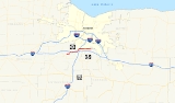
New York State Route 253 (NY 253) is a 10.83 miles (17.43 km) long east–west state highway
in Monroe County, New York
, United States
. The western terminus of the route is at NY 383
in the village of Scottsville
. Its eastern terminus is at NY 65
in the town of Pittsford
. NY 253 meets Interstate 390 and connects to the New York State Thruway
(Interstate 90) in the town of Henrietta
. The majority of NY 253 passes through either rural or residential areas; however, the midsection of NY 253 is located in a heavily commercial portion of Henrietta.
NY 253 originally extended from NY 36
in Mumford
to NY 64
south of the village of Pittsford
when it was assigned as part of the 1930 renumbering of state highways in New York. By 1938, it was truncated to Scottsville on its western end but also extended northeastward to Penfield
. The portion of NY 253 through East Rochester
and Penfield was realigned twice in the 1960s and 1970s before the route was cut back to NY 65 in Pittsford in the 1980s. Since that time, NY 253 has also been rerouted twice in Henrietta.
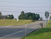
 NY 253 begins at an intersection with NY 383
in the village Scottsville
. It heads east out of the village and into the surrounding town of Wheatland
as Scottsville – West Henrietta Road. Just after crossing the Genesee River
into the town of Henrietta
, NY 253 turns northward to briefly parallel the river. After about 0.25 mile (0.402335 km), Scottsville – West Henrietta Road turns eastward; however, NY 253 continues northward onto Erie Station Road. The roadway gradually curves to the east, coming within 50 yards (45.7 m) of the New York State Thruway
(Interstate 90) and serving the highway's Scottsville service area. NY 253 and the Thruway follow parallel routings for 0.5 mile (0.80467 km) before NY 253 shifts slightly south to intersect East River Road, a highway connecting the village of Avon
to the city of Rochester
.
East of River Road, NY 253 crosses the Livonia, Avon and Lakeville Railroad
(LAL) and continues to parallel the Thruway through a lightly populated area of Henrietta toward the hamlet of West Henrietta. Instead of entering the hamlet, NY 253 leaves Erie Station Road and follows an industrial parkway named Thruway Park Drive around the northwestern edge of the community. Upon reaching the western end of Thruway Park Drive at NY 15
, NY 253 turns north, joining NY 15 on West Henrietta Road and crossing over the Thruway.
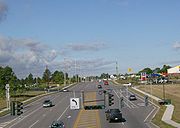
NY 15 and NY 253 continue northward along the heavily-developed and entirely commercial West Henrietta Road to Lehigh Station Road, where NY 253 splits from NY 15 and follows Lehigh Station Road eastward. Like West Henrietta Road before it, Lehigh Station Road is a major commercial strip, consisting of hotels, restaurants, and other establishments. This trend begins to cease as NY 253 meets Interstate 390 (and indirectly with the Thruway) at an interchange, and ceases entirely at a junction with Middle Road, a largely alternate route to I-390 between NY 251
in Rush and Calkins Road.
 Past Middle Road, NY 253 enters a predominantly residential neighborhood. It crosses a spur of the LAL that serves a pair of businesses on NY 253 and continues to the official town center of Henrietta, where it intersects NY 15A
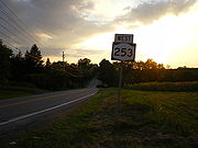
. NY 253 continues onward, meeting Pinnacle Road, a highway leading from NY 251 to NY 252
, 1 miles (1.6 km) east of NY 15A. East of Pinnacle Road, the amount of development along NY 253 declines sharply, and it continues eastward through open fields to its eastern terminus at NY 65
about 1 miles (1.6 km) east of the Henrietta–Pittsford
town line.
in the hamlet of Mumford
and followed Scottsville–Mumford Road to the village of Scottsville
. NY 253 had overlaps with NY 251
and NY 35
through Scottsville, then continued east on Scottsville – West Henrietta, East River, and Erie Station Roads to the Henrietta
hamlet of West Henrietta. Here, it turned north to follow NY 2 (now NY 15
) to Lehigh Station Road, which it followed eastward to its end at NY 65
in the town of Pittsford
. NY 253 continued on, however, joining NY 65 northward to Calkins Road. It then followed Calkins and Mendon Center Roads to NY 64
south of the village of Pittsford
.
 NY 253 was extended northward through Pittsford and East Rochester
by 1936 along NY 64, NY 15 (now NY 96
), and Washington Street to a new terminus at NY 33
(modern NY 441
) in Penfield
. Ca. 1938, NY 35 was rerouted south of Scottsville to follow the routing of NY 253 to Mumford. As a result, NY 253 was truncated to the northern terminus of its overlap with NY 35 (modern NY 383
) north of the village center.
in Penfield's Linear Park was closed to vehicular traffic in the 1960s. The portion of North Washington Street north of the creek, now severed from the rest of the route, was renamed Linear Park Drive. NY 253, meanwhile, was rerouted north of the junction of North Washington Street and Linden Avenue to follow Linden Avenue eastward across Irondequoit Creek to Whitney Road in Perinton
. It then turned north to follow Whitney and Five Mile Line Roads to the Four Corners of Penfield, where it ended at NY 441.
An extension of Panorama Trail, named Panorama Trail South, was built from Panorama Creek Drive south to North Washington Street in the late 1960s and early 1970s to connect Washington to the new NY 441 limited-access highway being constructed through the towns of Brighton
and Penfield. NY 253 was rerouted by 1971 to follow North Washington Street and the new highway northwest to the latter road's interchange with NY 441.
 In the latter half of the 1980s, NY 253 was truncated southward to the southern terminus of its overlap with NY 65 in Pittsford. The former routing of NY 253 north of NY 96 was redesignated as NY 153
while the segment between NY 65 and NY 64 on Calkins and Mendon Center Roads became NY 943C, an unsigned reference route 1.68 miles (2.7 km) in length.
westward toward the Genesee River
, then loop back to the southeast to end at Farrell Road. Ultimately, the proposed loop to Farrell Road was scrapped in favor of a more direct connection with Scottsville – West Henrietta Road. The new highway became part of a rerouted NY 253 on April 1, 1984, when it was added to the state highway system as part of a highway maintenance swap between the state of New York
and Monroe County
. In the swap, ownership and maintenance of the former routing of NY 253 on Scottsville – West Henrietta Road was transferred from the state to the town of Henrietta while the East River Road portion was given to Monroe County and is now part of County Route 84.
In the late 1990s, the amount of traffic at the intersection between NY 253 (Erie Station Road) and NY 15 (West Henrietta Road) began to increase due to the creation of the Thruway Industrial Park. Due to the presence of historical buildings at the intersection, the junction could not be widened to handle the increased traffic flow. As a result, plans were developed to construct a bypass of the intersection to the northwest. On July 29, 1999, Governor George Pataki
announced that the state of New York would contribute $1 million (equivalent to $ in ) toward the construction of the highway, which would be an extension of Thruway Park Drive. It opened to traffic in 2000 as a realignment of NY 253. The roadway was dedicated to the town of Henrietta, and although a proposal was made that would transfer maintenance of the highway to the New York State Department of Transportation
, it remains a town highway today. The 0.96 miles (1.54 km) long former routing of NY 253 on Erie Station Road became NY 943E, an unsigned reference route.
State highway
State highway, state road or state route can refer to one of three related concepts, two of them related to a state or provincial government in a country that is divided into states or provinces :#A...
in Monroe County, New York
Monroe County, New York
Monroe County is a county located in the U.S. state of New York. As of the 2010 census, the population was 744,344. It is named after James Monroe, fifth President of the United States of America. Its county seat is the city of Rochester....
, United States
United States
The United States of America is a federal constitutional republic comprising fifty states and a federal district...
. The western terminus of the route is at NY 383
New York State Route 383
New York State Route 383 is an north–south state highway in Monroe County, New York, in the United States. The southern terminus of the route is at an intersection with NY 36 in the hamlet of Mumford within the town of Wheatland. Its northern terminus is at a junction with NY 31 in...
in the village of Scottsville
Scottsville, New York
Scottsville is a village in southwestern Monroe County, New York, United States, and is in the northeastern part of the Town of Wheatland. The population was 2,128 at the 2000 census. The village is named after an early settler, Isaac Scott...
. Its eastern terminus is at NY 65
New York State Route 65
New York State Route 65 is a north–south state highway located in the western portion of New York in the United States. It extends for from an intersection with U.S. Route 20 and NY 5 in the Ontario County town of West Bloomfield to a junction with NY 96 in the Monroe County...
in the town of Pittsford
Pittsford (town), New York
Pittsford is a town in Monroe County, New York, United States and is an affluent suburb of Rochester. The population was 29,405 at the 2010 census....
. NY 253 meets Interstate 390 and connects to the New York State Thruway
New York State Thruway
The New York State Thruway is a system of limited-access highways located within the state of New York in the United States. The system, known officially as the Governor Thomas E. Dewey Thruway for former New York Governor Thomas E. Dewey, is operated by the New York State Thruway Authority and...
(Interstate 90) in the town of Henrietta
Henrietta, New York
Henrietta is a town in Monroe County, New York, United States. It is a suburb of Rochester. The population was 42,581 at the 2010 census. Established in 1818, the town is named after Henrietta Laura Pulteney, Countess of Bath, daughter of Sir William Pulteney, 5th Baronet, a major British...
. The majority of NY 253 passes through either rural or residential areas; however, the midsection of NY 253 is located in a heavily commercial portion of Henrietta.
NY 253 originally extended from NY 36
New York State Route 36
New York State Route 36 is a north–south state highway in the western part of New York in the United States. The highway extends for from the Pennsylvania state line at Troupsburg, Steuben County northward to Ogden, Monroe County, where it ends at an intersection with NY 31...
in Mumford
Mumford, New York
The hamlet of Mumford lies on the west side of the Town of Wheatland, south of Oatka Creek on NY 36 and south of the terminus of NY 383.-History:The story of Mumford has been written by several local historians...
to NY 64
New York State Route 64
New York State Route 64 is a north–south state highway in the Finger Lakes region of New York in the United States. Its southern terminus is at an intersection with NY 21 in the hamlet of Bristol Springs within the town of South Bristol, Ontario County...
south of the village of Pittsford
Pittsford (village), New York
Pittsford is a village in Monroe County, New York, United States. The population was 1,418 at the 2000 census. It is named after Pittsford, Vermont, the native town of a founding father....
when it was assigned as part of the 1930 renumbering of state highways in New York. By 1938, it was truncated to Scottsville on its western end but also extended northeastward to Penfield
Penfield, New York
Penfield is a town in Monroe County, New York, United States. The population was 36,242 at the 2010 census.The town was incorporated in 1810 by the proprietor, Daniel Penfield, who purchased the town lands in 1795 and moved to the area in 1809. Penfield is a suburb of Rochester, New York...
. The portion of NY 253 through East Rochester
East Rochester, New York
East Rochester is a coterminous town and village located southeast of the City of Rochester in Monroe County, New York. The village, home to about 6,587 people, is bounded by Pittsford to the west and south and Perinton to the north and east. The southern boundary is delimited by New York State...
and Penfield was realigned twice in the 1960s and 1970s before the route was cut back to NY 65 in Pittsford in the 1980s. Since that time, NY 253 has also been rerouted twice in Henrietta.
Route description
New York State Route 383
New York State Route 383 is an north–south state highway in Monroe County, New York, in the United States. The southern terminus of the route is at an intersection with NY 36 in the hamlet of Mumford within the town of Wheatland. Its northern terminus is at a junction with NY 31 in...
in the village Scottsville
Scottsville, New York
Scottsville is a village in southwestern Monroe County, New York, United States, and is in the northeastern part of the Town of Wheatland. The population was 2,128 at the 2000 census. The village is named after an early settler, Isaac Scott...
. It heads east out of the village and into the surrounding town of Wheatland
Wheatland, New York
Wheatland is a town in Monroe County, New York, United States. The population was 4,775 at the 2010 census. The town is home to Genesee Country Village and Museum.The Town of Wheatland is located in the southwest part of the county....
as Scottsville – West Henrietta Road. Just after crossing the Genesee River
Genesee River
The Genesee River is a North American river flowing northward through the Twin Tiers of Pennsylvania and New York. The river provided the original power for the Rochester area's 19th century mills and still provides hydroelectric power for downtown Rochester....
into the town of Henrietta
Henrietta, New York
Henrietta is a town in Monroe County, New York, United States. It is a suburb of Rochester. The population was 42,581 at the 2010 census. Established in 1818, the town is named after Henrietta Laura Pulteney, Countess of Bath, daughter of Sir William Pulteney, 5th Baronet, a major British...
, NY 253 turns northward to briefly parallel the river. After about 0.25 mile (0.402335 km), Scottsville – West Henrietta Road turns eastward; however, NY 253 continues northward onto Erie Station Road. The roadway gradually curves to the east, coming within 50 yards (45.7 m) of the New York State Thruway
New York State Thruway
The New York State Thruway is a system of limited-access highways located within the state of New York in the United States. The system, known officially as the Governor Thomas E. Dewey Thruway for former New York Governor Thomas E. Dewey, is operated by the New York State Thruway Authority and...
(Interstate 90) and serving the highway's Scottsville service area. NY 253 and the Thruway follow parallel routings for 0.5 mile (0.80467 km) before NY 253 shifts slightly south to intersect East River Road, a highway connecting the village of Avon
Avon (village), New York
Avon is a village in Livingston County, New York, USA. The population was 2,977 at the 2000 census. The village is named after the River Avon. ....
to the city of Rochester
Rochester, New York
Rochester is a city in Monroe County, New York, south of Lake Ontario in the United States. Known as The World's Image Centre, it was also once known as The Flour City, and more recently as The Flower City...
.
East of River Road, NY 253 crosses the Livonia, Avon and Lakeville Railroad
Livonia, Avon and Lakeville Railroad
The Livonia, Avon and Lakeville Railroad is a short line railroad that operates in Livingston County and Monroe County in New York, United States...
(LAL) and continues to parallel the Thruway through a lightly populated area of Henrietta toward the hamlet of West Henrietta. Instead of entering the hamlet, NY 253 leaves Erie Station Road and follows an industrial parkway named Thruway Park Drive around the northwestern edge of the community. Upon reaching the western end of Thruway Park Drive at NY 15
New York State Route 15
New York State Route 15 is a north–south state highway located in western New York in the United States. The southern terminus of the route is officially at Interstate 390 exit 3 south of the village of Wayland, although some signage indicating that NY 15 continues south to...
, NY 253 turns north, joining NY 15 on West Henrietta Road and crossing over the Thruway.
NY 15 and NY 253 continue northward along the heavily-developed and entirely commercial West Henrietta Road to Lehigh Station Road, where NY 253 splits from NY 15 and follows Lehigh Station Road eastward. Like West Henrietta Road before it, Lehigh Station Road is a major commercial strip, consisting of hotels, restaurants, and other establishments. This trend begins to cease as NY 253 meets Interstate 390 (and indirectly with the Thruway) at an interchange, and ceases entirely at a junction with Middle Road, a largely alternate route to I-390 between NY 251
New York State Route 251
New York State Route 251 is an east–west state highway in western New York in the United States. It extends for from NY 383 in Scottsville, Monroe County, to NY 96 in the town of Victor, Ontario County...
in Rush and Calkins Road.
New York State Route 15A
New York State Route 15A is a north–south state highway located in the western portion of New York in the United States. It serves as an easterly alternate route of NY 15, beginning in the Livingston County town of Springwater and ending to the north in the Monroe County city of...
. NY 253 continues onward, meeting Pinnacle Road, a highway leading from NY 251 to NY 252
New York State Route 252
New York State Route 252 is an east–west state highway south of Rochester in Monroe County, New York, in the United States. The western terminus of the route is at an intersection with NY 33A in Chili and the eastern terminus is at a junction with NY 64 and NY 96 in the village...
, 1 miles (1.6 km) east of NY 15A. East of Pinnacle Road, the amount of development along NY 253 declines sharply, and it continues eastward through open fields to its eastern terminus at NY 65
New York State Route 65
New York State Route 65 is a north–south state highway located in the western portion of New York in the United States. It extends for from an intersection with U.S. Route 20 and NY 5 in the Ontario County town of West Bloomfield to a junction with NY 96 in the Monroe County...
about 1 miles (1.6 km) east of the Henrietta–Pittsford
Pittsford (town), New York
Pittsford is a town in Monroe County, New York, United States and is an affluent suburb of Rochester. The population was 29,405 at the 2010 census....
town line.
Establishment and early routing
NY 253 was assigned as part of the 1930 renumbering of state highways in New York. It initially began at NY 36New York State Route 36
New York State Route 36 is a north–south state highway in the western part of New York in the United States. The highway extends for from the Pennsylvania state line at Troupsburg, Steuben County northward to Ogden, Monroe County, where it ends at an intersection with NY 31...
in the hamlet of Mumford
Mumford, New York
The hamlet of Mumford lies on the west side of the Town of Wheatland, south of Oatka Creek on NY 36 and south of the terminus of NY 383.-History:The story of Mumford has been written by several local historians...
and followed Scottsville–Mumford Road to the village of Scottsville
Scottsville, New York
Scottsville is a village in southwestern Monroe County, New York, United States, and is in the northeastern part of the Town of Wheatland. The population was 2,128 at the 2000 census. The village is named after an early settler, Isaac Scott...
. NY 253 had overlaps with NY 251
New York State Route 251
New York State Route 251 is an east–west state highway in western New York in the United States. It extends for from NY 383 in Scottsville, Monroe County, to NY 96 in the town of Victor, Ontario County...
and NY 35
New York State Route 35 (1927 – early 1940s)
New York State Route 35 was a state highway in the Finger Lakes region of New York, United States. The western terminus of the route was at NY 36 in the hamlet of Mumford within the town of Wheatland. Its eastern terminus was at U.S. Route 104 in the hamlet of Ontario Center within...
through Scottsville, then continued east on Scottsville – West Henrietta, East River, and Erie Station Roads to the Henrietta
Henrietta, New York
Henrietta is a town in Monroe County, New York, United States. It is a suburb of Rochester. The population was 42,581 at the 2010 census. Established in 1818, the town is named after Henrietta Laura Pulteney, Countess of Bath, daughter of Sir William Pulteney, 5th Baronet, a major British...
hamlet of West Henrietta. Here, it turned north to follow NY 2 (now NY 15
New York State Route 15
New York State Route 15 is a north–south state highway located in western New York in the United States. The southern terminus of the route is officially at Interstate 390 exit 3 south of the village of Wayland, although some signage indicating that NY 15 continues south to...
) to Lehigh Station Road, which it followed eastward to its end at NY 65
New York State Route 65
New York State Route 65 is a north–south state highway located in the western portion of New York in the United States. It extends for from an intersection with U.S. Route 20 and NY 5 in the Ontario County town of West Bloomfield to a junction with NY 96 in the Monroe County...
in the town of Pittsford
Pittsford (town), New York
Pittsford is a town in Monroe County, New York, United States and is an affluent suburb of Rochester. The population was 29,405 at the 2010 census....
. NY 253 continued on, however, joining NY 65 northward to Calkins Road. It then followed Calkins and Mendon Center Roads to NY 64
New York State Route 64
New York State Route 64 is a north–south state highway in the Finger Lakes region of New York in the United States. Its southern terminus is at an intersection with NY 21 in the hamlet of Bristol Springs within the town of South Bristol, Ontario County...
south of the village of Pittsford
Pittsford (village), New York
Pittsford is a village in Monroe County, New York, United States. The population was 1,418 at the 2000 census. It is named after Pittsford, Vermont, the native town of a founding father....
.
East Rochester, New York
East Rochester is a coterminous town and village located southeast of the City of Rochester in Monroe County, New York. The village, home to about 6,587 people, is bounded by Pittsford to the west and south and Perinton to the north and east. The southern boundary is delimited by New York State...
by 1936 along NY 64, NY 15 (now NY 96
New York State Route 96
New York State Route 96 is a northwest–southeast state highway in the Finger Lakes region of New York in the United States. The southern terminus of the route is at an interchange with NY 17 in the Southern Tier village of Owego, Tioga County. Its northern terminus is at a junction with...
), and Washington Street to a new terminus at NY 33
New York State Route 33
New York State Route 33 is an east–west state highway in western New York in the United States. The route extends for just under from NY 5 in Buffalo in the west to NY 31 in Rochester in the east. It is, in fact, the only state highway that directly connects both cities, although...
(modern NY 441
New York State Route 441
New York State Route 441 is an east–west state highway in the eastern suburbs of Rochester, New York, United States. Its western terminus is at NY 96 in Brighton, and its eastern terminus is at NY 350 in Walworth. The portion of NY 441 in Brighton and western Penfield is a...
) in Penfield
Penfield, New York
Penfield is a town in Monroe County, New York, United States. The population was 36,242 at the 2010 census.The town was incorporated in 1810 by the proprietor, Daniel Penfield, who purchased the town lands in 1795 and moved to the area in 1809. Penfield is a suburb of Rochester, New York...
. Ca. 1938, NY 35 was rerouted south of Scottsville to follow the routing of NY 253 to Mumford. As a result, NY 253 was truncated to the northern terminus of its overlap with NY 35 (modern NY 383
New York State Route 383
New York State Route 383 is an north–south state highway in Monroe County, New York, in the United States. The southern terminus of the route is at an intersection with NY 36 in the hamlet of Mumford within the town of Wheatland. Its northern terminus is at a junction with NY 31 in...
) north of the village center.
Penfield realignments and truncation
The bridge carrying NY 253 over Irondequoit CreekIrondequoit Creek
Irondequoit Creek is a stream in eastern Monroe County, New York that feeds Irondequoit Bay. It actually begins in rural West Bloomfield in Ontario County, flowing north into the town of Mendon in Monroe County...
in Penfield's Linear Park was closed to vehicular traffic in the 1960s. The portion of North Washington Street north of the creek, now severed from the rest of the route, was renamed Linear Park Drive. NY 253, meanwhile, was rerouted north of the junction of North Washington Street and Linden Avenue to follow Linden Avenue eastward across Irondequoit Creek to Whitney Road in Perinton
Perinton, New York
Perinton is a town in Monroe County, New York, United States. The population was 46,090 at the 2000 census.The Village of Fairport, New York is within the town on the Erie Canal. Perinton is adjacent to the village of East Rochester , and the towns of Victor , Macedon , Pittsford , and Penfield...
. It then turned north to follow Whitney and Five Mile Line Roads to the Four Corners of Penfield, where it ended at NY 441.
An extension of Panorama Trail, named Panorama Trail South, was built from Panorama Creek Drive south to North Washington Street in the late 1960s and early 1970s to connect Washington to the new NY 441 limited-access highway being constructed through the towns of Brighton
Brighton, Monroe County, New York
Brighton is a town in Monroe County, New York, USA. The population was 36,609 at the 2010 census.-History:The Town of Brighton, located on the southeast border of the city of Rochester, was originally settled approximately 1790, and formally established in 1814—earning it recognition as one...
and Penfield. NY 253 was rerouted by 1971 to follow North Washington Street and the new highway northwest to the latter road's interchange with NY 441.
New York State Route 153
New York State Route 153 is a long north–south state highway located in the eastern suburbs of Rochester, New York, United States. The southern terminus of the route is at NY 96 in the village of Pittsford. Its northern terminus is at an interchange with NY 441 in the town of...
while the segment between NY 65 and NY 64 on Calkins and Mendon Center Roads became NY 943C, an unsigned reference route 1.68 miles (2.7 km) in length.
Henrietta realignments
To the southwest in Henrietta, construction began by 1978 on an extension of Erie Station Road in the vicinity of Scottsville – West Henrietta and East River Roads. The new roadway, as proposed, would begin at the junction of Erie Station and East River Roads and parallel the New York State ThruwayNew York State Thruway
The New York State Thruway is a system of limited-access highways located within the state of New York in the United States. The system, known officially as the Governor Thomas E. Dewey Thruway for former New York Governor Thomas E. Dewey, is operated by the New York State Thruway Authority and...
westward toward the Genesee River
Genesee River
The Genesee River is a North American river flowing northward through the Twin Tiers of Pennsylvania and New York. The river provided the original power for the Rochester area's 19th century mills and still provides hydroelectric power for downtown Rochester....
, then loop back to the southeast to end at Farrell Road. Ultimately, the proposed loop to Farrell Road was scrapped in favor of a more direct connection with Scottsville – West Henrietta Road. The new highway became part of a rerouted NY 253 on April 1, 1984, when it was added to the state highway system as part of a highway maintenance swap between the state of New York
New York
New York is a state in the Northeastern region of the United States. It is the nation's third most populous state. New York is bordered by New Jersey and Pennsylvania to the south, and by Connecticut, Massachusetts and Vermont to the east...
and Monroe County
Monroe County, New York
Monroe County is a county located in the U.S. state of New York. As of the 2010 census, the population was 744,344. It is named after James Monroe, fifth President of the United States of America. Its county seat is the city of Rochester....
. In the swap, ownership and maintenance of the former routing of NY 253 on Scottsville – West Henrietta Road was transferred from the state to the town of Henrietta while the East River Road portion was given to Monroe County and is now part of County Route 84.
In the late 1990s, the amount of traffic at the intersection between NY 253 (Erie Station Road) and NY 15 (West Henrietta Road) began to increase due to the creation of the Thruway Industrial Park. Due to the presence of historical buildings at the intersection, the junction could not be widened to handle the increased traffic flow. As a result, plans were developed to construct a bypass of the intersection to the northwest. On July 29, 1999, Governor George Pataki
George Pataki
George Elmer Pataki is an American politician who was the 53rd Governor of New York. A member of the Republican Party, Pataki served three consecutive four-year terms from January 1, 1995 until December 31, 2006.- Early life :...
announced that the state of New York would contribute $1 million (equivalent to $ in ) toward the construction of the highway, which would be an extension of Thruway Park Drive. It opened to traffic in 2000 as a realignment of NY 253. The roadway was dedicated to the town of Henrietta, and although a proposal was made that would transfer maintenance of the highway to the New York State Department of Transportation
New York State Department of Transportation
The New York State Department of Transportation is responsible for the development and operation of highways, railroads, mass transit systems, ports, waterways and aviation facilities in the U.S...
, it remains a town highway today. The 0.96 miles (1.54 km) long former routing of NY 253 on Erie Station Road became NY 943E, an unsigned reference route.
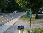
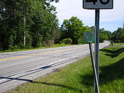
Major intersections