
New York State Route 21
Encyclopedia
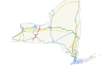
New York State Route 21 (NY 21) is a state highway
extending for 99.99 miles (160.92 km) through the western part of New York
in the United States
. The southern terminus of the route is at NY 417
in Andover
. The northern terminus is at NY 104
in Williamson
. In between, NY 21 serves the cities of Hornell
and Canandaigua
and intersects several major east–west routes, including the Southern Tier Expressway near Hornell, the conjoined
routes of U.S. Route 20 (US 20) and NY 5
in Canandaigua, the New York State Thruway
in Manchester
, and NY 31
in Palmyra
.
NY 21 originally extended from the Pennsylvania state line in the south to Lake Ontario
in the north when it was assigned as part of the 1930 renumbering of state highways in New York. South of Hornell
, the route followed modern NY 36
. NY 21 was rerouted to follow its current alignment south of Hornell
in the 1950s and truncated on its northern end to Williamson
in 1980. Other changes, namely realignments to bypass communities along the route, have also occurred.
. The route continues north, paralleling the Western New York and Pennsylvania Railroad to Alfred Station (east of Alfred
), where it meets the eastern terminus of NY 244
. NY 21 heads northeast through Almond
to Hornell
, briefly paralleling the Southern Tier Expressway (Interstate 86
or I-86 and NY 17
) before intersecting NY 36
in the center of Hornell. NY 21 turns north onto NY 36, separating from the Southern Tier Line and forming a concurrency
with NY 36 north along the Maple City Bypass. At North Hornell
, the two routes split near I-86/NY 17 exit 34.
 From Hornell, NY 21 heads northeast through Fremont
to Haskinville, passing west of Look Lake, then north to Wayland
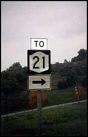
, where it intersects I-390 and NY 15
at exit 3 south of the village. NY 15 begins here and joins NY 21 north into the village. In the center of Wayland, NY 15 and NY 21 separate upon intersecting NY 63
. Past Wayland, NY 21 follows an east–west alignment to North Cohocton, where it meets the northern terminus of NY 371
. Upon exiting the village, NY 21 turns to the northeast toward Naples
. South of the village, NY 21 intersects the northern end of NY 53; north of the village, the route passes the southern terminus of NY 245
.
, where it meets the southern terminus of NY 64
in Bristol Springs adjacent to Canandaigua Lake
. The route remains in close proximity to the lake to the town of Canandaigua
, where it meets US 20 and NY 5
(Western Boulevard) west of the city of Canandaigua
. NY 21 turns east, following US 20 and NY 5 around the southwestern portion of the city. The overlap between the three routes ends 1.5 miles (2.4 km) later at South Main Street, where NY 21 joins NY 332
(which begins at the intersection) north through downtown Canandaigua. At Gibson Street, NY 21 breaks from NY 332 and exits the city to the northeast.
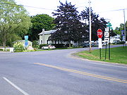
Outside the Canandaigua city limits, the area surrounding NY 21 becomes rural once again. The route heads north through farmland to the adjacent villages of Shortsville
and Manchester
, where NY 21 intersects both NY 96
and the New York State Thruway
(I-90) at exit 43 just north of Manchester. Past the Thruway, NY 21 becomes rural in nature once more as it passes through the northern portion of Ontario County. Upon crossing into Wayne County
, the area around NY 21 becomes more developed as it enters Palmyra
.
Within the village, NY 21 briefly overlaps NY 31 along East Main Street before crossing both the Erie Canal
and the CSX Transportation
-owned Rochester Subdivision
as it exits the village. The portion of NY 21 between the southern village line and NY 31 is maintained by the village. From Palmyra to Williamson
, the land surrounding NY 21 is predominantly rural in nature. However, midway between the two locations, NY 21 comes close to Marion
, which it bypasses to the west. In Williamson, NY 21 comes to an end at NY 104
.
, the path of modern NY 21 north of Canandaigua
was part of an old Native American
trail connecting Seneca Lake to Lake Ontario
by way of Canandaigua Lake
. The trail began in the vicinity of Geneva and went west to Canandaigua on a path now occupied by US 20 and NY 5
. It continued north from Canandaigua, passing through the villages of Palmyra
and Marion
before reaching the Lake Ontario shoreline at Pultneyville
. Construction to convert the Canandaigua–Marion section of the trail into a road was completed in 1794. The remainder of the trail north to Pultneyville was converted into a road approximately three years later.
 The Canandaigua–Pultneyville highway served as a post road
in the years that followed. At some point, the section of the highway between Palmyra and Marion, initially a corduroy road
, was rebuilt as a plank road
and tolled. The highway fell into disrepair over the years, leading travelers to conceive ways to avoid paying toll. The toll booths were eventually removed. The road was later covered with dirt and served as a stage road. By the 1920s, the state of New York
had assumed ownership of the Canandaigua–Pultneyville highway. In the mid-1920s, it became part of NY 72, a north–south highway extending from NY 52 in Naples
to the Lake Ontario shoreline in Pultneyville by way of the western side of Canandaigua Lake.
to Pultneyville. It followed what is now NY 36
from the state line to Hornell
and modern County Route 121 (CR 121), NY 415
, and NY 371
between Loon Lake and North Cohocton (via Cohocton
). The remainder of NY 21 roughly followed its current alignment. At the same time, what is now NY 21 from Andover
to Hornell
was designated as the western half of NY 17F while the section between Loon Lake and modern NY 415 was assigned NY 371. The remaining piece around Wayland
was part of NY 2 south of Wayland and part of the new NY 39
from Wayland to North Cohocton. NY 39 overlapped NY 21 from North Cohocton to Naples, where it forked from NY 21 and continued east on modern NY 245
.
Several portions of current NY 21 south of Naples had carried designations prior to 1930. In 1924, the Andover–Hornell segment was designated as part of NY 17
; at the same time, the short piece between modern NY 415 and the center of Wayland became part of NY 4. By 1926, the portion connecting Wayland to Naples was included in the new NY 52. NY 4 was renumbered to NY 2 in 1927 to eliminate numerical duplication with the new US 4.
) by the following year. In the early 1940s, the NY 17F designation was eliminated and replaced with an extended NY 36
from Andover to Hornell. The alignments of NY 36 and NY 21 south of Hornell were flipped in the early 1950s, placing both routes on their current alignments south of the city.
On April 1, 1980, NY 21 was truncated to its present northern terminus at NY 104
in Williamson
as part of a highway maintenance swap between New York State and Wayne County
. In the swap, ownership and maintenance of NY 21 north of Williamson was transferred from the state of New York to the county in exchange for maintenance of NY 441
between the Monroe
–Wayne county line and NY 350
. The former routing of NY 21 north to Lake Road
(CR 101) in Pultneyville is now designated as CR 120.
Until the 1980s, NY 21 entered Canandaigua on Bristol Street and followed it to South Main Street (then-US 20 and NY 5
), where it joined its current alignment. When the Western Bypass around the southwestern fringe of the city was constructed in the late 1970s and early 1980s, US 20 and NY 5 were realigned to follow the highway around the city. NY 21 was also realigned at this time to follow its modern routing on the bypass and South Main Street. The segment of Bristol Street vacated by NY 21 between the Western Bypass and the Canandaigua city line was maintained by the New York State Department of Transportation
as unsigned NY 943A until September 1, 1996, when maintenance of the road was turned over to the town of Canandaigua
. However, the designation remained in NYSDOT documents until 2007.
. When it was assigned as part of the 1930 renumbering of state highways in New York, it began at NY 21 north of the village of Naples
and ran along the east shore of the lake to eastern Canandaigua
, where it ended at US 20
and NY 5
. In between, NY 21A passed through the lakeside hamlet of Vine Valley. The route was truncated ca. 1939 to begin in Vine Valley, separating it from its parent route. It was eliminated entirely in the early 1940s when most of NY 21A was absorbed by NY 364
.
State highway
State highway, state road or state route can refer to one of three related concepts, two of them related to a state or provincial government in a country that is divided into states or provinces :#A...
extending for 99.99 miles (160.92 km) through the western part of New York
New York
New York is a state in the Northeastern region of the United States. It is the nation's third most populous state. New York is bordered by New Jersey and Pennsylvania to the south, and by Connecticut, Massachusetts and Vermont to the east...
in the United States
United States
The United States of America is a federal constitutional republic comprising fifty states and a federal district...
. The southern terminus of the route is at NY 417
New York State Route 417
New York State Route 417 is an east–west state highway located in the Southern Tier of New York in the United States. It begins at exit 20 of the Southern Tier Expressway in the city of Salamanca and ends at a junction with NY 415 in Painted Post, west of the city of Corning...
in Andover
Andover (village), New York
Andover is a village located in the Town of Andover in Allegany County, New York, USA. The population was 1,073 at the 2000 census. The name is derived from Andover, Vermont....
. The northern terminus is at NY 104
New York State Route 104
New York State Route 104 is a long east–west state highway in Upstate New York, United States. It spans six counties and enters the vicinity of four cities—Niagara Falls, Lockport, Rochester, and Oswego—as it follows a routing largely parallel to that of the southern shoreline of Lake...
in Williamson
Williamson, New York
Williamson is an Upstate New York town in the northwest part of Wayne County, New York, U.S. on the south shore of Lake Ontario. The population was 6,777 at the time of the 2000 census. The town is named after Charles Williamson, a land agent of the Pultney Estate...
. In between, NY 21 serves the cities of Hornell
Hornell, New York
Hornell is a city in Steuben County, New York, United States. The population was 9,019 at the 2000 census. The city is named after the Hornell family, early settlers. Its current population has not yet been released by the new census....
and Canandaigua
Canandaigua (city), New York
Canandaigua is a city in Ontario County, New York, USA, of which it is the county seat. The population was 11,264 at the 2000 census...
and intersects several major east–west routes, including the Southern Tier Expressway near Hornell, the conjoined
Concurrency (road)
A concurrency, overlap, or coincidence in a road network is an instance of one physical road bearing two or more different highway, motorway, or other route numbers...
routes of U.S. Route 20 (US 20) and NY 5
New York State Route 5
New York State Route 5 is a state highway that extends for across the state of New York in the United States. It begins at the Pennsylvania state line in the Chautauqua County town of Ripley and passes through Buffalo, Syracuse, Utica, Schenectady, and several other smaller cities and...
in Canandaigua, the New York State Thruway
New York State Thruway
The New York State Thruway is a system of limited-access highways located within the state of New York in the United States. The system, known officially as the Governor Thomas E. Dewey Thruway for former New York Governor Thomas E. Dewey, is operated by the New York State Thruway Authority and...
in Manchester
Manchester (village), New York
Manchester is a village located within the Town of Manchester in Ontario County, New York, USA. The population was 1,475 at the 2000 census. The village was named after Manchester in England....
, and NY 31
New York State Route 31
New York State Route 31 is a state highway that extends for across western and central New York in the United States. The western terminus of the route is at an intersection with NY 104 in the city of Niagara Falls. Its eastern terminus is at a traffic circle with NY 26 in Vernon...
in Palmyra
Palmyra (village), New York
Palmyra is a village in Wayne County, New York, United States. The population was 3,490 at the 2000 census. The village, along with the town, is named after Palmyra in present-day Syria.The Village of Palmyra is in the Town of Palmyra...
.
NY 21 originally extended from the Pennsylvania state line in the south to Lake Ontario
Lake Ontario
Lake Ontario is one of the five Great Lakes of North America. It is bounded on the north and southwest by the Canadian province of Ontario, and on the south by the American state of New York. Ontario, Canada's most populous province, was named for the lake. In the Wyandot language, ontarío means...
in the north when it was assigned as part of the 1930 renumbering of state highways in New York. South of Hornell
Hornell, New York
Hornell is a city in Steuben County, New York, United States. The population was 9,019 at the 2000 census. The city is named after the Hornell family, early settlers. Its current population has not yet been released by the new census....
, the route followed modern NY 36
New York State Route 36
New York State Route 36 is a north–south state highway in the western part of New York in the United States. The highway extends for from the Pennsylvania state line at Troupsburg, Steuben County northward to Ogden, Monroe County, where it ends at an intersection with NY 31...
. NY 21 was rerouted to follow its current alignment south of Hornell
Hornell, New York
Hornell is a city in Steuben County, New York, United States. The population was 9,019 at the 2000 census. The city is named after the Hornell family, early settlers. Its current population has not yet been released by the new census....
in the 1950s and truncated on its northern end to Williamson
Williamson, New York
Williamson is an Upstate New York town in the northwest part of Wayne County, New York, U.S. on the south shore of Lake Ontario. The population was 6,777 at the time of the 2000 census. The town is named after Charles Williamson, a land agent of the Pultney Estate...
in 1980. Other changes, namely realignments to bypass communities along the route, have also occurred.
Andover to Naples
NY 21 begins at NY 417 in AndoverAndover (village), New York
Andover is a village located in the Town of Andover in Allegany County, New York, USA. The population was 1,073 at the 2000 census. The name is derived from Andover, Vermont....
. The route continues north, paralleling the Western New York and Pennsylvania Railroad to Alfred Station (east of Alfred
Alfred (village), New York
Alfred is a village located in the Town of Alfred in Allegany County, New York, USA. The population was 3,954 at the 2000 census. The village is named after Alfred the Great....
), where it meets the eastern terminus of NY 244
New York State Route 244
New York State Route 244 is a state highway in Allegany County, New York, United States. It runs parallel to and south of the Southern Tier Expressway between the village of Belmont and the town of Alfred and it passes through more rugged and scenic countryside than the superhighway...
. NY 21 heads northeast through Almond
Almond (village), New York
Almond is a village located in the Town of Almond in Allegany County, New York, United States. The population was 461 at the 2000 census.Because the Village of Almond is located on the county line, a small part is in the Town of Hornellsville in Steuben County, New York.-Geography:According to the...
to Hornell
Hornell, New York
Hornell is a city in Steuben County, New York, United States. The population was 9,019 at the 2000 census. The city is named after the Hornell family, early settlers. Its current population has not yet been released by the new census....
, briefly paralleling the Southern Tier Expressway (Interstate 86
Interstate 86 (east)
Interstate 86 is an Interstate Highway that extends for through northwestern Pennsylvania and southern New York in the United States...
or I-86 and NY 17
New York State Route 17
New York State Route 17 is a state highway that extends for through the Southern Tier and Downstate regions of New York in the United States...
) before intersecting NY 36
New York State Route 36
New York State Route 36 is a north–south state highway in the western part of New York in the United States. The highway extends for from the Pennsylvania state line at Troupsburg, Steuben County northward to Ogden, Monroe County, where it ends at an intersection with NY 31...
in the center of Hornell. NY 21 turns north onto NY 36, separating from the Southern Tier Line and forming a concurrency
Concurrency (road)
A concurrency, overlap, or coincidence in a road network is an instance of one physical road bearing two or more different highway, motorway, or other route numbers...
with NY 36 north along the Maple City Bypass. At North Hornell
North Hornell, New York
North Hornell is a village in Steuben County, New York, United States. The population was 851 at the 2000 census.The Village of North Hornell is in the Town of Hornellsville, north of the City of Hornell.-History:...
, the two routes split near I-86/NY 17 exit 34.
Fremont, Steuben County, New York
Fremont is a town in Steuben County, New York, United States. The population was 964 at the 2000 census. The town is named after General John Fremont.The Town of Fremont is in the western part of Steuben County, northeast of Hornell, New York....
to Haskinville, passing west of Look Lake, then north to Wayland
Wayland (village), New York
Wayland is a village in Steuben County, New York, United States. The population was 1,893 at the 2000 census.The Village of Wayland is in north part of the Town of Wayland, near the north border of Steuben County.- History :...
, where it intersects I-390 and NY 15
New York State Route 15
New York State Route 15 is a north–south state highway located in western New York in the United States. The southern terminus of the route is officially at Interstate 390 exit 3 south of the village of Wayland, although some signage indicating that NY 15 continues south to...
at exit 3 south of the village. NY 15 begins here and joins NY 21 north into the village. In the center of Wayland, NY 15 and NY 21 separate upon intersecting NY 63
New York State Route 63
New York State Route 63 is a state highway in the western part of New York in the United States. The southern terminus of the route is at an intersection with NY 15 and NY 21 in the village of Wayland in Steuben County. Its northern end is at a junction with NY 18 in the town...
. Past Wayland, NY 21 follows an east–west alignment to North Cohocton, where it meets the northern terminus of NY 371
New York State Route 371
New York State Route 371 is a north–south state highway in Steuben County, New York, in the United States. It runs for from an intersection with NY 415 in the village of Cohocton to a junction with NY 21 in the town of Cohocton. NY 371 follows the Cohocton River and the main...
. Upon exiting the village, NY 21 turns to the northeast toward Naples
Naples (village), New York
Naples is a village in Ontario County, New York, USA. The population was 1,072 at the 2000 census.The Village of Naples is in the Town of Naples. Naples is in the center of an important grape-growing region.- History :...
. South of the village, NY 21 intersects the northern end of NY 53; north of the village, the route passes the southern terminus of NY 245
New York State Route 245
New York State Route 245 is a state highway in the Finger Lakes region of New York in the United States. The southern terminus of the route is at NY 21 in Naples. The northern terminus is at NY 5, U.S. Route 20 and NY 14A west of Geneva...
.
Naples to Williamson
NY 21 continues north through the hills of rural Ontario CountyOntario County, New York
As of the census of 2000, there were 100,224 people, 38,370 households, and 26,360 families residing in the county. The population density was 156 people per square mile . There were 42,647 housing units at an average density of 66 per square mile...
, where it meets the southern terminus of NY 64
New York State Route 64
New York State Route 64 is a north–south state highway in the Finger Lakes region of New York in the United States. Its southern terminus is at an intersection with NY 21 in the hamlet of Bristol Springs within the town of South Bristol, Ontario County...
in Bristol Springs adjacent to Canandaigua Lake
Canandaigua Lake
Canandaigua Lake is the fourth largest of the Finger Lakes, in the U.S. state of New York. The city of Canandaigua is located at the northern shore of the lake and the village of Naples is just a few miles south of the southern end...
. The route remains in close proximity to the lake to the town of Canandaigua
Canandaigua (town), New York
Canandaigua is a town in Ontario County, New York, USA. The population was 7,649 at the 2000 census. The name is a native word for "the chosen spot" or "the chosen place."...
, where it meets US 20 and NY 5
New York State Route 5
New York State Route 5 is a state highway that extends for across the state of New York in the United States. It begins at the Pennsylvania state line in the Chautauqua County town of Ripley and passes through Buffalo, Syracuse, Utica, Schenectady, and several other smaller cities and...
(Western Boulevard) west of the city of Canandaigua
Canandaigua (city), New York
Canandaigua is a city in Ontario County, New York, USA, of which it is the county seat. The population was 11,264 at the 2000 census...
. NY 21 turns east, following US 20 and NY 5 around the southwestern portion of the city. The overlap between the three routes ends 1.5 miles (2.4 km) later at South Main Street, where NY 21 joins NY 332
New York State Route 332
New York State Route 332 is a north–south state highway that extends for through Ontario County in the Finger Lakes region of New York in the United States. The southern terminus of the route is at an intersection with U.S. Route 20, NY 5, and NY 21 just south of...
(which begins at the intersection) north through downtown Canandaigua. At Gibson Street, NY 21 breaks from NY 332 and exits the city to the northeast.
Outside the Canandaigua city limits, the area surrounding NY 21 becomes rural once again. The route heads north through farmland to the adjacent villages of Shortsville
Shortsville, New York
Shortsville is a village in Ontario County, New York, United States. The population was 1,320 at the 2000 census.The Village of Shortsville is in the southwest part of the Town of Manchester and is north of Canandaigua, NY.-History:...
and Manchester
Manchester (village), New York
Manchester is a village located within the Town of Manchester in Ontario County, New York, USA. The population was 1,475 at the 2000 census. The village was named after Manchester in England....
, where NY 21 intersects both NY 96
New York State Route 96
New York State Route 96 is a northwest–southeast state highway in the Finger Lakes region of New York in the United States. The southern terminus of the route is at an interchange with NY 17 in the Southern Tier village of Owego, Tioga County. Its northern terminus is at a junction with...
and the New York State Thruway
New York State Thruway
The New York State Thruway is a system of limited-access highways located within the state of New York in the United States. The system, known officially as the Governor Thomas E. Dewey Thruway for former New York Governor Thomas E. Dewey, is operated by the New York State Thruway Authority and...
(I-90) at exit 43 just north of Manchester. Past the Thruway, NY 21 becomes rural in nature once more as it passes through the northern portion of Ontario County. Upon crossing into Wayne County
Wayne County, New York
Wayne County is a county located in the US state of New York. It is part of the Rochester, New York Metropolitan Statistical Area and lies on the south shore of Lake Ontario, forming part of the northern border of the United States with Canada. The name honors General Anthony Wayne, an American...
, the area around NY 21 becomes more developed as it enters Palmyra
Palmyra (village), New York
Palmyra is a village in Wayne County, New York, United States. The population was 3,490 at the 2000 census. The village, along with the town, is named after Palmyra in present-day Syria.The Village of Palmyra is in the Town of Palmyra...
.
Within the village, NY 21 briefly overlaps NY 31 along East Main Street before crossing both the Erie Canal
Erie Canal
The Erie Canal is a waterway in New York that runs about from Albany, New York, on the Hudson River to Buffalo, New York, at Lake Erie, completing a navigable water route from the Atlantic Ocean to the Great Lakes. The canal contains 36 locks and encompasses a total elevation differential of...
and the CSX Transportation
CSX Transportation
CSX Transportation operates a Class I railroad in the United States known as the CSX Railroad. It is the main subsidiary of the CSX Corporation. The company is headquartered in Jacksonville, Florida, and owns approximately 21,000 route miles...
-owned Rochester Subdivision
Rochester Subdivision
The Rochester Subdivision is a railroad line owned by CSX Transportation in the U.S. state of New York. The line runs from Syracuse west to Buffalo along the former New York Central Railroad main line. At its east end, west of downtown Syracuse, the line becomes the Mohawk Subdivision...
as it exits the village. The portion of NY 21 between the southern village line and NY 31 is maintained by the village. From Palmyra to Williamson
Williamson, New York
Williamson is an Upstate New York town in the northwest part of Wayne County, New York, U.S. on the south shore of Lake Ontario. The population was 6,777 at the time of the 2000 census. The town is named after Charles Williamson, a land agent of the Pultney Estate...
, the land surrounding NY 21 is predominantly rural in nature. However, midway between the two locations, NY 21 comes close to Marion
Marion, New York
Marion is a town in Wayne County, New York, United States. The population was 4,974 as of the 2000 census. It is named after Revolutionary War hero Francis Marion. It is an interior town near the center of the county, about 20 miles east of Rochester, New York and 50 miles west of Syracuse, New...
, which it bypasses to the west. In Williamson, NY 21 comes to an end at NY 104
New York State Route 104
New York State Route 104 is a long east–west state highway in Upstate New York, United States. It spans six counties and enters the vicinity of four cities—Niagara Falls, Lockport, Rochester, and Oswego—as it follows a routing largely parallel to that of the southern shoreline of Lake...
.
Origins
Prior to the American RevolutionAmerican Revolution
The American Revolution was the political upheaval during the last half of the 18th century in which thirteen colonies in North America joined together to break free from the British Empire, combining to become the United States of America...
, the path of modern NY 21 north of Canandaigua
Canandaigua (city), New York
Canandaigua is a city in Ontario County, New York, USA, of which it is the county seat. The population was 11,264 at the 2000 census...
was part of an old Native American
Indigenous peoples of the Americas
The indigenous peoples of the Americas are the pre-Columbian inhabitants of North and South America, their descendants and other ethnic groups who are identified with those peoples. Indigenous peoples are known in Canada as Aboriginal peoples, and in the United States as Native Americans...
trail connecting Seneca Lake to Lake Ontario
Lake Ontario
Lake Ontario is one of the five Great Lakes of North America. It is bounded on the north and southwest by the Canadian province of Ontario, and on the south by the American state of New York. Ontario, Canada's most populous province, was named for the lake. In the Wyandot language, ontarío means...
by way of Canandaigua Lake
Canandaigua Lake
Canandaigua Lake is the fourth largest of the Finger Lakes, in the U.S. state of New York. The city of Canandaigua is located at the northern shore of the lake and the village of Naples is just a few miles south of the southern end...
. The trail began in the vicinity of Geneva and went west to Canandaigua on a path now occupied by US 20 and NY 5
New York State Route 5
New York State Route 5 is a state highway that extends for across the state of New York in the United States. It begins at the Pennsylvania state line in the Chautauqua County town of Ripley and passes through Buffalo, Syracuse, Utica, Schenectady, and several other smaller cities and...
. It continued north from Canandaigua, passing through the villages of Palmyra
Palmyra (village), New York
Palmyra is a village in Wayne County, New York, United States. The population was 3,490 at the 2000 census. The village, along with the town, is named after Palmyra in present-day Syria.The Village of Palmyra is in the Town of Palmyra...
and Marion
Marion, New York
Marion is a town in Wayne County, New York, United States. The population was 4,974 as of the 2000 census. It is named after Revolutionary War hero Francis Marion. It is an interior town near the center of the county, about 20 miles east of Rochester, New York and 50 miles west of Syracuse, New...
before reaching the Lake Ontario shoreline at Pultneyville
Pultneyville, New York
Pultneyville is a hamlet located in the Town of Williamson, Wayne County, New York, USA. Framing the mouth of Salmon Creek, it is on the northern border of the town, the southern shore of Lake Ontario. The hamlet was originally laid out in 1806 and is listed with the National Register of Historic...
. Construction to convert the Canandaigua–Marion section of the trail into a road was completed in 1794. The remainder of the trail north to Pultneyville was converted into a road approximately three years later.
Post road
For other uses, see Post Road .A post road is a road designated for the transportation of postal mail. In past centuries only major towns had a post house, and the roads used by post riders or mail coaches to carry mail among them were particularly important ones or, due to the special attention...
in the years that followed. At some point, the section of the highway between Palmyra and Marion, initially a corduroy road
Corduroy road
A corduroy road or log road is a type of road made by placing sand-covered logs perpendicular to the direction of the road over a low or swampy area....
, was rebuilt as a plank road
Plank road
A plank road or puncheon is a dirt path or road covered with a series of planks, similar to the wooden sidewalks one would see in a Western movie. Plank roads were very popular in Ontario, the U.S. Northeast and U.S. Midwest in the first half of the 19th century...
and tolled. The highway fell into disrepair over the years, leading travelers to conceive ways to avoid paying toll. The toll booths were eventually removed. The road was later covered with dirt and served as a stage road. By the 1920s, the state of New York
New York
New York is a state in the Northeastern region of the United States. It is the nation's third most populous state. New York is bordered by New Jersey and Pennsylvania to the south, and by Connecticut, Massachusetts and Vermont to the east...
had assumed ownership of the Canandaigua–Pultneyville highway. In the mid-1920s, it became part of NY 72, a north–south highway extending from NY 52 in Naples
Naples (village), New York
Naples is a village in Ontario County, New York, USA. The population was 1,072 at the 2000 census.The Village of Naples is in the Town of Naples. Naples is in the center of an important grape-growing region.- History :...
to the Lake Ontario shoreline in Pultneyville by way of the western side of Canandaigua Lake.
Establishment
In the 1930 renumbering of state highways in New York, NY 72 became part of NY 21, a new route extending from the Pennsylvania state line at TroupsburgTroupsburg, New York
Troupsburg is a town in Steuben County, New York, United States. The population was 1,126 at the 2000 census. The town is named after Robert Troup, an agent of the Pulteney Estate....
to Pultneyville. It followed what is now NY 36
New York State Route 36
New York State Route 36 is a north–south state highway in the western part of New York in the United States. The highway extends for from the Pennsylvania state line at Troupsburg, Steuben County northward to Ogden, Monroe County, where it ends at an intersection with NY 31...
from the state line to Hornell
Hornell, New York
Hornell is a city in Steuben County, New York, United States. The population was 9,019 at the 2000 census. The city is named after the Hornell family, early settlers. Its current population has not yet been released by the new census....
and modern County Route 121 (CR 121), NY 415
New York State Route 415
New York State Route 415 is a state highway located in Steuben County, New York, United States. It is a north–south trunk road that parallels in part, the Cohocton River, Interstate 86 and Interstate 390. The southern terminus of the route is at an intersection with NY 414 in...
, and NY 371
New York State Route 371
New York State Route 371 is a north–south state highway in Steuben County, New York, in the United States. It runs for from an intersection with NY 415 in the village of Cohocton to a junction with NY 21 in the town of Cohocton. NY 371 follows the Cohocton River and the main...
between Loon Lake and North Cohocton (via Cohocton
Cohocton (village), New York
Cohocton is a village in Steuben County, New York, United States. The population was 854 at the 2000 census. The name is derived from an Iroquois phrase for "log in the water."...
). The remainder of NY 21 roughly followed its current alignment. At the same time, what is now NY 21 from Andover
Andover (village), New York
Andover is a village located in the Town of Andover in Allegany County, New York, USA. The population was 1,073 at the 2000 census. The name is derived from Andover, Vermont....
to Hornell
Hornell, New York
Hornell is a city in Steuben County, New York, United States. The population was 9,019 at the 2000 census. The city is named after the Hornell family, early settlers. Its current population has not yet been released by the new census....
was designated as the western half of NY 17F while the section between Loon Lake and modern NY 415 was assigned NY 371. The remaining piece around Wayland
Wayland (village), New York
Wayland is a village in Steuben County, New York, United States. The population was 1,893 at the 2000 census.The Village of Wayland is in north part of the Town of Wayland, near the north border of Steuben County.- History :...
was part of NY 2 south of Wayland and part of the new NY 39
New York State Route 39
New York State Route 39 is an east–west state highway in the western portion of New York in the United States. It begins and ends at intersections with U.S. Route 20 apart...
from Wayland to North Cohocton. NY 39 overlapped NY 21 from North Cohocton to Naples, where it forked from NY 21 and continued east on modern NY 245
New York State Route 245
New York State Route 245 is a state highway in the Finger Lakes region of New York in the United States. The southern terminus of the route is at NY 21 in Naples. The northern terminus is at NY 5, U.S. Route 20 and NY 14A west of Geneva...
.
Several portions of current NY 21 south of Naples had carried designations prior to 1930. In 1924, the Andover–Hornell segment was designated as part of NY 17
New York State Route 17
New York State Route 17 is a state highway that extends for through the Southern Tier and Downstate regions of New York in the United States...
; at the same time, the short piece between modern NY 415 and the center of Wayland became part of NY 4. By 1926, the portion connecting Wayland to Naples was included in the new NY 52. NY 4 was renumbered to NY 2 in 1927 to eliminate numerical duplication with the new US 4.
Realignments and truncations
The alignments of NY 21 and NY 371 between Loon Lake and North Cohocton were flipped ca. 1937, routing NY 21 through the village of Wayland instead. The realignment extended NY 21's overlap with NY 39 west to Wayland and created an overlap with NY 2 south of the village. NY 2 was absorbed into an extended US 15 (now NY 15New York State Route 15
New York State Route 15 is a north–south state highway located in western New York in the United States. The southern terminus of the route is officially at Interstate 390 exit 3 south of the village of Wayland, although some signage indicating that NY 15 continues south to...
) by the following year. In the early 1940s, the NY 17F designation was eliminated and replaced with an extended NY 36
New York State Route 36
New York State Route 36 is a north–south state highway in the western part of New York in the United States. The highway extends for from the Pennsylvania state line at Troupsburg, Steuben County northward to Ogden, Monroe County, where it ends at an intersection with NY 31...
from Andover to Hornell. The alignments of NY 36 and NY 21 south of Hornell were flipped in the early 1950s, placing both routes on their current alignments south of the city.
On April 1, 1980, NY 21 was truncated to its present northern terminus at NY 104
New York State Route 104
New York State Route 104 is a long east–west state highway in Upstate New York, United States. It spans six counties and enters the vicinity of four cities—Niagara Falls, Lockport, Rochester, and Oswego—as it follows a routing largely parallel to that of the southern shoreline of Lake...
in Williamson
Williamson, New York
Williamson is an Upstate New York town in the northwest part of Wayne County, New York, U.S. on the south shore of Lake Ontario. The population was 6,777 at the time of the 2000 census. The town is named after Charles Williamson, a land agent of the Pultney Estate...
as part of a highway maintenance swap between New York State and Wayne County
Wayne County, New York
Wayne County is a county located in the US state of New York. It is part of the Rochester, New York Metropolitan Statistical Area and lies on the south shore of Lake Ontario, forming part of the northern border of the United States with Canada. The name honors General Anthony Wayne, an American...
. In the swap, ownership and maintenance of NY 21 north of Williamson was transferred from the state of New York to the county in exchange for maintenance of NY 441
New York State Route 441
New York State Route 441 is an east–west state highway in the eastern suburbs of Rochester, New York, United States. Its western terminus is at NY 96 in Brighton, and its eastern terminus is at NY 350 in Walworth. The portion of NY 441 in Brighton and western Penfield is a...
between the Monroe
Monroe County, New York
Monroe County is a county located in the U.S. state of New York. As of the 2010 census, the population was 744,344. It is named after James Monroe, fifth President of the United States of America. Its county seat is the city of Rochester....
–Wayne county line and NY 350
New York State Route 350
New York State Route 350 is a north–south state highway in western Wayne County, New York, in the United States. It extends for from an intersection with NY 31 and NY 31F in the village of Macedon to a junction with NY 104 in the town of Ontario...
. The former routing of NY 21 north to Lake Road
Lake Road (Western New York)
Lake Road is an east–west roadway in western New York, United States. It extends for from the Irondequoit Bay Outlet Bridge in the Monroe County town of Webster to NY 14 in the Wayne County village of Sodus Point. As its name implies, it follows the southern shore of Lake Ontario for its...
(CR 101) in Pultneyville is now designated as CR 120.
Until the 1980s, NY 21 entered Canandaigua on Bristol Street and followed it to South Main Street (then-US 20 and NY 5
New York State Route 5
New York State Route 5 is a state highway that extends for across the state of New York in the United States. It begins at the Pennsylvania state line in the Chautauqua County town of Ripley and passes through Buffalo, Syracuse, Utica, Schenectady, and several other smaller cities and...
), where it joined its current alignment. When the Western Bypass around the southwestern fringe of the city was constructed in the late 1970s and early 1980s, US 20 and NY 5 were realigned to follow the highway around the city. NY 21 was also realigned at this time to follow its modern routing on the bypass and South Main Street. The segment of Bristol Street vacated by NY 21 between the Western Bypass and the Canandaigua city line was maintained by the New York State Department of Transportation
New York State Department of Transportation
The New York State Department of Transportation is responsible for the development and operation of highways, railroads, mass transit systems, ports, waterways and aviation facilities in the U.S...
as unsigned NY 943A until September 1, 1996, when maintenance of the road was turned over to the town of Canandaigua
Canandaigua (town), New York
Canandaigua is a town in Ontario County, New York, USA. The population was 7,649 at the 2000 census. The name is a native word for "the chosen spot" or "the chosen place."...
. However, the designation remained in NYSDOT documents until 2007.
NY 21A
NY 21A was an alternate route of NY 21 along the eastern side of Canandaigua LakeCanandaigua Lake
Canandaigua Lake is the fourth largest of the Finger Lakes, in the U.S. state of New York. The city of Canandaigua is located at the northern shore of the lake and the village of Naples is just a few miles south of the southern end...
. When it was assigned as part of the 1930 renumbering of state highways in New York, it began at NY 21 north of the village of Naples
Naples (village), New York
Naples is a village in Ontario County, New York, USA. The population was 1,072 at the 2000 census.The Village of Naples is in the Town of Naples. Naples is in the center of an important grape-growing region.- History :...
and ran along the east shore of the lake to eastern Canandaigua
Canandaigua (city), New York
Canandaigua is a city in Ontario County, New York, USA, of which it is the county seat. The population was 11,264 at the 2000 census...
, where it ended at US 20
U.S. Route 20 in New York
U.S. Route 20 is a part of the U.S. Highway System that runs from Newport, Oregon, to Boston, Massachusetts. In the U.S. state of New York, US 20 extends from the Pennsylvania state line at Ripley to the Massachusetts state line in the Berkshire Mountains. US 20 is the longest...
and NY 5
New York State Route 5
New York State Route 5 is a state highway that extends for across the state of New York in the United States. It begins at the Pennsylvania state line in the Chautauqua County town of Ripley and passes through Buffalo, Syracuse, Utica, Schenectady, and several other smaller cities and...
. In between, NY 21A passed through the lakeside hamlet of Vine Valley. The route was truncated ca. 1939 to begin in Vine Valley, separating it from its parent route. It was eliminated entirely in the early 1940s when most of NY 21A was absorbed by NY 364
New York State Route 364
New York State Route 364 is a state highway located in the Finger Lakes region of New York in the United States. It extends for from an intersection with NY 14A in Penn Yan to a junction with the concurrent routes of U.S. Route 20 and NY 5 just east of the Canandaigua city...
.