
New York State Route 15A
Encyclopedia
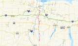
New York State Route 15A (NY 15A) is a north–south state highway
located in the western portion of New York
in the United States. It serves as an easterly alternate route of NY 15
, beginning in the Livingston County
town of Springwater
and ending 35.19 miles (56.63 km) to the north in the Monroe County
city of Rochester
. NY 15A meets U.S. Route 20A
(US 20A) in the hamlet of Hemlock, US 20
and NY 5
in the village of Lima
, and Interstate 390 (I-390) twice in Henrietta
and Brighton
. Its southern and middle sections traverse mostly rural areas, while the northernmost piece in Henrietta, Brighton, and Rochester passes through significantly more developed areas.
From 1927 to the late 1930s, modern NY 15
was part of NY 2. As a result, all of what is now NY 15A was originally designated as New York State Route 2A as part of the 1930 renumbering of state highways in New York. Two parts of the route were sub-standard at the time; however, those sections were rebuilt in the early and mid-1930s. NY 2 was supplanted by an extended US 15
ca. 1939, at which time NY 2A was renumbered to NY 15A to match its parent's new designation.
in the Springwater
hamlet of the same name, located on the east side of a large valley in southeastern Livingston County
. The route heads northward as North Main Street, proceeding along the eastern base of the valley as it passes through the northern half of the community. Outside of the hamlet, NY 15A enters a rural, undeveloped area dominated by dense forests to the east and a low-lying, slightly more open area to the west. As the route approaches the Livingston–Ontario
county line, the lowlands give way to marshes, which in turn lead to Hemlock Lake
at the county line. While in Ontario County, NY 15A follows a more inland route to the east, passing through an isolated forest situated between Hemlock and Canadice Lake
s. After 6 miles (10 km), the highway reenters Livingston County near the northern end of Hemlock Lake.
 Now in the town of Livonia
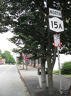
, NY 15A becomes Bald Hill Road as it passes by Hemlock Lake Park, a local park situated at the northeastern tip of the lake. It changes names again just 1.5 miles (2.4 km) later upon entering the hamlet of Hemlock. Here, it becomes Main Street and intersects US 20A
, which forms a concurrency
with NY 15A along the length of Main Street. The concurrency continues through Hemlock and into rural Livonia, where the 2 miles (3.2 km) overlap ends as US 20A turns west towards Buffalo
. NY 15A, meanwhile, heads northward into the town of Lima
as Plank Road. It continues across rural terrain for another 3 miles (5 km) to the village of Lima
, where it becomes Lake Avenue. At the village center, NY 15A crosses over US 20
and NY 5
and changes names to Rochester Street. The route leaves the community and its residential surroundings after 0.75 miles (1.21 km), but retains the Rochester Street name until it reaches the Livingston–Monroe
county line west of Honeoye Falls
.
, NY 15A takes on the name Rush–Lima Road and begins curving to the northwest. It connects to Honeoye Falls twice: first via Main Street at a junction just north of the county line, and later by way of Monroe Street (formerly NY 363) at an intersection 1 miles (1.6 km) to the northwest. Past Monroe Street, the route makes a long, significant turn to the west, following Honeoye Creek
into the town of Rush
and the hamlet of the same name. The highway meets Rush – West Rush Road at an intersection south of the community, at which point NY 15A turns back to the north and crosses over Honeoye Creek. In the process, NY 15A becomes East Henrietta Road, a name the highway retains until its northern end in Rochester
. On the opposite side of the creek, NY 15A intersects NY 251
in the center of Rush.
Outside of Rush, NY 15A takes on a more northeasterly alignment as it passes Rush's town reservoir and enters the town of Henrietta
. The surroundings initially remain as rural as they were in Rush; however, the amount of development along the highway gradually increases as the route approaches and passes over the New York State Thruway
(I-90
). One mile (1.6 km) later, NY 15A intersects NY 253
in a densely populated area west of Rush-Henrietta Senior High School
. The homes continue for another 0.5 mile (0.80467 km) to the Monroe County Fairgrounds (home to The Dome Center
), at which point NY 15A begins to become lined with commercial establishments. The trend temporarily ceases around an interchange with I-390
—where NY 15A curves northwestward—but resumes ahead of a junction with NY 252
, itself a major commercial strip.
North of NY 252, NY 15A passes under the CSX Transportation
-owned West Shore Subdivision
and crosses into Brighton
. Just past the town line, the route connects to Clay and Brighton–Henrietta Town Line Roads by way of a grade-separated intersection 0.25 mile (0.402335 km) north of the railroad overpass. It continues onward, passing along the west side of the sprawling Monroe Community College
campus to another interchange with I-390. NY 15A passes over the Erie Canal
and enters the city of Rochester shortly afterward. Once in the city, the route passes by two large office campuses south of Westfall Road and several blocks of homes north of the street before merging back into NY 15 (Mount Hope Avenue) at a junction east of Strong Memorial Hospital
.
was originally designated as part of NY 4 when the first set of posted routes in New York
were assigned in 1924. The route was renumbered to NY 2 in 1927 to eliminate numerical duplication with the new US 4
in eastern New York. Modern NY 15A, meanwhile, was only partially state-maintained by the mid-1920s. In 1926, only two sections of the route were state-owned: from Monroe Street west of Honeoye Falls
north to Rochester
, and the segment of highway in Livonia
that modern NY 15A shares with US 20A
. In spite of this fact, all of what is now NY 15A was designated as NY 2A, an alternate route of NY 2 between Springwater
and Rochester, in the 1930 renumbering of state highways in New York.
The sub-standard sections of the route between Springwater and Hemlock and from north of Hemlock to Honeoye Falls were improved in stages over the next half-decade, beginning with the piece between the villages of Lima
and Honeoye Falls ca. 1931. The remainder of the Hemlock – Honeoye Falls segment and the entirety of the route south of Hemlock was rebuilt ca. 1934. Ca. 1939, NY 2 was replaced by US 15
, which was extended northward from its previous terminus at the Pennsylvania state line to Rochester. NY 2A was renumbered to NY 15A as a result. NY 15A has not been substantially altered since that time.
State highway
State highway, state road or state route can refer to one of three related concepts, two of them related to a state or provincial government in a country that is divided into states or provinces :#A...
located in the western portion of New York
Western New York
Western New York is the westernmost region of the state of New York. It includes the cities of Buffalo, Rochester, Niagara Falls, the surrounding suburbs, as well as the outlying rural areas of the Great Lakes lowlands, the Genesee Valley, and the Southern Tier. Some historians, scholars and others...
in the United States. It serves as an easterly alternate route of NY 15
New York State Route 15
New York State Route 15 is a north–south state highway located in western New York in the United States. The southern terminus of the route is officially at Interstate 390 exit 3 south of the village of Wayland, although some signage indicating that NY 15 continues south to...
, beginning in the Livingston County
Livingston County, New York
As of the census of 2000, there were 64,328 people, 22,150 households, and 15,349 families residing in the county. The population density was 102 people per square mile . There were 24,023 housing units at an average density of 38 per square mile...
town of Springwater
Springwater, New York
Springwater is a town in Livingston County, New York, United States. The population was 2,322 at the 2000 census.The Town of Springwater is in the southeast part of the county.-History:The first settlers arrived around 1807...
and ending 35.19 miles (56.63 km) to the north in the Monroe County
Monroe County, New York
Monroe County is a county located in the U.S. state of New York. As of the 2010 census, the population was 744,344. It is named after James Monroe, fifth President of the United States of America. Its county seat is the city of Rochester....
city of Rochester
Rochester, New York
Rochester is a city in Monroe County, New York, south of Lake Ontario in the United States. Known as The World's Image Centre, it was also once known as The Flour City, and more recently as The Flower City...
. NY 15A meets U.S. Route 20A
U.S. Route 20A (New York)
U.S. Route 20A is an east–west alternate route of US 20 that extends for across the western portion of New York in the United States. It leaves US 20 in Hamburg, a suburb of Buffalo, and rejoins it in East Bloomfield about five miles west of Canandaigua, the county seat of...
(US 20A) in the hamlet of Hemlock, US 20
U.S. Route 20 in New York
U.S. Route 20 is a part of the U.S. Highway System that runs from Newport, Oregon, to Boston, Massachusetts. In the U.S. state of New York, US 20 extends from the Pennsylvania state line at Ripley to the Massachusetts state line in the Berkshire Mountains. US 20 is the longest...
and NY 5
New York State Route 5
New York State Route 5 is a state highway that extends for across the state of New York in the United States. It begins at the Pennsylvania state line in the Chautauqua County town of Ripley and passes through Buffalo, Syracuse, Utica, Schenectady, and several other smaller cities and...
in the village of Lima
Lima (village), New York
Lima is a village in Livingston County, New York, USA. The population was 2,459 at the 2000 census.The Village of Lima is in the Town of Lima and is nineteen miles south of the city of Rochester, NY.- History :...
, and Interstate 390 (I-390) twice in Henrietta
Henrietta, New York
Henrietta is a town in Monroe County, New York, United States. It is a suburb of Rochester. The population was 42,581 at the 2010 census. Established in 1818, the town is named after Henrietta Laura Pulteney, Countess of Bath, daughter of Sir William Pulteney, 5th Baronet, a major British...
and Brighton
Brighton, Monroe County, New York
Brighton is a town in Monroe County, New York, USA. The population was 36,609 at the 2010 census.-History:The Town of Brighton, located on the southeast border of the city of Rochester, was originally settled approximately 1790, and formally established in 1814—earning it recognition as one...
. Its southern and middle sections traverse mostly rural areas, while the northernmost piece in Henrietta, Brighton, and Rochester passes through significantly more developed areas.
From 1927 to the late 1930s, modern NY 15
New York State Route 15
New York State Route 15 is a north–south state highway located in western New York in the United States. The southern terminus of the route is officially at Interstate 390 exit 3 south of the village of Wayland, although some signage indicating that NY 15 continues south to...
was part of NY 2. As a result, all of what is now NY 15A was originally designated as New York State Route 2A as part of the 1930 renumbering of state highways in New York. Two parts of the route were sub-standard at the time; however, those sections were rebuilt in the early and mid-1930s. NY 2 was supplanted by an extended US 15
U.S. Route 15 in New York
U.S. Route 15 is a part of the U.S. Highway System that runs from Walterboro, South Carolina, to Painted Post, New York. In the U.S. state of New York, US 15 extends through the Southern Tier from the Pennsylvania state line at Lindley north to an interchange with the Southern Tier...
ca. 1939, at which time NY 2A was renumbered to NY 15A to match its parent's new designation.
Livingston and Ontario Counties
NY 15A begins at an intersection with NY 15New York State Route 15
New York State Route 15 is a north–south state highway located in western New York in the United States. The southern terminus of the route is officially at Interstate 390 exit 3 south of the village of Wayland, although some signage indicating that NY 15 continues south to...
in the Springwater
Springwater, New York
Springwater is a town in Livingston County, New York, United States. The population was 2,322 at the 2000 census.The Town of Springwater is in the southeast part of the county.-History:The first settlers arrived around 1807...
hamlet of the same name, located on the east side of a large valley in southeastern Livingston County
Livingston County, New York
As of the census of 2000, there were 64,328 people, 22,150 households, and 15,349 families residing in the county. The population density was 102 people per square mile . There were 24,023 housing units at an average density of 38 per square mile...
. The route heads northward as North Main Street, proceeding along the eastern base of the valley as it passes through the northern half of the community. Outside of the hamlet, NY 15A enters a rural, undeveloped area dominated by dense forests to the east and a low-lying, slightly more open area to the west. As the route approaches the Livingston–Ontario
Ontario County, New York
As of the census of 2000, there were 100,224 people, 38,370 households, and 26,360 families residing in the county. The population density was 156 people per square mile . There were 42,647 housing units at an average density of 66 per square mile...
county line, the lowlands give way to marshes, which in turn lead to Hemlock Lake
Hemlock Lake
Hemlock Lake is one of the minor Finger Lakes. It is mostly located in Livingston County, New York, south of Rochester, with a portion overlapping into Ontario County....
at the county line. While in Ontario County, NY 15A follows a more inland route to the east, passing through an isolated forest situated between Hemlock and Canadice Lake
Canadice Lake
Canadice Lake is one of the minor Finger Lakes of western New York in the USA.Canadice Lake has a shoreline 6.5 miles long and a maximum depth of 95 feet . Because the lake is a water source of Rochester, New York, no houses are permitted on its shore and boats are limited to 16 feet in length...
s. After 6 miles (10 km), the highway reenters Livingston County near the northern end of Hemlock Lake.
Livonia (town), New York
Livonia is a town in Livingston County, New York, United States. As of the 2000 census, the town population was 7,286.The Town of Livonia contains a village, also called Livonia. The town is on the eastern border of the county.-History:...
, NY 15A becomes Bald Hill Road as it passes by Hemlock Lake Park, a local park situated at the northeastern tip of the lake. It changes names again just 1.5 miles (2.4 km) later upon entering the hamlet of Hemlock. Here, it becomes Main Street and intersects US 20A
U.S. Route 20A (New York)
U.S. Route 20A is an east–west alternate route of US 20 that extends for across the western portion of New York in the United States. It leaves US 20 in Hamburg, a suburb of Buffalo, and rejoins it in East Bloomfield about five miles west of Canandaigua, the county seat of...
, which forms a concurrency
Concurrency (road)
A concurrency, overlap, or coincidence in a road network is an instance of one physical road bearing two or more different highway, motorway, or other route numbers...
with NY 15A along the length of Main Street. The concurrency continues through Hemlock and into rural Livonia, where the 2 miles (3.2 km) overlap ends as US 20A turns west towards Buffalo
Buffalo, New York
Buffalo is the second most populous city in the state of New York, after New York City. Located in Western New York on the eastern shores of Lake Erie and at the head of the Niagara River across from Fort Erie, Ontario, Buffalo is the seat of Erie County and the principal city of the...
. NY 15A, meanwhile, heads northward into the town of Lima
Lima (town), New York
Lima is a town in Livingston County, New York, U.S. The population was 4,541 at the 2000 census.The town of Lima is in the northeast part of the county, south of Rochester...
as Plank Road. It continues across rural terrain for another 3 miles (5 km) to the village of Lima
Lima (village), New York
Lima is a village in Livingston County, New York, USA. The population was 2,459 at the 2000 census.The Village of Lima is in the Town of Lima and is nineteen miles south of the city of Rochester, NY.- History :...
, where it becomes Lake Avenue. At the village center, NY 15A crosses over US 20
U.S. Route 20 in New York
U.S. Route 20 is a part of the U.S. Highway System that runs from Newport, Oregon, to Boston, Massachusetts. In the U.S. state of New York, US 20 extends from the Pennsylvania state line at Ripley to the Massachusetts state line in the Berkshire Mountains. US 20 is the longest...
and NY 5
New York State Route 5
New York State Route 5 is a state highway that extends for across the state of New York in the United States. It begins at the Pennsylvania state line in the Chautauqua County town of Ripley and passes through Buffalo, Syracuse, Utica, Schenectady, and several other smaller cities and...
and changes names to Rochester Street. The route leaves the community and its residential surroundings after 0.75 miles (1.21 km), but retains the Rochester Street name until it reaches the Livingston–Monroe
Monroe County, New York
Monroe County is a county located in the U.S. state of New York. As of the 2010 census, the population was 744,344. It is named after James Monroe, fifth President of the United States of America. Its county seat is the city of Rochester....
county line west of Honeoye Falls
Honeoye Falls, New York
Honeoye Falls is a village in Monroe County, New York, United States. The population was 2,595 at the 2000 census. The village includes a small waterfall on Honeoye Creek, which flows through the village and gives it its name....
.
Monroe County
Across the county line in the town of MendonMendon, New York
Mendon is a town in Monroe County, New York, United States, and an affluent suburb of Rochester, New York. The population was 9,152 at the 2010 census.The Town of Mendon is on the south border of the county...
, NY 15A takes on the name Rush–Lima Road and begins curving to the northwest. It connects to Honeoye Falls twice: first via Main Street at a junction just north of the county line, and later by way of Monroe Street (formerly NY 363) at an intersection 1 miles (1.6 km) to the northwest. Past Monroe Street, the route makes a long, significant turn to the west, following Honeoye Creek
Honeoye Creek
Honeoye Creek is a tributary of the Genesee River in western New York in the United States.Honeoye Creek emerges from the north end of Honeoye Lake, one of the Finger Lakes, in Richmond, Ontario County...
into the town of Rush
Rush, New York
Rush is a town in Monroe County, New York, United States. The population was 3,478 at the 2010 census.The Town of Rush is a suburb of Rochester located in the southwest part of the county.-Geography:...
and the hamlet of the same name. The highway meets Rush – West Rush Road at an intersection south of the community, at which point NY 15A turns back to the north and crosses over Honeoye Creek. In the process, NY 15A becomes East Henrietta Road, a name the highway retains until its northern end in Rochester
Rochester, New York
Rochester is a city in Monroe County, New York, south of Lake Ontario in the United States. Known as The World's Image Centre, it was also once known as The Flour City, and more recently as The Flower City...
. On the opposite side of the creek, NY 15A intersects NY 251
New York State Route 251
New York State Route 251 is an east–west state highway in western New York in the United States. It extends for from NY 383 in Scottsville, Monroe County, to NY 96 in the town of Victor, Ontario County...
in the center of Rush.
Outside of Rush, NY 15A takes on a more northeasterly alignment as it passes Rush's town reservoir and enters the town of Henrietta
Henrietta, New York
Henrietta is a town in Monroe County, New York, United States. It is a suburb of Rochester. The population was 42,581 at the 2010 census. Established in 1818, the town is named after Henrietta Laura Pulteney, Countess of Bath, daughter of Sir William Pulteney, 5th Baronet, a major British...
. The surroundings initially remain as rural as they were in Rush; however, the amount of development along the highway gradually increases as the route approaches and passes over the New York State Thruway
New York State Thruway
The New York State Thruway is a system of limited-access highways located within the state of New York in the United States. The system, known officially as the Governor Thomas E. Dewey Thruway for former New York Governor Thomas E. Dewey, is operated by the New York State Thruway Authority and...
(I-90
Interstate 90 in New York
Interstate 90 is a part of the Interstate Highway System that runs from Seattle, Washington, to Boston, Massachusetts. In the U.S. state of New York, I-90 extends from the Pennsylvania state line at Ripley to the Massachusetts state line at Canaan...
). One mile (1.6 km) later, NY 15A intersects NY 253
New York State Route 253
New York State Route 253 is a long east–west state highway in Monroe County, New York, United States. The western terminus of the route is at NY 383 in the village of Scottsville. Its eastern terminus is at NY 65 in the town of Pittsford...
in a densely populated area west of Rush-Henrietta Senior High School
Rush-Henrietta Senior High School
Rush-Henrietta Senior High School - James E. Sperry Building, located in Henrietta, New York, also referred to as Rush-Henrietta Senior High School, R-H and Sperry High School, is the only high school in the Rush-Henrietta Central School District...
. The homes continue for another 0.5 mile (0.80467 km) to the Monroe County Fairgrounds (home to The Dome Center
The Dome Center
The Dome Center is a fair and convention complex located in Henrietta, New York, USA. It is the site of the annual Monroe County Fair and comprises the following:...
), at which point NY 15A begins to become lined with commercial establishments. The trend temporarily ceases around an interchange with I-390
Interstate 390
Interstate 390 is a north–south auxiliary Interstate Highway located entirely within New York in the United States. The southern terminus of the route is at the Southern Tier Expressway in the town of Avoca. Its northern terminus is at I-490 in Rochester...
—where NY 15A curves northwestward—but resumes ahead of a junction with NY 252
New York State Route 252
New York State Route 252 is an east–west state highway south of Rochester in Monroe County, New York, in the United States. The western terminus of the route is at an intersection with NY 33A in Chili and the eastern terminus is at a junction with NY 64 and NY 96 in the village...
, itself a major commercial strip.
North of NY 252, NY 15A passes under the CSX Transportation
CSX Transportation
CSX Transportation operates a Class I railroad in the United States known as the CSX Railroad. It is the main subsidiary of the CSX Corporation. The company is headquartered in Jacksonville, Florida, and owns approximately 21,000 route miles...
-owned West Shore Subdivision
West Shore Subdivision
The West Shore Subdivision is a railroad line owned by CSX Transportation in the U.S. state of New York. The line runs from Fairport, CP-359, west to North Chili, CP-382, along a former New York Central Railroad line. Both of its ends are at the Rochester Subdivision; it provides a southern bypass...
and crosses into Brighton
Brighton, Monroe County, New York
Brighton is a town in Monroe County, New York, USA. The population was 36,609 at the 2010 census.-History:The Town of Brighton, located on the southeast border of the city of Rochester, was originally settled approximately 1790, and formally established in 1814—earning it recognition as one...
. Just past the town line, the route connects to Clay and Brighton–Henrietta Town Line Roads by way of a grade-separated intersection 0.25 mile (0.402335 km) north of the railroad overpass. It continues onward, passing along the west side of the sprawling Monroe Community College
Monroe Community College
Monroe Community College is a two-year college of the State University of New York, located in Monroe County, New York. The college has two campuses, one in the town of Brighton and another, the Damon City Campus, in the City of Rochester...
campus to another interchange with I-390. NY 15A passes over the Erie Canal
Erie Canal
The Erie Canal is a waterway in New York that runs about from Albany, New York, on the Hudson River to Buffalo, New York, at Lake Erie, completing a navigable water route from the Atlantic Ocean to the Great Lakes. The canal contains 36 locks and encompasses a total elevation differential of...
and enters the city of Rochester shortly afterward. Once in the city, the route passes by two large office campuses south of Westfall Road and several blocks of homes north of the street before merging back into NY 15 (Mount Hope Avenue) at a junction east of Strong Memorial Hospital
Strong Memorial Hospital
Strong Memorial Hospital is a 739-bed medical facility, part of the University of Rochester Medical Center complex , in Rochester, New York. Opened in 1926, is a major provider of both in-patient and out-patient medical services....
.
History
What is now NY 15New York State Route 15
New York State Route 15 is a north–south state highway located in western New York in the United States. The southern terminus of the route is officially at Interstate 390 exit 3 south of the village of Wayland, although some signage indicating that NY 15 continues south to...
was originally designated as part of NY 4 when the first set of posted routes in New York
New York
New York is a state in the Northeastern region of the United States. It is the nation's third most populous state. New York is bordered by New Jersey and Pennsylvania to the south, and by Connecticut, Massachusetts and Vermont to the east...
were assigned in 1924. The route was renumbered to NY 2 in 1927 to eliminate numerical duplication with the new US 4
U.S. Route 4 in New York
U.S. Route 4 is a part of the U.S. Highway System that runs from East Greenbush, New York, to Portsmouth, New Hampshire. In the U.S. state of New York, US 4 extends from an intersection with US 9 and US 20 in East Greenbush to the Vermont state line northeast of Whitehall...
in eastern New York. Modern NY 15A, meanwhile, was only partially state-maintained by the mid-1920s. In 1926, only two sections of the route were state-owned: from Monroe Street west of Honeoye Falls
Honeoye Falls, New York
Honeoye Falls is a village in Monroe County, New York, United States. The population was 2,595 at the 2000 census. The village includes a small waterfall on Honeoye Creek, which flows through the village and gives it its name....
north to Rochester
Rochester, New York
Rochester is a city in Monroe County, New York, south of Lake Ontario in the United States. Known as The World's Image Centre, it was also once known as The Flour City, and more recently as The Flower City...
, and the segment of highway in Livonia
Livonia (town), New York
Livonia is a town in Livingston County, New York, United States. As of the 2000 census, the town population was 7,286.The Town of Livonia contains a village, also called Livonia. The town is on the eastern border of the county.-History:...
that modern NY 15A shares with US 20A
U.S. Route 20A (New York)
U.S. Route 20A is an east–west alternate route of US 20 that extends for across the western portion of New York in the United States. It leaves US 20 in Hamburg, a suburb of Buffalo, and rejoins it in East Bloomfield about five miles west of Canandaigua, the county seat of...
. In spite of this fact, all of what is now NY 15A was designated as NY 2A, an alternate route of NY 2 between Springwater
Springwater, New York
Springwater is a town in Livingston County, New York, United States. The population was 2,322 at the 2000 census.The Town of Springwater is in the southeast part of the county.-History:The first settlers arrived around 1807...
and Rochester, in the 1930 renumbering of state highways in New York.
The sub-standard sections of the route between Springwater and Hemlock and from north of Hemlock to Honeoye Falls were improved in stages over the next half-decade, beginning with the piece between the villages of Lima
Lima (village), New York
Lima is a village in Livingston County, New York, USA. The population was 2,459 at the 2000 census.The Village of Lima is in the Town of Lima and is nineteen miles south of the city of Rochester, NY.- History :...
and Honeoye Falls ca. 1931. The remainder of the Hemlock – Honeoye Falls segment and the entirety of the route south of Hemlock was rebuilt ca. 1934. Ca. 1939, NY 2 was replaced by US 15
U.S. Route 15 in New York
U.S. Route 15 is a part of the U.S. Highway System that runs from Walterboro, South Carolina, to Painted Post, New York. In the U.S. state of New York, US 15 extends through the Southern Tier from the Pennsylvania state line at Lindley north to an interchange with the Southern Tier...
, which was extended northward from its previous terminus at the Pennsylvania state line to Rochester. NY 2A was renumbered to NY 15A as a result. NY 15A has not been substantially altered since that time.