

New Hampshire Route 112
Encyclopedia
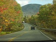
New Hampshire Route 112 (abbreviated NH 112) is a 56.39 miles (90.8 km) long east–west state highway
in northern New Hampshire
. The highway winds across the state, connecting Bath
to Conway
via the scenic and mountainous area of the White Mountain National Forest
. Part of this highway, which runs through the White Mountains
, is known as the Kancamagus Highway. This highway is known for its views of autumn foliage and is a popular drive in September and October for so-called leaf peeping
tourism.
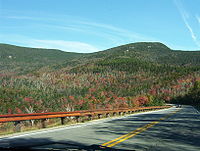
The Kancamagus Highway is a 26.5 miles (42.6 km)-long two-lane road that runs east and west through the White Mountains and constitutes the eastern half of New Hampshire Route 112. It has been designated a National Scenic Byway
by the United States Department of Transportation
under the name Kancamagus Scenic Byway.
The highway stays open all winter, although it occasionally closes for short periods while crews clear heavy snows. Its only major intersection, Bear Notch Road, which connects with the town of Bartlett
, is closed all winter.
Following Hurricane Irene
in August 2011, two sections of Route 112 were closed, pending repair work and evaluation of damage. The Kancamagus Highway was closed from the Sabbaday Falls picnic area across Kancamagus Pass to the Discovery Trail parking area in the eastern part of Lincoln. A section of the western portion of Route 112 along the Wild Ammonoosuc River
was closed; as of September 6, 2011, a single lane of the western section had been reopened.
 The eastern terminus of NH 112 and the Kancamagus Highway is in the town of Conway at New Hampshire Route 16
(the White Mountain Highway) and New Hampshire Route 113
. Traveling almost entirely within the White Mountain National Forest
, the highway follows the Swift River
valley west and climbs to the summit of Kancamagus Pass at an elevation of 2855 feet (870.2 m), then descends to the valley of the East Branch of the Pemigewasset River
, which it follows to Lincoln
, the western terminus of the Kancamagus Highway. NH 112 continues west, crossing Interstate 93
and U.S. Route 3
in North Woodstock
, then climbing through Kinsman Notch
and descending northwest along the Wild Ammonoosuc River
to its western terminus, in the town of Bath at U.S. Route 302
and New Hampshire Route 10
, about 4 miles (6.4 km) from the Vermont
border.
 The Kancamagus Highway opened in 1959 after two dead-end stretches of road were linked, creating a connection between Interstate 93 in Lincoln and New Hampshire Route 16 in Conway.
The highway is named after Kancamagus , third and final Sagamore of the Penacook Confederacy
of Native American
tribes. Nephew of Wonalancet
and grandson of Passaconaway
, Kancamagus ruled what is now southern New Hampshire. Wearied of fighting English settlers, he made the decision in 1691 to move north into upper New Hampshire and what is now Quebec
, Canada
.
State highway
State highway, state road or state route can refer to one of three related concepts, two of them related to a state or provincial government in a country that is divided into states or provinces :#A...
in northern New Hampshire
New Hampshire
New Hampshire is a state in the New England region of the northeastern United States of America. The state was named after the southern English county of Hampshire. It is bordered by Massachusetts to the south, Vermont to the west, Maine and the Atlantic Ocean to the east, and the Canadian...
. The highway winds across the state, connecting Bath
Bath, New Hampshire
Bath is a town in Grafton County, New Hampshire, United States. The population was 1,077 at the 2010 census. Now a tourist destination and bedroom community for Littleton, the town is noted for its historic architecture, including the Brick Store and three covered bridges...
to Conway
Conway, New Hampshire
Conway is a town, the largest in Carroll County, New Hampshire, United States. The population was 10,115 at the 2010 census. Parts of the White Mountain National Forest are in the west and north. Cathedral Ledge and Echo Lake State Park are in the west...
via the scenic and mountainous area of the White Mountain National Forest
White Mountain National Forest
The White Mountain National Forest is a federally-managed forest contained within the White Mountains in the northeastern United States. It was established in 1918 as a result of the Weeks Act of 1911; federal acquisition of land had already begun in 1914. It has a total area of...
. Part of this highway, which runs through the White Mountains
White Mountains (New Hampshire)
The White Mountains are a mountain range covering about a quarter of the state of New Hampshire and a small portion of western Maine in the United States. Part of the Appalachian Mountains, they are considered the most rugged mountains in New England...
, is known as the Kancamagus Highway. This highway is known for its views of autumn foliage and is a popular drive in September and October for so-called leaf peeping
Leaf peeping
Leaf peeping is an informal term, commonly used in the United States, for people who travel to view and photograph the fall foliage in areas where foliage changes colors, particularly New England.The origin of the term "leaf peeping" is not well known....
tourism.
The Kancamagus Highway is a 26.5 miles (42.6 km)-long two-lane road that runs east and west through the White Mountains and constitutes the eastern half of New Hampshire Route 112. It has been designated a National Scenic Byway
National Scenic Byway
A National Scenic Byway is a road recognized by the United States Department of Transportation for its archeological, cultural, historic, natural, recreational, and/or scenic qualities. The program was established by Congress in 1991 to preserve and protect the nation's scenic but often...
by the United States Department of Transportation
United States Department of Transportation
The United States Department of Transportation is a federal Cabinet department of the United States government concerned with transportation. It was established by an act of Congress on October 15, 1966, and began operation on April 1, 1967...
under the name Kancamagus Scenic Byway.
The highway stays open all winter, although it occasionally closes for short periods while crews clear heavy snows. Its only major intersection, Bear Notch Road, which connects with the town of Bartlett
Bartlett, New Hampshire
Bartlett is a town in Carroll County, New Hampshire, United States. The population was 2,788 at the 2010 census. Bartlett includes the villages of Glen, Lower Bartlett and Intervale. It is set in the White Mountains, surrounded by the White Mountain National Forest...
, is closed all winter.
Following Hurricane Irene
Hurricane Irene (2011)
Hurricane Irene was a large and powerful Atlantic hurricane that left extensive flood and wind damage along its path through the Caribbean, the United States East Coast and as far north as Atlantic Canada in 2011...
in August 2011, two sections of Route 112 were closed, pending repair work and evaluation of damage. The Kancamagus Highway was closed from the Sabbaday Falls picnic area across Kancamagus Pass to the Discovery Trail parking area in the eastern part of Lincoln. A section of the western portion of Route 112 along the Wild Ammonoosuc River
Wild Ammonoosuc River
The Wild Ammonoosuc River is a tributary of the Ammonoosuc River, about long, in northwestern New Hampshire in the United States. Via the Ammonoosuc River, it is part of the watershed of the Connecticut River, which flows to Long Island Sound....
was closed; as of September 6, 2011, a single lane of the western section had been reopened.
Route description
New Hampshire Route 16
New Hampshire Route 16 is a long north–south highway in the U.S. state of New Hampshire. Much of its length is close to the border with Maine. NH 16 is the main route from the Seacoast region north to the Lakes Region and the White Mountains. The section from Portsmouth to Milton is a...
(the White Mountain Highway) and New Hampshire Route 113
New Hampshire Route 113
New Hampshire Route 113 is a long east–west state highway in east-central New Hampshire. Route 113 begins in the Lakes Region at an intersection with U.S. Route 3 and New Hampshire Route 25 in Holderness, and stretches eastward across the central part of the state, ending at an intersection with...
. Traveling almost entirely within the White Mountain National Forest
White Mountain National Forest
The White Mountain National Forest is a federally-managed forest contained within the White Mountains in the northeastern United States. It was established in 1918 as a result of the Weeks Act of 1911; federal acquisition of land had already begun in 1914. It has a total area of...
, the highway follows the Swift River
Swift River (Saco River)
The Swift River is a river in the White Mountains of New Hampshire in the United States. It is a tributary of the Saco River, which flows to the Atlantic Ocean in Maine....
valley west and climbs to the summit of Kancamagus Pass at an elevation of 2855 feet (870.2 m), then descends to the valley of the East Branch of the Pemigewasset River
East Branch Pemigewasset River
The East Branch of the Pemigewasset River is a river located in the White Mountains of New Hampshire in the United States. It is a tributary of the Pemigewasset River, part of the Merrimack River watershed....
, which it follows to Lincoln
Lincoln, New Hampshire
Lincoln is a town in Grafton County, New Hampshire, United States. It is the second-largest town by area in New Hampshire. The population was 1,662 at the 2010 census. The town is home to the New Hampshire Highland Games and to a portion of Franconia Notch State Park. Set in the White Mountains,...
, the western terminus of the Kancamagus Highway. NH 112 continues west, crossing Interstate 93
Interstate 93
Interstate 93 is an Interstate Highway in the New England section of the United States. Its southern terminus is in Canton, Massachusetts, in the Boston metropolitan area, at Interstate 95; its northern terminus is near St. Johnsbury, Vermont, at Interstate 91...
and U.S. Route 3
U.S. Route 3
U.S. Route 3 is a north–south United States highway that runs from its southern terminus in Cambridge, Massachusetts through New Hampshire to its terminus near Third Connecticut Lake at the Canadian border, where the road continues north as Quebec Route 257.In New Hampshire parts of US 3 are...
in North Woodstock
North Woodstock, New Hampshire
North Woodstock is a census-designated place in the town of Woodstock in Grafton County, New Hampshire. It had a population of 528 at the 2010 census....
, then climbing through Kinsman Notch
Kinsman Notch
Kinsman Notch is a mountain pass located in the White Mountains of New Hampshire, United States. It is the westernmost of the major notches through the White Mountains...
and descending northwest along the Wild Ammonoosuc River
Wild Ammonoosuc River
The Wild Ammonoosuc River is a tributary of the Ammonoosuc River, about long, in northwestern New Hampshire in the United States. Via the Ammonoosuc River, it is part of the watershed of the Connecticut River, which flows to Long Island Sound....
to its western terminus, in the town of Bath at U.S. Route 302
U.S. Route 302
U.S. Route 302 is a spur of U.S. Route 2. It currently runs 171 miles north from Portland, Maine, at U.S. Route 1, to Montpelier, Vermont, at US 2...
and New Hampshire Route 10
New Hampshire Route 10
New Hampshire Route 10 is a north–south state highway in the U.S. state of New Hampshire. Its southern terminus is at the Massachusetts state line in the town of Winchester. In Massachusetts the highway becomes Massachusetts Route 10. Total length of the highway is .-Route description:NH 10...
, about 4 miles (6.4 km) from the Vermont
Vermont
Vermont is a state in the New England region of the northeastern United States of America. The state ranks 43rd in land area, , and 45th in total area. Its population according to the 2010 census, 630,337, is the second smallest in the country, larger only than Wyoming. It is the only New England...
border.
History
The highway is named after Kancamagus , third and final Sagamore of the Penacook Confederacy
Pennacook
The Pennacook, also known by the names Merrimack and Pawtucket, were a North American people that primarily inhabited the Merrimack River valley of present-day New Hampshire and Massachusetts, as well as portions of southern Maine...
of Native American
Native Americans in the United States
Native Americans in the United States are the indigenous peoples in North America within the boundaries of the present-day continental United States, parts of Alaska, and the island state of Hawaii. They are composed of numerous, distinct tribes, states, and ethnic groups, many of which survive as...
tribes. Nephew of Wonalancet
Wonalancet
Wonalancet — also spelled Wannalancet and Wannalancit and probably Wanaloset and Wanalosett — was a sachem or sagamore of the Penacook Indians. He was the son of Passaconaway.-Biography:...
and grandson of Passaconaway
Passaconaway
Passaconaway, a name which translates to "Child of the Bear", was a chieftain in the Pennacook tribe.-Life:One of the key native figures in the colonial history of New Hampshire, Passaconaway was believed to have been born between 1550 and 1570, and is said to have died in 1679...
, Kancamagus ruled what is now southern New Hampshire. Wearied of fighting English settlers, he made the decision in 1691 to move north into upper New Hampshire and what is now Quebec
Quebec
Quebec or is a province in east-central Canada. It is the only Canadian province with a predominantly French-speaking population and the only one whose sole official language is French at the provincial level....
, Canada
Canada
Canada is a North American country consisting of ten provinces and three territories. Located in the northern part of the continent, it extends from the Atlantic Ocean in the east to the Pacific Ocean in the west, and northward into the Arctic Ocean...
.