
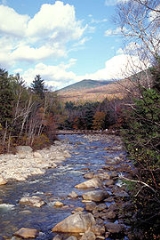
East Branch Pemigewasset River
Encyclopedia

River
A river is a natural watercourse, usually freshwater, flowing towards an ocean, a lake, a sea, or another river. In a few cases, a river simply flows into the ground or dries up completely before reaching another body of water. Small rivers may also be called by several other names, including...
located in the White Mountains
White Mountains (New Hampshire)
The White Mountains are a mountain range covering about a quarter of the state of New Hampshire and a small portion of western Maine in the United States. Part of the Appalachian Mountains, they are considered the most rugged mountains in New England...
of New Hampshire
New Hampshire
New Hampshire is a state in the New England region of the northeastern United States of America. The state was named after the southern English county of Hampshire. It is bordered by Massachusetts to the south, Vermont to the west, Maine and the Atlantic Ocean to the east, and the Canadian...
in the United States
United States
The United States of America is a federal constitutional republic comprising fifty states and a federal district...
. It is a tributary
Tributary
A tributary or affluent is a stream or river that flows into a main stem river or a lake. A tributary does not flow directly into a sea or ocean...
of the Pemigewasset River
Pemigewasset River
The Pemigewasset River , known locally as "The Pemi", is a river in the state of New Hampshire, the United States. It is in length and drains approximately...
, part of the Merrimack River
Merrimack River
The Merrimack River is a river in the northeastern United States. It rises at the confluence of the Pemigewasset and Winnipesaukee rivers in Franklin, New Hampshire, flows southward into Massachusetts, and then flows northeast until it empties into the Atlantic Ocean at Newburyport...
watershed
Drainage basin
A drainage basin is an extent or an area of land where surface water from rain and melting snow or ice converges to a single point, usually the exit of the basin, where the waters join another waterbody, such as a river, lake, reservoir, estuary, wetland, sea, or ocean...
.
The East Branch is a longer and larger river than the river that it flows into, but it is named a branch of the main stem because its source lies deep in the Pemigewasset Wilderness
Pemigewasset Wilderness
The Pemigewasset Wilderness is a federally-designated Wilderness Area in the heart of New Hampshire's White Mountains. It is a part of the White Mountain National Forest....
of the White Mountains, while the main Pemigewasset River flows directly from Franconia Notch
Franconia Notch
Franconia Notch is a major mountain pass through the White Mountains of New Hampshire. Dominated by Cannon Mountain, it lies principally within Franconia Notch State Park and is traversed by the Franconia Notch Parkway Franconia Notch (el. 1950 ft. / 590 m.) is a major mountain pass through...
, a major pass
Mountain pass
A mountain pass is a route through a mountain range or over a ridge. If following the lowest possible route, a pass is locally the highest point on that route...
through the mountains. The East Branch begins in the locality known as Stillwater, in a wide valley north of Mount Carrigain
Mount Carrigain
Mount Carrigain is a mountain located in Grafton County, New Hampshire. The mountain is named after Phillip Carrigain, NH Secretary of State , and is on the south side of the Pemigewasset Wilderness, the source of the East Branch of the Pemigewasset River in the heart of the White Mountains,...
and Mount Hancock
Mount Hancock
Hills and mountains named Hancock, probably named after John Hancock , one of the Founding Fathers of the United States:* Hancock Butte * Hancock Hill * Hancock Hill * Hancock Hill...
, where several large brooks converge. The river flows west and southwest through the heart of the Pemigewasset Wilderness, picking up tributaries such as the North Fork
North Fork Pemigewasset River
The North Fork of the East Branch of the Pemigewasset River is a river located in the White Mountains of New Hampshire in the United States. It is a tributary of the East Branch of the Pemigewasset River, part of the Merrimack River watershed....
of the Pemigewasset and Franconia Branch before reaching, at the Lincoln Woods Visitor Center, the Kancamagus Highway stretch of New Hampshire Route 112
New Hampshire Route 112
New Hampshire Route 112 is a long east–west state highway in northern New Hampshire. The highway winds across the state, connecting Bath to Conway via the scenic and mountainous area of the White Mountain National Forest. Part of this highway, which runs through the White Mountains, is known as...
.
Now into developed areas, the East Branch meets the Hancock Branch coming from the southeast and flows past the Loon Mountain
Loon Mountain
Loon Mountain is a mountain in Lincoln, New Hampshire, in Grafton County. It is in the White Mountain National Forest.The mountain is known for Loon Mountain Ski Resort, which, like most New England mountain resorts, has expanded into an all-season recreation area.-External links:* - Official site*...
ski area to the village of Lincoln, New Hampshire
Lincoln, New Hampshire
Lincoln is a town in Grafton County, New Hampshire, United States. It is the second-largest town by area in New Hampshire. The population was 1,662 at the 2010 census. The town is home to the New Hampshire Highland Games and to a portion of Franconia Notch State Park. Set in the White Mountains,...
. The river crosses into Woodstock
Woodstock, New Hampshire
Woodstock is a town in Grafton County, New Hampshire, United States. The population was 1,374 at the 2010 census. Woodstock includes the village of North Woodstock, the commercial center. Its extensive land area is largely forested, and includes the Hubbard Brook Experimental Forest. Parts of the...
and ends at the Pemigewasset River just downstream from the Interstate 93
Interstate 93
Interstate 93 is an Interstate Highway in the New England section of the United States. Its southern terminus is in Canton, Massachusetts, in the Boston metropolitan area, at Interstate 95; its northern terminus is near St. Johnsbury, Vermont, at Interstate 91...
highway bridges.