

Neighborhoods of New York City
Encyclopedia
New York City
New York is the most populous city in the United States and the center of the New York Metropolitan Area, one of the most populous metropolitan areas in the world. New York exerts a significant impact upon global commerce, finance, media, art, fashion, research, technology, education, and...
.
Boroughs
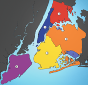
New York City is split up into five boroughs, which are The BronxThe Bronx
The Bronx is the northernmost of the five boroughs of New York City. It is also known as Bronx County, the last of the 62 counties of New York State to be incorporated...
, Brooklyn
Brooklyn
Brooklyn is the most populous of New York City's five boroughs, with nearly 2.6 million residents, and the second-largest in area. Since 1896, Brooklyn has had the same boundaries as Kings County, which is now the most populous county in New York State and the second-most densely populated...
, Manhattan
Manhattan
Manhattan is the oldest and the most densely populated of the five boroughs of New York City. Located primarily on the island of Manhattan at the mouth of the Hudson River, the boundaries of the borough are identical to those of New York County, an original county of the state of New York...
, Queens
Queens
Queens is the easternmost of the five boroughs of New York City. The largest borough in area and the second-largest in population, it is coextensive with Queens County, an administrative division of New York state, in the United States....
, and Staten Island
Staten Island
Staten Island is a borough of New York City, New York, United States, located in the southwest part of the city. Staten Island is separated from New Jersey by the Arthur Kill and the Kill Van Kull, and from the rest of New York by New York Bay...
.
Community areas
| Community Board(CB) | Areakm² | Pop.Census2000 | Pop./km² | Neighborhoods |
|---|---|---|---|---|
| Bronx CB 1 | 7.17 | 82,159 | 11,459 | Mott Haven Mott Haven, Bronx Mott Haven is a primarily residential neighborhood in the Southwestern section of The Bronx in New York City. Zip codes include 10451, 10454, and 10455. The neighborhood is part of Bronx Community Board 1... , Port Morris Port Morris, Bronx Port Morris is a neighborhood in the southwest Bronx, New York City. It is a heavily industrial neighborhood. Its boundaries are the Major Deegan Expressway and Bruckner Expressway to the north, East 149th Street to the east, the East River to the southeast, the Bronx Kill south, and the Harlem... , Melrose Melrose, Bronx Melrose is primarily a residential neighborhood geographically located in the SouthWestern section of the borough of The Bronx in New York City. The neighborhood is part of Bronx Community Board 1. Its boundaries, starting from the North and moving clockwise are: East 161st Street to the North,... |
| Bronx CB 2 | 5.54 | 46,824 | 8,452 | Longwood Longwood, Bronx Longwood is a low income residential neighborhood geographically located in the southwest Bronx, New York City. The neighborhood is part of Bronx Community Board 2. Its boundaries, starting from the north and moving clockwise are: East 167th Street to the north, the Bronx River & the Bruckner... , Hunts Point Hunts Point, Bronx Hunts Point is a low-income neighborhood located on a peninsula in the South Bronx in New York City. It is the location of one of the largest food distribution facilities in the world. The neighborhood is part of Bronx Community Board 2. Its boundaries are the Bruckner Expressway to the west and... |
| Bronx CB 3 | 4.07 | 68,574 | 16,849 | Claremont, Crotona Park, Concourse Village, Morrisania |
| Bronx CB 4 | 5.28 | 139,563 | 26,432 | Concourse, High Bridge |
| Bronx CB 5 | 3.55 | 128,313 | 36,145 | University Heights University Heights, Bronx University Heights is a residential neighborhood of the West Bronx in New York City. The neighborhood is part of Bronx Community Board 5 and Bronx Community Board 7. Its boundaries, starting from the north and moving clockwise, are: West 190th Street to the north, Jerome Avenue to the east, West... , Morris Heights Morris Heights, Bronx Morris Heights is a low income residential neighborhood located in the west Bronx. The neighborhood is part of Bronx Community Board 5. Its boundaries, starting from the north and moving clockwise are: West Burnside Avenue to the north, Jerome Avenue to the east, the Cross-Bronx Expressway to the... , Mount Hope, Fordham Fordham, Bronx Fordham is a neighborhood of New York City, United States, located in the West Bronx. The neighborhood is part of Bronx Community Board 5. It is bordered by Fordham Road to the north, Webster Avenue to the east, East 183rd Street to the south, and Jerome Avenue to the west... |
| Bronx CB 6 | 4.01 | 75,688 | 18,875 | Belmont, Bathgate, West Farms, East Tremont |
| Bronx CB 7 | 4.84 | 141,411 | 29,217 | Norwood Norwood, Bronx Norwood is a working class residential neighborhood in the northwest Bronx, New York City. As of the census of 2000, the seven census tracts that make up the neighborhood have a population of 40,748... , University Heights University Heights, Bronx University Heights is a residential neighborhood of the West Bronx in New York City. The neighborhood is part of Bronx Community Board 5 and Bronx Community Board 7. Its boundaries, starting from the north and moving clockwise, are: West 190th Street to the north, Jerome Avenue to the east, West... , Bedford Park Bedford Park, Bronx Bedford Park is a residential neighborhood in the northwest Bronx between the New York Botanical Garden and Lehman College. Its boundaries, starting from the north and moving clockwise are: Mosholu Parkway to the north, Webster Avenue to the east, East 198th Street to the south, and Jerome Avenue... |
| Bronx CB 8 | 8.83 | 101,332 | 11,476 | Riverdale, Spuyten Duyvil, Van Cortlandt Village, Kingsbridge, Kingsbridge Heights, Fieldston, Marble Hill |
| Bronx CB 9 | 12.41 | 167,859 | 13,526 | Parkchester, Unionport, Soundview, Castle Hill, Bruckner, Harding Park, Bronx River, Clason Point |
| Bronx CB 10 | 16.76 | 115,948 | 6,918 | Co-op City, City Island, Throggs Neck, Westchester Square, Pelham Bay, Locust Point, Silver Beach |
| Bronx CB 11 | 9.32 | 110,706 | 11,878 | Morris Park, Pelham Parkway, Pelham Gardens, Allerton, Bronxdale, Laconia, Van Nest |
| Bronx CB 12 | 14.56 | 149,077 | 10,239 | Edenwald, Wakefield, Williamsbridge, Woodlawn, Fish Bay, Eastchester, Olinville, Baychester |
| Brooklyn CB 1 | 12.82 | 160,338 | 12,507 | Williamsburg, Greenpoint |
| Brooklyn CB 2 | 7.72 | 98,620 | 12,775 | Brooklyn Heights, DUMBO, Vinegar Hill, Fulton Mall, Boerum Hill Boerum Hill Boerum Hill is a small neighborhood in the northwestern portion of the New York City borough of Brooklyn that occupies 36 blocks bounded by State Street to the north, 4th Avenue to the east, Smith Street to the west, and Warren Street to the south. Commercial strips line Smith Street and Atlantic... , Fort Greene, Brooklyn Navy Yard Brooklyn Navy Yard The United States Navy Yard, New York–better known as the Brooklyn Navy Yard or the New York Naval Shipyard –was an American shipyard located in Brooklyn, northeast of the Battery on the East River in Wallabout Basin, a semicircular bend of the river across from Corlear's Hook in Manhattan... , Fulton Ferry, Clinton Hill |
| Brooklyn CB 3 | 7.67 | 143,867 | 18,757 | Bedford-Stuyvesant, Stuyvesant Heights, Ocean Hill |
| Brooklyn CB 4 | 5.31 | 104,358 | 19,653 | Bushwick |
| Brooklyn CB 5 | 14.61 | 173,198 | 11,855 | East New York, Cypress Hills, Highland Park, New Lots, City Line, Starrett City |
| Brooklyn CB 6 | 9.01 | 104,054 | 11,549 | Red Hook, Carroll Gardens, Park Slope, Gowanus, Cobble Hill |
| Brooklyn CB 7 | 10.96 | 120,063 | 10,955 | Sunset Park, Windsor Terrace, Greenwood Heights |
| Brooklyn CB 8 | 4.25 | 96,076 | 22,606 | Crown Heights Crown Heights, Brooklyn Crown Heights is a neighborhood in the central portion of the New York City borough of Brooklyn. The main thoroughfare through this neighborhood is Eastern Parkway, a tree-lined boulevard designed by Frederick Law Olmsted extending two miles east-west.Originally, the area was known as Crow Hill.... , Prospect Heights, Weeksville |
| Brooklyn CB 9 | 4.07 | 104,014 | 25,556 | Crown Heights, Prospect Lefferts Gardens, Wingate |
| Brooklyn CB 10 | 10.57 | 122,542 | 11,593 | Bay Ridge, Dyker Heights, Fort Hamilton |
| Brooklyn CB 11 | 10.18 | 172,129 | 16,909 | Bath Beach, Gravesend, Mapleton, Bensonhurst |
| Brooklyn CB 12 | 9.32 | 185,046 | 19,855 | Borough Park, Kensington, Ocean Parkway, Midwood |
| Brooklyn CB 13 | 8.88 | 106,120 | 11,950 | Coney Island Coney Island Coney Island is a peninsula and beach on the Atlantic Ocean in southern Brooklyn, New York, United States. The site was formerly an outer barrier island, but became partially connected to the mainland by landfill.... , Brighton Beach Brighton Beach Brighton Beach is an oceanside neighborhood in the New York City borough of Brooklyn. As of 2000, it has a population of 75,692 with a total of 31,228 households.-Location:... , Bensonhurst, Gravesend, Seagate |
| Brooklyn CB 14 | 7.61 | 168,806 | 22,182 | Flatbush Flatbush, Brooklyn Flatbush is a community of the Borough of Brooklyn, a part of New York City, consisting of several neighborhoods.The name Flatbush is an Anglicization of the Dutch language Vlacke bos .... , Midwood, Kensington, Ocean Parkway |
| Brooklyn CB 15 | 12.82 | 160,319 | 12,505 | Sheepshead Bay, Manhattan Beach, Kings Bay, Gerritsen Beach, Kings Highway, East Gravesend, Madison, Homecrest, Plum Beach |
| Brooklyn CB 16 | 4.97 | 85,343 | 17,172 | Brownsville, Ocean Hill |
| Brooklyn CB 17 | 8.73 | 165,753 | 18,987 | East Flatbush, Remsen Village, Farragut, Rugby, Erasmus, Ditmas Village |
| Brooklyn CB 18 | 24.68 | 194,653 | 7,887 | Canarsie, Bergen Beach, Mill Basin, Flatlands, Marine Park, Georgetown, Mill Island |
| Manhattan CB 1 | 4.45 | 34,420 | 7,735 | TriBeCa TriBeCa Tribeca is a neighborhood in Lower Manhattan, New York in the United States. Its name is an acronym based on the words "Triangle below Canal Street", and is properly bounded by Canal Street, West Street, Broadway, and Vesey Street... , Battery Park City, Financial District |
| Manhattan CB 2 | 4.01 | 93,119 | 23,222 | Greenwich Village Greenwich Village Greenwich Village, , , , .in New York often simply called "the Village", is a largely residential neighborhood on the west side of Lower Manhattan in New York City. A large majority of the district is home to upper middle class families... , West Village West Village, Manhattan The West Village is the western portion of the Greenwich Village neighborhood in the New York City borough of Manhattan. The area is usually defined as bounded by the Hudson River on the west and either Sixth Avenue or Seventh Avenue on the east, extending from 14th Street down to Houston Street... , NoHo NoHo NoHo, for North of Houston Street is a neighborhood in the New York City borough of Manhattan, roughly bounded by Houston Street on the south, The Bowery on the east, Astor Place on the north, and Broadway on the west. NoHo is wedged between Greenwich Village, west of Broadway, and the East Village... , SoHo, Lower East Side Lower East Side The Lower East Side, LES, is a neighborhood in the southeastern part of the New York City borough of Manhattan. It is roughly bounded by Allen Street, East Houston Street, Essex Street, Canal Street, Eldridge Street, East Broadway, and Grand Street.... , Chinatown Chinatown, Manhattan Manhattan's Chinatown , home to one of the highest concentrations of Chinese people in the Western hemisphere, is located in the borough of Manhattan in New York City... , Little Italy |
| Manhattan CB 3 | 4.56 | 164,407 | 36,054 | Alphabet City Alphabet City, Manhattan Alphabet City is a neighborhood located within the Lower East Side and East Village in the New York City borough of Manhattan. It is also known as Loisaida, a Spanglish adaptation of 'Lower East Side'. Its name comes from Avenues A, B, C, and D, the only avenues in Manhattan to have single-letter... , East Village East Village, Manhattan The East Village is a neighborhood in the borough of Manhattan in New York City, lying east of Greenwich Village, south of Gramercy and Stuyvesant Town, and north of the Lower East Side... , Lower East Side, Chinatown, Two Bridges |
| Manhattan CB 4 | 5.41 | 87,479 | 16,170 | Clinton Hell's Kitchen, Manhattan Hell's Kitchen, also known as Clinton and Midtown West, is a neighborhood of Manhattan in New York City between 34th Street and 59th Street, from 8th Avenue to the Hudson River.... , Chelsea |
| Manhattan CB 5 | 4.25 | 44,028 | 10,360 | Midtown Midtown Manhattan Midtown Manhattan, or simply Midtown, is an area of Manhattan, New York City home to world-famous commercial zones such as Rockefeller Center, Broadway, and Times Square... |
| Manhattan CB 6 | 3.55 | 136,152 | 38,353 | Stuyvesant Town, Waterside Plaza, Tudor City Tudor City Tudor City is an apartment complex located on the East Side of Manhattan in New York City. It is the first residential skyscraper complex in the world. It is bordered by East 40th Street to the south, First Avenue to the east, Second Avenue to the west, and East 43rd Street to the north... , Turtle Bay, Peter Cooper Village, Murray Hill, Gramercy Park, Kips Bay, Sutton Place |
| Manhattan CB 7 | 5.46 | 207,699 | 38,040 | Manhattan Valley Manhattan Valley Manhattan Valley is a neighborhood on the Upper West Side of Manhattan in New York City, bounded by West 110th Street to the north, Central Park West to the east, West 96th Street to the south, and Broadway to the west... , Upper West Side Upper West Side The Upper West Side is a neighborhood in the borough of Manhattan, New York City, that lies between Central Park and the Hudson River and between West 59th Street and West 125th Street... , Lincoln Square |
| Manhattan CB 8 | 5.13 | 217,063 | 42,312 | Upper East Side Upper East Side The Upper East Side is a neighborhood in the borough of Manhattan in New York City, between Central Park and the East River. The Upper East Side lies within an area bounded by 59th Street to 96th Street, and the East River to Fifth Avenue-Central Park... , Lenox Hill, Yorkville, Roosevelt Island |
| Manhattan CB 9 | 3.91 | 111,724 | 28,574 | Hamilton Heights, Manhattanville, Morningside Heights |
| Manhattan CB 10 | 3.63 | 107,109 | 29,507 | Harlem Harlem Harlem is a neighborhood in the New York City borough of Manhattan, which since the 1920s has been a major African-American residential, cultural and business center. Originally a Dutch village, formally organized in 1658, it is named after the city of Haarlem in the Netherlands... , Polo Grounds |
| Manhattan CB 11 | 5.75 | 117,743 | 20,477 | East Harlem, Spanish Harlem Spanish Harlem East Harlem, also known as Spanish Harlem and El Barrio, is a section of Harlem in the northeastern part of the New York City borough of Manhattan. East Harlem is one of the largest predominantly Latino communities in New York City. It includes the area formerly known as Italian Harlem, in which... , Ward’s Island, Randall’s Island |
| Manhattan CB 12 | 7.64 | 208,414 | 27,279 | Inwood, Washington Heights Washington Heights, Manhattan Washington Heights is a New York City neighborhood in the northern reaches of the borough of Manhattan. It is named for Fort Washington, a fortification constructed at the highest point on Manhattan island by Continental Army troops during the American Revolutionary War, to defend the area from the... |
| Queens CB 1 | 14.97 | 211,220 | 14,110 | Astoria Astoria, Queens Astoria is a neighborhood in the northwestern corner of the borough of Queens in New York City. Located in Community Board 1, Astoria is bounded by the East River and is adjacent to three other Queens neighborhoods: Long Island City, Sunnyside , and Woodside... , Old Astoria, Long Island City, Queensbridge, Ditmars, Ravenswood, Steinway, Garden Bay, Woodside |
| Queens CB 2 | 13.36 | 109,920 | 8,228 | Hunters Point, Long Island City, Woodside, Sunnyside |
| Queens CB 3 | 7.33 | 169,083 | 23,067 | Jackson Heights, East Elmhurst, North Corona |
| Queens CB 4 | 6.16 | 167,005 | 27,111 | Elmhurst, Corona, Roosevelt Avenue |
| Queens CB 5 | 19.63 | 165,911 | 8,452 | Ridgewood, Glendale, Middle Village, Maspeth, Fresh Pond, Liberty Park |
| Queens CB 6 | 7.59 | 115,967 | 15,279 | Forest Hills Forest Hills, Queens Forest Hills is a neighborhood in the borough of Queens in New York City, New York, United States.-Neighborhood:The neighborhood is home to upper-middle class residents, of whom the wealthier residents often live in the neighborhood's Forest Hills Gardens area... , Rego Park Rego Park, Queens Rego Park is a neighborhood in the New York City borough of Queens.-Geography:Rego Park is bordered to the north by Elmhurst and Corona, the east and south by Forest Hills and the west by Middle Village.-History:... |
| Queens CB 7 | 32.97 | 242,952 | 7,369 | Flushing Flushing, Queens Flushing, founded in 1645, is a neighborhood in the north central part of the City of New York borough of Queens, east of Manhattan.Flushing was one of the first Dutch settlements on Long Island. Today, it is one of the largest and most diverse neighborhoods in New York City... , Bay Terrace, College Point, Whitestone, Malba, Linden Hill, Beechhurst, Queensboro Hill, Willets Point |
| Queens CB 8 | 19.17 | 146,594 | 7,647 | Fresh Meadows, Cunningham Heights, Hilltop Village, Pomonok Houses, Jamaica Estates, Holliswood, Flushing South, Utopia, Kew Gardens Hills, Briarwood |
| Queens CB 9 | 10.08 | 141,608 | 14,048 | Richmond Hill, Woodhaven, Ozone Park, Kew Gardens |
| Queens CB 10 | 16.19 | 127,274 | 7,861 | Howard Beach, South Ozone Park, Richmond Hill, Tudor Village, Lindenwood |
| Queens CB 11 | 24.99 | 116,404 | 4,658 | Bayside, Douglaston, Little Neck, Auburndale, East Flushing, Oakland Gardens, Hollis Hills |
| Queens CB 12 | 25.46 | 223,602 | 8,782 | Jamaica, Hollis, Saint Albans, Springfield Gardens, Baisley Park, Rochdale Village, South Jamaica |
| Queens CB 13 | 33.31 | 196,284 | 5,893 | Queens Village, Glen Oaks, New Hyde Park, Bellerose, Cambria Heights, Laurelton, Rosedale, Meadowmere, Floral Park, Brookville |
| Queens CB 14 | 23.28 | 106,686 | 4,583 | Breezy Point, Belle Harbor, Neponsit, Arverne, Bayswater, Edgemere, Rockaway Park, Rockaway, Far Rockaway |
| Staten Island CB 1 | 36.62 | 162,609 | 4,440 | Arlington, Castleton Corners, Clifton, Concord, Elm Park, Fort Wadsworth, Graniteville, Grymes Hill, Livingston, Mariners Harbor, Meiers Corners, New Brighton, Port Ivory, Port Richmond, Randall Manor, Rosebank, St. George, Shore Acres, Silver Lake, Stapleton, Sunnyside, Tompkinsville Tompkinsville, Staten Island Tompkinsville is a neighborhood in northeastern Staten Island in New York City in the United States. Though the neighborhood sits on the island's eastern shore, along the waterfront facing Upper New York Bay — between St... , West Brighton, Westerleigh |
| Staten Island CB 2 | 54.62 | 127,071 | 2,326 | Arrochar, Bloomfield, Bulls Heads, Chelsea, Dongan Hills, Egbertville, Emerson Hill, Grant City, Grasmere, Midland Beach, New Dorp, New Springville, Oakwood, Ocean Breeze, Old Town, South Beach, Todt Hill, Travis |
| Staten Island CB 3 | 58.97 | 152,908 | 2,593 | Annadale, Arden Heights, Bay Terrace, Charleston, Eltingville, Great Kills, Greenridge, Huguenot, Pleasant Plains, Prince’s Bay, Richmond Valley, Rossville, Tottenville, Woodrow |
| New York City | 831.39 | 8,008,278 | 9,632 |
Neighborhood demographics
The neighborhoods listed are ones that have large concentrations of specified group:- African:
- Bronx: Co-op CityCo-op City, BronxCo-op City , located in the Baychester section of the Borough of the Bronx in northeast New York City, is one of the largest cooperative housing developments in the world. Situated at the intersection of Interstate 95 and the Hutchinson River Parkway, the community is part of Bronx Community Board 10...
; BaychesterBaychester, BronxBaychester is a working class neighborhood geographically located in the northeast Bronx borough of New York City in the United States. The neighborhood is part of Bronx Community Board 12. Its boundaries, starting from the north and moving clockwise are: East 222nd Street to the north, the New...
; EastchesterEastchester, BronxEastchester is a working class neighborhood in the northeast Bronx borough of New York City in the United States. The neighborhood is part of Bronx Community Board 12...
; EdenwaldEdenwald, BronxEdenwald located in the northeast section of The Bronx, a borough of New York City, is the area north of Baychester, south of Wakefield, east of Bronxwood, and west of Boston Post Road and "the valley", a sub-neighborhood of Eastchester...
; SoundviewSoundview, BronxSoundview is primarily a residential neighborhood geographically located in the South Central section of the Borough of The Bronx in New York City. The neighborhood is part of Bronx Community Board 9...
; WakefieldWakefield, BronxWakefield is a working-class section of the northern borough of the Bronx in New York City, bounded by the New York city line with Westchester County or 243rd street to the north,and 222nd Street to the south, and the Bronx River, Bronx River Parkway and Metro-North Railroad tracks to the west...
; WilliamsbridgeWilliamsbridge, BronxWilliamsbridge is a working class neighborhood geographically located in the northeast Bronx borough of New York City in the United States. The neighborhood is part of Bronx Community Board 12. Its boundaries, starting from the north and moving clockwise are: East 222nd Street to the north, Boston...
; OlinvilleOlinville, BronxOlinville is a disused neighborhood name in the New York City borough of the Bronx. Designating the area around Olinville Avenue, it is today considered to be part of the Williamsbridge section of the Bronx which shares the 10467 ZIP code. The neighborhood is part of Bronx Community Board 12.It is...
; AllertonAllerton, BronxAllerton is a working class neighborhood geographically located in the east Bronx borough of New York City in the United States. It is named in honor of Isaac Allerton, a passenger on the Mayflower, who is listed at the memorial at Plymouth Rock. It consists of both the Bronxdale and Laconia...
; Concourse; Fordham-Bedford; Mott HavenMott Haven, BronxMott Haven is a primarily residential neighborhood in the Southwestern section of The Bronx in New York City. Zip codes include 10451, 10454, and 10455. The neighborhood is part of Bronx Community Board 1...
; MorrisaniaMorrisania, BronxMorrisania is the historical name for the South Bronx and derives from the powerful and aristocratic Morris family, who at one time owned all of the Manor of Morrisania. Today the name is most commonly associated with the village of Morrisania, which is only a small corner of the original...
; TremontTremont, BronxTremont is a low income residential neighborhood geographically located in the west Bronx, New York City. The neighborhood is part of Bronx Community Board 5. Its boundaries, starting from the north and moving clockwise are: East 183rd Street to the north, Webster Avenue to the east, the...
; HighbridgeHighbridge, BronxHighbridge is a residential neighborhood geographically located in the Southwestern section of The Bronx, New York City. The neighborhood is part of Bronx Community Board 4. Its boundaries, starting from the north and moving clockwise are: the Cross-Bronx Expressway to the north, Jerome Avenue to...
and East MorrisaniaEast Morrisania, BronxCrotona Park East, also known as Crotona , is a low income residential neighborhood geographically located in the southwest Bronx in New York City. The neighborhood is part of Bronx Community Board 3... - Brooklyn: BushwickBushwick, BrooklynBushwick is a neighborhood in the northern part of the New York City borough of Brooklyn. The neighborhood, formerly Brooklyn's 18th Ward, is now part of Brooklyn Community Board 4...
; Fort GreeneFort Greene, BrooklynFort Greene is a neighborhood in the New York City borough of Brooklyn. Part of Brooklyn Community Board 2, Fort Greene is listed on the New York State Registry and on the National Register of Historic Places, and is a New York City-designated Historic District...
; FlatbushFlatbush, BrooklynFlatbush is a community of the Borough of Brooklyn, a part of New York City, consisting of several neighborhoods.The name Flatbush is an Anglicization of the Dutch language Vlacke bos ....
; CanarsieCanarsie, BrooklynCanarsie is a neighborhood in the southeastern portion of the borough of Brooklyn, in New York City, United States. The area is part of Brooklyn Community Board 18....
; Bedford Stuyvesant; WeeksvilleWeeksville, BrooklynWeeksville is a neighborhood founded by African American freedmen in what is now Brooklyn, New York, United States, part of the present-day neighborhood of Crown Heights.-History:...
; BrownsvilleBrownsville, BrooklynBrownsville is a residential neighborhood located in eastern Brooklyn, New York City.The total land area is one square mile, and the ZIP code for the neighborhood is 11212....
; East New YorkEast New York, BrooklynEast New York is a residential neighborhood located in the Eastern section of the borough of Brooklyn in New York City, United States. The neighborhood is part of Brooklyn Community Board 5...
; Starrett CityStarrett City, BrooklynStarrett City is a housing development in Brooklyn, New York City. Starrett City opened in 1974, and in 2002, changed its name to the Spring Creek Towers. The neighborhood is part of Brooklyn Community Board 5. Starrett City is patrolled by the NYPD's 75th Precinct.The Starrett City site spanned...
; Ocean HillOcean Hill, BrooklynOcean Hill is a subsection of Bedford-Stuyvesant in the New York City borough of Brooklyn. Founded in 1890, the neighborhood is part of Brooklyn Community Board 3 and Brooklyn Community Board 16. The ZIP code for the neighborhood is 11233...
; East FlatbushEast Flatbush, BrooklynEast Flatbush is a neighborhood in the New York City borough of Brooklyn. The area is part of Brooklyn Community Board 17 Though the borders of East Flatbush are highly subjective, its northern border is roughly at Empire Boulevard and East New York Avenue east of East 91st Street, its southern...
; City LineCity Line, BrooklynCity Line is a sub-section of the East New York neighborhood in Brooklyn, New York City, bordering the neighborhoods of Cypress Hills to the north and Ozone Park, Queens to the east, and the Shore Parkway to the south...
; Clinton HillClinton Hill, BrooklynClinton Hill is a neighborhood in the north-central portion of the borough of Brooklyn in New York City. It is bordered on the east by Bedford-Stuyvesant, on the west by Fort Greene, on the north by Wallabout Bay and on the south by Prospect Heights...
; Cypress HillsCypress Hills, BrooklynCypress Hills is a sub-section of the East New York neighborhood in Brooklyn, New York City, lying north of City Line and south of Cypress Hills Cemetery, in the far northeastern corner of Brooklyn. It is abutted on the west by Bushwick and on the east, across the Brooklyn–Queens border, by...
; KensingtonKensington, BrooklynKensington is a neighborhood in the center of the New York City borough of Brooklyn. It is the area south of Prospect Park and the Green-Wood Cemetery. It is bordered by Coney Island Avenue to the east, Fort Hamilton Parkway and Caton Avenue to the north, McDonald Avenue and 37th Street to the...
; FlatlandsFlatlands, BrooklynFlatlands is a neighborhood in the New York City borough of Brooklyn. The area is part of Brooklyn Community Board 18.One of the original five Dutch towns on Long Island , this neighborhood was originally known as Nieuw Amersfoort, after the Dutch city of Amersfoort, but the name was changed to...
; Stuyvesant HeightsStuyvesant Heights, BrooklynStuyvesant Heights is a neighborhood in north-central Brooklyn, a part of settled in the mid-17th century before the borough of Brooklyn was incorporated as a city...
and WingateWingate, BrooklynWingate is a neighborhood in the north central portion of the New York City borough of Brooklyn. The area is east of Prospect-Lefferts Gardens and south of Crown Heights. Wingate is bounded by Empire Boulevard to the north, Troy Avenue to the east, Winthrop Street to the south and Nostrand Avenue... - Manhattan: HarlemHarlemHarlem is a neighborhood in the New York City borough of Manhattan, which since the 1920s has been a major African-American residential, cultural and business center. Originally a Dutch village, formally organized in 1658, it is named after the city of Haarlem in the Netherlands...
; Sugar HillSugar Hill, ManhattanSugar Hill is a neighborhood in the northern part of Hamilton Heights, which itself is a sub-neighborhood of Harlem, a neighborhood in the New York City borough of Manhattan. The neighborhood is defined by 155th Street to the north, 145th Street to the south, Edgecombe Avenue to the east, and...
; Hamilton Heights; Hudson Heights; Lower East SideLower East SideThe Lower East Side, LES, is a neighborhood in the southeastern part of the New York City borough of Manhattan. It is roughly bounded by Allen Street, East Houston Street, Essex Street, Canal Street, Eldridge Street, East Broadway, and Grand Street....
and San Juan HillSan Juan Hill, ManhattanSan Juan Hill was a predominantly African American neighborhood of tenements on the West Side of the borough of Manhattan in New York City, which was largely razed as part of urban renewal to make way for Lincoln Center for the Performing Arts.... - Queens: Far RockawayFar Rockaway, QueensFar Rockaway is a neighborhood on the Rockaway Peninsula in the New York City borough of Queens in the United States. It is the easternmost section of the Rockaways. The neighborhood starts at the Nassau County line and extends west to Beach 32nd Street. The neighborhood is part of Queens Community...
; ArverneArverne, QueensArverne is a neighborhood in the New York City borough of Queens, on the Rockaway Peninsula. It was initially developed by Remington Vernam, whose signature "R. Vernam" inspired the name of the neighborhood. Arverne extends from Beach 56th Street to Beach 73rd Street, along its main thoroughfare...
; St. AlbansSt. Albans, QueensSt. Albans is a middle class community in the New York City borough of Queens around the intersection of Linden Boulevard and Farmers Boulevard, about two miles north of JFK Airport. It is southeast of Jamaica, west of Cambria Heights and north of Springfield Gardens and Laurelton.The neighborhood...
; Cambria HeightsCambria Heights, QueensCambria Heights is a middle-class neighborhood in the southeastern portion of the New York City borough of Queens. It is bounded by Springfield Boulevard and Francis Lewis Boulevard to the west, the Elmont, Nassau County border on the east, Queens Village to the north, St. Albans to the west, and...
; LaureltonLaurelton, QueensLaurelton is a neighborhood in the New York City borough of Queens. It is now a largely middle class neighborhood. In the 1930s through 1970s and beyond, the neighborhood was populated by many Jewish Americans, but succeeding generations have been made up of new migrants. The neighborhood is part...
; RosedaleRosedale, QueensRosedale is a suburban neighborhood in Queens. The neighborhood is on the Nassau County, New York - Queens border and is part of Queens Community Board 13.- History :...
; JamaicaJamaica, QueensJamaica is a neighborhood in the borough of Queens in New York City, New York, United States. It was settled under Dutch rule in 1656 in New Netherland as Rustdorp. Under British rule, the Village of Jamaica became the center of the "Town of Jamaica"...
; HollisHollis, QueensHollis is a neighborhood within the southeastern section of the New York City borough of Queens. A predominantly African American community, the boundaries are considered to be the Far Rockaway Branch of the Long Island Rail Road to the west, Hillside Avenue to the north, Francis Lewis Boulevard to...
; South JamaicaSouth Jamaica, QueensSouth Jamaica, known colloquially as Southside & Southside Jamaica Queens, is a neighborhood in the New York City borough of Queens, located south of downtown Jamaica, the Long Island Rail Road tracks Jamaica Avenue and Liberty Avenue. The western border is the Van Wyck Expressway, and it...
; ElmhurstElmhurst, QueensElmhurst is a neighborhood in the New York City borough of Queens. It is bounded by Roosevelt Avenue on the north; Corona to the northeast; Junction Boulevard on the east; Rego Park to the southeast; the Long Island Expressway on the south; Middle Village to the south and southwest; and Maspeth...
; Ozone ParkOzone Park, QueensOzone Park is a working class neighborhood located in the southwestern section of the New York City borough of Queens bordering Woodhaven, Richmond Hill, South Ozone Park, Howard Beach, and City Line, Brooklyn....
; South Ozone ParkSouth Ozone Park, QueensSouth Ozone Park is a neighborhood in the southwestern section of the New York City borough of Queens. It was originally developed as low-cost housing in the early 1900s. Adjacently north of JFK Airport, its boundaries extend from the Aqueduct Racetrack westward to the Van Wyck Expressway.Its main...
; Springfield GardensSpringfield Gardens, QueensSpringfield Gardens is a neighborhood in the southeastern area of the New York City borough of Queens, bounded to the north by St. Albans, to the east by Laurelton & Rosedale, to the south by John F. Kennedy International Airport, and to the west by Farmers Boulevard...
; QueensbridgeQueensbridge, QueensQueensbridge Houses is the largest public housing development in North America. It is located in Long Island City in Queens, and opened in 1939. The 3,142-unit complex is owned by the New York City Housing Authority. The complex is located in Community Board 1...
; East ElmhurstEast Elmhurst, QueensEast Elmhurst is a culturally diverse area in New York City, in the northwest of the borough of Queens. It is located north of Jackson Heights and Corona and is bounded on the east and north by Flushing Bay. Residents are mostly moderate-income families, but there are also low-income areas. It...
and Queens VillageQueens Village, QueensQueens Village is mostly a residential neighborhood in the eastern part of the New York City borough of Queens.The Queens Village Post Office serves the ZIP codes of 11427 , 11428 , and 11429... - Staten Island: Mariners HarborMariners Harbor, Staten IslandMariners Harbor is a neighborhood located in the northwestern part of New York City, USA's borough of Staten Island. It is bordered by Lake Avenue to the east, Lisk Avenue to the south, Richmond Terrace to the north, and Holland Avenue to the west...
; TompkinsvilleTompkinsville, Staten IslandTompkinsville is a neighborhood in northeastern Staten Island in New York City in the United States. Though the neighborhood sits on the island's eastern shore, along the waterfront facing Upper New York Bay — between St...
; CliftonClifton, Staten IslandClifton or Park Hill is a neighborhood in northeastern Staten Island in New York City in the United States. It is an older waterfront neighborhood, facing Upper New York Bay on the east...
and StapletonStapleton, Staten IslandStapleton is a neighborhood in northeastern Staten Island in New York City in the United States. It is located along the waterfront of Upper New York Bay, bounded on the north by Tompkinsville at Grant Street, on the south by Clifton at Vanderbilt Avenue, and on the west by St. Paul's Avenue and...
- Bronx: Co-op City
- Asian:
- Brooklyn: Brooklyn ChinatownChinatown, BrooklynChinatown, Brooklyn, or Brooklyn Chinatown , in the Sunset Park area of the borough of Brooklyn in New York City, is one of the largest and fastest growing ethnic Chinese enclaves outside of Asia, as well as within New York City itself...
- Manhattan: KoreatownKoreatown, ManhattanKoreatown, or K-town as it is colloquially known, is a neighborhood in the New York City borough of Manhattan, that is generally bordered by 31st and 36th Streets and Fifth Avenue and Sixth Avenues...
; Manhattan ChinatownChinatown, ManhattanManhattan's Chinatown , home to one of the highest concentrations of Chinese people in the Western hemisphere, is located in the borough of Manhattan in New York City...
; and Manhattan's Little FuzhouEast Broadway (Manhattan)East Broadway is a two-way east-west street in the Chinatown and Lower East Side neighborhoods of the New York City borough of Manhattan. East Broadway begins at Chatham Square and runs eastward under the Manhattan Bridge, continues past Seward Park and the eastern end of Canal Street, and ends... - Queens: BaysideBayside, QueensBayside is a suburban neighborhood in the borough of Queens in New York, New York in the United States. Bayside is known as one of the most expensive areas to live in Queens, with well kept homes and landscaping...
; Bellerose Manor; DouglastonDouglaston, QueensDouglaston, population 14,168 , is a community in the New York City borough of Queens. Douglaston comprises six distinct neighborhoods: Doug Bay, Douglas Manor, and Douglaston Hill, all located north of Northern Boulevard on the peninsula abutting Little Neck Bay; Douglaston Park, located between...
; Floral ParkFloral Park, QueensFloral Park is a neighborhood in the New York City borough of Queens. It is adjacent to the Village of Floral Park, which is in Nassau County. It may be distinguished from the latter by the use of the designation "North Floral Park". The neighborhood is part of Queens Community Board 13.Union...
; Flushing ChinatownChinatown, FlushingChinatown, Flushing, or Flushing Chinatown , in the Flushing area of the borough of Queens in New York City, is one of the largest and fastest growing ethnic Chinese enclaves outside of Asia, as well as within New York City itself...
; Glen OaksGlen Oaks, QueensGlen Oaks is a neighborhood in the easternmost portion of the New York City Borough of Queens. The neighborhood is part of Queens Community Board 13.-Location:...
; Jackson HeightsJackson Heights, QueensJackson Heights is a neighborhood in the Northwestern portion of the borough of Queens in New York, New York, United States. The neighborhood is part of Queens Community Board 3...
; JamaicaJamaica, QueensJamaica is a neighborhood in the borough of Queens in New York City, New York, United States. It was settled under Dutch rule in 1656 in New Netherland as Rustdorp. Under British rule, the Village of Jamaica became the center of the "Town of Jamaica"...
; Little NeckLittle Neck, QueensLittle Neck is a community in the northeast corner of Queens County, bordered on the north by Little Neck Bay and on the east by Great Neck in Nassau County. Due to this proximity to Nassau, Little Neck remains one of the most suburban-looking areas in New York City. The southern border is the...
; Richmond HillRichmond Hill, QueensRichmond Hill is a neighborhood in central-southern Queens, New York City, USA. It is bordered by Kew Gardens to the north, Woodhaven and Ozone Park to the west, South Ozone Park to the south and South Jamaica to the east...
and WhitestoneWhitestone, QueensWhitestone is a residential neighborhood in the northernmost part of the City of New York borough of Queens. Located between the East River to the north and 25th Avenue to the south. Whitestone is surrounded by College Point, Flushing, Bayside, Auburndale, Linden Hill, and Murray Hill...
- Brooklyn: Brooklyn Chinatown
- Guyanese:
- Queens: Kew GardensKew Gardens, QueensKew Gardens is a triangular-shaped neighborhood in central Queens bounded to the north by the Jackie Robinson Parkway , to the east by Van Wyck Expressway and 131st Street, to the south by Hillside Avenue, and to the west by Park Lane, Abingdon Road and 118th Street...
and Richmond HillRichmond Hill, QueensRichmond Hill is a neighborhood in central-southern Queens, New York City, USA. It is bordered by Kew Gardens to the north, Woodhaven and Ozone Park to the west, South Ozone Park to the south and South Jamaica to the east...
- Queens: Kew Gardens
- Hispanic:
- Bronx: AllertonAllerton, BronxAllerton is a working class neighborhood geographically located in the east Bronx borough of New York City in the United States. It is named in honor of Isaac Allerton, a passenger on the Mayflower, who is listed at the memorial at Plymouth Rock. It consists of both the Bronxdale and Laconia...
; Bedford ParkBedford Park, BronxBedford Park is a residential neighborhood in the northwest Bronx between the New York Botanical Garden and Lehman College. Its boundaries, starting from the north and moving clockwise are: Mosholu Parkway to the north, Webster Avenue to the east, East 198th Street to the south, and Jerome Avenue...
; Castle HillCastle Hill, BronxCastle Hill is primarily a residential neighborhood geographically located in the South Central section of the borough of The Bronx in New York City. The neighborhood is part of Bronx Community Board 9...
; Concourse; East MorrisaniaEast Morrisania, BronxCrotona Park East, also known as Crotona , is a low income residential neighborhood geographically located in the southwest Bronx in New York City. The neighborhood is part of Bronx Community Board 3...
; East TremontEast Tremont, BronxEast Tremont is a low income residential neighborhood geographically located in the west Bronx, New York City. The neighborhood is part of Bronx Community Board 6. Its boundaries, starting from the north and moving clockwise are: East 183rd Street to the north, Crotona Avenue to the east, the...
; FordhamFordham, BronxFordham is a neighborhood of New York City, United States, located in the West Bronx. The neighborhood is part of Bronx Community Board 5. It is bordered by Fordham Road to the north, Webster Avenue to the east, East 183rd Street to the south, and Jerome Avenue to the west...
; Fordham-Bedford; Harding ParkHarding Park, BronxHarding Park is a working class residential neighborhood geographically located in the south central Bronx in New York City. The neighborhood is part of Bronx Community Board 9. Its boundaries, starting from the north and moving clockwise are: Lacombe Avenue to the north, Pugsley's Creek to the...
; HighbridgeHighbridge, BronxHighbridge is a residential neighborhood geographically located in the Southwestern section of The Bronx, New York City. The neighborhood is part of Bronx Community Board 4. Its boundaries, starting from the north and moving clockwise are: the Cross-Bronx Expressway to the north, Jerome Avenue to...
; Hunts PointHunts Point, BronxHunts Point is a low-income neighborhood located on a peninsula in the South Bronx in New York City. It is the location of one of the largest food distribution facilities in the world. The neighborhood is part of Bronx Community Board 2. Its boundaries are the Bruckner Expressway to the west and...
; The HubThe Hub, BronxThe Hub is the retail heart of the South Bronx, located where four roads converge: East 149th Street, Willis, Melrose and Third Avenues. It is primarily located inside the neighborhood of Melrose but also lines the northern border of Mott Haven. The Hub has been called "the Broadway of the Bronx."...
; KingsbridgeKingsbridge, BronxKingsbridge is a working class residential neighborhood geographically located in the northwest Bronx in New York City. The neighborhood is part of Bronx Community Board 8. Its boundaries are Van Cortlandt Park to the north, Goulden Avenue to the east, West 225th Street to the south, and Irwin...
; Kingsbridge HeightsKingsbridge Heights, BronxKingsbridge Heights is a working class residential neighborhood geographically located in the northwest Bronx, New York City. The neighborhood is part of Bronx Community Board 8. Its boundaries are Van Cortlandt Park to the north, Jerome Avenue to the east, Kingsbridge Road to the south, and the...
; LongwoodLongwood, BronxLongwood is a low income residential neighborhood geographically located in the southwest Bronx, New York City. The neighborhood is part of Bronx Community Board 2. Its boundaries, starting from the north and moving clockwise are: East 167th Street to the north, the Bronx River & the Bruckner...
; MelroseMelrose, BronxMelrose is primarily a residential neighborhood geographically located in the SouthWestern section of the borough of The Bronx in New York City. The neighborhood is part of Bronx Community Board 1. Its boundaries, starting from the North and moving clockwise are: East 161st Street to the North,...
; MorrisaniaMorrisania, BronxMorrisania is the historical name for the South Bronx and derives from the powerful and aristocratic Morris family, who at one time owned all of the Manor of Morrisania. Today the name is most commonly associated with the village of Morrisania, which is only a small corner of the original...
; Morris HeightsMorris Heights, BronxMorris Heights is a low income residential neighborhood located in the west Bronx. The neighborhood is part of Bronx Community Board 5. Its boundaries, starting from the north and moving clockwise are: West Burnside Avenue to the north, Jerome Avenue to the east, the Cross-Bronx Expressway to the...
; Mott HavenMott Haven, BronxMott Haven is a primarily residential neighborhood in the Southwestern section of The Bronx in New York City. Zip codes include 10451, 10454, and 10455. The neighborhood is part of Bronx Community Board 1...
; NorwoodNorwood, BronxNorwood is a working class residential neighborhood in the northwest Bronx, New York City. As of the census of 2000, the seven census tracts that make up the neighborhood have a population of 40,748...
; Port MorrisPort Morris, BronxPort Morris is a neighborhood in the southwest Bronx, New York City. It is a heavily industrial neighborhood. Its boundaries are the Major Deegan Expressway and Bruckner Expressway to the north, East 149th Street to the east, the East River to the southeast, the Bronx Kill south, and the Harlem...
; SoundviewSoundview, BronxSoundview is primarily a residential neighborhood geographically located in the South Central section of the Borough of The Bronx in New York City. The neighborhood is part of Bronx Community Board 9...
; TremontTremont, BronxTremont is a low income residential neighborhood geographically located in the west Bronx, New York City. The neighborhood is part of Bronx Community Board 5. Its boundaries, starting from the north and moving clockwise are: East 183rd Street to the north, Webster Avenue to the east, the...
; University HeightsUniversity Heights, BronxUniversity Heights is a residential neighborhood of the West Bronx in New York City. The neighborhood is part of Bronx Community Board 5 and Bronx Community Board 7. Its boundaries, starting from the north and moving clockwise, are: West 190th Street to the north, Jerome Avenue to the east, West...
and West FarmsWest Farms, BronxWest Farms is a residential neighborhood in a west central part of The Bronx, New York City, also known as the northeast corner of the South Bronx. The neighborhood is part of Bronx Community Board 6... - Brooklyn: BushwickBushwick, BrooklynBushwick is a neighborhood in the northern part of the New York City borough of Brooklyn. The neighborhood, formerly Brooklyn's 18th Ward, is now part of Brooklyn Community Board 4...
; WilliamsburgWilliamsburg, BrooklynWilliamsburg is a neighborhood in the New York City borough of Brooklyn, bordering Greenpoint to the north, Bedford-Stuyvesant to the south, Bushwick to the east and the East River to the west. The neighborhood is part of Brooklyn Community Board 1. The neighborhood is served by the NYPD's 90th ...
; East WilliamsburgEast Williamsburg, BrooklynEast Williamsburg is a name for the area in the northwestern portion of the borough of Brooklyn in New York City, United States, which lies between Williamsburg, Greenpoint, and Bushwick. Much of this area has been and still is referred to as either Bushwick, Williamsburg, or Greenpoint with the...
; East New YorkEast New York, BrooklynEast New York is a residential neighborhood located in the Eastern section of the borough of Brooklyn in New York City, United States. The neighborhood is part of Brooklyn Community Board 5...
; Sunset ParkSunset Park, BrooklynSunset Park is a neighborhood in the western section of the New York City borough of Brooklyn, USA. It is bounded by Greenwood Heights to the north, Borough Park to the east, Bay Ridge to the south, and Upper New York Bay to the west...
; Cypress HillsCypress Hills, BrooklynCypress Hills is a sub-section of the East New York neighborhood in Brooklyn, New York City, lying north of City Line and south of Cypress Hills Cemetery, in the far northeastern corner of Brooklyn. It is abutted on the west by Bushwick and on the east, across the Brooklyn–Queens border, by...
; New LotsNew Lots, BrooklynNew Lots is a sub-section of the East New York neighborhood in the eastern part of the New York City borough of Brooklyn. It was known as the Town of New Lots from 1852 when the area seceded from the Town of Flatbush until it was annexed in 1886 as the 26th Ward of Brooklyn. The population is...
; KensingtonKensington, BrooklynKensington is a neighborhood in the center of the New York City borough of Brooklyn. It is the area south of Prospect Park and the Green-Wood Cemetery. It is bordered by Coney Island Avenue to the east, Fort Hamilton Parkway and Caton Avenue to the north, McDonald Avenue and 37th Street to the...
and City LineCity Line, BrooklynCity Line is a sub-section of the East New York neighborhood in Brooklyn, New York City, bordering the neighborhoods of Cypress Hills to the north and Ozone Park, Queens to the east, and the Shore Parkway to the south... - Manhattan: Spanish HarlemSpanish HarlemEast Harlem, also known as Spanish Harlem and El Barrio, is a section of Harlem in the northeastern part of the New York City borough of Manhattan. East Harlem is one of the largest predominantly Latino communities in New York City. It includes the area formerly known as Italian Harlem, in which...
; InwoodInwood, ManhattanInwood is the northernmost neighborhood on Manhattan Island in the New York City borough of Manhattan.-Geography:Inwood is physically bounded by the Harlem River to the north and east, and the Hudson River to the west. It extends southward to Fort Tryon Park and alternatively Dyckman Street or...
; Washington HeightsWashington Heights, ManhattanWashington Heights is a New York City neighborhood in the northern reaches of the borough of Manhattan. It is named for Fort Washington, a fortification constructed at the highest point on Manhattan island by Continental Army troops during the American Revolutionary War, to defend the area from the...
; Lower East SideLower East SideThe Lower East Side, LES, is a neighborhood in the southeastern part of the New York City borough of Manhattan. It is roughly bounded by Allen Street, East Houston Street, Essex Street, Canal Street, Eldridge Street, East Broadway, and Grand Street....
; Alphabet CityAlphabet City, ManhattanAlphabet City is a neighborhood located within the Lower East Side and East Village in the New York City borough of Manhattan. It is also known as Loisaida, a Spanglish adaptation of 'Lower East Side'. Its name comes from Avenues A, B, C, and D, the only avenues in Manhattan to have single-letter...
; Lower East SideLower East SideThe Lower East Side, LES, is a neighborhood in the southeastern part of the New York City borough of Manhattan. It is roughly bounded by Allen Street, East Houston Street, Essex Street, Canal Street, Eldridge Street, East Broadway, and Grand Street....
; East VillageEast Village, ManhattanThe East Village is a neighborhood in the borough of Manhattan in New York City, lying east of Greenwich Village, south of Gramercy and Stuyvesant Town, and north of the Lower East Side...
; LoisaidaLoisaidaLoisaida is a term derived from the Latino pronunciation of "Lower East Side", a neighborhood in Manhattan, New York City. The term was originally coined by poet/activist Bittman "Bimbo" Rivas in his 1974 poem "Loisaida"...
; Hamilton Heights; ManhattanvilleManhattanvilleManhattanville is a neighborhood in the New York City borough of Manhattan bordered on the south by Morningside Heights on the west by the Hudson River, on the east by Harlem and on the north by Hamilton Heights. Its borders straddle West 125th Street, roughly from 122nd Street to 135th Street and...
; Hudson Heights and Manhattan ValleyManhattan ValleyManhattan Valley is a neighborhood on the Upper West Side of Manhattan in New York City, bounded by West 110th Street to the north, Central Park West to the east, West 96th Street to the south, and Broadway to the west... - Queens: AstoriaAstoria, QueensAstoria is a neighborhood in the northwestern corner of the borough of Queens in New York City. Located in Community Board 1, Astoria is bounded by the East River and is adjacent to three other Queens neighborhoods: Long Island City, Sunnyside , and Woodside...
; ElmhurstElmhurst, QueensElmhurst is a neighborhood in the New York City borough of Queens. It is bounded by Roosevelt Avenue on the north; Corona to the northeast; Junction Boulevard on the east; Rego Park to the southeast; the Long Island Expressway on the south; Middle Village to the south and southwest; and Maspeth...
; CoronaCorona, QueensCorona is a densely-populated neighborhood in the former Township of Newtown in the borough of Queens in New York City, New York, United States...
; East ElmhurstEast Elmhurst, QueensEast Elmhurst is a culturally diverse area in New York City, in the northwest of the borough of Queens. It is located north of Jackson Heights and Corona and is bounded on the east and north by Flushing Bay. Residents are mostly moderate-income families, but there are also low-income areas. It...
; WoodhavenWoodhaven, QueensWoodhaven is a middle-class neighborhood located in the borough of Queens in New York City, New York, United States.Woodhaven is bordered on the north by a public park, Forest Park, and Park Lane South. Woodhaven also borders Richmond Hill to the east, and Ozone Park to the south at Atlantic Avenue...
; WoodsideWoodside, QueensWoodside is a neighborhood in the western portion of the New York City borough of Queens. It is bordered on the south by Maspeth, on the north by Astoria, on the west by Sunnyside and on the east by Elmhurst and Jackson Heights. Some areas are widely residential and very quiet, while others are...
; FlushingFlushing, QueensFlushing, founded in 1645, is a neighborhood in the north central part of the City of New York borough of Queens, east of Manhattan.Flushing was one of the first Dutch settlements on Long Island. Today, it is one of the largest and most diverse neighborhoods in New York City...
; MaspethMaspeth, QueensMaspeth is a small community in the borough of Queens in New York City. Neighborhoods sharing borders with Maspeth are Woodside and Sunnyside to the north, Long Island City to the northwest, Greenpoint to the west, East Williamsburg to the southwest, Fresh Pond and Ridgewood to the south, and...
; RidgewoodRidgewood, QueensRidgewood is a neighborhood in the New York City borough of Queens. It borders the neighborhoods of Maspeth, Middle Village and Glendale, as well as the Brooklyn neighborhood of Bushwick. Historically, the neighborhood straddled the Queens-Brooklyn boundary. The neighborhood is part of Queens...
; Ozone ParkOzone Park, QueensOzone Park is a working class neighborhood located in the southwestern section of the New York City borough of Queens bordering Woodhaven, Richmond Hill, South Ozone Park, Howard Beach, and City Line, Brooklyn....
; South Ozone ParkSouth Ozone Park, QueensSouth Ozone Park is a neighborhood in the southwestern section of the New York City borough of Queens. It was originally developed as low-cost housing in the early 1900s. Adjacently north of JFK Airport, its boundaries extend from the Aqueduct Racetrack westward to the Van Wyck Expressway.Its main...
; GlendaleGlendale, QueensGlendale is a neighborhood in the west-central portion of the borough of Queens in New York City. It is bounded by Cooper Avenue to the north, Woodhaven Boulevard to the east, Myrtle Avenue to the south and Fresh Pond Road to the West...
; Jackson HeightsJackson Heights, QueensJackson Heights is a neighborhood in the Northwestern portion of the borough of Queens in New York, New York, United States. The neighborhood is part of Queens Community Board 3...
; Kew GardensKew Gardens, QueensKew Gardens is a triangular-shaped neighborhood in central Queens bounded to the north by the Jackie Robinson Parkway , to the east by Van Wyck Expressway and 131st Street, to the south by Hillside Avenue, and to the west by Park Lane, Abingdon Road and 118th Street...
; Linden HillLinden Hill, QueensLinden Hill is a working to middle class neighborhood in the northern part of the New York City borough of Queens. The neighborhood is part of the NYPD's 109th Precinct and Queens Community Board 7....
; North CoronaNorth Corona, QueensNorth Corona is a neighborhood in the New York City borough of Queens. The area is roughly defined by 89th Street to the west, Roosevelt Avenue to the south, the Grand Central Parkway to the east, and 32nd Avenue and Astoria Boulevard to the north. North Corona's main thoroughfares include...
; Queens VillageQueens Village, QueensQueens Village is mostly a residential neighborhood in the eastern part of the New York City borough of Queens.The Queens Village Post Office serves the ZIP codes of 11427 , 11428 , and 11429...
; Richmond HillRichmond Hill, QueensRichmond Hill is a neighborhood in central-southern Queens, New York City, USA. It is bordered by Kew Gardens to the north, Woodhaven and Ozone Park to the west, South Ozone Park to the south and South Jamaica to the east...
; SunnysideSunnyside, QueensSunnyside is a neighborhood in the western portion of the New York City borough of Queens, in New York state, in the United States. It shares borders with Hunters Point and Long Island City to the west, Astoria to the north, Woodside to the east and Maspeth to the south...
; and UtopiaUtopia, QueensUtopia, a neighborhood located in the New York City borough of Queens is bordered by Utopia Parkway to the west, 188th Street to the east, Union Turnpike to the south, and 73rd Avenue to the north. It adjoins the neighborhoods of Jamaica Estates, Hillcrest, and Fresh Meadows. The neighborhood is... - Staten Island: Mariners HarborMariners Harbor, Staten IslandMariners Harbor is a neighborhood located in the northwestern part of New York City, USA's borough of Staten Island. It is bordered by Lake Avenue to the east, Lisk Avenue to the south, Richmond Terrace to the north, and Holland Avenue to the west...
; TompkinsvilleTompkinsville, Staten IslandTompkinsville is a neighborhood in northeastern Staten Island in New York City in the United States. Though the neighborhood sits on the island's eastern shore, along the waterfront facing Upper New York Bay — between St...
; Port RichmondPort Richmond, Staten IslandPort Richmond is a neighborhood situated on the North Shore of Staten Island, one of the five boroughs of New York City, United States. It is along the waterfront of the Kill Van Kull, with the southern terminus of the Bayonne Bridge serving as the boundary between it and Mariners Harbor, the...
; CliftonClifton, Staten IslandClifton or Park Hill is a neighborhood in northeastern Staten Island in New York City in the United States. It is an older waterfront neighborhood, facing Upper New York Bay on the east...
and Midland BeachMidland Beach, Staten IslandMidland Beach is a Staten Island neighborhood. It lies along the east-central coast of the island, in the area known locally as the "Mid-Island, Staten Island," or, according to some, the "East Shore." To its immediate west is Grant City, south lies New Dorp Beach with Graham Beach and South Beach...
- Bronx: Allerton
- Italian:
- Bronx: Country ClubCountry Club, BronxCountry Club is a neighborhood located in the East Bronx in New York City. It shares the 10465 ZIP code with Throggs Neck, although it is part of Pelham Bay. The neighborhood's boundaries are Pelham Bay Park to the north, Eastchester Bay to the east, Layton Avenue to the south, and the New England...
; Morris ParkMorris Park, BronxMorris Park is a neighborhood in the Bronx borough of New York City . The neighborhood is part of Community Board 11 in the East Bronx. Its boundaries, starting from the north and moving clockwise are: Pelham Parkway to the north, the Amtrak Northeast Corridor tracks to the east and south, and...
; City IslandCity Island, BronxCity Island is a small island approximately 1.5 mi long by .5 mi wide. At one time attached to the town of Pelham, Westchester County, it is now part of the New York City borough of the Bronx. As of the 2000 census the island had a population of 4,520. Its land area is 1.023 km²...
; Arthur Avenue; Pelham BayPelham Bay, BronxPelham Bay is a neighborhood in the borough of the Bronx, in New York City. It is named for Pelham Bay Park, New York City's largest park which lies on the neighborhood's northeastern border.-History:...
; Pelham GardensPelham Gardens, BronxPelham Gardens is a working class neighborhood geographically located in the Northeast section of Bronx, a borough of New York City in the United States. The neighborhood is part of Bronx Community Board 11. Its boundaries, starting from the north and moving clockwise are: East Gun Hill Road to the...
; Pelham ParkwayPelham Parkway, BronxPelham Parkway is primarily a residential neighborhood geographically located in the center of the Bronx borough of New York City in the United States. The neighborhood is part of Bronx Community Board 11. Its boundaries, starting from the north and moving clockwise are: Pelham Parkway to the...
; Throgs Neck; Locust PointLocust Point, BronxLocust Point is a small, peninsular neighborhood in the south eastern portion of the New York City Borough of the Bronx. It is bounded by Harding Avenue on the north, the Throggs Neck Bridge to the east, and Eastchester Bay. The area comprises single-family houses, populated by ethnically Irish,...
and WoodlawnWoodlawn, BronxWoodlawn is a neighborhood at the very north end of the borough of the Bronx in New York City. Unlike some neighborhoods in New York City, its boundaries are fairly well-defined, as it is bounded by McLean Avenue to the north, which is approximately the New York City / Westchester County line, the... - Brooklyn: BensonhurstBensonhurst, BrooklynBensonhurst is a neighborhood located in the southwestern part of the New York City borough of Brooklyn.-Geography:Sometimes erroneously thought to include all or parts of such neighborhoods as Bath Beach, Dyker Heights, and Borough Park, or to be defined by the streets where the concentration of...
; Dyker HeightsDyker Heights, BrooklynDyker Heights is a residential neighborhood in the southwest corner of the Borough of Brooklyn in New York City, USA. It is sandwiched among Bay Ridge, Bensonhurst, and Gravesend Bay. According to the Post Office, Dyker Heights is bounded to the west by Interstate 278, to the north by Bay Ridge...
; MidwoodMidwood, BrooklynMidwood is a neighborhood in the south central part of the New York City borough of Brooklyn, New York, USA, roughly halfway between Prospect Park and Coney Island. The neighborhood is within Community District 14...
; Bay RidgeBay Ridge, BrooklynBay Ridge is a neighborhood in the southwest corner of the New York City borough of Brooklyn, USA. It is bounded by Sunset Park on the north, Seventh Avenue and Dyker Heights on the east, The Narrows Strait, which partially houses the Belt Parkway, on the west and 86th Street and Fort Hamilton on...
; Cobble HillCobble Hill, BrooklynCobble Hill is a neighborhood in the New York City borough of Brooklyn, USA. Bordered by Atlantic Avenue on the north, Hicks Street to the west, Smith Street on the east and Degraw Street to the south, Cobble Hill sits adjacent to Boerum Hill and Brooklyn Heights with Carroll Gardens to the south...
; Carroll GardensCarroll Gardens, BrooklynCarroll Gardens is a neighborhood in the New York City borough of Brooklyn, USA. The area is named for Charles Carroll, a revolutionary war veteran who was also the only Roman Catholic signer of the Declaration of Independence...
; GravesendGravesend, BrooklynGravesend is a neighborhood in the south-central section of the New York City borough of Brooklyn, USA.The derivation of the name is unclear. Some speculate that it was named after the English seaport of Gravesend, Kent. An alternative explanation suggests that it was named by Willem Kieft for the...
; Coney Island; HomecrestHomecrest, BrooklynHomecrest is a neighborhood situated in the New York City borough of Brooklyn. It borders Kings Highway to the north, Avenue X to the south, Coney Island Avenue to the west, and Ocean Avenue to the east. Homecrest uses the ZIP Code, 11229. The area is served by Brooklyn Community Board 15...
; Manhattan BeachManhattan Beach, BrooklynManhattan Beach is a residential neighborhood in the New York City borough of Brooklyn. It is bounded by the Atlantic Ocean to the south and east, by Sheepshead Bay on the north, and Brighton Beach to the west. Traditionally known as an Italian and Ashkenazi Jewish neighborhood, it is also home to...
; Mill BasinMill Basin, BrooklynMill Basin is a neighborhood in New York City in the southern portion of the borough of Brooklyn lying along Jamaica Bay and bounded to the north by Avenue U, and to the east, south, and west by the Mill Basin/Mill Island Inlet...
; Marine ParkMarine Park, BrooklynMarine Park is a public park located in the borough of Brooklyn in New York City. Its 798 acres surround the westernmost inlet of Jamaica Bay. Most of the land for Marine Park, Brooklyn was donated to New York City to be turned into public park land by the Whitney family in 1920 and by Frederic B....
and KensingtonKensington, BrooklynKensington is a neighborhood in the center of the New York City borough of Brooklyn. It is the area south of Prospect Park and the Green-Wood Cemetery. It is bordered by Coney Island Avenue to the east, Fort Hamilton Parkway and Caton Avenue to the north, McDonald Avenue and 37th Street to the...
; WilliamsburgWilliamsburg, BrooklynWilliamsburg is a neighborhood in the New York City borough of Brooklyn, bordering Greenpoint to the north, Bedford-Stuyvesant to the south, Bushwick to the east and the East River to the west. The neighborhood is part of Brooklyn Community Board 1. The neighborhood is served by the NYPD's 90th ... - Manhattan: Hell's KitchenHell's Kitchen, ManhattanHell's Kitchen, also known as Clinton and Midtown West, is a neighborhood of Manhattan in New York City between 34th Street and 59th Street, from 8th Avenue to the Hudson River....
; NoLIta; ManhattanManhattanManhattan is the oldest and the most densely populated of the five boroughs of New York City. Located primarily on the island of Manhattan at the mouth of the Hudson River, the boundaries of the borough are identical to those of New York County, an original county of the state of New York...
; Greenwich VillageGreenwich VillageGreenwich Village, , , , .in New York often simply called "the Village", is a largely residential neighborhood on the west side of Lower Manhattan in New York City. A large majority of the district is home to upper middle class families...
; ManhattanManhattanManhattan is the oldest and the most densely populated of the five boroughs of New York City. Located primarily on the island of Manhattan at the mouth of the Hudson River, the boundaries of the borough are identical to those of New York County, an original county of the state of New York...
; Lower East SideLower East Side, ManhattanThe Lower East Side, LES, is a neighborhood in the southeastern part of the New York City borough of Manhattan. It is roughly bounded by Allen Street, East Houston Street, Essex Street, Canal Street, Eldridge Street, East Broadway, and Grand Street....
and Italian HarlemItalian HarlemItalian Harlem was the name that was given to East Harlem in the New York City borough of Manhattan, when it was largely inhabited by an Italian American population.... - Queens: Howard BeachHoward Beach, QueensHoward Beach is a suburban neighborhood in the southwestern portion of the borough of Queens in New York City. It is bordered in the north by the Belt Parkway and South Conduit Avenue in Ozone Park, the south by Jamaica Bay in Broad Channel, the east by 102nd-104th streets, and the west by 78th...
; Old Howard BeachOld Howard Beach, QueensOld Howard Beach is a section of Howard Beach, in the New York City borough of Queens, that lies between Shellbank Basin and Hawtree Creek, to the west of Cross Bay Boulevard. Colemans Square and Charles Park are located in Old Howard Beach. It's referred to as Old Howard Beach since it's the...
; Ozone ParkOzone Park, QueensOzone Park is a working class neighborhood located in the southwestern section of the New York City borough of Queens bordering Woodhaven, Richmond Hill, South Ozone Park, Howard Beach, and City Line, Brooklyn....
; Middle VillageMiddle Village, QueensMiddle Village is a neighborhood in central Queens, a borough of New York City. The neighborhood is located in the western central section of Queens, bounded to the north by Eliot Avenue, to the east by Woodhaven Boulevard, to the south by Cooper Avenue, and to the west by Fresh Pond Road...
; BaysideBayside, QueensBayside is a suburban neighborhood in the borough of Queens in New York, New York in the United States. Bayside is known as one of the most expensive areas to live in Queens, with well kept homes and landscaping...
; Richmond HillRichmond Hill, QueensRichmond Hill is a neighborhood in central-southern Queens, New York City, USA. It is bordered by Kew Gardens to the north, Woodhaven and Ozone Park to the west, South Ozone Park to the south and South Jamaica to the east...
; South Ozone ParkSouth Ozone Park, QueensSouth Ozone Park is a neighborhood in the southwestern section of the New York City borough of Queens. It was originally developed as low-cost housing in the early 1900s. Adjacently north of JFK Airport, its boundaries extend from the Aqueduct Racetrack westward to the Van Wyck Expressway.Its main...
; WhitestoneWhitestone, QueensWhitestone is a residential neighborhood in the northernmost part of the City of New York borough of Queens. Located between the East River to the north and 25th Avenue to the south. Whitestone is surrounded by College Point, Flushing, Bayside, Auburndale, Linden Hill, and Murray Hill...
; Murray HillMurray Hill, QueensMurray Hill is a small neighborhood within Flushing in the New York City borough of Queens. Traditionally the home of families of Irish and Italian immigrants, many Korean and Chinese immigrants have since moved into the area in recent years...
; Rockwood ParkRockwood Park, QueensRockwood Park is a neighborhood in Howard Beach, in the New York City borough of Queens on the west side of Cross Bay Boulevard. It mainly consist of single family homes and is considered to be a more upper class section of Howard Beach. It is commonly referred to as "New Howard" by many residents...
; Jackson HeightsJackson Heights, QueensJackson Heights is a neighborhood in the Northwestern portion of the borough of Queens in New York, New York, United States. The neighborhood is part of Queens Community Board 3...
; WoodhavenWoodhaven, QueensWoodhaven is a middle-class neighborhood located in the borough of Queens in New York City, New York, United States.Woodhaven is bordered on the north by a public park, Forest Park, and Park Lane South. Woodhaven also borders Richmond Hill to the east, and Ozone Park to the south at Atlantic Avenue...
; RidgewoodRidgewood, QueensRidgewood is a neighborhood in the New York City borough of Queens. It borders the neighborhoods of Maspeth, Middle Village and Glendale, as well as the Brooklyn neighborhood of Bushwick. Historically, the neighborhood straddled the Queens-Brooklyn boundary. The neighborhood is part of Queens...
; Tudor VillageTudor Village, QueensTudor Village is a neighborhood located in Ozone Park, which is located in the southwestern section of the borough of Queens, New York City. The neighborhood is part of Queens Community Board 10....
; LindenwoodLindenwood, QueensLindenwood is a section of Howard Beach, Queens, New York. This middle class area was developed in the 1950s and 1960s and sits on landfilled land...
and Broad ChannelBroad Channel, QueensBroad Channel is a neighborhood in the New York City borough of Queens. It occupies the southern portion of Rulers Bar Hassock , which is the only inhabited island in Jamaica Bay. The neighborhood stands on Big Egg Marsh, an area of fill approximately 20 blocks long and 4 blocks wide... - Staten Island: AnnadaleAnnadale, Staten IslandAnnadale is a neighborhood or section of New York City in the borough of Staten Island, New York, USA, situated on the island's South Shore. Annadale Station serves the community....
; Arden HeightsArden Heights, Staten IslandArden Heights is a name increasingly applied to the western part of Annadale, a neighborhood located on the South Shore of Staten Island, New York, USA...
; ArrocharArrochar, Staten IslandArrochar is a neighborhood in northeastern Staten Island in New York City in the United States. It is located directly inland of Fort Wadsworth and South Beach, on the east side of Hylan Boulevard south of the Staten Island Expressway; the community of Grasmere borders it on the west...
; Bay TerraceBay Terrace, Staten IslandBay Terrace is the name of a street, which in turn gave its name to a neighborhood, on the East Shore of Staten Island, one of the five boroughs of New York City, USA...
; CharlestonCharleston, Staten IslandCharleston is the name of a neighborhood, or section, of New York City's borough of Staten Island. It is located on the island's South Shore, with Tottenville to the south, Pleasant Plains to the East, Rossville to the north, and the Arthur Kill to the west....
; ConcordConcord, Staten IslandConcord is a neighborhood located in the Borough of Staten Island in New York City, New York, United States.Located in northeastern Staten Island, and bordered by the neighborhoods of Grasmere, Clifton, Dongan Hills, Emerson Hill, and Old Town, Concord was named Dutch Farms originally, but was...
; EltingvilleEltingville, Staten IslandEltingville is the name of a neighborhood on Staten Island, one of the five boroughs of New York City, USA. It is on the island's South Shore, immediately to the south of Great Kills and north of Annadale...
; Grant CityGrant City, Staten IslandGrant City is the name of a neighborhood located on the East Shore of Staten Island, New York, USA. The island comprises one of the five boroughs of New York City.-History:...
; GrasmereGrasmere, Staten IslandGrasmere is the name of a neighborhood located on the East Shore of Staten Island, one of the five boroughs of New York City.Grasmere although crossed by major roads has retained its quiet suburban character. The area and adjoining Concord was dotted with lakes and ponds similar to the English...
; Great KillsGreat Kills, Staten IslandGreat Kills is a neighborhood within New York City's borough of Staten Island. It is located on the island's South Shore, and according to many local geographers, it is the South Shore's northernmost community...
; GreenridgeGreenridge, Staten IslandGreenridge is a name sometimes used to denote the western part of Eltingville, a neighborhood on Staten Island's South Shore.The area's earliest settlers were French Huguenots, who are also responsible for another South Shore neighborhood not far away being named Huguenot...
; HuguenotHuguenot, Staten IslandHuguenot is the name of a neighborhood located on the South Shore of Staten Island, one of the five boroughs of New York City, USA. In recent years it has become increasingly customary to refer to the western part of Huguenot as a separate neighborhood called Woodrow...
; New DorpNew Dorp, Staten IslandNew Dorp – an anglicization of Nieuwe Dorp, Dutch for New Village – is a neighborhood in Staten Island, one of the five boroughs of New York City, United States. The community lies near the foot of Todt Hill, with Grant City immediately to its north, Oakwood bordering to the south, and...
; New SpringvilleNew Springville, Staten IslandNew Springville is a neighborhood in Staten Island, one of the five boroughs of New York City, USA.-History:Located near the island's geographical center, the neighborhood was founded in 1680 as Karle's Neck Village...
; Pleasant PlainsPleasant Plains, Staten IslandPleasant Plains is a neighborhood located on Staten Island, one of the five boroughs of New York City, New York, the most populous city in the United States....
; Port RichmondPort Richmond, Staten IslandPort Richmond is a neighborhood situated on the North Shore of Staten Island, one of the five boroughs of New York City, United States. It is along the waterfront of the Kill Van Kull, with the southern terminus of the Bayonne Bridge serving as the boundary between it and Mariners Harbor, the...
; Prince's BayPrince's Bay, Staten IslandPrince's Bay is the name of a neighborhood located on the South Shore of New York City's borough of Staten Island and of an arm of Raritan Bay , on which the eastern shoreline of the community is situated...
; RosebankRosebank, Staten IslandRosebank is a neighborhood in the northeastern part of Staten Island, one of the five boroughs of New York City.Originally called Peterstown, the name "Rosebank" appears to have been first used to denote the neighborhood around 1880...
; South BeachSouth Beach, Staten IslandSouth Beach is the name of a neighborhood located on the East Shore of Staten Island, one of the five boroughs of New York City, USA. It is situated immediately to the south of the Staten Island side of the Verrazano Narrows Bridge...
; Todt Hill; TompkinsvilleTompkinsville, Staten IslandTompkinsville is a neighborhood in northeastern Staten Island in New York City in the United States. Though the neighborhood sits on the island's eastern shore, along the waterfront facing Upper New York Bay — between St...
; TottenvilleTottenville, Staten IslandTottenville with an area of approx. , is the southernmost neighborhood of Staten Island, New York City and New York State. Originally named Bentley Manor by one of its first settlers, Captain Christopher Billop , after a small ship he owned named the Bentley, the district was renamed Tottenville in...
; West New BrightonWest New Brighton, Staten IslandWest New Brighton is a neighborhood of New York City, Richmond County, USA, situated along the central North Shore of Staten Island...
and WillowbrookWillowbrook, Staten IslandWillowbrook is a neighborhood in Staten Island, one of the five boroughs of New York City. It is located in the region of the island usually referred to as Mid-Island, immediately to the south of Port Richmond, to the west of Meiers Corners and Westerleigh, to the north of New Springville, and to...
- Bronx: Country Club
- Jewish:
- Bronx: RiverdaleRiverdale, BronxRiverdale is an affluent residential neighborhood in the northwest portion of the Bronx in New York City. Riverdale contains the northernmost point in New York City.-History:...
; Pelham ParkwayPelham Parkway, BronxPelham Parkway is primarily a residential neighborhood geographically located in the center of the Bronx borough of New York City in the United States. The neighborhood is part of Bronx Community Board 11. Its boundaries, starting from the north and moving clockwise are: Pelham Parkway to the...
; Van Cortlandt VillageVan Cortlandt Village, BronxVan Cortlandt Village is a subsection of the Kingsbridge Heights section of the New York City borough of The Bronx. Named after Van Cortlandt Park, bordered by the Major Deegan Expressway to the west, the Jerome Park Reservoir to the east, W 238th Street to the south, and Van Courtlandt Park to the...
and City IslandCity Island, BronxCity Island is a small island approximately 1.5 mi long by .5 mi wide. At one time attached to the town of Pelham, Westchester County, it is now part of the New York City borough of the Bronx. As of the 2000 census the island had a population of 4,520. Its land area is 1.023 km²... - Brooklyn: MidwoodMidwood, BrooklynMidwood is a neighborhood in the south central part of the New York City borough of Brooklyn, New York, USA, roughly halfway between Prospect Park and Coney Island. The neighborhood is within Community District 14...
; Borough ParkBorough Park, BrooklynBorough Park , is a neighborhood in the southwestern part of the borough of Brooklyn, in New York City in the United States....
; GravesendGravesend, BrooklynGravesend is a neighborhood in the south-central section of the New York City borough of Brooklyn, USA.The derivation of the name is unclear. Some speculate that it was named after the English seaport of Gravesend, Kent. An alternative explanation suggests that it was named by Willem Kieft for the...
; Sheepshead BaySheepshead Bay, BrooklynSheepshead Bay is a bay separating the mainland of Brooklyn, New York City from the eastern portion of Coney Island, the latter originally a barrier island but now effectively an extension of the mainland with peninsulas both east and west...
; HomecrestHomecrest, BrooklynHomecrest is a neighborhood situated in the New York City borough of Brooklyn. It borders Kings Highway to the north, Avenue X to the south, Coney Island Avenue to the west, and Ocean Avenue to the east. Homecrest uses the ZIP Code, 11229. The area is served by Brooklyn Community Board 15...
; Marine ParkMarine Park, BrooklynMarine Park is a public park located in the borough of Brooklyn in New York City. Its 798 acres surround the westernmost inlet of Jamaica Bay. Most of the land for Marine Park, Brooklyn was donated to New York City to be turned into public park land by the Whitney family in 1920 and by Frederic B....
; Brighton Beach; Coney Island; Park SlopePark Slope, BrooklynPark Slope is a neighborhood in western Brooklyn, New York City's most populous borough. Park Slope is roughly bounded by Prospect Park West to the east, Fourth Avenue to the west, Flatbush Avenue to the north, and 15th Street to the south, though other definitions are sometimes offered. Generally...
; Crown HeightsCrown Heights, BrooklynCrown Heights is a neighborhood in the central portion of the New York City borough of Brooklyn. The main thoroughfare through this neighborhood is Eastern Parkway, a tree-lined boulevard designed by Frederick Law Olmsted extending two miles east-west.Originally, the area was known as Crow Hill....
; Mill BasinMill Basin, BrooklynMill Basin is a neighborhood in New York City in the southern portion of the borough of Brooklyn lying along Jamaica Bay and bounded to the north by Avenue U, and to the east, south, and west by the Mill Basin/Mill Island Inlet...
; Marine ParkMarine Park, BrooklynMarine Park is a public park located in the borough of Brooklyn in New York City. Its 798 acres surround the westernmost inlet of Jamaica Bay. Most of the land for Marine Park, Brooklyn was donated to New York City to be turned into public park land by the Whitney family in 1920 and by Frederic B....
; BensonhurstBensonhurst, BrooklynBensonhurst is a neighborhood located in the southwestern part of the New York City borough of Brooklyn.-Geography:Sometimes erroneously thought to include all or parts of such neighborhoods as Bath Beach, Dyker Heights, and Borough Park, or to be defined by the streets where the concentration of...
; WilliamsburgWilliamsburg, BrooklynWilliamsburg is a neighborhood in the New York City borough of Brooklyn, bordering Greenpoint to the north, Bedford-Stuyvesant to the south, Bushwick to the east and the East River to the west. The neighborhood is part of Brooklyn Community Board 1. The neighborhood is served by the NYPD's 90th ...
; FlatbushFlatbush, BrooklynFlatbush is a community of the Borough of Brooklyn, a part of New York City, consisting of several neighborhoods.The name Flatbush is an Anglicization of the Dutch language Vlacke bos ....
and Kings Highway - Manhattan: Upper East Side; Lower East SideLower East Side, ManhattanThe Lower East Side, LES, is a neighborhood in the southeastern part of the New York City borough of Manhattan. It is roughly bounded by Allen Street, East Houston Street, Essex Street, Canal Street, Eldridge Street, East Broadway, and Grand Street....
; Greenwich Village; Morningside HeightsMorningside Heights, ManhattanMorningside Heights is a neighborhood of the Borough of Manhattan in New York City and is chiefly known as the home of institutions such as Columbia University, Teachers College, Barnard College, the Manhattan School of Music, Bank Street College of Education, the Cathedral of Saint John the...
and TriBeCaTriBeCaTribeca is a neighborhood in Lower Manhattan, New York in the United States. Its name is an acronym based on the words "Triangle below Canal Street", and is properly bounded by Canal Street, West Street, Broadway, and Vesey Street... - Queens: BaysideBayside, QueensBayside is a suburban neighborhood in the borough of Queens in New York, New York in the United States. Bayside is known as one of the most expensive areas to live in Queens, with well kept homes and landscaping...
; BayswaterBayswater, QueensBayswater is a small neighborhood in the New York City borough of Queens, on the eastern end of the Rockaway Peninsula. The community is located to the northeast of Far Rockaway, along the southeastern shore of Jamaica Bay...
; BriarwoodBriarwood, QueensBriarwood is a neighborhood in the New York City borough of Queens. It is located northwest of Jamaica and roughly bounded by Queens Boulevard, Parsons Boulevard, Union Turnpike, and Hillside Avenue. The neighborhood is part of Queens Community Board 8. It is serviced by the IND Queens Boulevard...
; DouglastonDouglaston, QueensDouglaston, population 14,168 , is a community in the New York City borough of Queens. Douglaston comprises six distinct neighborhoods: Doug Bay, Douglas Manor, and Douglaston Hill, all located north of Northern Boulevard on the peninsula abutting Little Neck Bay; Douglaston Park, located between...
; Far RockawayFar Rockaway, QueensFar Rockaway is a neighborhood on the Rockaway Peninsula in the New York City borough of Queens in the United States. It is the easternmost section of the Rockaways. The neighborhood starts at the Nassau County line and extends west to Beach 32nd Street. The neighborhood is part of Queens Community...
; Forest Hills GardensForest Hills Gardens, QueensForest Hills Gardens is a community located in Forest Hills, in the New York City borough of Queens. Its streets are privately owned but open to traffic. The Northern Border runs along the L.I.R.R...
; Forest HillsForest Hills, QueensForest Hills is a neighborhood in the borough of Queens in New York City, New York, United States.-Neighborhood:The neighborhood is home to upper-middle class residents, of whom the wealthier residents often live in the neighborhood's Forest Hills Gardens area...
; Fresh MeadowsFresh Meadows, QueensFresh Meadows is a residential neighborhood in northeastern section of the New York City borough of Queens.-Location:Fresh Meadows is located on the northeast side of Hillcrest, bordered to the east by Cunningham Park, to the south by Union Turnpike and St. John's University, and to the west by...
; GlendaleGlendale, QueensGlendale is a neighborhood in the west-central portion of the borough of Queens in New York City. It is bounded by Cooper Avenue to the north, Woodhaven Boulevard to the east, Myrtle Avenue to the south and Fresh Pond Road to the West...
; HillcrestHillcrest, QueensHillcrest is a small residential neighborhood in the New York City borough of Queens. The neighborhood is located between Flushing and Jamaica. Its name derives from its location on the hills between Jamaica and Flushing. The neighborhood runs from Grand Central Parkway to 73rd Ave., between...
; Hollis HillsHollis Hills, QueensHollis Hills is an affluent neighborhood in the north-east section of the borough of Queens in New York City. As with most neighborhoods in New York City its existence is not official nor its boundaries fixed but Springfield Boulevard is commonly taken at the eastern boundary, Grand Central Parkway...
; Howard BeachHoward Beach, QueensHoward Beach is a suburban neighborhood in the southwestern portion of the borough of Queens in New York City. It is bordered in the north by the Belt Parkway and South Conduit Avenue in Ozone Park, the south by Jamaica Bay in Broad Channel, the east by 102nd-104th streets, and the west by 78th...
; Jackson HeightsJackson Heights, QueensJackson Heights is a neighborhood in the Northwestern portion of the borough of Queens in New York, New York, United States. The neighborhood is part of Queens Community Board 3...
; Jamaica EstatesJamaica Estates, QueensJamaica Estates is a neighborhood located in the New York City borough of Queens. Within Queens Community District 8, Jamaica Estates is served by Queens Community Board 8 It is bounded by Union Turnpike to the north, Hillside Avenue to the south, Utopia Parkway and Homelawn Street to the west...
; Kew GardensKew Gardens, QueensKew Gardens is a triangular-shaped neighborhood in central Queens bounded to the north by the Jackie Robinson Parkway , to the east by Van Wyck Expressway and 131st Street, to the south by Hillside Avenue, and to the west by Park Lane, Abingdon Road and 118th Street...
; LindenwoodLindenwood, QueensLindenwood is a section of Howard Beach, Queens, New York. This middle class area was developed in the 1950s and 1960s and sits on landfilled land...
; Little NeckLittle Neck, QueensLittle Neck is a community in the northeast corner of Queens County, bordered on the north by Little Neck Bay and on the east by Great Neck in Nassau County. Due to this proximity to Nassau, Little Neck remains one of the most suburban-looking areas in New York City. The southern border is the...
; Rockwood ParkRockwood Park, QueensRockwood Park is a neighborhood in Howard Beach, in the New York City borough of Queens on the west side of Cross Bay Boulevard. It mainly consist of single family homes and is considered to be a more upper class section of Howard Beach. It is commonly referred to as "New Howard" by many residents...
; UtopiaUtopia, QueensUtopia, a neighborhood located in the New York City borough of Queens is bordered by Utopia Parkway to the west, 188th Street to the east, Union Turnpike to the south, and 73rd Avenue to the north. It adjoins the neighborhoods of Jamaica Estates, Hillcrest, and Fresh Meadows. The neighborhood is...
and WoodhavenWoodhaven, QueensWoodhaven is a middle-class neighborhood located in the borough of Queens in New York City, New York, United States.Woodhaven is bordered on the north by a public park, Forest Park, and Park Lane South. Woodhaven also borders Richmond Hill to the east, and Ozone Park to the south at Atlantic Avenue...
- Bronx: Riverdale
- Polish:
- Brooklyn: GreenpointGreenpoint, BrooklynGreenpoint is the northernmost neighborhood in the New York City borough of Brooklyn. It is bordered on the southwest by Williamsburg at the Bushwick inlet, on the southeast by the Brooklyn-Queens Expressway and East Williamsburg, on the north by Newtown Creek and Long Island City, Queens at the...
- Queens: RidgewoodRidgewood, QueensRidgewood is a neighborhood in the New York City borough of Queens. It borders the neighborhoods of Maspeth, Middle Village and Glendale, as well as the Brooklyn neighborhood of Bushwick. Historically, the neighborhood straddled the Queens-Brooklyn boundary. The neighborhood is part of Queens...
; MaspethMaspeth, QueensMaspeth is a small community in the borough of Queens in New York City. Neighborhoods sharing borders with Maspeth are Woodside and Sunnyside to the north, Long Island City to the northwest, Greenpoint to the west, East Williamsburg to the southwest, Fresh Pond and Ridgewood to the south, and...
and Middle VillageMiddle Village, QueensMiddle Village is a neighborhood in central Queens, a borough of New York City. The neighborhood is located in the western central section of Queens, bounded to the north by Eliot Avenue, to the east by Woodhaven Boulevard, to the south by Cooper Avenue, and to the west by Fresh Pond Road...
- Brooklyn: Greenpoint
External links
- Mapping the 'Hood May 2011 project for smartphones to set out the boundaries