

West Farms, Bronx
Encyclopedia
West Farms is a residential neighborhood in a west central part of The Bronx
, New York City
, also known as the northeast corner of the South Bronx
. The neighborhood is part of Bronx Community Board 6
. Its boundaries, starting from the north and moving clockwise are: Bronx Park
to the north, the Bronx River Parkway
to the east, the Cross-Bronx Expressway
to the south, and Crotona Avenue to the west. East Tremont Avenue is the primary thoroughfare through West Farms. The local subway is the IRT White Plains Road Line
at West Farms Square–East Tremont Avenue (IRT White Plains Road Line), operating along Boston Road and E 180 St (IRT White Plains Road Line) on Morris Park Avenue. Zip codes include 10460. The area is patrolled by the 48th Precinct located at 450 Cross Bronx Expressway in East Tremont
. NYCHA property in the area is patrolled by P.S.A. 8 at 2794 Randall Avenue in the Throggs Neck section of the Bronx.
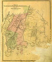 West Farms was separated from the town of Westchester, New York, by an act of the legislature in 1846, formed from the settlements of West Farms, Morrisania
, and Fordham
, which survive as recognizable neighborhoods of The Bronx to this day. The patent of the "West Farms", which were the farthest western section of Westchester, were granted by letters patent in 1666 to Edward Jessup and John Richardson, both of Westchester, who had jointly purchased it "of the Indyan proprietors". It was bounded on the east by the "river commonly called by the Indians Aquehung, otherwise Broncke river
" Jessup was dead within a year, and his widow conveyed his share to Thomas Hunt of Westchester, whose family is commemorated in the name of Hunts Point
. In 1711, the heirs of the patentees joined in a second division of the lands in twelve lots with immutable boundaries, which were subsequently divided up. During the American Revolution
numerous engagements occurred here; there were too few able-bodied men to form a company of continental militia, so West Farms formed a joint company with Fordham.
In 1848 the village of West Farms was described as "pleasantly situated at the head of the navigable waters of the Bronx, three miles from the East river
, and twelve from New York
". Though it was rapidly increasing in size, it already had about 1000 inhabitants, in about 200 houses.There were three district schools, for boys and girls, and a ladies' seminary and a boys' private school. The railroad depot of the Harlem & Westchester Rail Road stood a mile north of the village, where there were four churches, "4 taverns, a temperance house
, 12 stores of different kinds, and a post office." In addition to seven sloop
s moored on the Bronx River, there were manufactories: a Brussels carpet and spinning factory, another carpet manufactory, and a grist mill and a lumber mill, formerly de Lancey's Mills, converting the last stands of timber accessible to the Bronx River upstream. Rail service to the city was on an almost hourly schedule, and West Farms was developing into a railroad suburb like Yonkers
, which bounded it on the north. In 1848 the Hunt house (built in 1688) still stood on Hunts Point at the end of "Planting Neck", and the high ground along the neck was dotted with villas. Poet Joseph Rodman Drake
found inspiration in the views of Long Island Sound
and is buried nearby.
. The vast majority of households are renter occupied.
buildings, older multi-unit homes, vacant lots, and newly constructed subsidized attached multi-unit townhouses and apartment buildings. Most of the original housing stock was structurally damaged by arson and eventually razed by the city. The total land area is less than one square mile. The terrain is somewhat hilly.
West Farms Bus Depot
The West Farms Bus Depot is located along East 177th Street next to a terminated Sheridan Expressway
. Opened on September 7, 2003 on the site of the former Coliseum Depot .
 Many social problems associated with poverty from crime to drug addiction have plagued the area for some time. Despite declines in crime from its peak during the crack and heroin epidemics, violent crime continues to be a serious problem in the community. West Farms has significantly higher drop out rates and incidents of violence in its schools than in other parts of the city.NYC Dropout Rates Students must pass through metal detectors and swipe ID cards to enter the buildings, making them reminiscent of a prison environment, which many feel encourages bad behavior. Other problems in local schools include low test scores and high truancy rates. Drug addiction is also a serious problem in the community. Due to the lucrative drug trade in the area many addicts reside in the community. Peer pressure among children who come from broken homes contributes to the high rate of usage. Many households in the area are headed by a single mother which contributes to the high poverty rate. Many of them had their children at a very young age and could not provide for their children. Many of the families living in West Farms have been in poverty for generations. The incarceration rate in the area is also very high. Many if not most males in the community have been arrested at some point in their lives. This is related to the aggressive policing tactics, including "sweeps", that are used because of the area's high crime rate. West Farms is home to a significant number of inmates currently held in New York state prison and jail facilities.
The Bronx
The Bronx is the northernmost of the five boroughs of New York City. It is also known as Bronx County, the last of the 62 counties of New York State to be incorporated...
, New York City
New York City
New York is the most populous city in the United States and the center of the New York Metropolitan Area, one of the most populous metropolitan areas in the world. New York exerts a significant impact upon global commerce, finance, media, art, fashion, research, technology, education, and...
, also known as the northeast corner of the South Bronx
South Bronx
The South Bronx is an area of the New York City borough of The Bronx. The neighborhoods of Tremont, University Heights, Highbridge, Morrisania, Soundview, Hunts Point, and Castle Hill are sometimes considered part of the South Bronx....
. The neighborhood is part of Bronx Community Board 6
Bronx Community Board 6
Bronx Community Board 6 is a local government unit of the city of New York, encompassing the neighborhoods of Bathgate, Belmont, East Tremont, and West Farms...
. Its boundaries, starting from the north and moving clockwise are: Bronx Park
Bronx Park
Bronx Park, laid out along the Bronx River in the Bronx, New York, is the home of the New York Botanical Garden and the Bronx Zoo. Bicycle paths go northwest, north and east, along Mosholu Parkway, Bronx River Parkway and Pelham Parkway respectively...
to the north, the Bronx River Parkway
Bronx River Parkway
The Bronx River Parkway is a long parkway in downstate New York. It is named for the nearby Bronx River, which it parallels. The southern terminus of the parkway is at Story Avenue near Bruckner Expressway in the Bronx neighborhood of Soundview...
to the east, the Cross-Bronx Expressway
Cross-Bronx Expressway
The Cross Bronx Expressway is a major expressway in the New York City borough of the Bronx, conceived by Robert Moses and built between 1948 and 1972. It carries traffic on Interstate 95 through the city, and serves as a portion of Interstate 295 toward Long Island; a portion is also designated U.S...
to the south, and Crotona Avenue to the west. East Tremont Avenue is the primary thoroughfare through West Farms. The local subway is the IRT White Plains Road Line
IRT White Plains Road Line
The White Plains Road Line is a rapid transit line of the IRT division of the New York City Subway, serving the central Bronx. It is mostly elevated, and served both subway and elevated trains until 1952...
at West Farms Square–East Tremont Avenue (IRT White Plains Road Line), operating along Boston Road and E 180 St (IRT White Plains Road Line) on Morris Park Avenue. Zip codes include 10460. The area is patrolled by the 48th Precinct located at 450 Cross Bronx Expressway in East Tremont
East Tremont, Bronx
East Tremont is a low income residential neighborhood geographically located in the west Bronx, New York City. The neighborhood is part of Bronx Community Board 6. Its boundaries, starting from the north and moving clockwise are: East 183rd Street to the north, Crotona Avenue to the east, the...
. NYCHA property in the area is patrolled by P.S.A. 8 at 2794 Randall Avenue in the Throggs Neck section of the Bronx.
History
Morrisania, Bronx
Morrisania is the historical name for the South Bronx and derives from the powerful and aristocratic Morris family, who at one time owned all of the Manor of Morrisania. Today the name is most commonly associated with the village of Morrisania, which is only a small corner of the original...
, and Fordham
Fordham, Bronx
Fordham is a neighborhood of New York City, United States, located in the West Bronx. The neighborhood is part of Bronx Community Board 5. It is bordered by Fordham Road to the north, Webster Avenue to the east, East 183rd Street to the south, and Jerome Avenue to the west...
, which survive as recognizable neighborhoods of The Bronx to this day. The patent of the "West Farms", which were the farthest western section of Westchester, were granted by letters patent in 1666 to Edward Jessup and John Richardson, both of Westchester, who had jointly purchased it "of the Indyan proprietors". It was bounded on the east by the "river commonly called by the Indians Aquehung, otherwise Broncke river
Bronx River
The Bronx River, approximately long, flows through southeast New York in the United States. It is named after colonial settler Jonas Bronck. The Bronx River is the only fresh water river in New York City....
" Jessup was dead within a year, and his widow conveyed his share to Thomas Hunt of Westchester, whose family is commemorated in the name of Hunts Point
Hunts Point, Bronx
Hunts Point is a low-income neighborhood located on a peninsula in the South Bronx in New York City. It is the location of one of the largest food distribution facilities in the world. The neighborhood is part of Bronx Community Board 2. Its boundaries are the Bruckner Expressway to the west and...
. In 1711, the heirs of the patentees joined in a second division of the lands in twelve lots with immutable boundaries, which were subsequently divided up. During the American Revolution
American Revolution
The American Revolution was the political upheaval during the last half of the 18th century in which thirteen colonies in North America joined together to break free from the British Empire, combining to become the United States of America...
numerous engagements occurred here; there were too few able-bodied men to form a company of continental militia, so West Farms formed a joint company with Fordham.
In 1848 the village of West Farms was described as "pleasantly situated at the head of the navigable waters of the Bronx, three miles from the East river
East River
The East River is a tidal strait in New York City. It connects Upper New York Bay on its south end to Long Island Sound on its north end. It separates Long Island from the island of Manhattan and the Bronx on the North American mainland...
, and twelve from New York
New York City
New York is the most populous city in the United States and the center of the New York Metropolitan Area, one of the most populous metropolitan areas in the world. New York exerts a significant impact upon global commerce, finance, media, art, fashion, research, technology, education, and...
". Though it was rapidly increasing in size, it already had about 1000 inhabitants, in about 200 houses.There were three district schools, for boys and girls, and a ladies' seminary and a boys' private school. The railroad depot of the Harlem & Westchester Rail Road stood a mile north of the village, where there were four churches, "4 taverns, a temperance house
Temperance movement
A temperance movement is a social movement urging reduced use of alcoholic beverages. Temperance movements may criticize excessive alcohol use, promote complete abstinence , or pressure the government to enact anti-alcohol legislation or complete prohibition of alcohol.-Temperance movement by...
, 12 stores of different kinds, and a post office." In addition to seven sloop
Sloop
A sloop is a sail boat with a fore-and-aft rig and a single mast farther forward than the mast of a cutter....
s moored on the Bronx River, there were manufactories: a Brussels carpet and spinning factory, another carpet manufactory, and a grist mill and a lumber mill, formerly de Lancey's Mills, converting the last stands of timber accessible to the Bronx River upstream. Rail service to the city was on an almost hourly schedule, and West Farms was developing into a railroad suburb like Yonkers
Yonkers, New York
Yonkers is the fourth most populous city in the state of New York , and the most populous city in Westchester County, with a population of 195,976...
, which bounded it on the north. In 1848 the Hunt house (built in 1688) still stood on Hunts Point at the end of "Planting Neck", and the high ground along the neck was dotted with villas. Poet Joseph Rodman Drake
Joseph Rodman Drake
Joseph Rodman Drake was an early American poet.- Biography :Born in New York City, he was orphaned when young and entered a mercantile house. While still a child, he showed a talent for writing poems. He was educated at Columbia. In 1813 he began studying in a physician's office...
found inspiration in the views of Long Island Sound
Long Island Sound
Long Island Sound is an estuary of the Atlantic Ocean, located in the United States between Connecticut to the north and Long Island, New York to the south. The mouth of the Connecticut River at Old Saybrook, Connecticut, empties into the sound. On its western end the sound is bounded by the Bronx...
and is buried nearby.
Demographics
West Farms has a population over 20,000. For decades West Farms has been one of the poorest communities in America. Over half the population lives below the poverty line and receives public assistance (AFDC, Home Relief, Supplemental Security Income, and Medicaid). West Farms has one of the highest concentrations of Puerto Ricans in New York CityPuerto Rican migration to New York
Puerto Ricans have both immigrated and migrated to New York. The first group of Puerto Ricans moved to New York in the mid-19th century when Puerto Rico was a Spanish Colony and its people Spanish subjects and therefore they were immigrants. The following wave of Puerto Ricans to move to New York...
. The vast majority of households are renter occupied.
Land use and terrain
West Farms is dominated by 5 and 6-story tenementTenement
A tenement is, in most English-speaking areas, a substandard multi-family dwelling, usually old, occupied by the poor.-History:Originally the term tenement referred to tenancy and therefore to any rented accommodation...
buildings, older multi-unit homes, vacant lots, and newly constructed subsidized attached multi-unit townhouses and apartment buildings. Most of the original housing stock was structurally damaged by arson and eventually razed by the city. The total land area is less than one square mile. The terrain is somewhat hilly.
West Farms Bus Depot
The West Farms Bus Depot is located along East 177th Street next to a terminated Sheridan Expressway
Interstate 895 (New York)
Interstate 895 , named the Arthur V. Sheridan Expressway, is a short freeway in the New York City borough of the Bronx, forming a short connecting link in the Interstate Highway System...
. Opened on September 7, 2003 on the site of the former Coliseum Depot .
Low-income public housing projects
- There are two NYCHA developments located in West Farms.
- 1010 East 178th Street; a 21-story building.
- Twin Parks East (Site 9); a 14-story building.
Social problems
Urban renewal
After a wave of arson ravaged the low-income communities of New York City, especially the Bronx, throughout the 1970s, most residential structures in West Farms were left seriously damaged or destroyed. The city began to rehabilitate many abandoned tenement-style apartment buildings and designate them low-income housing beginning in the late 1970s. Also many subsidized attached multi-unit townhouses and newly constructed apartment buildings have been or are being built on vacant lots across the neighborhood.Schools
- PS 6: West Farms (East Tremont and Bryant Avenues)
- PS 67: Mohegan (East 178th Street and Mohegan Avenue)
- CS 214: Lorraine Hansberry Academy(West Farms Road and East Tremont Avenue)
- Wings Academy (East 180th Street and Bronx Park Avenue)
Transportation
- Bx9: to RiverdaleRiverdale, BronxRiverdale is an affluent residential neighborhood in the northwest portion of the Bronx in New York City. Riverdale contains the northernmost point in New York City.-History:...
(via Kingsbridge Road) - Bx19 to Riverbank State ParkRiverbank State ParkRiverbank State Park is a park built on the top of a sewage treatment facility on the Hudson River, in the New York City borough of Manhattan....
, Manhattan or Bronx ParkBronx ParkBronx Park, laid out along the Bronx River in the Bronx, New York, is the home of the New York Botanical Garden and the Bronx Zoo. Bicycle paths go northwest, north and east, along Mosholu Parkway, Bronx River Parkway and Pelham Parkway respectively...
, The Bronx (via Southern Blvd) (Border of West Farms and East Tremont) - Bx21: to Westchester Square station or Third Avenue–138th Street station (via Boston Road and Morris Park Avenue)
- Bx36 to Castle HillCastle Hill, BronxCastle Hill is primarily a residential neighborhood geographically located in the South Central section of the borough of The Bronx in New York City. The neighborhood is part of Bronx Community Board 9...
or George Washington Bridge Bus TerminalGeorge Washington Bridge Bus TerminalThe George Washington Bridge Bus Station is a commuter bus terminal located at the east end of the George Washington Bridge in the Washington Heights area of Manhattan in New York City, New York....
(via 180th Street) - Bx40/42: to Throgs Neck or Morris HeightsMorris Heights, BronxMorris Heights is a low income residential neighborhood located in the west Bronx. The neighborhood is part of Bronx Community Board 5. Its boundaries, starting from the north and moving clockwise are: West Burnside Avenue to the north, Jerome Avenue to the east, the Cross-Bronx Expressway to the...
(via Tremont–Burnside Avs) - Q44: to JamaicaJamaica, QueensJamaica is a neighborhood in the borough of Queens in New York City, New York, United States. It was settled under Dutch rule in 1656 in New Netherland as Rustdorp. Under British rule, the Village of Jamaica became the center of the "Town of Jamaica"...
, WhitestoneWhitestone, QueensWhitestone is a residential neighborhood in the northernmost part of the City of New York borough of Queens. Located between the East River to the north and 25th Avenue to the south. Whitestone is surrounded by College Point, Flushing, Bayside, Auburndale, Linden Hill, and Murray Hill...
, FlushingFlushing, QueensFlushing, founded in 1645, is a neighborhood in the north central part of the City of New York borough of Queens, east of Manhattan.Flushing was one of the first Dutch settlements on Long Island. Today, it is one of the largest and most diverse neighborhoods in New York City...
(via Cross Bronx Expressway Service Road and Main Street in Queens) - East 180th Street (IRT White Plains Road Line)East 180th Street (IRT White Plains Road Line)For the previous 180th Street station on the IRT White Plains Road Line, see 180th Street – Bronx Park .East 180th Street is an express station on the IRT White Plains Road Line of the New York City Subway...
- West Farms Square–East Tremont Avenue (IRT White Plains Road Line)
Facts
- This particular neighborhood is known for its illegal sex trade, primarily street level prostitution.
- West Farms is often considered part of the socioeconomic South BronxSouth BronxThe South Bronx is an area of the New York City borough of The Bronx. The neighborhoods of Tremont, University Heights, Highbridge, Morrisania, Soundview, Hunts Point, and Castle Hill are sometimes considered part of the South Bronx....
.