
National Register of Historic Places listings in Inyo County, California
Encyclopedia
This list includes properties and districts listed on the National Register of Historic Places
in Inyo County, California
. Click the "Map of all coordinates" link to the right to view a Google map of all properties and districts with latitude and longitude coordinates in the table below.
National Register of Historic Places
The National Register of Historic Places is the United States government's official list of districts, sites, buildings, structures, and objects deemed worthy of preservation...
in Inyo County, California
Inyo County, California
-National protected areas:* Death Valley National Park * Inyo National Forest * Manzanar National Historic Site-Major highways:* U.S. Route 6* U.S. Route 395* State Route 127* State Route 136* State Route 168* State Route 178...
. Click the "Map of all coordinates" link to the right to view a Google map of all properties and districts with latitude and longitude coordinates in the table below.
| Landmark name | Image | Date listed | Location | City or Town | Summary | |
|---|---|---|---|---|---|---|
| 1 | Archeological Site CA-INY-134 | Address Restricted | Olancha Olancha, California Olancha is a census-designated place in Inyo County of the U.S. state of California. Olancha is located on U.S. Route 395 in California, south-southeast of Independence, at an elevation of 3658 feet... |
|||
| 2 | Big and Little Petroglyph Canyons Big and Little Petroglyph Canyons Big and Little Petroglyph Canyons are two principal landforms within which are found major accumulations of Paleo-Indian and/or Native American Petroglyphs, or rock art, by the Coso People located in the Coso Range Mountains of the northern Mojave Desert, and now within the Naval Air Weapons... |
Address Restricted | Coso Range Coso Range The Coso Range of eastern California is located immediately south of Owens Lake , east of the Sierra Nevada Mountains, and west of the Argus Range. The southern part of the range lies in the restricted Naval Air Weapons Station China Lake... , China Lake |
|||
| 3 | Coso Hot Springs Coso Hot Springs Coso Hot Springs is a hot spring complex in the Coso Volcanic Field in the Mojave Desert of Inyo County, California. The Springs are on the National Register of Historic Places.-Geography:... |
 |
Address Restricted | Coso Volcanic Field Coso Volcanic Field The Coso Volcanic Field is located in Inyo County, California, at the western edge of the Basin and Range geologic province and northern region of the Mojave Desert. The Fossil Falls are part of the Coso Field, created by the prehistoric Owens River. They are currently within the Naval Air Weapons... , Little Lake |
||
| 4 | Coso Rock Art District Coso Rock Art District Coso Rock Art District, containing the Big and Little Petroglyph Canyons, is a rock art site containing over 20,000 of Paleo-Indian and/or Native American Petroglyphs The Coso Range is between the Sierra Nevada and the Argus Range. Indian Wells Valley lies to the south of this location... |
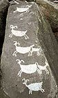 |
Address Restricted | Coso Range Coso Range The Coso Range of eastern California is located immediately south of Owens Lake , east of the Sierra Nevada Mountains, and west of the Argus Range. The southern part of the range lies in the restricted Naval Air Weapons Station China Lake... China Lake |
||
| 5 | Amargosa Opera House and Hotel Amargosa Opera House and Hotel Amargosa Opera House and Hotel is a historic building and cultural center located in Death Valley Junction, in eastern Inyo County, California near Death Valley National Park. Resident artist Marta Becket has staged dance and mime shows there since the late 1960s... , Death Valley Junction Historic District |
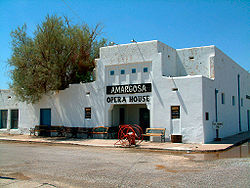 |
State Route 127 California State Route 127 State Route 127 is a California state highway that connects Interstate 15 to Nevada State Route 373, passing through Death Valley National Park.... and State Route 190 California State Route 190 State Route 190 is a state highway in the U.S. state of California that is split into two parts by the Sierra Nevada. The western portion of begins at Tipton at a junction with State Route 99 and heads east towards Porterville before ending at Quaking Aspen in the Sequoia National Forest... 36°18′8"N 116°24′54"W |
Death Valley Junction Death Valley Junction, California Death Valley Junction is a tiny Mojave Desert community in unincorporated Inyo County, California, at the intersection of SR 190 and SR 127, just east of Death Valley National Park. The zip code is 92328, the elevation is , and the population fewer than 20. The city limits sign reports a... |
||
| 6 | Death Valley Scotty Historic District Scotty's Castle Scotty's Castle is a two-story Mission Revival and Spanish Colonial Revival style villa located in the Grapevine Mountains of northern Death Valley in Death Valley National Park, California, U.S.. It is also known as Death Valley Ranch... |
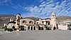 |
On State Route 72 California State Route 72 State Route 72 is a state highway in the U.S. state of California. The route runs from Puente Street in Brea to Atlantic Boulevard in East Los Angeles. It forms part of El Camino Real.-Route description:... , Death Valley National Park Death Valley National Park Death Valley National Park is a national park in the U.S. states of California and Nevada located east of the Sierra Nevada in the arid Great Basin of the United States. The park protects the northwest corner of the Mojave Desert and contains a diverse desert environment of salt-flats, sand dunes,... 37°1′33"N 117°22′2"W |
Grapevine Canyon Grapevine Mountains The Grapevine Mountains are located along the eastern border of California in the United States. The mountain range is about long and lies in a northwest-southeasterly direction along the Nevada-California state line. The range reaches an elevation of at Grapevine Peak, near Phinney Canyon on the... Death Valley National Park Death Valley National Park Death Valley National Park is a national park in the U.S. states of California and Nevada located east of the Sierra Nevada in the arid Great Basin of the United States. The park protects the northwest corner of the Mojave Desert and contains a diverse desert environment of salt-flats, sand dunes,... |
||
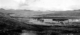
| 7 | Eagle Borax Works Eagle Borax Works The Eagle Borax Works in Death Valley, California was established near Bennetts Well in 1882 by Isidore Daunet, J.M. McDonald, M. Harmon and C.C. Blanch to mine the borate deposits that Daunet discovered there in 1880. The partnership established the first borax works in the valley... |
Death Valley National Park 36°12′4"N 116°51′54"W |
Furnace Creek Furnace Creek, California Furnace Creek is a census-designated place in Inyo County, California, United States. The population was 24 at the 2010 census, down from 31 at the 2000 census. The elevation of the village is below sea level.... Death Valley National Park Death Valley National Park Death Valley National Park is a national park in the U.S. states of California and Nevada located east of the Sierra Nevada in the arid Great Basin of the United States. The park protects the northwest corner of the Mojave Desert and contains a diverse desert environment of salt-flats, sand dunes,... |
|||
| 8 | Fossil Falls Archeological District Fossil Falls The Fossil Falls is a unique geological feature, located in the Coso Range of California in the United States. Volcanic activity in the mountain range, along with meltwater from glaciers in the nearby Sierra Nevada, played a role in the creation of the falls... |
Restricted | Little Lake | |||
| 9 | Harmony Borax Works Harmony Borax Works The Harmony Borax Works are located in Death Valley at Furnace Creek Springs, then called Greenland. They are now within Death Valley National Park in Inyo County, California... |
 |
Death Valley National Park Death Valley National Park Death Valley National Park is a national park in the U.S. states of California and Nevada located east of the Sierra Nevada in the arid Great Basin of the United States. The park protects the northwest corner of the Mojave Desert and contains a diverse desert environment of salt-flats, sand dunes,... 35°29′16"N 116°52′26"W |
Stovepipe Wells Stovepipe Wells, California Stovepipe Wells is a small way-station in the northern part of Death Valley, in unincorporated Inyo County, California.-Geography and names:Stovepipe Wells is located at and is US Geological Survey feature ID 235564. It is entirely inside Death Valley National Park and along State Route 190 at... Death Valley National Park Death Valley National Park Death Valley National Park is a national park in the U.S. states of California and Nevada located east of the Sierra Nevada in the arid Great Basin of the United States. The park protects the northwest corner of the Mojave Desert and contains a diverse desert environment of salt-flats, sand dunes,... |
||
| 10 | Inyo County Courthouse | 168 N. Edwards Street, Independence Independence, California Independence is the county seat of Inyo County, California. Independence is located south-southeast of Bishop, at an elevation of 3930 feet . The population of this census-designated place was 669 at the 2010 census, up from 574 at the 2000 census.... 36°48′13"N 118°11′56"W |
Independence Independence, California Independence is the county seat of Inyo County, California. Independence is located south-southeast of Bishop, at an elevation of 3930 feet . The population of this census-designated place was 669 at the 2010 census, up from 574 at the 2000 census.... |
|||
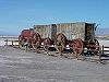
| 11 | Laws Narrow Gauge Railroad Historic District | U.S. Route 6 U.S. Route 6 U.S. Route 6 , also called the Grand Army of the Republic Highway, a name that honors an American Civil War veterans association, is a main route of the U.S. Highway system, running east-northeast from Bishop, California to Provincetown, Massachusetts. Until 1964, it continued south from Bishop to... , northeast of Bishop Bishop, California Bishop is a city in Inyo County, California, United States. Though Bishop is the only city and the largest populated place in Inyo County, the county seat is Independence. Bishop is located near the northern end of the Owens Valley, at an elevation of 4147 feet . The population was 3,879 at the... 37°24′6"N 118°20′50"W |
Laws Laws, California Laws is an unincorporated community in Inyo County, California.Laws is located northeast of Bishop on U.S. Route 6, towards the Nevada state line.-Geography:... |
|||
| 12 | Leadfield Leadfield, California Leadfield was an unincorporated community, and historic mining town in Inyo County, California. It is now a ghost town. It is located in Titus Canyon in the Grapevine Mountains, east of Death Valley in Death Valley National Park. Leadfield lies at an elevation of 4058 feet... |
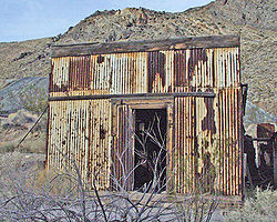 |
Death Valley National Park Death Valley National Park Death Valley National Park is a national park in the U.S. states of California and Nevada located east of the Sierra Nevada in the arid Great Basin of the United States. The park protects the northwest corner of the Mojave Desert and contains a diverse desert environment of salt-flats, sand dunes,... , on Titus Canyon Trail Titus Canyon Titus Canyon is a deep, narrow gorge cut into the steep face of the Grapevine Mountains to the east of Death Valley in the Mojave Desert of southeastern California... 36°50′50"N 117°3′27"W |
Titus Canyon Titus Canyon Titus Canyon is a deep, narrow gorge cut into the steep face of the Grapevine Mountains to the east of Death Valley in the Mojave Desert of southeastern California... , Grapevine Mountains Grapevine Mountains The Grapevine Mountains are located along the eastern border of California in the United States. The mountain range is about long and lies in a northwest-southeasterly direction along the Nevada-California state line. The range reaches an elevation of at Grapevine Peak, near Phinney Canyon on the... Death Valley National Park Death Valley National Park Death Valley National Park is a national park in the U.S. states of California and Nevada located east of the Sierra Nevada in the arid Great Basin of the United States. The park protects the northwest corner of the Mojave Desert and contains a diverse desert environment of salt-flats, sand dunes,... |
||
| 13 | Manzanar War Relocation Center, National Historic Site Manzanar Manzanar is most widely known as the site of one of ten camps where over 110,000 Japanese Americans were imprisoned during World War II. Located at the foot of the Sierra Nevada in California's Owens Valley between the towns of Lone Pine to the south and Independence to the north, it is... |
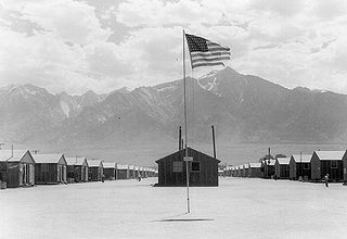 |
U.S. Route 395 U.S. Route 395 in California In the U.S. state of California, U.S. Route 395 is a route which traverses from Interstate 15 near the southern city limits of Hesperia, north to the Oregon state line in Modoc County near Goose Lake... ; 6 miles south of Independence Independence, California Independence is the county seat of Inyo County, California. Independence is located south-southeast of Bishop, at an elevation of 3930 feet . The population of this census-designated place was 669 at the 2010 census, up from 574 at the 2000 census.... 36°43′42"N 118°9′16"W |
Independence Independence, California Independence is the county seat of Inyo County, California. Independence is located south-southeast of Bishop, at an elevation of 3930 feet . The population of this census-designated place was 669 at the 2010 census, up from 574 at the 2000 census.... |
||
| 14 | Pawona Witu | Address Restricted | Bishop Bishop, California Bishop is a city in Inyo County, California, United States. Though Bishop is the only city and the largest populated place in Inyo County, the county seat is Independence. Bishop is located near the northern end of the Owens Valley, at an elevation of 4147 feet . The population was 3,879 at the... |
|||
| 15 | Reilly Reilly, California Reilly is a former settlement in Inyo County, California. It was located on the west side of the Panamint Valley, at an elevation of 2582 feet . Reilly was a silver mining community in the late 19th century.A post office operated at Reilly in 1883.... |
Address Restricted | Searles Lake Searles Lake Searles Lake is an endorheic dry lake in the Mojave Desert of San Bernardino County, California, with the mining community, Trona on its western shore. The evaporite basin is approximately long and at its widest point, yielding 1.7 million tons annually of industrial minerals within the basin to... Trona Trona, California Trona is an unincorporated community in San Bernardino County, California. In 2000 it had a population of 2,742. Trona is at the western edge of Searles Lake, a dry lake bed in Searles Valley, southwest of Death Valley. The town takes its name from the mineral trona, abundant in the lakebed.It is... |
|||
| 16 | Saline Valley Salt Tram Historic Structure Saline Valley, California Saline Valley is a large, deep, and arid valley in the northern Mojave Desert of California. Most of it became a part of Death Valley National Park when the park expanded in 1994. This area had previously been administered by the BLM. It is located northwest of Death Valley proper, south of... |
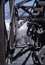 |
Inyo Mountains Inyo Mountains The Inyo Mountains are a short mountain range east of the Sierra Nevada mountains in eastern California in the United States. The range separates the Owens Valley to the west with Saline Valley to the east, extending for approximately 70 mi SSE from the southern end of the White Mountains,... , north of Keeler Keeler, California Keeler is a census-designated place in Inyo County, California, United States. Keeler is located on the east shore of Owens Lake south-southeast of New York Butte, at an elevation of 3602 feet... between Gordo Peak and New York Butte 36°36′39"N 117°51′19"W |
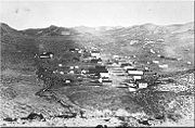
Cerro Gordo District Cerro Gordo Mines The Cerro Gordo Mines were a collection of mines located in the Inyo Mountains, in Inyo County, California. Mining operations were undertaken from 1866 until 1957, producing high grade silver, lead, and zinc ore. Some ore was smelted on site, however the remote location led to larger scale... Inyo Mountains Inyo Mountains The Inyo Mountains are a short mountain range east of the Sierra Nevada mountains in eastern California in the United States. The range separates the Owens Valley to the west with Saline Valley to the east, extending for approximately 70 mi SSE from the southern end of the White Mountains,... |
||
| 17 | Skidoo Skidoo, California Skidoo is an unincorporated community in Inyo County, California. It lies at an elevation of 5689 feet . Skidoo is a virtual ghost town located in Death Valley National Park. It is on the National Register of Historic Places... |
 |
Death Valley National Park Death Valley National Park Death Valley National Park is a national park in the U.S. states of California and Nevada located east of the Sierra Nevada in the arid Great Basin of the United States. The park protects the northwest corner of the Mojave Desert and contains a diverse desert environment of salt-flats, sand dunes,... , Wildrose District 36°25′59"N 117°7′46"W |
Panamint Range Panamint Range The Panamint Range is a short rugged fault-block mountain range on the northern edge of the Mojave Desert, in Death Valley National Park, Inyo County, California, United States.-Geography:... Death Valley National Park Death Valley National Park Death Valley National Park is a national park in the U.S. states of California and Nevada located east of the Sierra Nevada in the arid Great Basin of the United States. The park protects the northwest corner of the Mojave Desert and contains a diverse desert environment of salt-flats, sand dunes,... |
See also
- National Register of Historic Places listings in California
- List of National Historic Landmarks in California