

Laws, California
Encyclopedia
Unincorporated area
In law, an unincorporated area is a region of land that is not a part of any municipality.To "incorporate" in this context means to form a municipal corporation, a city, town, or village with its own government. An unincorporated community is usually not subject to or taxed by a municipal government...
in Inyo County
Inyo County, California
-National protected areas:* Death Valley National Park * Inyo National Forest * Manzanar National Historic Site-Major highways:* U.S. Route 6* U.S. Route 395* State Route 127* State Route 136* State Route 168* State Route 178...
, California
California
California is a state located on the West Coast of the United States. It is by far the most populous U.S. state, and the third-largest by land area...
.
Laws is located 4 miles (6.4 km) northeast of Bishop
Bishop, California
Bishop is a city in Inyo County, California, United States. Though Bishop is the only city and the largest populated place in Inyo County, the county seat is Independence. Bishop is located near the northern end of the Owens Valley, at an elevation of 4147 feet . The population was 3,879 at the...
on U.S. Route 6
U.S. Route 6
U.S. Route 6 , also called the Grand Army of the Republic Highway, a name that honors an American Civil War veterans association, is a main route of the U.S. Highway system, running east-northeast from Bishop, California to Provincetown, Massachusetts. Until 1964, it continued south from Bishop to...
, towards the Nevada
Nevada
Nevada is a state in the western, mountain west, and southwestern regions of the United States. With an area of and a population of about 2.7 million, it is the 7th-largest and 35th-most populous state. Over two-thirds of Nevada's people live in the Las Vegas metropolitan area, which contains its...
state line.
Geography
The U.S. Geological Survey shows official coordinates for the town as 37°24′03"N 118°20′44"W. The town is in ZIP codeZIP Code
ZIP codes are a system of postal codes used by the United States Postal Service since 1963. The term ZIP, an acronym for Zone Improvement Plan, is properly written in capital letters and was chosen to suggest that the mail travels more efficiently, and therefore more quickly, when senders use the...
93514 and area code 760
Area code 760
Image:Area_code_442.svg|right|Map of California area codes in blue with 442/760 in redrect 65 82 92 100 Area code 916rect 220 242 245 256 Area code 909rect 243 274 265 287 Area code 951rect 136 323 160 338 Area code 858...
. . The official elevation is 4117 feet (1,254.9 m) AMSL. The town is bordered by the White Mountains
White Mountains (California)
The White Mountains of California are a triangular fault block mountain range facing the Sierra Nevada across the upper Owens Valley. They extend for approximately as a greatly elevated plateau about wide on the south, narrowing to a point at the north, with elevations generally increasing...
to the east and the Sierra Nevada Mountains, the "Eastern Sierras," to the west. It is located near the Owens River
Owens River
The Owens River is a river in southeastern California in the United States, approximately long. It drains into and through the Owens Valley, an arid basin between the eastern slope of the Sierra Nevada and the western faces of the Inyo and White Mountains. The river terminates at Owens Lake, but...
in upper Owens Valley
Owens Valley
Owens Valley is the arid valley of the Owens River in eastern California in the United States, to the east of the Sierra Nevada and west of the White Mountains and Inyo Mountains on the west edge of the Great Basin section...
.
History
The settlement of Station was formed in 1883 as a depot on the Carson and Colorado RailroadCarson and Colorado Railroad
The Carson and Colorado Railway was a U.S. narrow gauge railroad that ran from Mound House, Nevada, to Keeler, California below the Cerro Gordo Mines. It was incorporated on May 10, 1880 as the Carson and Colorado Railroad, and construction on the railroad began on May 31, 1880. A track gauge of ...
. The name was changed to Laws in honor of R.J. Laws, a railroad official. A post office operated at Laws from 1887 to 1963. The town of Laws was a railroad station along a Narrow gauge railway portion of the Southern Pacific Railroad
Southern Pacific Railroad
The Southern Pacific Transportation Company , earlier Southern Pacific Railroad and Southern Pacific Company, and usually simply called the Southern Pacific or Espee, was an American railroad....
.
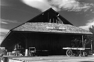
Today the town of Laws exists as a museum of Owens Valley and Eastern Sierra Nevada history. It is on the National Register of Historic Places
National Register of Historic Places
The National Register of Historic Places is the United States government's official list of districts, sites, buildings, structures, and objects deemed worthy of preservation...
.
Railroads displays
The Laws Railroad Museum and Historic Site includes static displays of a train consisting of an oil-fired steam engineSteam generator (railroad)
Steam generator is the term used to describe a type of boiler used to produce steam for climate control and potable water heating in railroad passenger cars...
Steam locomotive
Steam locomotive
A steam locomotive is a railway locomotive that produces its power through a steam engine. These locomotives are fueled by burning some combustible material, usually coal, wood or oil, to produce steam in a boiler, which drives the steam engine...
and several freight cars from the narrow gauge Southern Pacific Railroad
Southern Pacific Railroad
The Southern Pacific Transportation Company , earlier Southern Pacific Railroad and Southern Pacific Company, and usually simply called the Southern Pacific or Espee, was an American railroad....
. The museum's display explains that the railroad was relied on by many Eastern Sierra communities before modern roads were built during the 1950s and 1960s.
A station agent
Station agent
In many countries, the station agent is the person in charge of a railway station Variants of station agents can also work at other transit terminals such as airports, ferry terminals, etc....
's home is located south of the railroad station. Docents portray the station agent on most days, helping visitors understand the period culture.
The Museum includes several historic buildings moved to the museum site from downtown Bishop. There is a church and school house. There is a wooden Western Electric
Western Electric
Western Electric Company was an American electrical engineering company, the manufacturing arm of AT&T from 1881 to 1995. It was the scene of a number of technological innovations and also some seminal developments in industrial management...
11-type telephone booth
Telephone booth
A telephone booth, telephone kiosk, telephone call box or telephone box is a small structure furnished with a payphone and designed for a telephone user's convenience. In the USA, Canada and Australia, "telephone booth" is used, while in the UK and the rest of the Commonwealth it is a "telephone...
. A vehicle on display was a 1949 ambulance
Ambulance
An ambulance is a vehicle for transportation of sick or injured people to, from or between places of treatment for an illness or injury, and in some instances will also provide out of hospital medical care to the patient...
, which was later painted black, stripped of emergency lighting, and used as a hearse
Hearse
A hearse is a funerary vehicle used to carry a coffin from a church or funeral home to a cemetery. In the funeral trade, hearses are often called funeral coaches.-History:...
. Medical implements from a historic local doctor's office are on display.
Owens Valley history displays
Owens ValleyOwens Valley
Owens Valley is the arid valley of the Owens River in eastern California in the United States, to the east of the Sierra Nevada and west of the White Mountains and Inyo Mountains on the west edge of the Great Basin section...
history, including construction and impact of the Los Angeles Aqueduct
Los Angeles Aqueduct
The Los Angeles Aqueduct system comprising the Los Angeles Aqueduct and the Second Los Angeles Aqueduct, is a water conveyance system operated by the Los Angeles Department of Water and Power...
project, or "Owens Valley Aqueduct," is described in Museum displays. Today, land on all sides of the museum is property of the Los Angeles Department of Water and Power
Los Angeles Department of Water and Power
The Los Angeles Department of Water and Power is the largest municipal utility in the United States, serving over four million residents. It was founded in 1902 to supply water and electricity to residents and businesses in Los Angeles and surrounding communities...
, of the City of Los Angeles
Los Angeles, California
Los Angeles , with a population at the 2010 United States Census of 3,792,621, is the most populous city in California, USA and the second most populous in the United States, after New York City. It has an area of , and is located in Southern California...
. Photographs and docents show and explain that the Valley included large tracts of agricultural land; from the Paiute
Paiute
Paiute refers to three closely related groups of Native Americans — the Northern Paiute of California, Idaho, Nevada and Oregon; the Owens Valley Paiute of California and Nevada; and the Southern Paiute of Arizona, southeastern California and Nevada, and Utah.-Origin of name:The origin of...
Native American era, through pioneer days, to the Aqueduct 'water wars era
California Water Wars
The California Water Wars were a series of conflicts between the city of Los Angeles, farmers and ranchers in the Owens Valley of Eastern California, and environmentalists. As Los Angeles grew in the late 1800s, it started to outgrow its water supply. Fred Eaton, mayor of Los Angeles, realized that...
' that began diversions of water in the early 20th century to Los Angeles. A tour docent, sharing a vintage black-and-white photograph, explained "This is a picture of my mom's apple orchard
Orchard
An orchard is an intentional planting of trees or shrubs that is maintained for food production. Orchards comprise fruit or nut-producing trees which are grown for commercial production. Orchards are also sometimes a feature of large gardens, where they serve an aesthetic as well as a productive...
."
Government
In the state legislatureCalifornia State Legislature
The California State Legislature is the state legislature of the U.S. state of California. It is a bicameral body consisting of the lower house, the California State Assembly, with 80 members, and the upper house, the California State Senate, with 40 members...
Laws is located in the 18th Senate
California State Senate
The California State Senate is the upper house of the California State Legislature. There are 40 state senators. The state legislature meets in the California State Capitol in Sacramento. The Lieutenant Governor is the ex officio President of the Senate and may break a tied vote...
District, represented by Republican
Republican Party (United States)
The Republican Party is one of the two major contemporary political parties in the United States, along with the Democratic Party. Founded by anti-slavery expansion activists in 1854, it is often called the GOP . The party's platform generally reflects American conservatism in the U.S...
Roy Ashburn
Roy Ashburn
Roy Arthur Ashburn is an American politician from Kern County, California. A Republican, he served as a California State Senator from 2002 to 2010 representing the 18th district. He previously served three terms in the California State Assembly, representing the 32nd district and 12 years on the...
, and in the 18th Assembly
California State Assembly
The California State Assembly is the lower house of the California State Legislature. There are 80 members in the Assembly, representing an approximately equal number of constituents, with each district having a population of at least 420,000...
District, represented by Republican Bill Maze
Bill Maze
Bill Maze is an American politician from California and a member of the Republican Party. Maze is the president of Citizens for Saving California Farming Industries, a non-profit dedicated to dividing California into two states....
. Federally, Laws is located in California's 25th congressional district
California's 25th congressional district
California's 25th congressional district is a congressional district in the U.S. state of California that covers part of Los Angeles County and extends out to broad stretches of interior California along the Nevada border. It includes the cities of Santa Clarita, Palmdale, Lancaster, and the...
, which has a Cook PVI
Cook Partisan Voting Index
The Cook Partisan Voting Index , sometimes referred to as simply the Partisan Voting Index , is a measurement of how strongly an American congressional district or state leans toward one political party compared to the nation as a whole...
of R +7 and is represented by Republican Buck McKeon
Howard McKeon
Howard Philip "Buck" McKeon is the U.S. Representative for , serving since 1993. He is a member of the Republican Party.-Early life, education and career:...
.
Desert railroads
- Tonopah and Tidewater RailroadTonopah and Tidewater RailroadThe Tonopah and Tidewater Railroad, the T&T, was a class II railroad extending through remote reaches of the Mojave Desert from the Santa Fe Railway railhead at Ludlow, California, through Death Valley and Amargosa Valley, terminating at the Mining towns of Tonopah and Goldfield in the Great Basin...
- Las Vegas and Tonopah RailroadLas Vegas and Tonopah RailroadThe Las Vegas and Tonopah Railroad was a 197.9 mile railroad built by William A. Clark that ran northwest from a connection with the mainline of the San Pedro, Los Angeles and Salt Lake Railroad at Las Vegas, Nevada to the gold mines at Goldfield...
- Carson and Colorado Railway
- Death Valley RailroadDeath Valley RailroadThe Death Valley Railroad was a narrow gauge railroad that operated in California's Death Valley.It was built in 1914 by the Pacific Coast Borax Company to carry borax with the route running from Ryan, California, located just east of Death Valley National Park, to Death Valley Junction, a distance...
- Borate and Daggett RailroadBorate and Daggett RailroadThe Borate and Daggett Railroad was a narrow gauge railroad built to carry borax in the Mojave Desert. The railroad ran about 11 miles from Daggett, California, USA to Borate, California, USA.-History:...
- Calico and Odessa RailroadCalico and Odessa RailroadThe Calico & Odessa Railroad is a heritage railroad in the ghost town of Calico, California, headquartered in Yermo, California.Calico itself is an old mining town turned living-history museum. Actual building and railroad equipment were taken from Calico to the Knott's Berry Farm.-External links:**...
- Trona RailwayTrona RailwayThe Trona Railway is a shortline railroad owned by Searles Valley Minerals.The TRC interchanges with the Union Pacific Railroad at Searles, California....
- List of defunct California railroads
- List of defunct Nevada railroads
Locale
- Bishop, CaliforniaBishop, CaliforniaBishop is a city in Inyo County, California, United States. Though Bishop is the only city and the largest populated place in Inyo County, the county seat is Independence. Bishop is located near the northern end of the Owens Valley, at an elevation of 4147 feet . The population was 3,879 at the...
- California Water WarsCalifornia Water WarsThe California Water Wars were a series of conflicts between the city of Los Angeles, farmers and ranchers in the Owens Valley of Eastern California, and environmentalists. As Los Angeles grew in the late 1800s, it started to outgrow its water supply. Fred Eaton, mayor of Los Angeles, realized that...
- Cadillac DesertCadillac DesertCadillac Desert, by Marc Reisner, is a 1986 book published by Viking about land development and water policy in the western United States. Subtitled The American West and its Disappearing Water, it gives the history of the Bureau of Reclamation and U.S. Army Corps of Engineers, and their struggle...
- Fish Slough Area of Critical Environmental ConcernFish Slough Area of Critical Environmental ConcernThe Fish Slough Area of Critical Environmental Concern is a Slough located near Bishop, California on the western side of the Chalfant Valley . Its were designated as an Area of Critical Environmental Concern in 1982...
- Category: Geography of Inyo County, California
- Inyo National ForestInyo National ForestInyo National Forest is a federally administered forest in the United States. The forest covers parts of the eastern Sierra Nevada of California, and the White Mountains of California and Nevada. It contains two wilderness areas: the John Muir Wilderness and the Ansel Adams Wilderness...
- ManzanarManzanarManzanar is most widely known as the site of one of ten camps where over 110,000 Japanese Americans were imprisoned during World War II. Located at the foot of the Sierra Nevada in California's Owens Valley between the towns of Lone Pine to the south and Independence to the north, it is...
- Owens RiverOwens RiverThe Owens River is a river in southeastern California in the United States, approximately long. It drains into and through the Owens Valley, an arid basin between the eastern slope of the Sierra Nevada and the western faces of the Inyo and White Mountains. The river terminates at Owens Lake, but...
Sources
- Map: "Laws, California 7.5-minute Quadrangle," U.S. Geological Survey, 1994.
- Map: "Guide to Eastern Sierra, #2463" Automobile Club of Southern California, 1996.
- Map: "Inyo National Forest," U.S. Dept. of Agriculture, U.S. Forest Service, Geometronics Service Center, 1989.
- U.S. Geological Survey, National Geographic Names Database.