
California State Route 72
Encyclopedia

U.S. state
A U.S. state is any one of the 50 federated states of the United States of America that share sovereignty with the federal government. Because of this shared sovereignty, an American is a citizen both of the federal entity and of his or her state of domicile. Four states use the official title of...
of California
California
California is a state located on the West Coast of the United States. It is by far the most populous U.S. state, and the third-largest by land area...
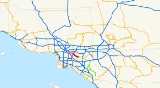
. The route runs from Puente Street in Brea
Brea, California
Brea is a city in Orange County, California. The population, as of the 2010 Census was 39,282.The city began as a center of crude oil production, was later propelled by citrus production, and is now an important retail center because of the large Brea Mall and the recently redeveloped Brea Downtown...
to Atlantic Boulevard in East Los Angeles
East Los Angeles, California
East Los Angeles is an unincorporated area and census-designated place in Los Angeles County, California, United States...
. It forms part of El Camino Real
El Camino Real (California)
El Camino Real and sometimes associated with Calle Real usually refers to the 600-mile California Mission Trail, connecting the former Alta California's 21 missions , 4 presidios, and several pueblos, stretching from Mission San Diego de Alcalá in San Diego...
.
Route description
Route 72 begins at the corner of Whittier Boulevard and Puente Street in Brea. The route follows Whittier Boulevard for its entire length, heading northwest through WhittierWhittier, California
Whittier is a city in Los Angeles County, California about southeast of Los Angeles. The city had a population of 85,331 at the 2010 census, up from 83,680 as of the 2000 census, and encompasses 14.7 square miles . Like nearby Montebello, the city constitutes part of the Gateway Cities...
, as a multi-lane arterial street. Whittier Boulevard is a major commercial corridor in Whittier, though it does not go through the city center. West of the San Gabriel River (605) Freeway
Interstate 605
Interstate 605 is a major north–south Interstate Highway in the Greater Los Angeles Area of Southern California...
, the route goes under a railroad bridge near Pio Pico State Historic Park
Pio Pico State Historic Park
Pío Pico State Historic Park is the site of "El Ranchito," also known as the Pío Pico Adobe or Pío Pico Mansion, the final home of Pío Pico, the last Governor of Alta California under Mexican rule and a pivotal figure in early California history. Located in Whittier, California, at 6003 Pioneer...
and then over the San Gabriel River
San Gabriel River (California)
The San Gabriel River flows through southern Los Angeles County, California in the United States. Its main stem is about long, while its farthest tributaries extend almost altogether...
as it enters Pico Rivera
Pico Rivera, California
Pico Rivera is a city located in southeastern Los Angeles County, California, United States. The city is situated approximately 11 miles southeast of downtown Los Angeles, on the eastern edge of the Los Angeles basin, and on the southern edge of the area known as the San Gabriel Valley...
and meets State Route 19
State Route 19 (California)
State Route 19 , also known as Lakewood Boulevard and Rosemead Boulevard, is a state highway in the Los Angeles area of the U.S. state of California...
at Rosemead Boulevard. After a mile, the route crosses a much more narrow steel bridge over the Rio Hondo into Montebello
Montebello, California
Montebello is a city in Los Angeles County, California, United States, in the southwestern part of the San Gabriel Valley. It is located on of land just east of downtown Los Angeles. It is considered part of the Gateway Cities, and the city is a member of the Gateway Cities Council of...
. There, it continues towards Atlantic Boulevard.
The route formerly continued further down to an unusual end at Downey Road. West of the Long Beach (710) Freeway, the watchful driver can spot a blue
Blue
Blue is a colour, the perception of which is evoked by light having a spectrum dominated by energy with a wavelength of roughly 440–490 nm. It is considered one of the additive primary colours. On the HSV Colour Wheel, the complement of blue is yellow; that is, a colour corresponding to an equal...
sign
Traffic sign
Traffic signs or road signs are signs erected at the side of roads to provide information to road users. With traffic volumes increasing over the last eight decades, many countries have adopted pictorial signs or otherwise simplified and standardized their signs to facilitate international travel...
assembly, informing truckers of the end of Terminal Access, just before approaching the Downey Road signal. This assembly announces the route's abortive end. (Whittier Boulevard itself continues past Downey Road towards downtown Los Angeles. See below.)
Despite the fact that routes in California
California
California is a state located on the West Coast of the United States. It is by far the most populous U.S. state, and the third-largest by land area...
are defined from west to east and from south to north, Route 72 is actually defined in the opposite direction, from east to west. This reflects the fact that Route 72, having been derived from the longitudinal
Longitude
Longitude is a geographic coordinate that specifies the east-west position of a point on the Earth's surface. It is an angular measurement, usually expressed in degrees, minutes and seconds, and denoted by the Greek letter lambda ....
U.S. Route 101, was actually a south–north highway, pivoting at Whittier and Harbor Boulevard
Boulevard
A Boulevard is type of road, usually a wide, multi-lane arterial thoroughfare, divided with a median down the centre, and roadways along each side designed as slow travel and parking lanes and for bicycle and pedestrian usage, often with an above-average quality of landscaping and scenery...
s and continuing west before ending at a point northwest of its beginning.
Bus service is served by Metro Local
Metro Local
Metro Local is a bus system in Los Angeles County operated by the Los Angeles County Metropolitan Transportation Authority . This retronym designation was placed to differentiate it from the Metro Rapid service...
line 18, Metro Rapid
Metro Rapid
Metro Rapid is a bus rapid transit service in Los Angeles County, California that operates in mixed traffic environments and has fewer stops than the Metro Local service. The system is mainly operated by LACMTA. Two routes are operated by Santa Monica Transit and one by Culver City Transit...
Line 720, and Montebello Transit Line 10; Metro lines 18 and 720 run on Whittier Boulevard between Downtown and East Los Angeles and Montebello line 10 runs east of East Los Angeles.
History
California's historic El Camino RealEl Camino Real (California)
El Camino Real and sometimes associated with Calle Real usually refers to the 600-mile California Mission Trail, connecting the former Alta California's 21 missions , 4 presidios, and several pueblos, stretching from Mission San Diego de Alcalá in San Diego...
, which connected the Alta California missions, ran along what was then U.S. Route 101. Before 1964, U.S. Route 101 continued past today's end near the East Los Angeles Interchange
East Los Angeles Interchange
The East Los Angeles Interchange complex is the busiest freeway interchange in the world, with its southern portion handling over 550,000 vehicles per day . The northern portion, called the San Bernardino Split, is often considered a separate interchange. The interchange was named the Eugene A....
east onto Whittier Boulevard and south on Harbor Boulevard until it met its bypass in Anaheim
Anaheim, California
Anaheim is a city in Orange County, California. As of the 2010 United States Census, the city population was about 365,463, making it the most populated city in Orange County, the 10th most-populated city in California, and ranked 54th in the United States...
. (What is now Route 5 from Los Angeles to Anaheim was the U.S. Route 101 Bypass.)
In 1964, the U.S. Route 101 designation was removed south of the East L.A. Interchange. Its routings on Whittier and Harbor became Route 72, and was initially defined to run from Route 5 (the former bypass) to an unbuilt State Route 245, hence the route's lackluster end at Downey Road. (Route 245 was to have been a bypass connecting Route 5 with Route 60, a function that was eventually assumed by an extended Route 710.) In 1965, with Route 245 deleted, the definition was clarified to have Route 72 end at Downey Road, which was parallel to the planned Route 245.
In 1981, the portion from Route 5 to Harbor Boulevard (current Route 39) was deleted, and the portion from Harbor Boulevard to Route 39 was transferred to State Route 39. In 1992, the portion from Atlantic Boulevard to Downey Road was deleted. Route 72 today is designated as part of El Camino Real
El Camino Real (California)
El Camino Real and sometimes associated with Calle Real usually refers to the 600-mile California Mission Trail, connecting the former Alta California's 21 missions , 4 presidios, and several pueblos, stretching from Mission San Diego de Alcalá in San Diego...
.
Currently, a provision to relinquish Route 72 between I-605 and Atlantic Boulevard to local cities is in effect. Portions of Route 72 within the Los Angeles County
Los Angeles County, California
Los Angeles County is a county in the U.S. state of California. As of 2010 U.S. Census, the county had a population of 9,818,605, making it the most populous county in the United States. Los Angeles County alone is more populous than 42 individual U.S. states...
(East Los Angeles) and Montebello have since been relinquished and are no longer a state highway
State highway
State highway, state road or state route can refer to one of three related concepts, two of them related to a state or provincial government in a country that is divided into states or provinces :#A...
. It is guessed that a portion in Pico Rivera from I-605 to Route 19 has also been relinquished. Also, Route 72 will be deleted when a Route 90
California State Route 90
State Route 90 is a state highway in Southern California, United States. It consists of two unconnected pieces in Greater Los Angeles....
freeway is built. However, given the unlikelihood of any such a freeway ever being built (and the fact that Route 72 today runs near several state facilities and forms part of El Camino Real), such a deletion is doubtful.
Major intersections
- Note: Except where prefixed with a letter, postmiles were measured in 1964, based on the alignment as it existed at that time, and do not necessarily reflect current mileage. The numbers reset at county lines; the start and end postmiles in each county are given in the county column.
{|class=wikitable
!County
!Location
!Postmile
!Destinations
!Notes
|-
|Orange
Orange County, California
Orange County is a county in the U.S. state of California. Its county seat is Santa Ana. As of the 2010 census, its population was 3,010,232, up from 2,846,293 at the 2000 census, making it the third most populous county in California, behind Los Angeles County and San Diego County...
ORA 11.42-11.92
|La Habra
La Habra, California
La Habra is a city in the northwestern corner of Orange County, California. In the 2010 census, the city had a population of 60,239. Its related city, La Habra Heights is located to the north of La Habra, and is in Los Angeles County.-Origin of name:...
|11.42
|
|
|-
|rowspan=8|Los Angeles
Los Angeles County, California
Los Angeles County is a county in the U.S. state of California. As of 2010 U.S. Census, the county had a population of 9,818,605, making it the most populous county in the United States. Los Angeles County alone is more populous than 42 individual U.S. states...
LA 0.00-G10.54
|rowspan=4|Whittier
Whittier, California
Whittier is a city in Los Angeles County, California about southeast of Los Angeles. The city had a population of 85,331 at the 2010 census, up from 83,680 as of the 2000 census, and encompasses 14.7 square miles . Like nearby Montebello, the city constitutes part of the Gateway Cities...
|1.85
|
|
|-
|4.25
|Santa Fe Springs Road, Washington Boulevard
|Known locally as "Five Points" intersection
|-
|6.28
|Norwalk Boulevard
|
|-
|6.66
|
|Interchange; north end of state maintenance
|-
|Pico Rivera
Pico Rivera, California
Pico Rivera is a city located in southeastern Los Angeles County, California, United States. The city is situated approximately 11 miles southeast of downtown Los Angeles, on the eastern edge of the Los Angeles basin, and on the southern edge of the area known as the San Gabriel Valley...
|
|
|
|-
|rowspan=2|Montebello
Montebello, California
Montebello is a city in Los Angeles County, California, United States, in the southwestern part of the San Gabriel Valley. It is located on of land just east of downtown Los Angeles. It is considered part of the Gateway Cities, and the city is a member of the Gateway Cities Council of...
|10.47
|Garfield Avenue
|
|-
|rowspan=2|G10.54
|rowspan=2|Downey Road
|rowspan=2|Continues on West as Whittier Boulevard
|-
|East Los Angeles
East Los Angeles, California
East Los Angeles is an unincorporated area and census-designated place in Los Angeles County, California, United States...
External links
Points of interest
- Pio Pico State Historic Park (west of Route 605)