
Coso Volcanic Field
Encyclopedia
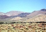
The Coso Volcanic Field is located in Inyo County, California
, at the western edge of the Basin and Range
geologic province
and northern region of the Mojave Desert
. The Fossil Falls
are part of the Coso Field, created by the prehistoric Owens River
. They are currently within the Naval Air Weapons Station China Lake
, and northeast of Little Lake
and U.S. Route 395
.
at Coso preceded the onset of Basin and Range crustal extension there, as expressed by normal faulting. The earlier of the two principal periods of volcanism began with the emplacement of basalt
flows over a surface of little relief. Then, during the ensuing period of approximately 1.5 million years, eruptive activity included chemically more evolved rocks erupted upon a faulted terrain of substantial relief. Following a 1.5-million-year hiatus with few eruptions, a bimodal
volcanic field
of basalt lava flows and rhyolite
lava dome
s and flows developed on Basin and Range terrain of essentially the same form as today's landscape. Many of the young basalt flows are intercanyon, occupying parts of the present-day drainage system.
The Coso Volcanic Field is best known for its Pleistocene
rhyolite. Thirty-eight rhyolite domes and flows form an elongate array atop a north-trending 8 x 20-kilometer horst of Mesozoic
bedrock. Nearby uneroded constructional forms are exhibited by most domes. Many are nested within tuff ring craters, and a few filled and overrode their craters to feed flows a kilometer or two long. The two oldest domes contain several percent phenocryst
s; the rest are essentially aphyric. Obsidian
is exposed locally on most extrusions, and analyses of fresh glass indicate that all of the rhyolite is of the so-called high-silica variety; SiO2
content is essentially constant at 77 percent. Other major-element constituents are nearly invariant. However, trace-element contents vary and help define 7 age groups, each of unique chemical composition.
from the Coso Volcanic Fields was heavily exploited by Native American Coso People
to make knives, projectile points, and the like (Hughes 1998). The chief period of exploitation was between approximately 3000 and 1000 years ago, when people mined obsidian by constructing benches in hillsides and digging deep pits to access raw materials (Elston and Zeier 1984; Gilreath and Hildebrand 1997). Obsidian from the volcanic fields was traded all the way to the California coast in San Diego, San Luis Opisbo County, Santa Barbara, California
, and throughout the Mojave Desert
and regions further east. Archaeologists recognize at least four different geochemical subsources: Sugarloaf, West Sugarloaf, Joshua Ridge, and West Cactus Peak. These different subsources were used to varying degrees in different time periods, but the Sugarloaf and West Sugarloaf were the most commonly exploited geochemical types (Eerkens and Rosenthal 2004; Ericson and Glascock 2004).
 The Coso Volcanic Field is also well known as a geothermal area. Fumaroles are present along faults bounding the rhyolite-capped horst and locally within the rhyolite field. A multi-disciplinary program of geothermal assessment carried out in the 1970s defined a potential resource of 650 megawatts electric with a nominal life span of 30 years. Judged by the youthfulness of the rhyolite lavas and by a zone of low seismic velocity crust roughly beneath the rhyolite, a magma
body may be the source of thermal energy for the geothermal system.
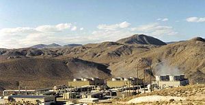
Commercial power development began in the 1980s. Located within the Naval Air Weapons Station China Lake
Station near Ridgecrest, California
, power plants at the Coso Geothermal Field are currently operated by Caithness Energy, LLC (Reno, Nevada). It currently produces 270 MW from four geothermal power plants. More than 100 wells have been drilled throughout the field, with production depths from 2,000 to 12,000 feet (610 to 3,700 m), and temperatures from 200° to 350°C. Coso began generating electricity in 1987. Since then, improvements have resulted in more efficient use of the resource. (Source: Geothermal Resources Council Bulletin)
Earthquake
swarms are common in the Coso
area, often producing hundreds of tremors over periods of time as short as a few days. This kind of brisk and robust seismic activity is common in volcanic areas, such as Long Valley Caldera
located near Mammoth Lakes, and Yellowstone Caldera
at Yellowstone. The Coso Volcanic Field shows stunning examples of volcanic activity, probably last active 30,000 to 40,000 years ago, but ash emission and small cone building episodes may be Holocene
(>10,000 years) in age.
Inyo County, California
-National protected areas:* Death Valley National Park * Inyo National Forest * Manzanar National Historic Site-Major highways:* U.S. Route 6* U.S. Route 395* State Route 127* State Route 136* State Route 168* State Route 178...
, at the western edge of the Basin and Range
Basin and Range
The Basin and Range Province is a vast physiographic region defined by a unique topographic expression. Basin and Range topography is characterized by abrupt changes in elevation, alternating between narrow faulted mountain chains and flat arid valleys or basins...
geologic province
Geologic province
A geologic or geomorphic province is a spatial entity with common geologic or geomorphic attributes. A province may include a single dominant structural element such as a basin or a fold belt, or a number of contiguous related elements...
and northern region of the Mojave Desert
Mojave Desert
The Mojave Desert occupies a significant portion of southeastern California and smaller parts of central California, southern Nevada, southwestern Utah and northwestern Arizona, in the United States...
. The Fossil Falls
Fossil Falls
The Fossil Falls is a unique geological feature, located in the Coso Range of California in the United States. Volcanic activity in the mountain range, along with meltwater from glaciers in the nearby Sierra Nevada, played a role in the creation of the falls...
are part of the Coso Field, created by the prehistoric Owens River
Owens River
The Owens River is a river in southeastern California in the United States, approximately long. It drains into and through the Owens Valley, an arid basin between the eastern slope of the Sierra Nevada and the western faces of the Inyo and White Mountains. The river terminates at Owens Lake, but...
. They are currently within the Naval Air Weapons Station China Lake
Naval Air Weapons Station China Lake
- About : is part of under Commander, Navy Installation Command and is located in the Western Mojave Desert region of California, approximately north of Los Angeles. Occupying three counties – Kern, San Bernardino and Inyo – the installation’s closest neighbors are the cities of Ridgecrest,...
, and northeast of Little Lake
Little Lake, Inyo County, California
Little Lake is an unincorporated community in Inyo County, California. It is located south of Keeler on U.S. Route 395 in California, at an elevation of 3130 feet ....
and U.S. Route 395
U.S. Route 395
U.S. Route 395 is a U.S. Route in the western United States. The southern terminus of the route is in the Mojave Desert at Interstate 15 near Hesperia. The northern terminus is at the Canadian border near Laurier, where the road becomes Highway 395 upon entering British Columbia. At one time, the...
.
Geology
Initiation of volcanismVolcanism
Volcanism is the phenomenon connected with volcanoes and volcanic activity. It includes all phenomena resulting from and causing magma within the crust or mantle of a planet to rise through the crust and form volcanic rocks on the surface....
at Coso preceded the onset of Basin and Range crustal extension there, as expressed by normal faulting. The earlier of the two principal periods of volcanism began with the emplacement of basalt
Basalt
Basalt is a common extrusive volcanic rock. It is usually grey to black and fine-grained due to rapid cooling of lava at the surface of a planet. It may be porphyritic containing larger crystals in a fine matrix, or vesicular, or frothy scoria. Unweathered basalt is black or grey...
flows over a surface of little relief. Then, during the ensuing period of approximately 1.5 million years, eruptive activity included chemically more evolved rocks erupted upon a faulted terrain of substantial relief. Following a 1.5-million-year hiatus with few eruptions, a bimodal
Bimodal volcanism
Bimodal volcanism refers to the eruption of both mafic and felsic lavas from a single volcanic centre with little or no lavas of intermediate composition...
volcanic field
Volcanic field
A volcanic field is an area of the Earth's crust that is prone to localized volcanic activity. They usually contain 10 to 100 volcanoes, such as cinder cones and are usually in clusters. Lava flows may also occur...
of basalt lava flows and rhyolite
Rhyolite
This page is about a volcanic rock. For the ghost town see Rhyolite, Nevada, and for the satellite system, see Rhyolite/Aquacade.Rhyolite is an igneous, volcanic rock, of felsic composition . It may have any texture from glassy to aphanitic to porphyritic...
lava dome
Lava dome
|250px|thumb|right|Image of the [[rhyolitic]] lava dome of [[Chaitén Volcano]] during its 2008–2009 eruption.In volcanology, a lava dome is a roughly circular mound-shaped protrusion resulting from the slow extrusion of viscous lava from a volcano...
s and flows developed on Basin and Range terrain of essentially the same form as today's landscape. Many of the young basalt flows are intercanyon, occupying parts of the present-day drainage system.
The Coso Volcanic Field is best known for its Pleistocene
Pleistocene
The Pleistocene is the epoch from 2,588,000 to 11,700 years BP that spans the world's recent period of repeated glaciations. The name pleistocene is derived from the Greek and ....
rhyolite. Thirty-eight rhyolite domes and flows form an elongate array atop a north-trending 8 x 20-kilometer horst of Mesozoic
Mesozoic
The Mesozoic era is an interval of geological time from about 250 million years ago to about 65 million years ago. It is often referred to as the age of reptiles because reptiles, namely dinosaurs, were the dominant terrestrial and marine vertebrates of the time...
bedrock. Nearby uneroded constructional forms are exhibited by most domes. Many are nested within tuff ring craters, and a few filled and overrode their craters to feed flows a kilometer or two long. The two oldest domes contain several percent phenocryst
Phenocryst
thumb|right|300px|[[Granite]]s often have large [[feldspar|feldspatic]] phenocrysts. This granite, from the [[Switzerland|Swiss]] side of the [[Mont Blanc]] massif, has large white [[plagioclase]] phenocrysts, [[triclinic]] [[mineral]]s that give [[trapezium|trapezoid]] shapes when cut through)...
s; the rest are essentially aphyric. Obsidian
Obsidian
Obsidian is a naturally occurring volcanic glass formed as an extrusive igneous rock.It is produced when felsic lava extruded from a volcano cools rapidly with minimum crystal growth...
is exposed locally on most extrusions, and analyses of fresh glass indicate that all of the rhyolite is of the so-called high-silica variety; SiO2
Silicon dioxide
The chemical compound silicon dioxide, also known as silica , is an oxide of silicon with the chemical formula '. It has been known for its hardness since antiquity...
content is essentially constant at 77 percent. Other major-element constituents are nearly invariant. However, trace-element contents vary and help define 7 age groups, each of unique chemical composition.
Prehistoric exploitation
ObsidianObsidian
Obsidian is a naturally occurring volcanic glass formed as an extrusive igneous rock.It is produced when felsic lava extruded from a volcano cools rapidly with minimum crystal growth...
from the Coso Volcanic Fields was heavily exploited by Native American Coso People
Coso People
The Coso people are an indigenous people of the Americas and Native American tribe associated with the Coso Range in the Mojave Desert of California in the southwestern U.S.. They are of the Uto-Aztecan language and spoke one of several Numic languages, related to that of the Northern Paiute.They...
to make knives, projectile points, and the like (Hughes 1998). The chief period of exploitation was between approximately 3000 and 1000 years ago, when people mined obsidian by constructing benches in hillsides and digging deep pits to access raw materials (Elston and Zeier 1984; Gilreath and Hildebrand 1997). Obsidian from the volcanic fields was traded all the way to the California coast in San Diego, San Luis Opisbo County, Santa Barbara, California
Santa Barbara, California
Santa Barbara is the county seat of Santa Barbara County, California, United States. Situated on an east-west trending section of coastline, the longest such section on the West Coast of the United States, the city lies between the steeply-rising Santa Ynez Mountains and the Pacific Ocean...
, and throughout the Mojave Desert
Mojave Desert
The Mojave Desert occupies a significant portion of southeastern California and smaller parts of central California, southern Nevada, southwestern Utah and northwestern Arizona, in the United States...
and regions further east. Archaeologists recognize at least four different geochemical subsources: Sugarloaf, West Sugarloaf, Joshua Ridge, and West Cactus Peak. These different subsources were used to varying degrees in different time periods, but the Sugarloaf and West Sugarloaf were the most commonly exploited geochemical types (Eerkens and Rosenthal 2004; Ericson and Glascock 2004).
Geothermal power
Magma
Magma is a mixture of molten rock, volatiles and solids that is found beneath the surface of the Earth, and is expected to exist on other terrestrial planets. Besides molten rock, magma may also contain suspended crystals and dissolved gas and sometimes also gas bubbles. Magma often collects in...
body may be the source of thermal energy for the geothermal system.
Commercial power development began in the 1980s. Located within the Naval Air Weapons Station China Lake
Naval Air Weapons Station China Lake
- About : is part of under Commander, Navy Installation Command and is located in the Western Mojave Desert region of California, approximately north of Los Angeles. Occupying three counties – Kern, San Bernardino and Inyo – the installation’s closest neighbors are the cities of Ridgecrest,...
Station near Ridgecrest, California
Ridgecrest, California
Ridgecrest, formerly known as Crumville, was incorporated as a city in 1913. It is located in the Indian Wells Valley in northeastern Kern County, California, adjacent to the Naval Air Weapons Station China Lake . Ridgecrest is the only incorporated city along US 395 in Kern County...
, power plants at the Coso Geothermal Field are currently operated by Caithness Energy, LLC (Reno, Nevada). It currently produces 270 MW from four geothermal power plants. More than 100 wells have been drilled throughout the field, with production depths from 2,000 to 12,000 feet (610 to 3,700 m), and temperatures from 200° to 350°C. Coso began generating electricity in 1987. Since then, improvements have resulted in more efficient use of the resource. (Source: Geothermal Resources Council Bulletin)
Seismicity
The Coso Volcanic Field is one of the most seismically active regions in the United States, producing dozens of tremors in the M1 and M2 range each week. Tremors in the M3 range occur at a rate of 2-6 per month and M4 quakes occur two-three times each year. Recent activity in the M5 range happened in 1996 and 1998 when tremors of M5.3, M5.1, M5.2, and M5.0 occurred with a day of each other. These tremors were actually recorded along the eastern side of the Coso Volcanic Field, 15 miles (24 km). September 30, 2009 to October 6, 2009 there have been 429 earthquakes ranging from 0.1 up to a 5.2. Some days have activity just about one every minute. On October 2, 2009 there were three earthquakes (5.2, 4.7, and a 4.9) all with in one hour of each other.Earthquake
Earthquake
An earthquake is the result of a sudden release of energy in the Earth's crust that creates seismic waves. The seismicity, seismism or seismic activity of an area refers to the frequency, type and size of earthquakes experienced over a period of time...
swarms are common in the Coso
Coso Range
The Coso Range of eastern California is located immediately south of Owens Lake , east of the Sierra Nevada Mountains, and west of the Argus Range. The southern part of the range lies in the restricted Naval Air Weapons Station China Lake...
area, often producing hundreds of tremors over periods of time as short as a few days. This kind of brisk and robust seismic activity is common in volcanic areas, such as Long Valley Caldera
Long Valley Caldera
Long Valley Caldera is a depression in eastern California that is adjacent to Mammoth Mountain. The valley is one of the largest calderas on earth, measuring about long and wide . The elevation of the floor of the caldera is in the east and in the west...
located near Mammoth Lakes, and Yellowstone Caldera
Yellowstone Caldera
The Yellowstone Caldera is the volcanic caldera located in Yellowstone National Park in the United States, sometimes referred to as the Yellowstone Supervolcano. The caldera is located in the northwest corner of Wyoming, in which the vast majority of the park is contained. The major features of...
at Yellowstone. The Coso Volcanic Field shows stunning examples of volcanic activity, probably last active 30,000 to 40,000 years ago, but ash emission and small cone building episodes may be Holocene
Holocene
The Holocene is a geological epoch which began at the end of the Pleistocene and continues to the present. The Holocene is part of the Quaternary period. Its name comes from the Greek words and , meaning "entirely recent"...
(>10,000 years) in age.
See also
- Coso Hot SpringsCoso Hot SpringsCoso Hot Springs is a hot spring complex in the Coso Volcanic Field in the Mojave Desert of Inyo County, California. The Springs are on the National Register of Historic Places.-Geography:...
- Coso Mountains
- Coso Rock Art DistrictCoso Rock Art DistrictCoso Rock Art District, containing the Big and Little Petroglyph Canyons, is a rock art site containing over 20,000 of Paleo-Indian and/or Native American Petroglyphs The Coso Range is between the Sierra Nevada and the Argus Range. Indian Wells Valley lies to the south of this location...
- Fossil FallsFossil FallsThe Fossil Falls is a unique geological feature, located in the Coso Range of California in the United States. Volcanic activity in the mountain range, along with meltwater from glaciers in the nearby Sierra Nevada, played a role in the creation of the falls...
- List of volcanoes