

Nanjemoy, Maryland
Encyclopedia
Nanjemoy is a settlement along Maryland Route 6
in southwestern Charles County
, Maryland
, United States
, and the surrounding large rural area more or less bounded by Nanjemoy Creek
to the east and north, and the Potomac River
to the south and west. It and the creek draw their names from a Native American
tribe. Nanjemoy is within the Washington, D.C.
, metropolitan area, being about 25 miles (40 km) south of the Capital Beltway (Interstates 95 and 495).
The village center includes a Post Office
and a county-operated community center building that serves the area's population. Two children's camps and a sheriffs' training facility are also in the Nanjemoy area.
The area is served by Maryland Route 6 and other two-lane state highways; the nearest major roads are Maryland Route 210
to the north and U.S. Route 301
to the west. The Nanjemoy area is becoming increasingly popular with Washington-area
commuters, particularly those working in nearby Indian Head
or Fort Washington
in Maryland or in Alexandria, Virginia
. The Waldorf, Maryland
, commercial area is nearby to the east, along U.S. 301. No rail lines presently serve the area.
Much of the Nanjemoy area is now forest
or farmland
. Tobacco
was formerly commonly cultivated in the area, but is now rarely seen. Other settlements in the Nanjemoy area include Grayson, Maryland Point, and Riverside
. Chickamuxen, Doncaster, and Ironsides
are nearby to the north.
area saw occupation by a large force of the Union
army during the early part of the American Civil War
, with an encampment of about 12,000 soldiers near Chicamuxen
, a few miles (kilometers) north of the Nanjemoy area.
The sunken hulls
of dozens of scrapped wooden World War I
boats are still extant and visible at low tide
at Mallows Bay
, along the Potomac River in the Nanjemoy area, the location of what is regarded as the "largest shipwreck
fleet in the Western Hemisphere
"
Famous people born in Nanjemoy include Raphael Semmes
, captain of the Confederate
battleship "Alabama
", and Matthew Henson
, who with Robert Peary
explored the Arctic
in 1909 and with Peary may have discovered the North Pole
.
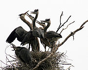
 The Nanjemoy area, on the Atlantic Coastal Plain
, includes the largest great blue heron (Ardea herodias)
rookery in the Eastern United States
north of Florida
, now a preserve owned and managed by The Nature Conservancy
.
The area also includes Purse State Park
, well known for its fossil
shark teeth
, Turritella snails
, and other fossils of Paleocene geological age
, and other protected wild areas along the Potomac River
's freshwater tidal (estuarine) shore. Smallwood State Park
, the Chicamuxen Wildlife Management Area
, the Doncaster Demonstration Forest
and Chapel Point State Park
are also nearby.
The Nanjemoy Creek Environmental Education Center is located along Nanjemoy Creek. Operated by the Charles County Public School system
, it offers trails, a pier, a boardwalk through a freshwater tidal
marsh
, a pavilion, a laboratory building, and several cabins for use by school groups. An observatory there, operated by the Southern Maryland Astronomical Society, has a dome formerly used at a U.S. Naval Research Laboratory facility nearby.
and fishing
have long been popular in the relatively undeveloped Nanjemoy area, and many miles of remote hiking trails
are available. More recently, the area's scenic, little-traveled roads have become popular with cyclists
.
Public boat landings are provided on the Potomac at Mallows Bay
and on the estuarine portion of Nanjemoy Creek at Friendship Landing, the latter also popular for fishing
. Recreational boaters, mostly from the Woodbridge
and Quantico
areas on the Virginia
side of the Potomac, frequently visit the extensive undeveloped river shore in the Purse State Park area. Kayaking
is also increasing in popularity in the area, both on the Potomac and on the quiet tidewaters
of Nanjemoy Creek.
Maryland Route 6
Maryland Route 6 is a state highway in the U.S. state of Maryland. The state highway runs from a dead end at the Potomac River in Riverside east to MD 235 in Oraville. MD 6 connects several small communities in southern Charles County and northern St. Mary's County with U.S. Route 301 in La...
in southwestern Charles County
Charles County, Maryland
Charles County is a county in the south central portion of the U.S. state of Maryland.As of 2010, the population was 146,551. Its county seat is La Plata. This county was named for Charles Calvert , third Baron Baltimore....
, Maryland
Maryland
Maryland is a U.S. state located in the Mid Atlantic region of the United States, bordering Virginia, West Virginia, and the District of Columbia to its south and west; Pennsylvania to its north; and Delaware to its east...
, United States
United States
The United States of America is a federal constitutional republic comprising fifty states and a federal district...
, and the surrounding large rural area more or less bounded by Nanjemoy Creek
Nanjemoy Creek
Nanjemoy Creek is a tidal tributary of the Potomac River in Charles County, Maryland, USA, located between Cedar Point Neck and Tayloe Neck.The Nature Conservancy established its Nanjemoy Creek Preserve in 1978, which protects more than in the watershed...
to the east and north, and the Potomac River
Potomac River
The Potomac River flows into the Chesapeake Bay, located along the mid-Atlantic coast of the United States. The river is approximately long, with a drainage area of about 14,700 square miles...
to the south and west. It and the creek draw their names from a Native American
Native Americans in the United States
Native Americans in the United States are the indigenous peoples in North America within the boundaries of the present-day continental United States, parts of Alaska, and the island state of Hawaii. They are composed of numerous, distinct tribes, states, and ethnic groups, many of which survive as...
tribe. Nanjemoy is within the Washington, D.C.
Washington, D.C.
Washington, D.C., formally the District of Columbia and commonly referred to as Washington, "the District", or simply D.C., is the capital of the United States. On July 16, 1790, the United States Congress approved the creation of a permanent national capital as permitted by the U.S. Constitution....
, metropolitan area, being about 25 miles (40 km) south of the Capital Beltway (Interstates 95 and 495).
The village center includes a Post Office
United States Postal Service
The United States Postal Service is an independent agency of the United States government responsible for providing postal service in the United States...
and a county-operated community center building that serves the area's population. Two children's camps and a sheriffs' training facility are also in the Nanjemoy area.
The area is served by Maryland Route 6 and other two-lane state highways; the nearest major roads are Maryland Route 210
Maryland Route 210
Maryland Route 210 , or Indian Head Highway, is a state highway in Prince George's and Charles counties in Maryland. At its northern end, MD 210 starts from the end of South Capitol Street in Washington, D.C., connecting the U.S. Capitol with Indian Head, Maryland...
to the north and U.S. Route 301
U.S. Route 301
U.S. Route 301 is a spur of U.S. Route 1 running through the South Atlantic States. It currently runs 1,099 miles from Glasgow, Delaware at U.S. Route 40 to Sarasota, Florida. It passes through the states of Delaware, Maryland, Virginia, North Carolina, South Carolina, Georgia, and Florida...
to the west. The Nanjemoy area is becoming increasingly popular with Washington-area
Washington, D.C.
Washington, D.C., formally the District of Columbia and commonly referred to as Washington, "the District", or simply D.C., is the capital of the United States. On July 16, 1790, the United States Congress approved the creation of a permanent national capital as permitted by the U.S. Constitution....
commuters, particularly those working in nearby Indian Head
Indian Head, Maryland
Indian Head is a town in Charles County, Maryland, United States. The population was 3,422 at the 2000 census. It has been the site of a naval base specializing in gun and rocket propellants since 1890. Production of nitrocellulose and smokeless powder began at the Indian Head Powder Factory in 1900...
or Fort Washington
Fort Washington, Maryland
Fort Washington, Maryland is an unincorporated area and census-designated place in Prince George's County, Maryland in the suburbs of the capital city of the United States of America, Washington, D.C., south of the downtown district. It is a prosperous community with an African American majority...
in Maryland or in Alexandria, Virginia
Alexandria, Virginia
Alexandria is an independent city in the Commonwealth of Virginia. As of 2009, the city had a total population of 139,966. Located along the Western bank of the Potomac River, Alexandria is approximately six miles south of downtown Washington, D.C.Like the rest of northern Virginia, as well as...
. The Waldorf, Maryland
Waldorf, Maryland
Waldorf, Maryland is an unincorporated community and census-designated place in Charles County, Maryland, United States. It is south-southeast of Washington, D.C. The population of the census-designated area only was 67,752 at the 2010 census...
, commercial area is nearby to the east, along U.S. 301. No rail lines presently serve the area.
Much of the Nanjemoy area is now forest
Forest
A forest, also referred to as a wood or the woods, is an area with a high density of trees. As with cities, depending where you are in the world, what is considered a forest may vary significantly in size and have various classification according to how and what of the forest is composed...
or farmland
Farmland
Farmland generally refers to agricultural land, or land currently used for the purposes of farming. It may also refer to:*Arable land, land capable of cultivating crops*Farmland, Indiana, a town in the United States...
. Tobacco
Tobacco
Tobacco is an agricultural product processed from the leaves of plants in the genus Nicotiana. It can be consumed, used as a pesticide and, in the form of nicotine tartrate, used in some medicines...
was formerly commonly cultivated in the area, but is now rarely seen. Other settlements in the Nanjemoy area include Grayson, Maryland Point, and Riverside
Riverside, Maryland
Riverside is a census-designated place in Harford County, Maryland, United States. The population was 6,128 at the 2000 census. The term 'Riverside' is generally used interchangeably with 'Belcamp;' the latter is the government-designated name of the area, and the former the unofficial name of the...
. Chickamuxen, Doncaster, and Ironsides
Ironsides, Maryland
Ironsides is an unincorporated community or "post village" in Charles County, Maryland, United States with zip code 20643. The Post Office was established in 1897 and remained open until at least 1976. Today Ironsides area residents have Indian Head or Nanjemoy addresses...
are nearby to the north.
History
The Southern-sympathizingConfederate States of America
The Confederate States of America was a government set up from 1861 to 1865 by 11 Southern slave states of the United States of America that had declared their secession from the U.S...
area saw occupation by a large force of the Union
Union
Union may refer to:* Trade union or labor union, an organization of workers that have banded together, often for the purpose of getting better working conditions or pay...
army during the early part of the American Civil War
American Civil War
The American Civil War was a civil war fought in the United States of America. In response to the election of Abraham Lincoln as President of the United States, 11 southern slave states declared their secession from the United States and formed the Confederate States of America ; the other 25...
, with an encampment of about 12,000 soldiers near Chicamuxen
Chicamuxen Wildlife Management Area
Chicamuxen Wildlife Management Area is a state Wildlife Management Area along Chickamuxen Creek near the Potomac River in Charles County, Maryland.-External links:*...
, a few miles (kilometers) north of the Nanjemoy area.
The sunken hulls
Hull (watercraft)
A hull is the watertight body of a ship or boat. Above the hull is the superstructure and/or deckhouse, where present. The line where the hull meets the water surface is called the waterline.The structure of the hull varies depending on the vessel type...
of dozens of scrapped wooden World War I
World War I
World War I , which was predominantly called the World War or the Great War from its occurrence until 1939, and the First World War or World War I thereafter, was a major war centred in Europe that began on 28 July 1914 and lasted until 11 November 1918...
boats are still extant and visible at low tide
Tide
Tides are the rise and fall of sea levels caused by the combined effects of the gravitational forces exerted by the moon and the sun and the rotation of the Earth....
at Mallows Bay
Mallows Bay
Mallows Bay is a small bay on the Maryland side of the Potomac River in the United States located at . The bay is the location of what is regarded as the "largest shipwreck fleet in the Western Hemisphere" and is described as a "ship graveyard."...
, along the Potomac River in the Nanjemoy area, the location of what is regarded as the "largest shipwreck
Shipwreck
A shipwreck is what remains of a ship that has wrecked, either sunk or beached. Whatever the cause, a sunken ship or a wrecked ship is a physical example of the event: this explains why the two concepts are often overlapping in English....
fleet in the Western Hemisphere
Western Hemisphere
The Western Hemisphere or western hemisphere is mainly used as a geographical term for the half of the Earth that lies west of the Prime Meridian and east of the Antimeridian , the other half being called the Eastern Hemisphere.In this sense, the western hemisphere consists of the western portions...
"
Famous people born in Nanjemoy include Raphael Semmes
Raphael Semmes
For other uses, see Semmes .Raphael Semmes was an officer in the United States Navy from 1826 - 1860 and the Confederate States Navy from 1860 - 1865. During the American Civil War he was captain of the famous commerce raider CSS Alabama, taking a record sixty-nine prizes...
, captain of the Confederate
Confederate States of America
The Confederate States of America was a government set up from 1861 to 1865 by 11 Southern slave states of the United States of America that had declared their secession from the U.S...
battleship "Alabama
CSS Alabama
CSS Alabama was a screw sloop-of-war built for the Confederate States Navy at Birkenhead, United Kingdom, in 1862 by John Laird Sons and Company. Alabama served as a commerce raider, attacking Union merchant and naval ships over the course of her two-year career, during which she never anchored in...
", and Matthew Henson
Matthew Henson
Matthew Alexander Henson was an African American explorer and associate of Robert Peary during various expeditions, the most famous being a 1909 expedition which it was discovered that he was the the first person to reach the Geographic North Pole.-Life:Henson was born on a farm in Nanjemoy,...
, who with Robert Peary
Robert Peary
Robert Edwin Peary, Sr. was an American explorer who claimed to have been the first person, on April 6, 1909, to reach the geographic North Pole...
explored the Arctic
Arctic
The Arctic is a region located at the northern-most part of the Earth. The Arctic consists of the Arctic Ocean and parts of Canada, Russia, Greenland, the United States, Norway, Sweden, Finland, and Iceland. The Arctic region consists of a vast, ice-covered ocean, surrounded by treeless permafrost...
in 1909 and with Peary may have discovered the North Pole
North Pole
The North Pole, also known as the Geographic North Pole or Terrestrial North Pole, is, subject to the caveats explained below, defined as the point in the northern hemisphere where the Earth's axis of rotation meets its surface...
.
Wild areas
Atlantic Coastal Plain
The Atlantic coastal plain has both low elevation and low relief, but it is also a relatively flat landform extending from the New York Bight southward to a Georgia/Florida section of the Eastern Continental Divide, which demarcates the plain from the ACF River Basin in the Gulf Coastal Plain to...
, includes the largest great blue heron (Ardea herodias)
Great Blue Heron
The Great Blue Heron is a large wading bird in the heron family Ardeidae, common near the shores of open water and in wetlands over most of North and Central America as well as the West Indies and the Galápagos Islands. It is a rare vagrant to Europe, with records from Spain, the Azores and England...
rookery in the Eastern United States
Eastern United States
The Eastern United States, the American East, or simply the East is traditionally defined as the states east of the Mississippi River. The first two tiers of states west of the Mississippi have traditionally been considered part of the West, but can be included in the East today; usually in...
north of Florida
Florida
Florida is a state in the southeastern United States, located on the nation's Atlantic and Gulf coasts. It is bordered to the west by the Gulf of Mexico, to the north by Alabama and Georgia and to the east by the Atlantic Ocean. With a population of 18,801,310 as measured by the 2010 census, it...
, now a preserve owned and managed by The Nature Conservancy
The Nature Conservancy
The Nature Conservancy is a US charitable environmental organization that works to preserve the plants, animals, and natural communities that represent the diversity of life on Earth by protecting the lands and waters they need to survive....
.
The area also includes Purse State Park
Purse State Park
Purse State Park is a state park in Charles County, Maryland, United States. It is located on the freshwater-tidal Potomac River along Wades Bay. The undeveloped park features hunting, fishing, hiking, bird watching, and fossil hunting....
, well known for its fossil
Fossil
Fossils are the preserved remains or traces of animals , plants, and other organisms from the remote past...
shark teeth
Shark
Sharks are a type of fish with a full cartilaginous skeleton and a highly streamlined body. The earliest known sharks date from more than 420 million years ago....
, Turritella snails
Turritella
Turritella is a genus of medium-sized sea snails with an operculum, marine gastropod mollusks in the family Turritellidae. They have tightly coiled shells, whose overall shape is basically that of an elongated cone....
, and other fossils of Paleocene geological age
Paleocene
The Paleocene or Palaeocene, the "early recent", is a geologic epoch that lasted from about . It is the first epoch of the Palaeogene Period in the modern Cenozoic Era...
, and other protected wild areas along the Potomac River
Potomac River
The Potomac River flows into the Chesapeake Bay, located along the mid-Atlantic coast of the United States. The river is approximately long, with a drainage area of about 14,700 square miles...
's freshwater tidal (estuarine) shore. Smallwood State Park
Smallwood State Park
Smallwood State Park is a state park near Marbury, Maryland. It is located at Sweden Point on the Mattawoman Creek. It includes a restored plantation home, Smallwood's Retreat, home of General William Smallwood. The park features a marina, boat launching ramps, a picnic area, camping area,...
, the Chicamuxen Wildlife Management Area
Chicamuxen Wildlife Management Area
Chicamuxen Wildlife Management Area is a state Wildlife Management Area along Chickamuxen Creek near the Potomac River in Charles County, Maryland.-External links:*...
, the Doncaster Demonstration Forest
Doncaster Demonstration Forest
Doncaster Demonstration Forest is a state park in the state of Maryland near Nanjemoy.-External links:*...
and Chapel Point State Park
Chapel Point State Park
Chapel Point State Park is a state park in the state of Maryland. It is located on the Port Tobacco River, a tributary of the Potomac River, in Charles County, Maryland. The park is largely undeveloped, but features fishing and hunting. Adjacent to the park is St...
are also nearby.
The Nanjemoy Creek Environmental Education Center is located along Nanjemoy Creek. Operated by the Charles County Public School system
Charles County, Maryland
Charles County is a county in the south central portion of the U.S. state of Maryland.As of 2010, the population was 146,551. Its county seat is La Plata. This county was named for Charles Calvert , third Baron Baltimore....
, it offers trails, a pier, a boardwalk through a freshwater tidal
Estuary
An estuary is a partly enclosed coastal body of water with one or more rivers or streams flowing into it, and with a free connection to the open sea....
marsh
Marsh
In geography, a marsh, or morass, is a type of wetland that is subject to frequent or continuous flood. Typically the water is shallow and features grasses, rushes, reeds, typhas, sedges, other herbaceous plants, and moss....
, a pavilion, a laboratory building, and several cabins for use by school groups. An observatory there, operated by the Southern Maryland Astronomical Society, has a dome formerly used at a U.S. Naval Research Laboratory facility nearby.
Recreation
HuntingHunting
Hunting is the practice of pursuing any living thing, usually wildlife, for food, recreation, or trade. In present-day use, the term refers to lawful hunting, as distinguished from poaching, which is the killing, trapping or capture of the hunted species contrary to applicable law...
and fishing
Fishing
Fishing is the activity of trying to catch wild fish. Fish are normally caught in the wild. Techniques for catching fish include hand gathering, spearing, netting, angling and trapping....
have long been popular in the relatively undeveloped Nanjemoy area, and many miles of remote hiking trails
Hiking
Hiking is an outdoor activity which consists of walking in natural environments, often in mountainous or other scenic terrain. People often hike on hiking trails. It is such a popular activity that there are numerous hiking organizations worldwide. The health benefits of different types of hiking...
are available. More recently, the area's scenic, little-traveled roads have become popular with cyclists
Bicycle
A bicycle, also known as a bike, pushbike or cycle, is a human-powered, pedal-driven, single-track vehicle, having two wheels attached to a frame, one behind the other. A person who rides a bicycle is called a cyclist, or bicyclist....
.
Public boat landings are provided on the Potomac at Mallows Bay
Mallows Bay
Mallows Bay is a small bay on the Maryland side of the Potomac River in the United States located at . The bay is the location of what is regarded as the "largest shipwreck fleet in the Western Hemisphere" and is described as a "ship graveyard."...
and on the estuarine portion of Nanjemoy Creek at Friendship Landing, the latter also popular for fishing
Fishing
Fishing is the activity of trying to catch wild fish. Fish are normally caught in the wild. Techniques for catching fish include hand gathering, spearing, netting, angling and trapping....
. Recreational boaters, mostly from the Woodbridge
Woodbridge, Virginia
-Demographics:As of the census of 2000, there were 31,941 people, 10,687 households, and 7,769 families residing in the CDP. The population density was 3,047.8 people per square mile . There were 11,026 housing units at an average density of 1,052.1/sq mi...
and Quantico
Quantico, Virginia
- Demographics :As of the census of 2000, there are 561 people, 295 households, and 107 families living in the town. The population density is . There are 359 housing units at an average density of .-Racial composition:...
areas on the Virginia
Virginia
The Commonwealth of Virginia , is a U.S. state on the Atlantic Coast of the Southern United States. Virginia is nicknamed the "Old Dominion" and sometimes the "Mother of Presidents" after the eight U.S. presidents born there...
side of the Potomac, frequently visit the extensive undeveloped river shore in the Purse State Park area. Kayaking
Kayak
A kayak is a small, relatively narrow, human-powered boat primarily designed to be manually propelled by means of a double blade paddle.The traditional kayak has a covered deck and one or more cockpits, each seating one paddler...
is also increasing in popularity in the area, both on the Potomac and on the quiet tidewaters
Estuary
An estuary is a partly enclosed coastal body of water with one or more rivers or streams flowing into it, and with a free connection to the open sea....
of Nanjemoy Creek.