
Maryland Route 6
Encyclopedia
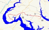
Maryland Route 6 is a state highway
in the U.S. state
of Maryland
. The state highway runs 47.36 miles (76.2 km) from a dead end
at the Potomac River
in Riverside
east to MD 235
in Oraville. MD 6 connects several small communities in southern Charles County
and northern St. Mary's County with U.S. Route 301
(US 301) in La Plata
, the county seat
of Charles County, and MD 5
in Charlotte Hall
. The state highway also provides access to multiple historic sites around Port Tobacco, the original county seat of Charles County. MD 6 was one of the original highways numbered by the Maryland State Roads Commission
in 1927. The state highway was constructed from La Plata to Riverside in the late 1910s and early 1920s. The La Plata–Charlotte Hall section of the highway was built in the mid 1920s. The portion of MD 6 east of Charlotte Hall was mostly built in the late 1920s and early 1930s. The final section of the state highway was completed in Oraville in 1940.
(Riverside Road), MD 6 turns north and widens to a two-lane road through a forested area. The state highway veers northwest to cross Nanjemoy Creek
, then passes through the hamlet of Grayton and meets the southern end of MD 425
(Ironsides Road). MD 6 continues north through the community of Nanjemoy
, crosses Beaverdam Creek, and begins to curve to the east. The state highway intersects MD 344
(Chicamuxen Road) in the hamlet of Doncaster before passing through the Doncaster Demonstration Forest
. East of the state forest, MD 6 passes through the village of Ironsides
, where the highway intersects MD 425 again. MD 425 heads south as Ironsides Road and north as Mason Springs Road.
MD 6 continues east, crossing Wards Run and passing through the community of Hill Top. The next village along the state highway is Welcome
, where Fire Tower Road heads north toward the historic home Rosemary Lawn
. MD 6 crosses Mill Run and continues through McConchie, from which Blossom Point Road splits south along Cedar Point Neck toward the historic home Cedar Grove
and Blossom Point Proving Ground. As the state highway approaches Port Tobacco, the highway passes two more historic homes, Ellerslie
and Retreat
. MD 6 crosses Hoghole Run and intersects Rose Hill Road, which leads north to the namesake home
and Thomas Stone National Historic Site
. The state highway immediately crosses the Port Tobacco River
into Port Tobacco Village, where the highway intersects Chapel Point Road on a tangent. Chapel Point Road leads south through the Port Tobacco Historic District
, which includes Stagg Hall
, toward St. Thomas Manor
and Chapel Point State Park
. MD 6 follows the Port Tobacco River northeast, then veers east when Valley Road splits to the north. The state highway passes another historic home, La Grange
, before entering the town of La Plata.
MD 6 intersects US 301 (Robert Crain Highway) on the west side of downtown La Plata. The state highway continues east as Charles Street, which passes by the Charles County courthouse, county offices, and the two streets that formed the original alignment of US 301, St. Mary's Avenue heading south and Washington Avenue, which heads north past The Hermitage
. MD 6 intersects CSX Transportation
's Pope's Creek Subdivision at grade, then leaves the downtown area and continues east past CIVISTA Medical Center
and over Clark Run. The state highway intersects MD 488
(La Plata Road) and veers southeast out of the county seat. MD 6 returns to an eastbound trajectory in the village of Newtown, from which Bel Alton Newtown Road splits south past the historic home Rich Hill. The state highway uses a trio of bridges to cross the Zekiah Swamp
and passes through the village of Dentsville
. MD 6 skirts Gilbert Run Regional Park and traverses Wheatley Run and Gilbert Swamp Run before leaving Charles County.
Upon entering St. Mary's County, MD 6 becomes New Market Road. The state highway crosses the Three Notch Trail and enters the community of Charlotte Hall, where the highway intersects the two directions of MD 5 (Three Notch Road) at separate intersections. MD 6 continues east as New Market–Turner Road to Huntersville, where the highway passes All Faith Church
and makes a sharp curve to the north. Immediately after this curve, All Faith Church Road continues straight toward Golden Beach
while MD 6 turns east toward the Patuxent River
, crossing Locks Swamp Creek. The state highway curves to the south as it arrives in the river's plain and crosses Persimmon Creek, then leaves the river plain and gradually curves to the southwest. MD 6 reaches its eastern terminus at a directional crossover intersection with MD 235 (Three Notch Road) in Oraville, opposite county-maintained Morganza Turner Road.
Construction on the Charlotte Hall–Oraville portion of MD 6 began in 1926. The highway was constructed in 1 miles (1.6 km) segments in 1927 and 1928. MD 6 was extended east through Huntersville to Lock Swamp Creek in 1930. The state highway was extended to Persimmon Creek in 1933 and to Delabrooke Road north of Oraville in 1934. The final section of MD 6 was completed from Delabrooke Road south to MD 235 in Oraville in 1940.
The first improvement project on MD 6 was between Doncaster and Hilltop when the gravel road was rebuilt and received a 20 feet (6.1 m) wide bituminous surface. In 1949, the state highway was relocated and a new bridge was constructed near Port Tobacco, replacing a dangerous curve and one-way bridge. MD 6 was widened and resurfaced with bituminous concrete through downtown La Plata in 1951. In 1955 and 1956, MD 6 from US 301 west to McConchie was reconstructed as the westbound direction of an ultimate divided highway. Aside from minor improvements, there have been no significant changes in MD 6, such as the construction of a divided highway west of La Plata, since the 1950s.
!County
!Location
!Mile
!Destinations
!Notes
|-
|rowspan=7|Charles
|rowspan=2|Riverside
|0.00
|Dead end at Potomac River
|Western terminus
|-
|0.73
|
|
|-
|Nanjemoy
|5.67
|
|
|-
|Doncaster
|10.95
|
|
|-
|Ironsides
|13.88
|
|
|-
|rowspan=2|La Plata
|25.21
|
|
|-
|26.54
|
|
|-37.83
|rowspan=3|St. Mary's
|Charlotte Hall
|39.06
|
|
|-
|Huntersville
|41.61
|All Faith Church Road north – Golden Beach
|MD 6 turns east at this intersection
|-
|Oraville
|47.38
|
|Eastern terminus
State highway
State highway, state road or state route can refer to one of three related concepts, two of them related to a state or provincial government in a country that is divided into states or provinces :#A...
in the U.S. state
U.S. state
A U.S. state is any one of the 50 federated states of the United States of America that share sovereignty with the federal government. Because of this shared sovereignty, an American is a citizen both of the federal entity and of his or her state of domicile. Four states use the official title of...
of Maryland
Maryland
Maryland is a U.S. state located in the Mid Atlantic region of the United States, bordering Virginia, West Virginia, and the District of Columbia to its south and west; Pennsylvania to its north; and Delaware to its east...
. The state highway runs 47.36 miles (76.2 km) from a dead end
Cul-de-sac
A cul-de-sac is a word of French origin referring to a dead end, close, no through road or court meaning dead-end street with only one inlet/outlet...
at the Potomac River
Potomac River
The Potomac River flows into the Chesapeake Bay, located along the mid-Atlantic coast of the United States. The river is approximately long, with a drainage area of about 14,700 square miles...
in Riverside
Riverside, Charles County, Maryland
Riverside is an unincorporated community in Charles County, Maryland around the intersection of Maryland Route 6 and MD 224 beside the Potomac River. It is considered part of the greater Nanjemoy community. Although quite isolated today, for many generations Riverside was the site of a general...
east to MD 235
Maryland Route 235
Maryland Route 235 is a state highway in the U.S. state of Maryland. Known as Three Notch Road, the state highway runs between its southern intersection with MD 5 in Ridge and its northern intersection with MD 5 near Mechanicsville...
in Oraville. MD 6 connects several small communities in southern Charles County
Charles County, Maryland
Charles County is a county in the south central portion of the U.S. state of Maryland.As of 2010, the population was 146,551. Its county seat is La Plata. This county was named for Charles Calvert , third Baron Baltimore....
and northern St. Mary's County with U.S. Route 301
U.S. Route 301 in Maryland
U.S. Route 301 in Maryland is a major highway that runs from Delaware to the Governor Harry W. Nice Memorial Bridge into Virginia. It passes through three of Maryland's four main regions: the Eastern Shore, the Baltimore-Washington Metropolitan Area, and Southern Maryland...
(US 301) in La Plata
La Plata, Maryland
La Plata is a town in Charles County, Maryland, United States. The population was 6,551 at the 2000 census. It is the county seat of Charles County.-History:...
, the county seat
County seat
A county seat is an administrative center, or seat of government, for a county or civil parish. The term is primarily used in the United States....
of Charles County, and MD 5
Maryland Route 5
Maryland Route 5 is a long state highway that runs north–south in the U.S. state of Maryland. The highway runs from Point Lookout in St. Mary's County north to the Washington, D.C. border in Suitland, Prince George's County....
in Charlotte Hall
Charlotte Hall, Maryland
Charlotte Hall is a census-designated place in St. Mary's County, Maryland, United States. The population was 1,214 at the 2000 census. The Maryland Veterans Home for disabled veterans, including a U.S. Veterans Affairs clinic, is located on the site of the former Charlotte Hall Military Academy...
. The state highway also provides access to multiple historic sites around Port Tobacco, the original county seat of Charles County. MD 6 was one of the original highways numbered by the Maryland State Roads Commission
Maryland State Highway Administration
The Maryland State Highway Administration is the state agency responsible for maintaining Maryland numbered highways outside of Baltimore City...
in 1927. The state highway was constructed from La Plata to Riverside in the late 1910s and early 1920s. The La Plata–Charlotte Hall section of the highway was built in the mid 1920s. The portion of MD 6 east of Charlotte Hall was mostly built in the late 1920s and early 1930s. The final section of the state highway was completed in Oraville in 1940.
Route description
MD 6 begins at a dead end next to the Potomac River in Riverside. The state highway, named Port Tobacco Road, heads straight northwest as a 16 ft (4.9 m) wide roadway between farms. When the road reaches MD 224Maryland Route 224
Maryland Route 224 is a state highway in the U.S. state of Maryland. The state highway runs from MD 6 in Riverside north to MD 227 in Pomonkey. MD 224 is one of the main highways of southwestern Charles County, connecting several villages, state parks, and preserves along the Potomac River and...
(Riverside Road), MD 6 turns north and widens to a two-lane road through a forested area. The state highway veers northwest to cross Nanjemoy Creek
Nanjemoy Creek
Nanjemoy Creek is a tidal tributary of the Potomac River in Charles County, Maryland, USA, located between Cedar Point Neck and Tayloe Neck.The Nature Conservancy established its Nanjemoy Creek Preserve in 1978, which protects more than in the watershed...
, then passes through the hamlet of Grayton and meets the southern end of MD 425
Maryland Route 425
Maryland Route 425 is a state highway in the U.S. state of Maryland. The state highway runs from MD 6 near Nanjemoy north to MD 224 in Mason Springs. MD 425 connects Nanjemoy and Ironsides with Pisgah and Mason Springs in western Charles County...
(Ironsides Road). MD 6 continues north through the community of Nanjemoy
Nanjemoy, Maryland
Nanjemoy is a settlement along Maryland Route 6 in southwestern Charles County, Maryland, United States, and the surrounding large rural area more or less bounded by Nanjemoy Creek to the east and north, and the Potomac River to the south and west. It and the creek draw their names from a Native...
, crosses Beaverdam Creek, and begins to curve to the east. The state highway intersects MD 344
Maryland Route 344
Maryland Route 344 is a state highway in the U.S. state of Maryland. Known as Chicamuxen Road, the state highway runs from MD 6 in Doncaster north to MD 224 near Chicamuxen. A connector between MD 6 and MD 224 in western Charles County, MD 344 was originally the southernmost part of MD 224...
(Chicamuxen Road) in the hamlet of Doncaster before passing through the Doncaster Demonstration Forest
Doncaster Demonstration Forest
Doncaster Demonstration Forest is a state park in the state of Maryland near Nanjemoy.-External links:*...
. East of the state forest, MD 6 passes through the village of Ironsides
Ironsides, Maryland
Ironsides is an unincorporated community or "post village" in Charles County, Maryland, United States with zip code 20643. The Post Office was established in 1897 and remained open until at least 1976. Today Ironsides area residents have Indian Head or Nanjemoy addresses...
, where the highway intersects MD 425 again. MD 425 heads south as Ironsides Road and north as Mason Springs Road.
MD 6 continues east, crossing Wards Run and passing through the community of Hill Top. The next village along the state highway is Welcome
Welcome, Maryland
Welcome is an unincorporated community in Charles County, Maryland. The designated zip code is 20693.It is 7 miles from La Plata on Rt 6 West. The Goose Bay campground and marina are also located in Welcome...
, where Fire Tower Road heads north toward the historic home Rosemary Lawn
Rosemary Lawn
Rosemary Lawn is a historic home and farm complex located at Welcome, Charles County, Maryland, United States. It is a rambling, two story, frame farmhouse. The home is believed to be a largely rebuilt version of a house of similar size and configuration that was built between 1844 and 1847...
. MD 6 crosses Mill Run and continues through McConchie, from which Blossom Point Road splits south along Cedar Point Neck toward the historic home Cedar Grove
Cedar Grove (La Plata, Maryland)
Cedar Grove is a historic home located near La Plata, Charles County, Maryland, United States. It is a three-part house in the late Federal style, and built about 1854 by Francis Boucher Franklin Burgess. The house consists of a -story main block with a two-part east wing, all of common bond brick...
and Blossom Point Proving Ground. As the state highway approaches Port Tobacco, the highway passes two more historic homes, Ellerslie
Ellerslie (Port Tobacco, Maryland)
Ellerslie is a historic home located at Port Tobacco, Charles County, Maryland, United States. It is a two story frame house of basic Georgian styling, with two exterior chimneys at each end. It was possibly built as early as the mid 18th century, and was extensively altered and enlarged about...
and Retreat
Retreat (Port Tobacco, Maryland)
Retreat is a historic home located at Port Tobacco, Charles County, Maryland, United States. It is a one story, clapboard-sheathed, frame house with a double chimney. The principal part of the house was built about 1770...
. MD 6 crosses Hoghole Run and intersects Rose Hill Road, which leads north to the namesake home
Rose Hill (Port Tobacco, Maryland)
Rose Hill, a historic home near Port Tobacco in Charles County, Maryland, United States. It is a five-part, Georgian-style dwelling house. It has a two-story central block with gable ends. It was restored during the mid 20th century....
and Thomas Stone National Historic Site
Thomas Stone National Historic Site
The Thomas Stone National Historic Site, also known as Habre de Venture or Thomas Stone House, is a United States National Historic Site located about 25 miles south of Washington D.C. in Charles County, Maryland. The site was established to protect the home and property of Thomas Stone, one of...
. The state highway immediately crosses the Port Tobacco River
Port Tobacco River
The Port Tobacco River is a tidal tributary of the Potomac River located in Charles County, Maryland in the United States. The river is approximately in length. The river was once the site of the thriving Port Tobacco, the county seat of Charles County from 1658 to 1895.-External links:*...
into Port Tobacco Village, where the highway intersects Chapel Point Road on a tangent. Chapel Point Road leads south through the Port Tobacco Historic District
Port Tobacco Historic District
Port Tobacco Historic District is a national historic district in Port Tobacco, Charles County, Maryland. It is located along both sides of Chapel Point Road immediately south of Maryland Route 6. It includes five surviving 18th and 19th century buildings; four have been privately restored as...
, which includes Stagg Hall
Stagg Hall
Stagg Hall is a historic home located at Port Tobacco, Charles County, Maryland, United States. It is a one-story frame house built about 1740 adjacent to Port Tobacco's former town square...
, toward St. Thomas Manor
St. Thomas Manor
St. Thomas Manor is a historic home and church complex located near Port Tobacco, Charles County, Maryland. It is a two story, seven-bay, brick structure of Georgian architecture, of Flemish bond construction. Connected to the manor house stands a two-story brick wing that incorporates a former...
and Chapel Point State Park
Chapel Point State Park
Chapel Point State Park is a state park in the state of Maryland. It is located on the Port Tobacco River, a tributary of the Potomac River, in Charles County, Maryland. The park is largely undeveloped, but features fishing and hunting. Adjacent to the park is St...
. MD 6 follows the Port Tobacco River northeast, then veers east when Valley Road splits to the north. The state highway passes another historic home, La Grange
La Grange (La Plata, Maryland)
La Grange is a historic home located at La Plata, Charles County, Maryland, United States. It is a house built in the Georgian neoclassic style, and was the home of Dr. James Craik from 1765 to 1783....
, before entering the town of La Plata.
MD 6 intersects US 301 (Robert Crain Highway) on the west side of downtown La Plata. The state highway continues east as Charles Street, which passes by the Charles County courthouse, county offices, and the two streets that formed the original alignment of US 301, St. Mary's Avenue heading south and Washington Avenue, which heads north past The Hermitage
The Hermitage (La Plata, Maryland)
The Hermitage is a historic home located at La Plata, Charles County, Maryland, United States. It is a two story, three bay frame dwelling with a dormered gable roof. The home was built about 1847 in the Federal style, and has a pair of brick, exterior chimneys at one end and a deep wraparound...
. MD 6 intersects CSX Transportation
CSX Transportation
CSX Transportation operates a Class I railroad in the United States known as the CSX Railroad. It is the main subsidiary of the CSX Corporation. The company is headquartered in Jacksonville, Florida, and owns approximately 21,000 route miles...
's Pope's Creek Subdivision at grade, then leaves the downtown area and continues east past CIVISTA Medical Center
CIVISTA Medical Center
CIVISTA Medical Center is a hospital located in Charles County, in southern Maryland. It was formerly called Physicians Memorial Hospital.The hospital is owned and managed by CIVISTA Health System, a regional, not-for-profit, integrated health system serving Charles County and the surrounding areas...
and over Clark Run. The state highway intersects MD 488
Maryland Route 488
Maryland Route 488 is a state highway in the U.S. state of Maryland. Known as La Plata Road, the state highway runs from MD 6 in La Plata east to MD 5 near Bryantown. MD 488 is a connector between La Plata and eastern Charles County, including the town of Hughesville...
(La Plata Road) and veers southeast out of the county seat. MD 6 returns to an eastbound trajectory in the village of Newtown, from which Bel Alton Newtown Road splits south past the historic home Rich Hill. The state highway uses a trio of bridges to cross the Zekiah Swamp
Zekiah Swamp
Zekiah Swamp is part of the Wicomico River basin in Charles County, Maryland in the United States. It is largely protected with the Zekiah Swamp Natural Environment Area a and sits at an elevation of .. The Maryland Department of Natural Resources has the authority to purchase an additional for...
and passes through the village of Dentsville
Dentsville, Maryland
Dentsville is an unincorporated community in Charles County, Maryland, United States, marked by a convenience store in operation since 1906, and adjacent small businesses, including the Dentsville Rescue Squad and Auxiliary founded in 1998 on Maryland Route 6 east of La Plata. It was named after...
. MD 6 skirts Gilbert Run Regional Park and traverses Wheatley Run and Gilbert Swamp Run before leaving Charles County.
Upon entering St. Mary's County, MD 6 becomes New Market Road. The state highway crosses the Three Notch Trail and enters the community of Charlotte Hall, where the highway intersects the two directions of MD 5 (Three Notch Road) at separate intersections. MD 6 continues east as New Market–Turner Road to Huntersville, where the highway passes All Faith Church
All Faith Church
All Faith Church, or All Faith Protestant Episcopal Church, is a historic church located at Charlotte Hall, St. Mary's County, Maryland. It was built between 1766 and 1769. It is a one-story brick, laid in Flemish bond, building with a wood shingle roof. It is one of the best examples of...
and makes a sharp curve to the north. Immediately after this curve, All Faith Church Road continues straight toward Golden Beach
Golden Beach, Maryland
Golden Beach is a census-designated place in St. Mary's County, Maryland, United States. The population was 2,665 at the 2000 census. It consists of a small housing development with a private beach, located within the larger postal designation of Mechanicsville...
while MD 6 turns east toward the Patuxent River
Patuxent River
The Patuxent River is a tributary of the Chesapeake Bay in the state of Maryland. There are three main river drainages for central Maryland: the Potomac River to the west passing through Washington D.C., the Patapsco River to the northeast passing through Baltimore, and the Patuxent River between...
, crossing Locks Swamp Creek. The state highway curves to the south as it arrives in the river's plain and crosses Persimmon Creek, then leaves the river plain and gradually curves to the southwest. MD 6 reaches its eastern terminus at a directional crossover intersection with MD 235 (Three Notch Road) in Oraville, opposite county-maintained Morganza Turner Road.
History
The La Plata–Riverside portion of MD 6 was constructed as a state-aid gravel road beginning around 1916. The highway had reached McConchie and was under construction west to Doncaster by 1919. The road was completed to Nanjemoy Creek by 1921 and finished to Riverside by 1923. The La Plata–Charlotte Hall section of MD 6 was constructed from Charlotte Hall west to Dentsville by 1923. The highway was completed as a 15 feet (4.6 m) wide gravel road west to La Plata in 1926. The highway from Riverside to Charlotte Hall received its state highway designation in 1927 when numbers were first assigned to highways in Maryland.Construction on the Charlotte Hall–Oraville portion of MD 6 began in 1926. The highway was constructed in 1 miles (1.6 km) segments in 1927 and 1928. MD 6 was extended east through Huntersville to Lock Swamp Creek in 1930. The state highway was extended to Persimmon Creek in 1933 and to Delabrooke Road north of Oraville in 1934. The final section of MD 6 was completed from Delabrooke Road south to MD 235 in Oraville in 1940.
The first improvement project on MD 6 was between Doncaster and Hilltop when the gravel road was rebuilt and received a 20 feet (6.1 m) wide bituminous surface. In 1949, the state highway was relocated and a new bridge was constructed near Port Tobacco, replacing a dangerous curve and one-way bridge. MD 6 was widened and resurfaced with bituminous concrete through downtown La Plata in 1951. In 1955 and 1956, MD 6 from US 301 west to McConchie was reconstructed as the westbound direction of an ultimate divided highway. Aside from minor improvements, there have been no significant changes in MD 6, such as the construction of a divided highway west of La Plata, since the 1950s.
Junction list
{| class=wikitable!County
!Location
!Mile
!Destinations
!Notes
|-
|rowspan=7|Charles
Charles County, Maryland
Charles County is a county in the south central portion of the U.S. state of Maryland.As of 2010, the population was 146,551. Its county seat is La Plata. This county was named for Charles Calvert , third Baron Baltimore....
|rowspan=2|Riverside
Riverside, Charles County, Maryland
Riverside is an unincorporated community in Charles County, Maryland around the intersection of Maryland Route 6 and MD 224 beside the Potomac River. It is considered part of the greater Nanjemoy community. Although quite isolated today, for many generations Riverside was the site of a general...
|0.00
|Dead end at Potomac River
Potomac River
The Potomac River flows into the Chesapeake Bay, located along the mid-Atlantic coast of the United States. The river is approximately long, with a drainage area of about 14,700 square miles...
|Western terminus
|-
|0.73
|
|
|-
|Nanjemoy
Nanjemoy, Maryland
Nanjemoy is a settlement along Maryland Route 6 in southwestern Charles County, Maryland, United States, and the surrounding large rural area more or less bounded by Nanjemoy Creek to the east and north, and the Potomac River to the south and west. It and the creek draw their names from a Native...
|5.67
|
|
|-
|Doncaster
|10.95
|
|
|-
|Ironsides
Ironsides, Maryland
Ironsides is an unincorporated community or "post village" in Charles County, Maryland, United States with zip code 20643. The Post Office was established in 1897 and remained open until at least 1976. Today Ironsides area residents have Indian Head or Nanjemoy addresses...
|13.88
|
|
|-
|rowspan=2|La Plata
La Plata, Maryland
La Plata is a town in Charles County, Maryland, United States. The population was 6,551 at the 2000 census. It is the county seat of Charles County.-History:...
|25.21
|
|
|-
|26.54
|
|
|-37.83
|rowspan=3|St. Mary's
|Charlotte Hall
Charlotte Hall, Maryland
Charlotte Hall is a census-designated place in St. Mary's County, Maryland, United States. The population was 1,214 at the 2000 census. The Maryland Veterans Home for disabled veterans, including a U.S. Veterans Affairs clinic, is located on the site of the former Charlotte Hall Military Academy...
|39.06
|
|
|-
|Huntersville
|41.61
|All Faith Church Road north – Golden Beach
Golden Beach, Maryland
Golden Beach is a census-designated place in St. Mary's County, Maryland, United States. The population was 2,665 at the 2000 census. It consists of a small housing development with a private beach, located within the larger postal designation of Mechanicsville...
|MD 6 turns east at this intersection
|-
|Oraville
|47.38
|
|Eastern terminus