
Santa Lucia Mountains
Encyclopedia
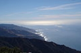
The Santa Lucia Mountains or Santa Lucia Range is a mountain range
in coastal California
, running from Monterey
southeast for 105 miles (170 km) to San Luis Obispo
. The highest summit is Junipero Serra Peak
, 1784 metres (5,853 ft) in Monterey County
. It is part of the Pacific Coast Ranges
.
an to document the Santa Lucias was Juan Rodríguez Cabrillo
in 1542 while sailing northward along the coast on a Spanish naval expedition. Cabrillo originally named the southern portion of the range the Sierras de San Martín, as he was passing the area on 11 November, the feast day for Saint Martin
. He named the northern part Sierras Nevadas because there was snow on it.
The present name for the range was documented in 1602 by Sebastián Vizcaíno
, who had been tasked by the Spanish to complete a detailed chart of the coast. Passing by the range on 14 December, he named the range Sierra de Santa Lucia in honor of Saint Lucy of Syracuse
.
, these mountains are close enough to the Pacific Ocean
and high enough to force incoming moisture upward, making the west side wet and fit for conifers to grow. This creates a rain shadow
over Salinas Valley
to the east, which is considerably drier. The higher peaks receive some snowfall during the winter.
The climate is classified as Dry Summer Subtropical, or Mediterranean
. Rainfall varies from 16 to 60 inches throughout the range, with the most on the higher mountains in the north; almost all precipitation falls in the winter. During the summer, fog and low clouds are frequent along the coast up to an elevation of several thousand feet. Surface runoff from rainfall events is rapid, and many streams dry up entirely in the summer, except for some perennial streams in the wetter areas in the north.
basement of the Salinian Block
, between the San Andreas Fault
and Sur-Nacimiento Fault. According to plate tectonic theory, the core of the Salinian block formed as part of the same batholith
which forms the core of the Sierra Nevada Mountains
and the Peninsular Ranges
of Baja California
. It was broken off the North American Plate
and transported north by the action of the San Andreas Fault
from an original position. It is predominantly Mesozoic
granitic and pre-Cretaceous
metamorphic rock
s. There is some Cretaceous sedimentary rock
of the Great Valley Sequence, considerable Miocene
marine sediments, and some other Tertiary
sediments. Units west of the Sur-Nacimiento fault are dominated by rocks of the Franciscan Assemblage
.
is moist with good forest
growth including Coast Redwood, Douglas fir, Ponderosa Pine
, Pacific Madrone
and the local endemics Santa Lucia Fir (Abies bracteata) and Gowen Cypress (Cupressus goveniana var. goveniana), while the east side is drier, with chaparral
and open woods of pine
(including Coulter Pine
and Gray Pine
) and several species of oak
. These mountains are home to the southernmost native stands of redwood trees, since the climate gets drier towards the south. This range is the only known habitat of the Vortriede's spineflower
.
, a producer of California wine
, is located in the region.
runs along the Big Sur
coast to the west of the Santa Lucias, while U.S. Route 101
lies in the Salinas Valley
to the East. The only road across the Santa Lucia Range is Nacimiento-Fergusson Road
, from Lucia
to Jolon
.
Mountain range
A mountain range is a single, large mass consisting of a succession of mountains or narrowly spaced mountain ridges, with or without peaks, closely related in position, direction, formation, and age; a component part of a mountain system or of a mountain chain...
in coastal California
California
California is a state located on the West Coast of the United States. It is by far the most populous U.S. state, and the third-largest by land area...
, running from Monterey
Monterey, California
The City of Monterey in Monterey County is located on Monterey Bay along the Pacific coast in Central California. Monterey lies at an elevation of 26 feet above sea level. As of the 2010 census, the city population was 27,810. Monterey is of historical importance because it was the capital of...
southeast for 105 miles (170 km) to San Luis Obispo
San Luis Obispo, California
San Luis Obispo is a city in California, located roughly midway between San Francisco and Los Angeles on the Central Coast. Founded in 1772 by Spanish Fr. Junipero Serra, San Luis Obispo is one of California’s oldest communities...
. The highest summit is Junipero Serra Peak
Junipero Serra Peak
Junipero Serra Peak is the highest mountain in the Santa Lucia Mountains of California. It is also the highest peak in Monterey County. It is named after Franciscan Friar Junípero Serra, founder of the California Missions.- Toponymy :...
, 1784 metres (5,853 ft) in Monterey County
Monterey County, California
Monterey County is a county located on the Pacific coast of the U.S. state of California, its northwestern section forming the southern half of Monterey Bay. The northern half of the bay is in Santa Cruz County. As of 2010, the population was 415,057. The county seat and largest city is Salinas...
. It is part of the Pacific Coast Ranges
Pacific Coast Ranges
The Pacific Coast Ranges and the Pacific Mountain System are the series of mountain ranges that stretch along the West Coast of North America from Alaska south to Northern and Central Mexico...
.
Toponymy
The first EuropeEurope
Europe is, by convention, one of the world's seven continents. Comprising the westernmost peninsula of Eurasia, Europe is generally 'divided' from Asia to its east by the watershed divides of the Ural and Caucasus Mountains, the Ural River, the Caspian and Black Seas, and the waterways connecting...
an to document the Santa Lucias was Juan Rodríguez Cabrillo
Juan Rodríguez Cabrillo
Juan Rodriguez Cabrillo was a Portuguese explorer noted for his exploration of the west coast of North America on behalf of Spain. Cabrillo was the first European explorer to navigate the coast of present day California in the United States...
in 1542 while sailing northward along the coast on a Spanish naval expedition. Cabrillo originally named the southern portion of the range the Sierras de San Martín, as he was passing the area on 11 November, the feast day for Saint Martin
Martin of Tours
Martin of Tours was a Bishop of Tours whose shrine became a famous stopping-point for pilgrims on the road to Santiago de Compostela. Around his name much legendary material accrued, and he has become one of the most familiar and recognizable Christian saints...
. He named the northern part Sierras Nevadas because there was snow on it.
The present name for the range was documented in 1602 by Sebastián Vizcaíno
Sebastián Vizcaíno
Sebastián Vizcaíno was a Spanish soldier, entrepreneur, explorer, and diplomat whose varied roles took him to New Spain, the Philippines, the Baja California peninsula, the California coast and Japan.-Early career:...
, who had been tasked by the Spanish to complete a detailed chart of the coast. Passing by the range on 14 December, he named the range Sierra de Santa Lucia in honor of Saint Lucy of Syracuse
Saint Lucy
Saint Lucy , also known as Saint Lucia, was a wealthy young Christian martyr who is venerated as a saint by Roman Catholic, Anglican, Lutheran, and Orthodox Christians. Her feast day in the West is 13 December; with a name derived from lux, lucis "light", she is the patron saint of those who are...
.
Climate
Like all other Pacific Coast RangesPacific Coast Ranges
The Pacific Coast Ranges and the Pacific Mountain System are the series of mountain ranges that stretch along the West Coast of North America from Alaska south to Northern and Central Mexico...
, these mountains are close enough to the Pacific Ocean
Pacific Ocean
The Pacific Ocean is the largest of the Earth's oceanic divisions. It extends from the Arctic in the north to the Southern Ocean in the south, bounded by Asia and Australia in the west, and the Americas in the east.At 165.2 million square kilometres in area, this largest division of the World...
and high enough to force incoming moisture upward, making the west side wet and fit for conifers to grow. This creates a rain shadow
Rain shadow
A rain shadow is a dry area on the lee side of a mountainous area. The mountains block the passage of rain-producing weather systems, casting a "shadow" of dryness behind them. As shown by the diagram to the right, the warm moist air is "pulled" by the prevailing winds over a mountain...
over Salinas Valley
Salinas Valley
The Salinas Valley lies south of San Francisco, California.The word "salina" is spanish for salt marsh, salt lake or salt pan.-Geography:The Salinas Valley runs approximately south-east from Salinas towards King City. The valley lends its name to the geologic province in which it's located, the...
to the east, which is considerably drier. The higher peaks receive some snowfall during the winter.
The climate is classified as Dry Summer Subtropical, or Mediterranean
Mediterranean climate
A Mediterranean climate is the climate typical of most of the lands in the Mediterranean Basin, and is a particular variety of subtropical climate...
. Rainfall varies from 16 to 60 inches throughout the range, with the most on the higher mountains in the north; almost all precipitation falls in the winter. During the summer, fog and low clouds are frequent along the coast up to an elevation of several thousand feet. Surface runoff from rainfall events is rapid, and many streams dry up entirely in the summer, except for some perennial streams in the wetter areas in the north.
Geology
The rock of the Santa Lucias is dominated by graniticGranite
Granite is a common and widely occurring type of intrusive, felsic, igneous rock. Granite usually has a medium- to coarse-grained texture. Occasionally some individual crystals are larger than the groundmass, in which case the texture is known as porphyritic. A granitic rock with a porphyritic...
basement of the Salinian Block
Salinian Block
The Salinian Block or Salinian terrane is a geologic terrane which lies west of the main trace of the San Andreas Fault system in California. It is bounded on the south by the Big Pine Fault in Ventura County, and on the west by the Nacimiento Fault...
, between the San Andreas Fault
San Andreas Fault
The San Andreas Fault is a continental strike-slip fault that runs a length of roughly through California in the United States. The fault's motion is right-lateral strike-slip...
and Sur-Nacimiento Fault. According to plate tectonic theory, the core of the Salinian block formed as part of the same batholith
Batholith
A batholith is a large emplacement of igneous intrusive rock that forms from cooled magma deep in the Earth's crust...
which forms the core of the Sierra Nevada Mountains
Sierra Nevada (US)
The Sierra Nevada is a mountain range in the U.S. states of California and Nevada, between the California Central Valley and the Basin and Range Province. The Sierra runs north-to-south, and is approximately across east-to-west...
and the Peninsular Ranges
Peninsular Ranges
The Peninsular Ranges are a group of mountain ranges, in the Pacific Coast Ranges, which stretch from southern California in the United States to the southern tip of Mexico's Baja California peninsula; they are part of the North American Coast Ranges that run along the Pacific coast from Alaska...
of Baja California
Baja California Peninsula
The Baja California peninsula , is a peninsula in northwestern Mexico. Its land mass separates the Pacific Ocean from the Gulf of California. The Peninsula extends from Mexicali, Baja California in the north to Cabo San Lucas, Baja California Sur in the south.The total area of the Baja California...
. It was broken off the North American Plate
North American Plate
The North American Plate is a tectonic plate covering most of North America, Greenland, Cuba, Bahamas, and parts of Siberia, Japan and Iceland. It extends eastward to the Mid-Atlantic Ridge and westward to the Chersky Range in eastern Siberia. The plate includes both continental and oceanic crust...
and transported north by the action of the San Andreas Fault
San Andreas Fault
The San Andreas Fault is a continental strike-slip fault that runs a length of roughly through California in the United States. The fault's motion is right-lateral strike-slip...
from an original position. It is predominantly Mesozoic
Mesozoic
The Mesozoic era is an interval of geological time from about 250 million years ago to about 65 million years ago. It is often referred to as the age of reptiles because reptiles, namely dinosaurs, were the dominant terrestrial and marine vertebrates of the time...
granitic and pre-Cretaceous
Cretaceous
The Cretaceous , derived from the Latin "creta" , usually abbreviated K for its German translation Kreide , is a geologic period and system from circa to million years ago. In the geologic timescale, the Cretaceous follows the Jurassic period and is followed by the Paleogene period of the...
metamorphic rock
Metamorphic rock
Metamorphic rock is the transformation of an existing rock type, the protolith, in a process called metamorphism, which means "change in form". The protolith is subjected to heat and pressure causing profound physical and/or chemical change...
s. There is some Cretaceous sedimentary rock
Sedimentary rock
Sedimentary rock are types of rock that are formed by the deposition of material at the Earth's surface and within bodies of water. Sedimentation is the collective name for processes that cause mineral and/or organic particles to settle and accumulate or minerals to precipitate from a solution....
of the Great Valley Sequence, considerable Miocene
Miocene
The Miocene is a geological epoch of the Neogene Period and extends from about . The Miocene was named by Sir Charles Lyell. Its name comes from the Greek words and and means "less recent" because it has 18% fewer modern sea invertebrates than the Pliocene. The Miocene follows the Oligocene...
marine sediments, and some other Tertiary
Tertiary
The Tertiary is a deprecated term for a geologic period 65 million to 2.6 million years ago. The Tertiary covered the time span between the superseded Secondary period and the Quaternary...
sediments. Units west of the Sur-Nacimiento fault are dominated by rocks of the Franciscan Assemblage
Franciscan Assemblage
The Franciscan Assemblage is a geological term for an accreted terrane of heterogeneous rocks found on and near the San Francisco Peninsula. It was named by geologist Andrew Lawson who also named the San Andreas Fault which bounds the Franciscan Assemblage....
.
Flora
The west slope of the range facing the Pacific OceanPacific Ocean
The Pacific Ocean is the largest of the Earth's oceanic divisions. It extends from the Arctic in the north to the Southern Ocean in the south, bounded by Asia and Australia in the west, and the Americas in the east.At 165.2 million square kilometres in area, this largest division of the World...
is moist with good forest
Forest
A forest, also referred to as a wood or the woods, is an area with a high density of trees. As with cities, depending where you are in the world, what is considered a forest may vary significantly in size and have various classification according to how and what of the forest is composed...
growth including Coast Redwood, Douglas fir, Ponderosa Pine
Ponderosa Pine
Pinus ponderosa, commonly known as the Ponderosa Pine, Bull Pine, Blackjack Pine, or Western Yellow Pine, is a widespread and variable pine native to western North America. It was first described by David Douglas in 1826, from eastern Washington near present-day Spokane...
, Pacific Madrone
Pacific Madrone
Arbutus menziesii, commonly known as the Pacific Madrone, is a species of Arbutus found on the west coast of North America, from British Columbia to California...
and the local endemics Santa Lucia Fir (Abies bracteata) and Gowen Cypress (Cupressus goveniana var. goveniana), while the east side is drier, with chaparral
Chaparral
Chaparral is a shrubland or heathland plant community found primarily in the U.S. state of California and in the northern portion of the Baja California peninsula, Mexico...
and open woods of pine
Pine
Pines are trees in the genus Pinus ,in the family Pinaceae. They make up the monotypic subfamily Pinoideae. There are about 115 species of pine, although different authorities accept between 105 and 125 species.-Etymology:...
(including Coulter Pine
Coulter Pine
The Coulter Pine or Big-cone Pine is a native of the coastal mountains of southern California and northern Baja California . Isolated groves are found as far north as the San Francisco Bay Area in Mt. Diablo State Park and Black Diamond Mines Regional Preserve...
and Gray Pine
Gray Pine
Pinus sabiniana , with the common names gray pine, California foothill pine, and the more historically and internationally used digger pine, is a pine endemic to California in the United States...
) and several species of oak
Oak
An oak is a tree or shrub in the genus Quercus , of which about 600 species exist. "Oak" may also appear in the names of species in related genera, notably Lithocarpus...
. These mountains are home to the southernmost native stands of redwood trees, since the climate gets drier towards the south. This range is the only known habitat of the Vortriede's spineflower
Systenotheca
Systenotheca is a monotypic plant genus in the buckwheat family containing the single species Systenotheca vortriedei, which is known by the common name Vortriede's spineflower.-Description:...
.
Major peaks
- Junipero Serra PeakJunipero Serra PeakJunipero Serra Peak is the highest mountain in the Santa Lucia Mountains of California. It is also the highest peak in Monterey County. It is named after Franciscan Friar Junípero Serra, founder of the California Missions.- Toponymy :...
, 1784 metres (5,853 ft) - Cone Peak, 1571 metres (5,154.2 ft). Cone Peak features the steepest coastal elevation in the lower 48 United States, rising nearly a mile (1,609 m) above sea level, only three miles (5 km) from the Pacific Ocean.
- Ventana Double ConeVentana Double ConeThe Ventana Double Cone is a prominent twin mountain top located in the northern part of the Ventana Wilderness of the Los Padres National Forest. It is a popular hiking destination.-Toponymy:...
, 1477 metres (4,845.8 ft) - Mount Carmel, 1344 metres (4,409.4 ft)
Wine
The Santa Lucia Highlands AVASanta Lucia Highlands AVA
The Santa Lucia Highlands AVA is an American Viticultural Area located in Monterey County, California. It is part of the larger Monterey AVA, and located in the Santa Lucia Mountains above the Salinas Valley. Over of vineyards are planted in the AVA, some as high as above sea level, with about...
, a producer of California wine
California wine
California wine has a long and continuing history, and in the late twentieth century became recognized as producing some of the world's finest wine. While wine is made in all fifty U.S. states, up to 90% of American wine is produced in the state...
, is located in the region.
Transportation
California State Route 1California State Route 1
State Route 1 , more often called Highway 1, is a state highway that runs along much of the Pacific coast of the U.S. state of California. It is famous for running along some of the most beautiful coastlines in the world, leading to its designation as an All-American Road.Highway 1 does not run...
runs along the Big Sur
Big Sur
Big Sur is a sparsely populated region of the Central Coast of California where the Santa Lucia Mountains rise abruptly from the Pacific Ocean. The name "Big Sur" is derived from the original Spanish-language "el sur grande", meaning "the big south", or from "el país grande del sur", "the big...
coast to the west of the Santa Lucias, while U.S. Route 101
U.S. Route 101
U.S. Route 101, or U.S. Highway 101, is an important north–south U.S. highway that runs through the states of California, Oregon, and Washington, on the West Coast of the United States...
lies in the Salinas Valley
Salinas Valley
The Salinas Valley lies south of San Francisco, California.The word "salina" is spanish for salt marsh, salt lake or salt pan.-Geography:The Salinas Valley runs approximately south-east from Salinas towards King City. The valley lends its name to the geologic province in which it's located, the...
to the East. The only road across the Santa Lucia Range is Nacimiento-Fergusson Road
Nacimiento-Fergusson Road
Nacimiento-Fergusson Road is the only road across the Santa Lucia Range in the Central Coast of California, connecting California State Route 1 and the Big Sur coast to U.S...
, from Lucia
Lucia, California
Lucia is an unincorporated community in Monterey County, California. It is located east of Lopez Point, at an elevation of 354 feet . Lucia is one of the three small settlements of restaurants, and motels located along State Route 1 on the Big Sur coast...
to Jolon
Jolon, California
Jolon is an unincorporated community in Monterey County, California. It is located south of King City, at an elevation of 971 feet . Jolon is located in the Salinas Valley in a rural area located about 6 miles from Mission San Antonio de Padua, and is part of Fort Hunter Liggett.The town was...
.
Contemporary History
Pacific Southwest Airlines Flight 1771 crashed in the mountains near Cayucos on December 7, 1987 after a gunman killed both pilots, causing the aircraft to crash. A total of 43 people were killed with no survivors.External links
- Ventana Wilderness Alliance — Dedicated to the protection, preservation, enhancement and restoration of the wilderness qualities and biodiversity of the public lands within California's northern Santa Lucia Mountains.