
Montezuma County, Colorado
Encyclopedia
Montezuma County is the southwesternmost of the 64 counties
of the state of Colorado of the United States
. The county population was 23,830 at U.S. Census 2000. The county seat
is Cortez
.
Mesa Verde National Park
, Canyons of the Ancients National Monument
, Yucca House National Monument
, and Hovenweep National Monument
preserve hundreds of ancient AmerIndian structures, including the famous cliff-dwellings, found in the county. Montezuma County is also home to most of the Ute Mountain Indian Reservation, home of the Weeminuche Band of the Ute Nation, known as the Ute Mountain Ute Tribe
, with its headquarters at Towaoc
.
Indians in Mexico, Moctezuma II
. The building ruins in Mesa Verde National Park
were thought to be of Aztec origin at the time.
Today, there are three incorporated municipalities in Montezuma County: Cortez
, Dolores
, and Mancos
, and a large number of unincorporated communities, including Towaoc, Lewis, Arriola, Mesa Verde, Lebanon, Stoner, Weber, and Battle Rock.
A large county, roughly 1/3 is tribal land, 1/3 is federal land (administered by the National Park Service
, the United States Forest Service
and the Bureau of Land Management
), and 1/3 private or state/county land. It is also varied topographically, ranging in elevation from about 6000 feet to more than 14,000 feet, and from high Colorado Plateau Desert to Alpine Tundra, and has the second largest reservoir in Colorado, McPhee Reservoir, many other large reservoirs, and hundreds of private lakes and ponds. Much of the county is irrigated cropland, and it produces fruit, large numbers of cattle and sheep, and beans. It is served by US Highways 160 and 491 (formerly the infamous US Highway 666), and by a Municipal Airport
at Cortez. It has no rail service, although both Mancos and Dolores were established as railroad towns in the 1890s.
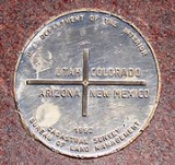
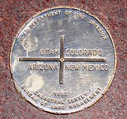
Montezuma County is the only county in the United States to border three counties with the same name in three different states (San Juan County in Colorado, New Mexico, and Utah). The "border" with San Juan County, Colorado, is, however, only a point
of zero length.
of 2000, there were 23,830 people, 9,201 households, and 6,514 families residing in the county. The population density
was 12 people per square mile (5/km²). There were 10,497 housing units at an average density of 5 per square mile (2/km²). The racial makeup of the county was 81.72% White
, 0.14% Black
or African American
, 11.23% Native American
, 0.20% Asian
, 0.06% Pacific Islander
, 4.26% from other races
, and 2.38% from two or more races. 9.50% of the population were Hispanic
or Latino
of any race.
There were 9,201 households out of which 33.30% had children under the age of 18 living with them, 56.40% were married couples
living together, 10.60% had a female householder with no husband present, and 29.20% were non-families. 24.60% of all households were made up of individuals and 9.30% had someone living alone who was 65 years of age or older. The average household size was 2.54 and the average family size was 3.04.
In the county the population was spread out with 27.50% under the age of 18, 7.10% from 18 to 24, 26.30% from 25 to 44, 25.30% from 45 to 64, and 13.80% who were 65 years of age or older. The median age was 38 years. For every 100 females there were 96.70 males. For every 100 females age 18 and over, there were 92.20 males.
The median income for a household in the county was $32,083, and the median income for a family was $38,071. Males had a median income of $30,666 versus $21,181 for females. The per capita income
for the county was $17,003. About 13.10% of families and 16.40% of the population were below the poverty line, including 23.20% of those under age 18 and 14.40% of those age 65 or over.
Colorado counties
The U.S state of Colorado is divided into 64 counties. Counties are important units of government in Colorado since the state has no secondary civil subdivisions, such as townships...
of the state of Colorado of the United States
United States
The United States of America is a federal constitutional republic comprising fifty states and a federal district...
. The county population was 23,830 at U.S. Census 2000. The county seat
County seat
A county seat is an administrative center, or seat of government, for a county or civil parish. The term is primarily used in the United States....
is Cortez
Cortez, Colorado
The city of Cortez is a Home Rule Municipality that is the county seat and the most populous city of Montezuma County, Colorado, United States. The city population was 8,482 at the 2010 census...
.
Mesa Verde National Park
Mesa Verde National Park
Mesa Verde National Park is a U.S. National Park and UNESCO World Heritage Site located in Montezuma County, Colorado, United States. It was created in 1906 to protect some of the best-preserved cliff dwellings in the world...
, Canyons of the Ancients National Monument
Canyons of the Ancients National Monument
Canyons of the Ancients National Monument is located in the southwestern region of the U.S. state of Colorado, and is managed by the U.S. Bureau of Land Management, an agency within the U.S. Department of the Interior...
, Yucca House National Monument
Yucca House National Monument
Yucca House National Monument is a United States National Monument located in Montezuma County, Colorado between the towns of Towaoc and Cortez, Colorado...
, and Hovenweep National Monument
Hovenweep National Monument
Hovenweep National Monument is located on land in southwestern Colorado and southeastern Utah, located between Cortez, Colorado and Blanding, Utah on the Cajon Mesa of the Great Sage Plain...
preserve hundreds of ancient AmerIndian structures, including the famous cliff-dwellings, found in the county. Montezuma County is also home to most of the Ute Mountain Indian Reservation, home of the Weeminuche Band of the Ute Nation, known as the Ute Mountain Ute Tribe
Ute Mountain Ute Tribe
The Ute Mountain Ute Tribe is one of three federally recognized tribes of the Ute Nation, and are mostly descendants of the historic Weeminuche Band who moved to the Southern Ute reservation in 1897...
, with its headquarters at Towaoc
Towaoc, Colorado
Towaoc is a census-designated place on the Ute Mountain Ute Tribe Reservation in Montezuma County, Colorado, United States. The population was 1,097 at the 2000 census. The Towaoc Post Office has the ZIP Code 81334....
.
History
Montezuma County has been settled since approximately AD 600, and had an estimated population of approximately 100,000, four times its current population, in the 12th century. However, a series of events caused virtually all permanent settlements to be abandoned between 1200 and 1300, and the area was contested between nomadic Ute and Navajo bands until resettlement occurred in the 1870s. Montezuma County was created out of the western portion of La Plata County by the Colorado Legislature in April, 1889. It was named in honor of a famous chief of the AztecAztec
The Aztec people were certain ethnic groups of central Mexico, particularly those groups who spoke the Nahuatl language and who dominated large parts of Mesoamerica in the 14th, 15th and 16th centuries, a period referred to as the late post-classic period in Mesoamerican chronology.Aztec is the...
Indians in Mexico, Moctezuma II
Moctezuma II
Moctezuma , also known by a number of variant spellings including Montezuma, Moteuczoma, Motecuhzoma and referred to in full by early Nahuatl texts as Motecuhzoma Xocoyotzin, was the ninth tlatoani or ruler of Tenochtitlan, reigning from 1502 to 1520...
. The building ruins in Mesa Verde National Park
Mesa Verde National Park
Mesa Verde National Park is a U.S. National Park and UNESCO World Heritage Site located in Montezuma County, Colorado, United States. It was created in 1906 to protect some of the best-preserved cliff dwellings in the world...
were thought to be of Aztec origin at the time.
Geography
According to the 2000 census, the county has a total area of 2039.97 square miles (5,283.5 km²), of which 2036.63 square miles (5,274.8 km²) (or 99.84%) is land and 3.34 square miles (8.7 km²) (or 0.16%) is water.Today, there are three incorporated municipalities in Montezuma County: Cortez
Cortez, Colorado
The city of Cortez is a Home Rule Municipality that is the county seat and the most populous city of Montezuma County, Colorado, United States. The city population was 8,482 at the 2010 census...
, Dolores
Dolores, Colorado
The town of Dolores is a Statutory Town in Montezuma County, Colorado, United States. The population was 936 at the 2010 census. It is one of three incorporated municipalities in the county....
, and Mancos
Mancos, Colorado
The town of Mancos is a Statutory Town located in Montezuma County, Colorado, United States. The population was 1,119 at the 2000 census.The town of Mancos is located in southwestern Colorado, near the Four Corners, at the base of Mesa Verde National Park, and holds the trademark for "Gateway to...
, and a large number of unincorporated communities, including Towaoc, Lewis, Arriola, Mesa Verde, Lebanon, Stoner, Weber, and Battle Rock.
A large county, roughly 1/3 is tribal land, 1/3 is federal land (administered by the National Park Service
National Park Service
The National Park Service is the U.S. federal agency that manages all national parks, many national monuments, and other conservation and historical properties with various title designations...
, the United States Forest Service
United States Forest Service
The United States Forest Service is an agency of the United States Department of Agriculture that administers the nation's 155 national forests and 20 national grasslands, which encompass...
and the Bureau of Land Management
Bureau of Land Management
The Bureau of Land Management is an agency within the United States Department of the Interior which administers America's public lands, totaling approximately , or one-eighth of the landmass of the country. The BLM also manages of subsurface mineral estate underlying federal, state and private...
), and 1/3 private or state/county land. It is also varied topographically, ranging in elevation from about 6000 feet to more than 14,000 feet, and from high Colorado Plateau Desert to Alpine Tundra, and has the second largest reservoir in Colorado, McPhee Reservoir, many other large reservoirs, and hundreds of private lakes and ponds. Much of the county is irrigated cropland, and it produces fruit, large numbers of cattle and sheep, and beans. It is served by US Highways 160 and 491 (formerly the infamous US Highway 666), and by a Municipal Airport
Cortez Municipal Airport
Cortez Municipal Airport is a public airport located three miles southwest of the central business district of Cortez, a city in Montezuma County, Colorado, USA. The airport covers and has one runway. It is mostly used for general aviation, but is also served by one commercial airline...
at Cortez. It has no rail service, although both Mancos and Dolores were established as railroad towns in the 1890s.
Adjacent counties
- Dolores CountyDolores County, ColoradoDolores County is the seventh least populous of the 64 counties of the State of Colorado of the United States. The county population was 1,844 at U.S. Census 2000. The county seat is Dove Creek.- History :...
, ColoradoColoradoColorado is a U.S. state that encompasses much of the Rocky Mountains as well as the northeastern portion of the Colorado Plateau and the western edge of the Great Plains...
- north - San Juan CountySan Juan County, ColoradoSan Juan County is the least populous of the 64 counties of the state of Colorado in the United States. The county name is the Spanish language name for “Saint John”, the name Spanish explorers gave to a river and the mountain range in the area. The county population was 558 at U.S. Census 2000...
, ColoradoColoradoColorado is a U.S. state that encompasses much of the Rocky Mountains as well as the northeastern portion of the Colorado Plateau and the western edge of the Great Plains...
- northeast - La Plata CountyLa Plata County, ColoradoLa Plata County is the fourteenth most populous of the 64 counties of the State of Colorado of the United States. The county was named for the La Plata River and the La Plata Mountains. "La plata" is the Spanish language word for "silver". The United States Census Bureau estimated that the...
, ColoradoColoradoColorado is a U.S. state that encompasses much of the Rocky Mountains as well as the northeastern portion of the Colorado Plateau and the western edge of the Great Plains...
- east - San Juan CountySan Juan County, New Mexico-2010:Whereas according to the 2010 U.S. Census Bureau:*51.6% White*0.6% Black*36.6% Native American*0.4% Asian*0.1% Native Hawaiian or Pacific Islander*3.5% Two or more races*7.2% Other races*19.1% Hispanic or Latino -2000:...
, New MexicoNew MexicoNew Mexico is a state located in the southwest and western regions of the United States. New Mexico is also usually considered one of the Mountain States. With a population density of 16 per square mile, New Mexico is the sixth-most sparsely inhabited U.S...
- south - Apache CountyApache County, Arizona-2010:Whereas according to the 2010 U.S. Census Bureau:*23.3% White*0.2% Black*72.9% Native American*0.3% Asian*0.0% Native Hawaiian or Pacific Islander*2.0% Two or more races*1.3% Other races*5.8% Hispanic or Latino -2000:...
, ArizonaArizonaArizona ; is a state located in the southwestern region of the United States. It is also part of the western United States and the mountain west. The capital and largest city is Phoenix...
- southwest - San Juan CountySan Juan County, UtahAs of the current census of 2010, there were 14,746 people and 4,505 households. The racial and ethnic composition of the population was 50.4% Native American, 45.8% white, 0.3% Asian, 0.2% African American and 2.3% reporting two or more races...
, UtahUtahUtah is a state in the Western United States. It was the 45th state to join the Union, on January 4, 1896. Approximately 80% of Utah's 2,763,885 people live along the Wasatch Front, centering on Salt Lake City. This leaves vast expanses of the state nearly uninhabited, making the population the...
- west
Montezuma County is the only county in the United States to border three counties with the same name in three different states (San Juan County in Colorado, New Mexico, and Utah). The "border" with San Juan County, Colorado, is, however, only a point
Point (geometry)
In geometry, topology and related branches of mathematics a spatial point is a primitive notion upon which other concepts may be defined. In geometry, points are zero-dimensional; i.e., they do not have volume, area, length, or any other higher-dimensional analogue. In branches of mathematics...
of zero length.
Demographics
As of the censusCensus
A census is the procedure of systematically acquiring and recording information about the members of a given population. It is a regularly occurring and official count of a particular population. The term is used mostly in connection with national population and housing censuses; other common...
of 2000, there were 23,830 people, 9,201 households, and 6,514 families residing in the county. The population density
Population density
Population density is a measurement of population per unit area or unit volume. It is frequently applied to living organisms, and particularly to humans...
was 12 people per square mile (5/km²). There were 10,497 housing units at an average density of 5 per square mile (2/km²). The racial makeup of the county was 81.72% White
Race (United States Census)
Race and ethnicity in the United States Census, as defined by the Federal Office of Management and Budget and the United States Census Bureau, are self-identification data items in which residents choose the race or races with which they most closely identify, and indicate whether or not they are...
, 0.14% Black
Race (United States Census)
Race and ethnicity in the United States Census, as defined by the Federal Office of Management and Budget and the United States Census Bureau, are self-identification data items in which residents choose the race or races with which they most closely identify, and indicate whether or not they are...
or African American
Race (United States Census)
Race and ethnicity in the United States Census, as defined by the Federal Office of Management and Budget and the United States Census Bureau, are self-identification data items in which residents choose the race or races with which they most closely identify, and indicate whether or not they are...
, 11.23% Native American
Race (United States Census)
Race and ethnicity in the United States Census, as defined by the Federal Office of Management and Budget and the United States Census Bureau, are self-identification data items in which residents choose the race or races with which they most closely identify, and indicate whether or not they are...
, 0.20% Asian
Race (United States Census)
Race and ethnicity in the United States Census, as defined by the Federal Office of Management and Budget and the United States Census Bureau, are self-identification data items in which residents choose the race or races with which they most closely identify, and indicate whether or not they are...
, 0.06% Pacific Islander
Race (United States Census)
Race and ethnicity in the United States Census, as defined by the Federal Office of Management and Budget and the United States Census Bureau, are self-identification data items in which residents choose the race or races with which they most closely identify, and indicate whether or not they are...
, 4.26% from other races
Race (United States Census)
Race and ethnicity in the United States Census, as defined by the Federal Office of Management and Budget and the United States Census Bureau, are self-identification data items in which residents choose the race or races with which they most closely identify, and indicate whether or not they are...
, and 2.38% from two or more races. 9.50% of the population were Hispanic
Race (United States Census)
Race and ethnicity in the United States Census, as defined by the Federal Office of Management and Budget and the United States Census Bureau, are self-identification data items in which residents choose the race or races with which they most closely identify, and indicate whether or not they are...
or Latino
Race (United States Census)
Race and ethnicity in the United States Census, as defined by the Federal Office of Management and Budget and the United States Census Bureau, are self-identification data items in which residents choose the race or races with which they most closely identify, and indicate whether or not they are...
of any race.
There were 9,201 households out of which 33.30% had children under the age of 18 living with them, 56.40% were married couples
Marriage
Marriage is a social union or legal contract between people that creates kinship. It is an institution in which interpersonal relationships, usually intimate and sexual, are acknowledged in a variety of ways, depending on the culture or subculture in which it is found...
living together, 10.60% had a female householder with no husband present, and 29.20% were non-families. 24.60% of all households were made up of individuals and 9.30% had someone living alone who was 65 years of age or older. The average household size was 2.54 and the average family size was 3.04.
In the county the population was spread out with 27.50% under the age of 18, 7.10% from 18 to 24, 26.30% from 25 to 44, 25.30% from 45 to 64, and 13.80% who were 65 years of age or older. The median age was 38 years. For every 100 females there were 96.70 males. For every 100 females age 18 and over, there were 92.20 males.
The median income for a household in the county was $32,083, and the median income for a family was $38,071. Males had a median income of $30,666 versus $21,181 for females. The per capita income
Per capita income
Per capita income or income per person is a measure of mean income within an economic aggregate, such as a country or city. It is calculated by taking a measure of all sources of income in the aggregate and dividing it by the total population...
for the county was $17,003. About 13.10% of families and 16.40% of the population were below the poverty line, including 23.20% of those under age 18 and 14.40% of those age 65 or over.
Cities and towns
- CortezCortez, ColoradoThe city of Cortez is a Home Rule Municipality that is the county seat and the most populous city of Montezuma County, Colorado, United States. The city population was 8,482 at the 2010 census...
- DoloresDolores, ColoradoThe town of Dolores is a Statutory Town in Montezuma County, Colorado, United States. The population was 936 at the 2010 census. It is one of three incorporated municipalities in the county....
- MancosMancos, ColoradoThe town of Mancos is a Statutory Town located in Montezuma County, Colorado, United States. The population was 1,119 at the 2000 census.The town of Mancos is located in southwestern Colorado, near the Four Corners, at the base of Mesa Verde National Park, and holds the trademark for "Gateway to...
- TowaocTowaoc, ColoradoTowaoc is a census-designated place on the Ute Mountain Ute Tribe Reservation in Montezuma County, Colorado, United States. The population was 1,097 at the 2000 census. The Towaoc Post Office has the ZIP Code 81334....
National parks
- Canyons of the Ancients National MonumentCanyons of the Ancients National MonumentCanyons of the Ancients National Monument is located in the southwestern region of the U.S. state of Colorado, and is managed by the U.S. Bureau of Land Management, an agency within the U.S. Department of the Interior...
(part) - administered by Bureau of Land Management - Hovenweep National MonumentHovenweep National MonumentHovenweep National Monument is located on land in southwestern Colorado and southeastern Utah, located between Cortez, Colorado and Blanding, Utah on the Cajon Mesa of the Great Sage Plain...
(part) - Mesa Verde National ParkMesa Verde National ParkMesa Verde National Park is a U.S. National Park and UNESCO World Heritage Site located in Montezuma County, Colorado, United States. It was created in 1906 to protect some of the best-preserved cliff dwellings in the world...
and UNESCOUNESCOThe United Nations Educational, Scientific and Cultural Organization is a specialized agency of the United Nations...
World Heritage SiteWorld Heritage SiteA UNESCO World Heritage Site is a place that is listed by the UNESCO as of special cultural or physical significance... - Yucca House National MonumentYucca House National MonumentYucca House National Monument is a United States National Monument located in Montezuma County, Colorado between the towns of Towaoc and Cortez, Colorado...
Other protected areas
- Lowry Ruin National Historic Landmark now part of Canyons of the Ancients National MonumentCanyons of the Ancients National MonumentCanyons of the Ancients National Monument is located in the southwestern region of the U.S. state of Colorado, and is managed by the U.S. Bureau of Land Management, an agency within the U.S. Department of the Interior...
- Mancos State ParkMancos State ParkMancos State Park is a Colorado state park. It is located near Mesa Verde National Park, the West Mancos Trailhead and the San Juan Skyway. The park is known to have been a dwelling place for Ancestral Puebloans. They lived in the Four Corners area in ancient times from AD 1 to 1300. It was also...
- Mesa Verde WildernessMesa Verde WildernessMesa Verde Wilderness is a wilderness area located within Mesa Verde National Park in the U.S. state of Colorado.These three small and separate sections of the National Park are located on the steep north and east boundaries and serve as buffers to further protect the significant Native American...
- San Juan National ForestSan Juan National ForestThe San Juan National Forest is a U.S. National Forest covering over 1,878,846 acres in Archuleta, Conjeos, Dolores, Hinsdale, La Plata, Mineral, Montezuma, Rio Grande, San Miguel and San Juan Counties in western Colorado. It borders the Uncompahgre National Forest to the north and the Rio Grande...
- McPhee ReservoirMcPhee ReservoirMcPhee Reservoir is located in Montezuma County, Colorado, United States. It is the second largest artificial body of water in Colorado. It was constructed and is operated by the United States Bureau of Reclamation as part of the Dolores Project, and dams the Dolores River to furnish irrigation...
National trails
- Calico National Recreation TrailCalico National Recreation TrailCalico National Recreation Trail, also known as the Upper Calico Trail, is located in the Dolores Ranger District of San Juan National Forest, the 5.5 mile Upper Calico Trail is rated moderate/difficult and has a starting elevation of 10,150' and an ending elevation of 10,400' .Part of the...
- Highline Loop National Recreation Trail
- Old Spanish National Historic Trail
- Petroglyph Point National Recreation Trail
National scenic byways
- San Juan Skyway National Scenic Byway
- Trail of the Ancients National Scenic and Historic BywayTrail of the AncientsThe Trail of the Ancients is an National Scenic Byway located in the states of Colorado and Utah. The route highlights the archaeological and cultural history of southwestern Native American peoples, and traverses the widely diverse geological landscape of the Four Corners region...
See also
- Colorado census statistical areas
- Colorado countiesColorado countiesThe U.S state of Colorado is divided into 64 counties. Counties are important units of government in Colorado since the state has no secondary civil subdivisions, such as townships...
- Colorado municipalitiesColorado municipalitiesThe U.S. state of Colorado currently has 271 active incorporated municipalities, including 196 towns, 73 cities, and two consolidated city and county governments.-Municipal government:...
- William B. EbbertWilliam B. EbbertWilliam Baltzell Ebbert was an officer and adjutant in the Union Army , a Colorado legislator, newspaper publisher, author, farmer, businessman, and poet...
, represented Montezuma in the Colorado General Assembly in early 20th century. - National Register of Historic Places listings in Montezuma County, ColoradoNational Register of Historic Places listings in Montezuma County, ColoradoThis is a list of the National Register of Historic Places listings in Montezuma County, Colorado. It is intended to be a complete list of the properties and districts on the National Register of Historic Places in Montezuma County, Colorado, United States...