

Ottawa County, Kansas
Encyclopedia
Ottawa County is a county located in the U.S. state
of Kansas
. As of the 2010 census, the county population was 6,091. The largest city and county seat
is Minneapolis
. Ottawa County is part of the Salina
Micropolitan Statistical Area
.
The county should not be confused with the city of Ottawa
, which is located in Franklin County
.
, county until 2006, when voters approved the sale of alcoholic liquor by the individual drink with a 30% food sales requirement.
is the longest river in the county, entering from Cloud County
to the northwest and exiting to Saline County
to the southeast. The Saline River
traverses the southwestern portion of the county, going from Lincoln County
to Saline County
.
The largest lake is Ottawa State Fishing Lake, a 111 acre (0.44920146 km²) reservoir
to the east of Minneapolis. It is managed by the Kansas Department of Wildlife and Parks
.
 As of the census
of 2000, there were 6,163 people, 2,430 households, and 1,718 families residing in the county. The population density
was 8 people per square mile (3/km²). There were 2,755 housing units at an average density of 4 per square mile (1/km²). The racial makeup of the county was 97.53% White
, 0.54% Black
or African American
, 0.37% Native American
, 0.13% Asian
, 0.02% Pacific Islander
, 0.32% from other races
, and 1.09% from two or more races. 1.30% of the population were Hispanic
or Latino
of any race.
There were 2,430 households out of which 31.60% had children under the age of 18 living with them, 61.40% were married couples
living together, 6.30% had a female householder with no husband present, and 29.30% were non-families. 25.70% of all households were made up of individuals and 13.40% had someone living alone who was 65 years of age or older. The average household size was 2.46 and the average family size was 2.96.
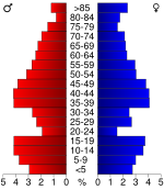
In the county the population was spread out with 25.70% under the age of 18, 5.80% from 18 to 24, 26.70% from 25 to 44, 24.20% from 45 to 64, and 17.60% who were 65 years of age or older. The median age was 40 years. For every 100 females there were 99.90 males. For every 100 females age 18 and over, there were 95.90 males.
The median income for a household in the county was $38,009, and the median income for a family was $46,033. Males had a median income of $30,761 versus $21,380 for females. The per capita income
for the county was $17,663. About 5.10% of families and 8.60% of the population were below the poverty line, including 8.80% of those under age 18 and 11.70% of those age 65 or over.
. The city of Minneapolis
is considered governmentally independent and is excluded from the census figures for the townships. In the following table, the population center is the largest city (or cities) included in that township's population total, if it is of a significant size.
Maps
U.S. state
A U.S. state is any one of the 50 federated states of the United States of America that share sovereignty with the federal government. Because of this shared sovereignty, an American is a citizen both of the federal entity and of his or her state of domicile. Four states use the official title of...
of Kansas
Kansas
Kansas is a US state located in the Midwestern United States. It is named after the Kansas River which flows through it, which in turn was named after the Kansa Native American tribe, which inhabited the area. The tribe's name is often said to mean "people of the wind" or "people of the south...
. As of the 2010 census, the county population was 6,091. The largest city and county seat
County seat
A county seat is an administrative center, or seat of government, for a county or civil parish. The term is primarily used in the United States....
is Minneapolis
Minneapolis, Kansas
Minneapolis is a city in and the county seat of Ottawa County, Kansas, United States. As of the 2010 census, the city population was 2,032. Minneapolis is part of the Salina Micropolitan Statistical Area.-Geography:...
. Ottawa County is part of the Salina
Salina, Kansas
Salina is a city in and the county seat of Saline County, Kansas, United States. As of the 2010 census, the city population was 47,707. Located in one of the world's largest wheat-producing areas, Salina is a regional trade center for north-central Kansas...
Micropolitan Statistical Area
Salina micropolitan area
The Salina Micropolitan Statistical Area, as defined by the United States Census Bureau, is an area consisting of two counties in Kansas, anchored by the city of Salina....
.
The county should not be confused with the city of Ottawa
Ottawa, Kansas
Ottawa is a city situated along the Marais des Cygnes River in the central part of Franklin County, located in east-central Kansas, 50 miles southwest of Kansas City, Mo., in the central United States. As of the 2010 census, the city population was 12,649. It is the county seat and most populous...
, which is located in Franklin County
Franklin County, Kansas
Franklin County is a county located in East Central Kansas, in the Central United States. As of the 2010 census, the county population was 25,992. Its county seat and most populous city is Ottawa...
.
Law and government
Following amendment to the Kansas Constitution in 1986, Ottawa County remained a prohibition, or "dry"Dry county
A dry county is a county in the United States whose government forbids the sale of alcoholic beverages. Some prohibit off-premises sale, some prohibit on-premises sale, and some prohibit both. Hundreds of dry counties exist across the United States, almost all of them in the South...
, county until 2006, when voters approved the sale of alcoholic liquor by the individual drink with a 30% food sales requirement.
Geography
According to the 2000 census, the county has a total area of 721.9 square miles (1,869.7 km²), of which 721.11 square miles (1,867.7 km²) (or 99.89%) is land and 0.79 square miles (2 km²) (or 0.11%) is water.Geographic features
The Solomon RiverSolomon River
The Solomon River, often referred to as the "Solomon Fork", is a river in the central Great Plains of North America. The entire length of the river lies in the U.S. state of Kansas. It is a tributary of the Smoky Hill River.-Names:...
is the longest river in the county, entering from Cloud County
Cloud County, Kansas
Cloud County is a county located in North Central Kansas, in the Central United States. As of the 2010 census, the county population was 9,533. Its county seat and most populous city is Concordia.-19th century:...
to the northwest and exiting to Saline County
Saline County, Kansas
Saline County is a county located in the U.S. state of Kansas. As of the 2010 census, the county population was 55,606...
to the southeast. The Saline River
Saline River (Kansas)
The Saline River is a tributary of the Smoky Hill River in the central Great Plains of North America. The entire length of the river lies in the U.S. state of Kansas. The river takes its name from the French translation of its Native name Ne Miskua, referring to its salty content.-Geography:The...
traverses the southwestern portion of the county, going from Lincoln County
Lincoln County, Kansas
Lincoln County is a county located in the U.S. state of Kansas. As of the 2010 census, the county population was 3,241...
to Saline County
Saline County, Kansas
Saline County is a county located in the U.S. state of Kansas. As of the 2010 census, the county population was 55,606...
.
The largest lake is Ottawa State Fishing Lake, a 111 acre (0.44920146 km²) reservoir
Reservoir
A reservoir , artificial lake or dam is used to store water.Reservoirs may be created in river valleys by the construction of a dam or may be built by excavation in the ground or by conventional construction techniques such as brickwork or cast concrete.The term reservoir may also be used to...
to the east of Minneapolis. It is managed by the Kansas Department of Wildlife and Parks
Kansas Department of Wildlife and Parks
The Kansas Department of Wildlife and Parks is a state cabinet-level agency led by a Secretary of Wildlife and Parks appointed by the Governor of Kansas. The Office of the Secretary is located in Topeka, the state capital of Kansas...
.
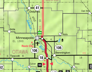
Adjacent counties
- Cloud CountyCloud County, KansasCloud County is a county located in North Central Kansas, in the Central United States. As of the 2010 census, the county population was 9,533. Its county seat and most populous city is Concordia.-19th century:...
(north) - Clay CountyClay County, KansasClay County is a county located in North Central Kansas, in the Central United States. As of the 2010 census, the county population was 8,535...
(northeast) - Dickinson CountyDickinson County, KansasDickinson County is a county located in Central Kansas, in the Central United States. As of the 2010 census, the county population was 19,754. Its county seat and most populous city is Abilene. It was named in honor of Daniel S. Dickinson.-19th century:In 1887, Mr. Herington successfully got...
(southeast) - Saline CountySaline County, KansasSaline County is a county located in the U.S. state of Kansas. As of the 2010 census, the county population was 55,606...
(south) - Lincoln CountyLincoln County, KansasLincoln County is a county located in the U.S. state of Kansas. As of the 2010 census, the county population was 3,241...
(west) - Mitchell CountyMitchell County, KansasMitchell County is a county located in the U.S. state of Kansas. As of the 2010 census, the county population was 6,373...
(northwest)
Demographics
Census
A census is the procedure of systematically acquiring and recording information about the members of a given population. It is a regularly occurring and official count of a particular population. The term is used mostly in connection with national population and housing censuses; other common...
of 2000, there were 6,163 people, 2,430 households, and 1,718 families residing in the county. The population density
Population density
Population density is a measurement of population per unit area or unit volume. It is frequently applied to living organisms, and particularly to humans...
was 8 people per square mile (3/km²). There were 2,755 housing units at an average density of 4 per square mile (1/km²). The racial makeup of the county was 97.53% White
Race (United States Census)
Race and ethnicity in the United States Census, as defined by the Federal Office of Management and Budget and the United States Census Bureau, are self-identification data items in which residents choose the race or races with which they most closely identify, and indicate whether or not they are...
, 0.54% Black
Race (United States Census)
Race and ethnicity in the United States Census, as defined by the Federal Office of Management and Budget and the United States Census Bureau, are self-identification data items in which residents choose the race or races with which they most closely identify, and indicate whether or not they are...
or African American
Race (United States Census)
Race and ethnicity in the United States Census, as defined by the Federal Office of Management and Budget and the United States Census Bureau, are self-identification data items in which residents choose the race or races with which they most closely identify, and indicate whether or not they are...
, 0.37% Native American
Race (United States Census)
Race and ethnicity in the United States Census, as defined by the Federal Office of Management and Budget and the United States Census Bureau, are self-identification data items in which residents choose the race or races with which they most closely identify, and indicate whether or not they are...
, 0.13% Asian
Race (United States Census)
Race and ethnicity in the United States Census, as defined by the Federal Office of Management and Budget and the United States Census Bureau, are self-identification data items in which residents choose the race or races with which they most closely identify, and indicate whether or not they are...
, 0.02% Pacific Islander
Race (United States Census)
Race and ethnicity in the United States Census, as defined by the Federal Office of Management and Budget and the United States Census Bureau, are self-identification data items in which residents choose the race or races with which they most closely identify, and indicate whether or not they are...
, 0.32% from other races
Race (United States Census)
Race and ethnicity in the United States Census, as defined by the Federal Office of Management and Budget and the United States Census Bureau, are self-identification data items in which residents choose the race or races with which they most closely identify, and indicate whether or not they are...
, and 1.09% from two or more races. 1.30% of the population were Hispanic
Race (United States Census)
Race and ethnicity in the United States Census, as defined by the Federal Office of Management and Budget and the United States Census Bureau, are self-identification data items in which residents choose the race or races with which they most closely identify, and indicate whether or not they are...
or Latino
Race (United States Census)
Race and ethnicity in the United States Census, as defined by the Federal Office of Management and Budget and the United States Census Bureau, are self-identification data items in which residents choose the race or races with which they most closely identify, and indicate whether or not they are...
of any race.
There were 2,430 households out of which 31.60% had children under the age of 18 living with them, 61.40% were married couples
Marriage
Marriage is a social union or legal contract between people that creates kinship. It is an institution in which interpersonal relationships, usually intimate and sexual, are acknowledged in a variety of ways, depending on the culture or subculture in which it is found...
living together, 6.30% had a female householder with no husband present, and 29.30% were non-families. 25.70% of all households were made up of individuals and 13.40% had someone living alone who was 65 years of age or older. The average household size was 2.46 and the average family size was 2.96.
In the county the population was spread out with 25.70% under the age of 18, 5.80% from 18 to 24, 26.70% from 25 to 44, 24.20% from 45 to 64, and 17.60% who were 65 years of age or older. The median age was 40 years. For every 100 females there were 99.90 males. For every 100 females age 18 and over, there were 95.90 males.
The median income for a household in the county was $38,009, and the median income for a family was $46,033. Males had a median income of $30,761 versus $21,380 for females. The per capita income
Per capita income
Per capita income or income per person is a measure of mean income within an economic aggregate, such as a country or city. It is calculated by taking a measure of all sources of income in the aggregate and dividing it by the total population...
for the county was $17,663. About 5.10% of families and 8.60% of the population were below the poverty line, including 8.80% of those under age 18 and 11.70% of those age 65 or over.
Incorporated cities
Name and population (2004 estimate):- MinneapolisMinneapolis, KansasMinneapolis is a city in and the county seat of Ottawa County, Kansas, United States. As of the 2010 census, the city population was 2,032. Minneapolis is part of the Salina Micropolitan Statistical Area.-Geography:...
, 2,037 (county seat) - BenningtonBennington, KansasBennington is a city in Ottawa County, Kansas, United States. As of the 2010 census, the city population was 672. It is part of the Salina Micropolitan Statistical Area.-History:...
, 618 - DelphosDelphos, KansasDelphos is a city in Ottawa County, Kansas, United States. As of the 2010 census, the city population was 359. It is part of the Salina Micropolitan Statistical Area. The community was named after Delphos, Ohio.-Geography:...
, 456 - TescottTescott, KansasTescott is a city in Ottawa County, Kansas, United States. As of the 2010 census, the city population was 319. It is part of the Salina Micropolitan Statistical Area.-Geography:Tescott is located at...
, 336 - CulverCulver, KansasCulver is a city in Ottawa County, Kansas, United States. As of the 2010 census, the city population was 121. It is part of the Salina Micropolitan Statistical Area.-Geography:Culver is located at...
, 167
Townships
Ottawa County is divided into twenty townshipsCivil township
A civil township is a widely used unit of local government in the United States, subordinate to, and geographic divisions of, a county. Specific responsibilities and the degree of autonomy vary based on each state. Civil townships are distinct from survey townships, but in states that have both,...
. The city of Minneapolis
Minneapolis, Kansas
Minneapolis is a city in and the county seat of Ottawa County, Kansas, United States. As of the 2010 census, the city population was 2,032. Minneapolis is part of the Salina Micropolitan Statistical Area.-Geography:...
is considered governmentally independent and is excluded from the census figures for the townships. In the following table, the population center is the largest city (or cities) included in that township's population total, if it is of a significant size.
| Township | FIPS | Population center |
Population | Population density /km² (/sq mi) |
Land area km² (sq mi) | Water area km² (sq mi) | Water % | Geographic coordinates |
|---|---|---|---|---|---|---|---|---|
| Bennington | 06100 | 1,116 | 10 (27) | 109 (42) | 0 (0) | 0.11% | 39°0′31"N 97°36′20"W | |
| Blaine | 07150 | 111 | 1 (3) | 94 (36) | 0 (0) | 0.07% | 39°10′7"N 97°39′50"W | |
| Buckeye | 08975 | 101 | 1 (3) | 78 (30) | 0 (0) | 0.13% | 39°0′4"N 97°31′20"W | |
| Center | 11975 | 72 | 1 (2) | 92 (36) | 0 (0) | 0.17% | 39°6′53"N 97°44′39"W | |
| Chapman | 12575 | 67 | 1 (2) | 93 (36) | 0 (0) | 0 % | 39°16′47"N 97°24′53"W | |
| Concord | 15175 | 209 | 2 (6) | 90 (35) | 0 (0) | 0.08% | 39°5′9"N 97°39′37"W | |
| Culver | 16725 | 318 | 3 (9) | 94 (36) | 0 (0) | 0.08% | 38°59′40"N 97°46′14"W | |
| Durham | 19075 | 25 | 0 (1) | 93 (36) | 0 (0) | 0.02% | 39°9′57"N 97°24′54"W | |
| Fountain | 24075 | 190 | 2 (5) | 94 (36) | 0 (0) | 0.02% | 39°10′6"N 97°53′1"W | |
| Garfield | 25725 | 95 | 1 (3) | 94 (36) | 0 (0) | 0.11% | 39°10′37"N 97°45′5"W | |
| Grant | 27900 | 93 | 1 (3) | 94 (36) | 0 (0) | 0.03% | 39°9′53"N 97°33′14"W | |
| Henry | 31325 | 22 | 0 (1) | 93 (36) | 0 (0) | 0.14% | 39°6′18"N 97°53′6"W | |
| Lincoln | 40950 | 143 | 2 (4) | 93 (36) | 0 (0) | 0.10% | 38°59′31"N 97°26′13"W | |
| Logan | 42050 | 82 | 1 (2) | 93 (36) | 0 (0) | 0.10% | 39°15′4"N 97°38′29"W | |
| Morton | 48500 | 498 | 5 (14) | 93 (36) | 0 (0) | 0.14% | 39°0′32"N 97°52′23"W | |
| Ottawa | 53600 | 49 | 1 (1) | 93 (36) | 0 (0) | 0.03% | 39°4′1"N 97°26′11"W | |
| Richland | 59500 | 218 | 2 (6) | 92 (36) | 0 (0) | 0.51% | 39°5′45"N 97°32′53"W | |
| Sheridan | 64725 | 589 | 6 (16) | 94 (36) | 0 (0) | 0.06% | 39°16′3"N 97°46′2"W | |
| Sherman | 65025 | 67 | 1 (2) | 94 (36) | 0 (0) | 0 % | 39°16′1"N 97°32′27"W | |
| Stanton | 67950 | 52 | 1 (1) | 95 (37) | 0 (0) | 0.27% | 39°15′21"N 97°52′45"W |
Education
Unified school districts
Further reading
- History of the State of Kansas; William G. Cutler; A.T. Andreas Publisher; 1883. (Online HTML eBook)
- Kansas : A Cyclopedia of State History, Embracing Events, Institutions, Industries, Counties, Cities, Towns, Prominent Persons, Etc; 3 Volumes; Frank W. Blackmar; Standard Publishing Co; 944 / 955 / 824 pages; 1912. (Volume1 - Download 54MB PDF eBook),(Volume2 - Download 53MB PDF eBook), (Volume3 - Download 33MB PDF eBook)
External links
County- Ottawa County - Official Website
- Ottawa County - Directory of Public Officials
- Ottawa County - Information, Skyways
Maps
- Ottawa County Map, KDOT
- Kansas Highway Map, KDOT
- Kansas Railroad Map, KDOT
- Kansas School District Boundary Map, KSDE