

Minshull Vernon
Encyclopedia
Minshull Vernon is a hamlet and civil parish in the unitary authority of Cheshire East
and the ceremonial county of Cheshire
, England. The hamlet lies 3 miles (5 km) to the north west of Crewe
, south east of Winsford
and south west of Middlewich
. The parish also includes the small settlements of Bradfield Green, Eardswick, Hoolgrave, Minshull Hill, Walley's Green and Weaver Bank. The total population of the civil parish is somewhat over 200. Nearby villages include Church Minshull
, Warmingham
and Wimboldsley
.
The River Weaver
and the Middlewich branch
of the Shropshire Union Canal
run through the area.
between Nantwich
and Middlewich
ran northwards through the civil parish; several stretches of the road, as well as a Roman bridge, have been uncovered in excavations. Minshull Vernon and the adjacent parish of Church Minshull
appear in the Domesday survey
as Maneshale, which formed part of the extensive lands of William Malbank (also William Malbedeng) and had a hawk's eyrie and four deer enclosures. The remains of two medieval moat
ed sites provide evidence for settlement during that period. In the Tudor period, Minshull Vernon formed part of the lands of the Venable family, lords of Middlewich. A description of the parish from the early 17th century records its great and spacious farms.
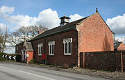
There were three churches or chapels in the 19th century, Congregational (1809), Wesleyan Methodist (1832) and Church of England (1847); the Wesleyan Methodist Chapel at Bradfield Green has closed. In 1840, a school was built at Bradfield Green; it had over a hundred pupils in 1900, but has since closed. The parish suffered bombing during the Second World War
, with two fatalities.
and Woolstanwood
. Of 22 parish councillors, seven represent Minshull Vernon, eleven represent Leighton (eight from Leighton Urban and three from Leighton Rural) and four represent Woolstanwood. Current Parish Councillors (as of August 2010) are: Mr A Forrest (Leighton Rural), Mrs L Horne (Leighton Rural), Mr J Parker (Leighton Rural), Mr K Halford (Minshull Vernon) (Vice Chair), Mr R Hollinshead (Minshull Vernon), Mr L Horne (Minshull Vernon), Mr M McGlone (Minshull Vernon), Mr B Palin (Minshull Vernon), Mr J Whittingham (Minshull Vernon), Mr D Preece (Leighton Urban), Mr B Barnes (Leighton Urban), Mr T Beard (Leighton Urban), Mr D Bebbington (Leighton Urban), Mr D Forrest (Leighton Urban) (Chair), Mr J Winstanley (Leighton Urban), Mrs P Butterill (Woolstandwood) and Mr M Wilson (Woolstanwood).
There are currently five seats vacant on the Parish Council; two representing Woolstanwood, one representing Minshull Vernon and two representing Leighton Urban.
From 1974 the civil parish was served by Crewe and Nantwich
Borough Council, which was succeeded on 1 April 2009 by the new unitary authority
of Cheshire East
.
Minshull Vernon falls in the parliamentary constituency of Eddisbury
, and has been represented by Stephen O'Brien since 1999.
 The civil parish has a total area of 2736 acres (1,107.2 ha). The area is relatively flat, with an average elevation of around 50 metres. The civil parish is largely rural, with the major land use being agricultural, predominantly pasture
. A short stretch of the River Weaver
forms part of the northern boundary of the parish and Hoggins Brook runs along its eastern boundary; several unnamed brooks also run through the parish, and numerous small meres and ponds are scattered across the area. The parish contains several areas of woodland, including Burnt Covert, Larch Wood, Spring Plantation, Worsley Covert and parts of Polestead Wood and Weaver Bank Wood. Two small areas in the north west and south west of the parish, together with the western parish boundary, fall within the Weaver Valley Area of Special County Value. An underground gas storage plant is located south of Hole House at .
The A530
(Middlewich Road) runs north–south through the parish; Brookhouse Lane/Eardswick Lane loops round from the A530 near Walley's Green to rejoin it near Bradfield Green. Moss Lane and the B5076 (Flowers Lane) run east and southeast, respectively, from the A530 at Bradfield Green towards Barrows Green
. Cross Lane runs west from Brookhouse Lane/Eardswick Lane to Church Minshull
.
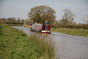 The Middlewich branch
of the Shropshire Union Canal
runs through the north-west of the parish, and forms the majority of the western boundary. Cross Lane crosses the canal via Minshullhill Bridge. The Crewe–Winsford
railway line runs north–south through the parish to the east of the A530. The Weaver Way follows the Shropshire Union towpath, and the Crewe and Nantwich Circular Walk
loops through the parish, in part also following the towpath.
 Minshull United Reformed Church is located at the junction of Cross Lane, Brookhouse Lane and Eardswick Lane. Originally a Congregational Chapel, the grade-II-listed church dates from 1809–10 and was substantially altered in around 1880. It is in brown brick with Victorian stained-glass windows featuring ogee
tracery
; a single original arched window with "Y" tracery survives in the north gable.
The Church of England parish church of St Peter's, Leighton
-cum-Minshull Vernon, on Middlewich Road north of Bradfield Green was founded in 1840. The present rock-faced building by John Matthews dates from 1847–9 and has a bell-cote and lancet window
s; it is listed at grade II.
s, which are believed to have come from Adderley Hall near Market Drayton
in Shropshire
. A small red-brick summerhouse
in the grounds, thought to have originally been a privy
, has a slate roof topped with a ball finial
. It dates from the same period as the hall, and is also listed at grade II.
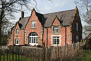
 Hoolgrave Manor on Eardswick Lane is a grade-II-listed hall, now a farmhouse, in brown brick on a U-shaped plan. Dating from the late 17th century, it features brick pilaster
s at the corners and a central slightly projecting bay with an oriel window
and topped with a pediment
. Eardswick Hall on Eardswick Lane is a grade-II-listed farmhouse which dates from 1849; the farmhouse and associated farm buildings enclose a courtyard. The farmhouse, in Jacobean
style, is in red brick with blue-brick diapering
and features cast-iron lozenge windows and decorative roof tiles. The farm buildings also have lozenge windows, as well as elaborately patterned ventilation holes. The existing farmhouse was built on the site of a 16th-century moated hall, demolished in 1849, which was partly in stone and partly timber framed
; the west, north and south arms of the moat survive. Several other farmhouses within the parish are also listed at grade II: the Dairy Farm House, Park House at Walley's Green and The Pines at Bradfield Green are all on Middlewich Road, and Woodhouse Farm House is on Brookhouse Lane. All are in red brick and date from the early or mid 19th century, although The Pines also has a rear wing which dates from the early 17th century.
 The Wharf on Cross Lane, adjacent to the Shropshire Union Canal
, is a grade-II-listed former canal warehouse and cottage which dates from around 1830 and is attributed to Thomas Telford
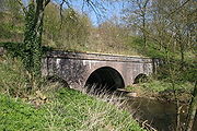
. In red brick, it is in late 17th century style and has three shaped gables to the main face, single shaped gables to the two ends, and a carriageway arch. Two aqueduct
s carrying the canal over the River Weaver
are listed at grade II. Five canal bridges are also grade II listed: Eardswick Bridge, Eardswick Hall Bridge, Hollingshead Bridge, Minshullhill Bridge and bridge number 18. The aqueducts and bridges all date from 1827–33; all are in brick with stone bands and copings, and all except Minshullhill Bridge are from designs by Telford.
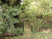
A double moat
ed site with an associated fishpond is located at ; the site dates from the medieval period and is a scheduled ancient monument. A war memorial in Bradfield Green (at ) commemorates those who died in the First World War
from Minshull Vernon and the adjacent parish of Leighton
. A stone cross erected in 1897 to mark Queen Victoria
's Diamond Jubilee stands at the junction of Middlewich Road and Brookhouse Lane in Walley's Green. The Coach and Horses public house is on Middlewich Road at Bradfield Green.
, while the southern half mainly falls within the catchment area of Warmingham Church of England Primary School in Warmingham
, there are two primary schools in a small area in the south-east corner in Mablins Lane Community Primary School and Leighton Primary School both in Leighton
. For secondary education, the northern half of the parish falls within the catchment area of Middlewich High School
in Middlewich
, and the southern half within that of Sir William Stanier Community School
in Crewe
.
Cheshire East
Cheshire East is a unitary authority area with borough status in the ceremonial county of Cheshire, England.The borough was established in April 2009 as part of the 2009 structural changes to local government in England, by virtue of an order under the Local Government and Public Involvement in...
and the ceremonial county of Cheshire
Cheshire
Cheshire is a ceremonial county in North West England. Cheshire's county town is the city of Chester, although its largest town is Warrington. Other major towns include Widnes, Congleton, Crewe, Ellesmere Port, Runcorn, Macclesfield, Winsford, Northwich, and Wilmslow...
, England. The hamlet lies 3 miles (5 km) to the north west of Crewe
Crewe
Crewe is a railway town within the unitary authority area of Cheshire East and the ceremonial county of Cheshire, England. According to the 2001 census the urban area had a population of 67,683...
, south east of Winsford
Winsford
Winsford is a town and civil parish within the unitary authority of Cheshire West and Chester and the ceremonial county of Cheshire, England. It lies on the River Weaver south of Northwich and west of Middlewich, and grew around the salt mining industry after the river was canalised in the...
and south west of Middlewich
Middlewich
Middlewich is a market town in the unitary authority of Cheshire East and the ceremonial county of Cheshire, England. It is east of the city of Chester, east of Winsford, southeast of Northwich and northwest of Sandbach....
. The parish also includes the small settlements of Bradfield Green, Eardswick, Hoolgrave, Minshull Hill, Walley's Green and Weaver Bank. The total population of the civil parish is somewhat over 200. Nearby villages include Church Minshull
Church Minshull
Church Minshull is a village and civil parish in the unitary authority of Cheshire East and the ceremonial county of Cheshire, England. The village is located approximately north west of Crewe and to the west of the River Weaver and the Shropshire Union Canal...
, Warmingham
Warmingham
Warmingham is a village and civil parish in the unitary authority of Cheshire East and the ceremonial county of Cheshire, England. The village lies 3¼ miles to the north of Crewe and 3¼ miles to the west of Sandbach. The parish also includes the settlement of Lane Ends. Nearby villages include...
and Wimboldsley
Wimboldsley
right|thumb|200px|Map of civil parish of Wimboldsley within the former borough of Vale RoyalWimboldsley is a village and civil parish in the unitary authority of Cheshire West and Chester and the ceremonial county of Cheshire, in the north west of England, approximately 2 miles south of...
.
The River Weaver
River Weaver
The River Weaver is a river, navigable in its lower reaches, running in a curving route anti-clockwise across west Cheshire, northern England. Improvements to the river to make it navigable were authorised in 1720 and the work, which included eleven locks, was completed in 1732...
and the Middlewich branch
Middlewich Branch
The Middlewich Branch of the Shropshire Union Canal is located in Cheshire, in the north west of England, and runs between Middlewich, where it joins the Trent and Mersey Canal, and Barbridge Junction, where it joins the main line of the Shropshire Union Canal...
of the Shropshire Union Canal
Shropshire Union Canal
The Shropshire Union Canal is a navigable canal in England; the Llangollen and Montgomery canals are the modern names of branches of the Shropshire Union system and lie partially in Wales....
run through the area.
History
A Roman roadRoman roads in Britain
Roman roads, together with Roman aqueducts and the vast standing Roman army , constituted the three most impressive features of the Roman Empire. In Britain, as in other provinces, the Romans constructed a comprehensive network of paved trunk roads Roman roads, together with Roman aqueducts and the...
between Nantwich
Nantwich
Nantwich is a market town and civil parish in the Borough of Cheshire East and the ceremonial county of Cheshire, England. The town gives its name to the parliamentary constituency of Crewe and Nantwich...
and Middlewich
Middlewich
Middlewich is a market town in the unitary authority of Cheshire East and the ceremonial county of Cheshire, England. It is east of the city of Chester, east of Winsford, southeast of Northwich and northwest of Sandbach....
ran northwards through the civil parish; several stretches of the road, as well as a Roman bridge, have been uncovered in excavations. Minshull Vernon and the adjacent parish of Church Minshull
Church Minshull
Church Minshull is a village and civil parish in the unitary authority of Cheshire East and the ceremonial county of Cheshire, England. The village is located approximately north west of Crewe and to the west of the River Weaver and the Shropshire Union Canal...
appear in the Domesday survey
Domesday Book
Domesday Book , now held at The National Archives, Kew, Richmond upon Thames in South West London, is the record of the great survey of much of England and parts of Wales completed in 1086...
as Maneshale, which formed part of the extensive lands of William Malbank (also William Malbedeng) and had a hawk's eyrie and four deer enclosures. The remains of two medieval moat
Moat
A moat is a deep, broad ditch, either dry or filled with water, that surrounds a castle, other building or town, historically to provide it with a preliminary line of defence. In some places moats evolved into more extensive water defences, including natural or artificial lakes, dams and sluices...
ed sites provide evidence for settlement during that period. In the Tudor period, Minshull Vernon formed part of the lands of the Venable family, lords of Middlewich. A description of the parish from the early 17th century records its great and spacious farms.
There were three churches or chapels in the 19th century, Congregational (1809), Wesleyan Methodist (1832) and Church of England (1847); the Wesleyan Methodist Chapel at Bradfield Green has closed. In 1840, a school was built at Bradfield Green; it had over a hundred pupils in 1900, but has since closed. The parish suffered bombing during the Second World War
World War II
World War II, or the Second World War , was a global conflict lasting from 1939 to 1945, involving most of the world's nations—including all of the great powers—eventually forming two opposing military alliances: the Allies and the Axis...
, with two fatalities.
Governance
Minshull Vernon is administered by Minshull Vernon and District Parish Council, jointly with LeightonLeighton, Cheshire
Leighton is a scattered settlement and civil parish in the unitary authority of Cheshire East and the ceremonial county of Cheshire, England, which lies immediately north west of Crewe. The parish also includes the village of Barrows Green , which lies on the northern outskirts of Crewe, 1½ miles...
and Woolstanwood
Woolstanwood
Woolstanwood is a village and civil parish in the unitary authority of Cheshire East and the ceremonial county of...
. Of 22 parish councillors, seven represent Minshull Vernon, eleven represent Leighton (eight from Leighton Urban and three from Leighton Rural) and four represent Woolstanwood. Current Parish Councillors (as of August 2010) are: Mr A Forrest (Leighton Rural), Mrs L Horne (Leighton Rural), Mr J Parker (Leighton Rural), Mr K Halford (Minshull Vernon) (Vice Chair), Mr R Hollinshead (Minshull Vernon), Mr L Horne (Minshull Vernon), Mr M McGlone (Minshull Vernon), Mr B Palin (Minshull Vernon), Mr J Whittingham (Minshull Vernon), Mr D Preece (Leighton Urban), Mr B Barnes (Leighton Urban), Mr T Beard (Leighton Urban), Mr D Bebbington (Leighton Urban), Mr D Forrest (Leighton Urban) (Chair), Mr J Winstanley (Leighton Urban), Mrs P Butterill (Woolstandwood) and Mr M Wilson (Woolstanwood).
There are currently five seats vacant on the Parish Council; two representing Woolstanwood, one representing Minshull Vernon and two representing Leighton Urban.
From 1974 the civil parish was served by Crewe and Nantwich
Crewe and Nantwich
Crewe and Nantwich was, from 1974 to 2009, a local government district with borough status in Cheshire, England. It had a population of 111,007...
Borough Council, which was succeeded on 1 April 2009 by the new unitary authority
Unitary authority
A unitary authority is a type of local authority that has a single tier and is responsible for all local government functions within its area or performs additional functions which elsewhere in the relevant country are usually performed by national government or a higher level of sub-national...
of Cheshire East
Cheshire East
Cheshire East is a unitary authority area with borough status in the ceremonial county of Cheshire, England.The borough was established in April 2009 as part of the 2009 structural changes to local government in England, by virtue of an order under the Local Government and Public Involvement in...
.
Minshull Vernon falls in the parliamentary constituency of Eddisbury
Eddisbury (UK Parliament constituency)
Eddisbury is a county constituency represented in the House of Commons of the Parliament of the United Kingdom. It elects one Member of Parliament by the first-past-the-post system of election.- Boundaries :...
, and has been represented by Stephen O'Brien since 1999.
Geography, transport and economy
Pasture
Pasture is land used for grazing. Pasture lands in the narrow sense are enclosed tracts of farmland, grazed by domesticated livestock, such as horses, cattle, sheep or swine. The vegetation of tended pasture, forage, consists mainly of grasses, with an interspersion of legumes and other forbs...
. A short stretch of the River Weaver
River Weaver
The River Weaver is a river, navigable in its lower reaches, running in a curving route anti-clockwise across west Cheshire, northern England. Improvements to the river to make it navigable were authorised in 1720 and the work, which included eleven locks, was completed in 1732...
forms part of the northern boundary of the parish and Hoggins Brook runs along its eastern boundary; several unnamed brooks also run through the parish, and numerous small meres and ponds are scattered across the area. The parish contains several areas of woodland, including Burnt Covert, Larch Wood, Spring Plantation, Worsley Covert and parts of Polestead Wood and Weaver Bank Wood. Two small areas in the north west and south west of the parish, together with the western parish boundary, fall within the Weaver Valley Area of Special County Value. An underground gas storage plant is located south of Hole House at .
The A530
A530 road
The A530 road is a road linking the A525 east of Whitchurch, Shropshire, England with the A559 east of Northwich, in Cheshire. The road follows the route:*A525*Nantwich*Crewe*Middlewich*A559...
(Middlewich Road) runs north–south through the parish; Brookhouse Lane/Eardswick Lane loops round from the A530 near Walley's Green to rejoin it near Bradfield Green. Moss Lane and the B5076 (Flowers Lane) run east and southeast, respectively, from the A530 at Bradfield Green towards Barrows Green
Leighton, Cheshire
Leighton is a scattered settlement and civil parish in the unitary authority of Cheshire East and the ceremonial county of Cheshire, England, which lies immediately north west of Crewe. The parish also includes the village of Barrows Green , which lies on the northern outskirts of Crewe, 1½ miles...
. Cross Lane runs west from Brookhouse Lane/Eardswick Lane to Church Minshull
Church Minshull
Church Minshull is a village and civil parish in the unitary authority of Cheshire East and the ceremonial county of Cheshire, England. The village is located approximately north west of Crewe and to the west of the River Weaver and the Shropshire Union Canal...
.
Middlewich Branch
The Middlewich Branch of the Shropshire Union Canal is located in Cheshire, in the north west of England, and runs between Middlewich, where it joins the Trent and Mersey Canal, and Barbridge Junction, where it joins the main line of the Shropshire Union Canal...
of the Shropshire Union Canal
Shropshire Union Canal
The Shropshire Union Canal is a navigable canal in England; the Llangollen and Montgomery canals are the modern names of branches of the Shropshire Union system and lie partially in Wales....
runs through the north-west of the parish, and forms the majority of the western boundary. Cross Lane crosses the canal via Minshullhill Bridge. The Crewe–Winsford
Winsford
Winsford is a town and civil parish within the unitary authority of Cheshire West and Chester and the ceremonial county of Cheshire, England. It lies on the River Weaver south of Northwich and west of Middlewich, and grew around the salt mining industry after the river was canalised in the...
railway line runs north–south through the parish to the east of the A530. The Weaver Way follows the Shropshire Union towpath, and the Crewe and Nantwich Circular Walk
Crewe and Nantwich Circular Walk
The Crewe and Nantwich Circular Walk is a long-distance walkers' path in the Cheshire East area of Cheshire, England. As the name suggests, the walk forms a circuit around the towns of Crewe and Nantwich...
loops through the parish, in part also following the towpath.
Demography
In 2006, the total population of the civil parish was estimated as 240. The 2001 census recorded a population of 224, in 94 households. This is around 60% of the population of 1851; the historical population figures were 357 (1801), 375 (1851), 302 (1901) and 267 (1951).Places of worship
Ogee
An ogee is a curve , shaped somewhat like an S, consisting of two arcs that curve in opposite senses, so that the ends are parallel....
tracery
Tracery
In architecture, Tracery is the stonework elements that support the glass in a Gothic window. The term probably derives from the 'tracing floors' on which the complex patterns of late Gothic windows were laid out.-Plate tracery:...
; a single original arched window with "Y" tracery survives in the north gable.
The Church of England parish church of St Peter's, Leighton
Leighton, Cheshire
Leighton is a scattered settlement and civil parish in the unitary authority of Cheshire East and the ceremonial county of Cheshire, England, which lies immediately north west of Crewe. The parish also includes the village of Barrows Green , which lies on the northern outskirts of Crewe, 1½ miles...
-cum-Minshull Vernon, on Middlewich Road north of Bradfield Green was founded in 1840. The present rock-faced building by John Matthews dates from 1847–9 and has a bell-cote and lancet window
Lancet window
A lancet window is a tall narrow window with a pointed arch at its top. It acquired the "lancet" name from its resemblance to a lance. Instances of this architectural motif are most often found in Gothic and ecclesiastical structures, where they are often placed singly or in pairs.The motif first...
s; it is listed at grade II.
Other landmarks
Newfield Hall on Middlewich Road in Walley's Green is a red-brick mansion on a double pile plan which dates from the early 19th century; it is listed at grade II. The west front is flanked by stone elephants bearing howdahHowdah
A howdah, or houdah, also known as hathi howdah, is a carriage which is positioned on the back of an elephant, or occasionally some other animal, used most often in the past to carry wealthy people or for use in hunting or warfare...
s, which are believed to have come from Adderley Hall near Market Drayton
Market Drayton
Market Drayton is a small market town in north Shropshire, England. It is on the River Tern, between Shrewsbury and Stoke-on-Trent, and was formerly known as "Drayton in Hales" and earlier simply as "Drayton" ....
in Shropshire
Shropshire
Shropshire is a county in the West Midlands region of England. For Eurostat purposes, the county is a NUTS 3 region and is one of four counties or unitary districts that comprise the "Shropshire and Staffordshire" NUTS 2 region. It borders Wales to the west...
. A small red-brick summerhouse
Summerhouse
Summerhouse can refer to:*Summer house*Summerhouse, County Durham*"The Summerhouse", a song by The Divine Comedy...
in the grounds, thought to have originally been a privy
Outhouse
An outhouse is a small structure separate from a main building which often contained a simple toilet and may possibly also be used for housing animals and storage.- Terminology :...
, has a slate roof topped with a ball finial
Finial
The finial is an architectural device, typically carved in stone and employed decoratively to emphasize the apex of a gable or any of various distinctive ornaments at the top, end, or corner of a building or structure. Smaller finials can be used as a decorative ornament on the ends of curtain rods...
. It dates from the same period as the hall, and is also listed at grade II.
Pilaster
A pilaster is a slightly-projecting column built into or applied to the face of a wall. Most commonly flattened or rectangular in form, pilasters can also take a half-round form or the shape of any type of column, including tortile....
s at the corners and a central slightly projecting bay with an oriel window
Oriel window
Oriel windows are a form of bay window commonly found in Gothic architecture, which project from the main wall of the building but do not reach to the ground. Corbels or brackets are often used to support this kind of window. They are seen in combination with the Tudor arch. This type of window was...
and topped with a pediment
Pediment
A pediment is a classical architectural element consisting of the triangular section found above the horizontal structure , typically supported by columns. The gable end of the pediment is surrounded by the cornice moulding...
. Eardswick Hall on Eardswick Lane is a grade-II-listed farmhouse which dates from 1849; the farmhouse and associated farm buildings enclose a courtyard. The farmhouse, in Jacobean
Jacobethan
Jacobethan is the style designation coined in 1933 by John Betjeman to describe the mixed national Renaissance revival style that was made popular in England from the late 1820s, which derived most of its inspiration and its repertory from the English Renaissance , with elements of Elizabethan and...
style, is in red brick with blue-brick diapering
Diapering
Diaper is any of a wide range of decorative patterns used in a variety of works of art, such as stained glass, heraldic shields, architecture, silverwork etc. Its chief use is in the enlivening of plain surfaces.-Etymology:...
and features cast-iron lozenge windows and decorative roof tiles. The farm buildings also have lozenge windows, as well as elaborately patterned ventilation holes. The existing farmhouse was built on the site of a 16th-century moated hall, demolished in 1849, which was partly in stone and partly timber framed
Timber framing
Timber framing , or half-timbering, also called in North America "post-and-beam" construction, is the method of creating structures using heavy squared off and carefully fitted and joined timbers with joints secured by large wooden pegs . It is commonplace in large barns...
; the west, north and south arms of the moat survive. Several other farmhouses within the parish are also listed at grade II: the Dairy Farm House, Park House at Walley's Green and The Pines at Bradfield Green are all on Middlewich Road, and Woodhouse Farm House is on Brookhouse Lane. All are in red brick and date from the early or mid 19th century, although The Pines also has a rear wing which dates from the early 17th century.
Shropshire Union Canal
The Shropshire Union Canal is a navigable canal in England; the Llangollen and Montgomery canals are the modern names of branches of the Shropshire Union system and lie partially in Wales....
, is a grade-II-listed former canal warehouse and cottage which dates from around 1830 and is attributed to Thomas Telford
Thomas Telford
Thomas Telford FRS, FRSE was a Scottish civil engineer, architect and stonemason, and a noted road, bridge and canal builder.-Early career:...
. In red brick, it is in late 17th century style and has three shaped gables to the main face, single shaped gables to the two ends, and a carriageway arch. Two aqueduct
Aqueduct
An aqueduct is a water supply or navigable channel constructed to convey water. In modern engineering, the term is used for any system of pipes, ditches, canals, tunnels, and other structures used for this purpose....
s carrying the canal over the River Weaver
River Weaver
The River Weaver is a river, navigable in its lower reaches, running in a curving route anti-clockwise across west Cheshire, northern England. Improvements to the river to make it navigable were authorised in 1720 and the work, which included eleven locks, was completed in 1732...
are listed at grade II. Five canal bridges are also grade II listed: Eardswick Bridge, Eardswick Hall Bridge, Hollingshead Bridge, Minshullhill Bridge and bridge number 18. The aqueducts and bridges all date from 1827–33; all are in brick with stone bands and copings, and all except Minshullhill Bridge are from designs by Telford.
A double moat
Moat
A moat is a deep, broad ditch, either dry or filled with water, that surrounds a castle, other building or town, historically to provide it with a preliminary line of defence. In some places moats evolved into more extensive water defences, including natural or artificial lakes, dams and sluices...
ed site with an associated fishpond is located at ; the site dates from the medieval period and is a scheduled ancient monument. A war memorial in Bradfield Green (at ) commemorates those who died in the First World War
World War I
World War I , which was predominantly called the World War or the Great War from its occurrence until 1939, and the First World War or World War I thereafter, was a major war centred in Europe that began on 28 July 1914 and lasted until 11 November 1918...
from Minshull Vernon and the adjacent parish of Leighton
Leighton, Cheshire
Leighton is a scattered settlement and civil parish in the unitary authority of Cheshire East and the ceremonial county of Cheshire, England, which lies immediately north west of Crewe. The parish also includes the village of Barrows Green , which lies on the northern outskirts of Crewe, 1½ miles...
. A stone cross erected in 1897 to mark Queen Victoria
Victoria of the United Kingdom
Victoria was the monarch of the United Kingdom of Great Britain and Ireland from 20 June 1837 until her death. From 1 May 1876, she used the additional title of Empress of India....
's Diamond Jubilee stands at the junction of Middlewich Road and Brookhouse Lane in Walley's Green. The Coach and Horses public house is on Middlewich Road at Bradfield Green.
Education
There are no educational facilities in Minshull Vernon. For primary education, the northern half of the civil parish falls within the catchment area of Wimboldsley Community Primary School in WimboldsleyWimboldsley
right|thumb|200px|Map of civil parish of Wimboldsley within the former borough of Vale RoyalWimboldsley is a village and civil parish in the unitary authority of Cheshire West and Chester and the ceremonial county of Cheshire, in the north west of England, approximately 2 miles south of...
, while the southern half mainly falls within the catchment area of Warmingham Church of England Primary School in Warmingham
Warmingham
Warmingham is a village and civil parish in the unitary authority of Cheshire East and the ceremonial county of Cheshire, England. The village lies 3¼ miles to the north of Crewe and 3¼ miles to the west of Sandbach. The parish also includes the settlement of Lane Ends. Nearby villages include...
, there are two primary schools in a small area in the south-east corner in Mablins Lane Community Primary School and Leighton Primary School both in Leighton
Leighton, Cheshire
Leighton is a scattered settlement and civil parish in the unitary authority of Cheshire East and the ceremonial county of Cheshire, England, which lies immediately north west of Crewe. The parish also includes the village of Barrows Green , which lies on the northern outskirts of Crewe, 1½ miles...
. For secondary education, the northern half of the parish falls within the catchment area of Middlewich High School
Middlewich High School
Middlewich High School is a small specialist Science, Mathematics & Computing secondary school in Middlewich, Cheshire. It is a mixed-sex school containing 11–16 year olds and has 700 pupils on roll as of the last OFSTED report: less than the average comprehensive. In its last OFSTED report,...
in Middlewich
Middlewich
Middlewich is a market town in the unitary authority of Cheshire East and the ceremonial county of Cheshire, England. It is east of the city of Chester, east of Winsford, southeast of Northwich and northwest of Sandbach....
, and the southern half within that of Sir William Stanier Community School
Sir William Stanier Community School
Sir William Stanier Community School is a secondary school located in Crewe, Cheshire.- Establishment :Sir William Stanier Community School was officially established when Coppenhall High School & Victoria Community Technology School merged together in 2008...
in Crewe
Crewe
Crewe is a railway town within the unitary authority area of Cheshire East and the ceremonial county of Cheshire, England. According to the 2001 census the urban area had a population of 67,683...
.